View
Add
Copy
Edit
Delete
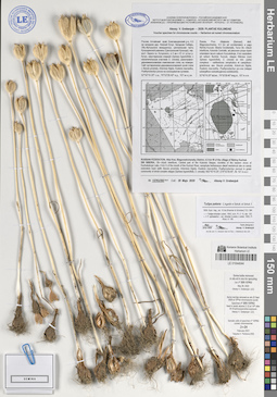
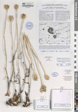
LE 01044044
Tulipa patens C. Agardh ex Schult. & Schult. f. det. Grebenjuk, Аlexey Viktorovich at 05.2020
Collectors: Grebenjuk, Аlexey Viktorovich Field collecting number: 137KU393. Collection date: 28.05.2020. Administrative regions: RU - Russian Federation; RU - Altayskiy Kray; RU - Altayskiy Kray - Blagoveshchenskiy Rayon. Топоним: озеро Кучукское. Place of collection: 4.5 км западнее дер. Нижний Кучук, в 4 км к Ю от устья р. Кучук.Expedition: Alexey V. Grebenjuk. Plantae Kulundae ()Groups of specimens: Образцы сектора Сибири и Дальнего Востока России; Соглашение Минобрнауки №075-15-2021-1056; Alexey V. Grebenjuk. Voucher specimens for chromosome countsOriginal label text:Alexey V. Grebenjuk — 2020: PLANTAE KULUNDAE
Voucher specimen for chromosome counts — Herbarium ad numeri chromosomatum
Россия, Алтайский край, Благовещенский р-н, 4.5 км западнее дер. Нижний Кучук.
Западная Сибирь, Обь-Иртышское междуречье, центральная часть Кулундинской равнины (Центральная Кулунда), окр. вост. берега оз. Кучукского, в 4 км к Ю от устья р. Кучук, закустаренная спиреей (Spiraea hypericifolia, с незначительным участием S. crenata), разнотравно-дерновиннозлаковая комплексная степь на плакоре. Сайт кустарничково-дерновиннозлаковой сухой степи с Bassia prostrata, Artemisia frigida, Koeleria macrantha, Psathyrostachys juncea на солонцеватом суглинке.
52°42'10.20" с.ш., 79°52'28.40" в.д., 107 м н.у.м.
RUSSIAN FEDERATION, Altai Krai, Blagoveshchensky District, 4.5 km W of the village of Nizhny Kuchuk.
SW SIBERIA, Ob—Irtysh interfluve, Central part of the Kulunda Steppe, vicinities of the eastern shore of Kuchukskoye Lake, 4 km S of the mouth of the Kuchuk River, xerophyte herbaceous–dwarf semishrub site on sandy solonetzic loam (with Bassia prostrata, Artemisia frigida, Koeleria macrantha, Psathyrostachys juncea) in grass community of shrub complex steppe (Spiraea hypericifolia, S. crenata).
N52°42'10.20", E79°52'28.40", Alt. 107 m a.s.l.
№ 137KU393 Coll.: 28 Majo 2020 Alexey V. Grebenjuk
Rossia, Prov. Altajensis (Barnaul), distr. Blagovesczhenka, 4.5 km ad occidentalem a pagо Nizhnij Kuczuk;
Siberia Occidentalis, Terra Ob—Irtisch interfluvia, Kulunda Centralis, ad placorem prope ripam orientalem lacum salsum Kuczukskoje, 4 km australem ad ostium fluminis Kuczuk, steppa fruticosa (cum Spiraea hypericifolia, S. crenata ex min. parte) complexa – variiherbosa xerophytica et caespitoso-graminosa; ass. Bassia prostrata, Artemisia frigida, Koeleria macrantha, Psathyrostachys juncea (steppa subargilloso-subsalsuginosa subdeserta). 52°42'10.20" lat.bor., 79°52'28.40" long.or., 107 m s.m.
Some bulbs removed in situ et in vivo for sprouting
Coll. nº 20X-137KU
May 28, 2020
Alexey V. Grebenjuk (LE)
Some root-tips removed ex situ 22 Sept. 2020 at 10:30 for chromosome counts
Specimen nº 20X-137KU
fixed in acetic alcohol (1:3) at 14:30 after 4h 8-hydroxyquinoline exposure
Alexey V. Grebenjuk (LE)
Somatic cells of specimen nº 20X-137KU contain 2n=24 chromosomes
February 2021
Tatyana V. Pankova (NS)
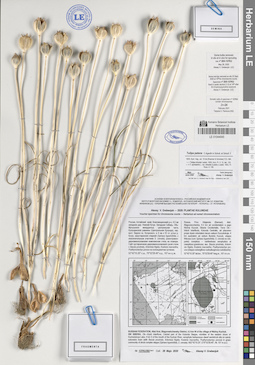
LE 01044045
Tulipa patens C. Agardh ex Schult. & Schult. f. det. Grebenjuk, Аlexey Viktorovich at 05.2020
Collectors: Grebenjuk, Аlexey Viktorovich Field collecting number: 137KU392. Collection date: 28.05.2020. Administrative regions: RU - Russian Federation; RU - Altayskiy Kray; RU - Altayskiy Kray - Blagoveshchenskiy Rayon. Топоним: озеро Кучукское. Place of collection: 4.5 км западнее дер. Нижний Кучук, в 4 км к Ю от устья р. Кучук.Expedition: Alexey V. Grebenjuk. Plantae Kulundae ()Groups of specimens: Образцы сектора Сибири и Дальнего Востока России; Соглашение Минобрнауки №075-15-2021-1056; Alexey V. Grebenjuk. Voucher specimens for chromosome countsOriginal label text:Alexey V. Grebenjuk — 2020: PLANTAE KULUNDAE
Voucher specimen for chromosome counts — Herbarium ad numeri chromosomatum
Россия, Алтайский край, Благовещенский р-н, 4.5 км западнее дер. Нижний Кучук.
Западная Сибирь, Обь-Иртышское междуречье, центральная часть Кулундинской равнины (Центральная Кулунда), окр. вост. берега оз. Кучукского, в 4 км к Ю от устья р. Кучук, закустаренная спиреей (Spiraea hypericifolia, с незначительным участием S. crenata), разнотравно-дерновиннозлаковая комплексная степь на плакоре. Сайт кустарничково-дерновиннозлаковой сухой степи с Bassia prostrata, Artemisia frigida, Koeleria macrantha, Psathyrostachys juncea на солонцеватом суглинке.
52°42'10.20" с.ш., 79°52'28.40" в.д., 107 м н.у.м.
RUSSIAN FEDERATION, Altai Krai, Blagoveshchensky District, 4.5 km W of the village of Nizhny Kuchuk.
SW SIBERIA, Ob—Irtysh interfluve, Central part of the Kulunda Steppe, vicinities of the eastern shore of Kuchukskoye Lake, 4 km S of the mouth of the Kuchuk River, xerophyte herbaceous–dwarf semishrub site on sandy solonetzic loam (with Bassia prostrata, Artemisia frigida, Koeleria macrantha, Psathyrostachys juncea) in grass community of shrub complex steppe (Spiraea hypericifolia, S. crenata).
N52°42'10.20", E79°52'28.40", Alt. 107 m a.s.l.
№ 137KU392 Coll.: 28 Majo 2020 Alexey V. Grebenjuk
Rossia, Prov. Altajensis (Barnaul), distr. Blagovesczhenka, 4.5 km ad occidentalem a pagо Nizhnij Kuczuk;
Siberia Occidentalis, Terra Ob—Irtisch interfluvia, Kulunda Centralis, ad placorem prope ripam orientalem lacum salsum Kuczukskoje, 4 km australem ad ostium fluminis Kuczuk, steppa fruticosa (cum Spiraea hypericifolia, S. crenata ex min. parte) complexa – variiherbosa xerophytica et caespitoso-graminosa; ass. Bassia prostrata, Artemisia frigida, Koeleria macrantha, Psathyrostachys juncea (steppa subargilloso-subsalsuginosa subdeserta). 52°42'10.20" lat.bor., 79°52'28.40" long.or., 107 m s.m.
Some bulbs removed in situ et in vivo for sprouting
Coll. nº 20X-137KU
May 28, 2020
Alexey V. Grebenjuk (LE)
Some root-tips removed ex situ 22 Sept. 2020 at 10:30 for chromosome counts
Specimen nº 20X-137KU
fixed in acetic alcohol (1:3) at 14:30 after 4h 8-hydroxyquinoline exposure
Alexey V. Grebenjuk (LE)
Somatic cells of specimen nº 20X-137KU contain 2n=24 chromosomes
February 2021
Tatyana V. Pankova (NS)
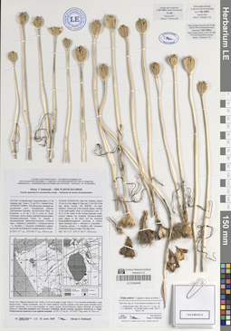
LE 01044046
Tulipa patens C. Agardh ex Schult. & Schult. f. det. Grebenjuk, Аlexey Viktorovich at 06.2020
Collectors: Grebenjuk, Аlexey Viktorovich Field collecting number: 188KU709. Collection date: 25.06.2020. Administrative regions: RU - Russian Federation; RU - Altayskiy Kray; RU - Altayskiy Kray - Rodinskiy Rayon. Топоним: озеро Кучукское. Place of collection: 6.5 км севернее дер. Тизек и 7.5 км ЮЗ с. Нижний Кучук; юго-восточный берег оз. Кучукского, в 2.5 км к СВ от устья рч. Кучук-Солоновка.Expedition: Alexey V. Grebenjuk. Plantae Kulundae ()Groups of specimens: Образцы сектора Сибири и Дальнего Востока России; Соглашение Минобрнауки №075-15-2021-1056; Alexey V. Grebenjuk. Voucher specimens for chromosome countsOriginal label text:Alexey V. Grebenjuk — 2020: PLANTAE KULUNDAE
Voucher specimen for chromosome counts — Herbarium ad numeri chromosomatum
РОССИЯ, Алтайский край, Родинский район, 6.5 км севернее дер. Тизек и 7.5 км ЮЗ с. Нижний Кучук.
Западная Сибирь, Обь-Иртышское междуречье, центральная часть Кулундинской равнины (Центральная Кулунда), юго-восточный берег оз. Кучукского, в 2.5 км к СВ от устья рч. Кучук-Солоновка, экотон между ксерофитноразнотравно-типчаково-ковыльной степью на плакоре и экстразональной биюргуново-полынной (Anabasis salsa — Artemisia cf. schischkinii — Orostachys spinosa + O. thyrsiflora, c Tanacetum achilleifolium) северно-пустынной группировкой по кромке высокого берега.
52°39'11.27" с.ш., 79°51'49.77" в.д., 105 м н.у.м.
RUSSIAN FEDERATION, Altai Krai, Rodinsky District, 6.5 km N of the village of Tizek and 7.5 km SW of the selo Nizhny Kuchuk.
SW SIBERIA, Ob—Irtysh interfluve, Central part of the Kulunda Steppe, vicinities of the south-eastern shore of Kuchukskoye Lake, 2.5 km N of the mouth of the Kuchuk-Solonovka rivulet, ecotone between the xerophytic forb-fescue-feather grass steppe on the placor and the extrazonal biurgun[saltwort]-sagebrush community of northern desert (Anabasis salsa — Artemisia cf. schischkinii —Orostachys spinosa + O. thyrsiflora, with Tanacetum achilleifolium) along the edge of the high shore.
N52° 39' 11.27", E79° 51' 49.77", 105 m a.s.l.
[see also LATIN.]
№ 188KU709 1ex1 Coll.: 25 Junio 2020 Alexey V. Grebenjuk
Some bulbs removed in situ et in vivo for sprouting
Coll. nº 20X-188KU
June 25, 2020
Alexey V. Grebenjuk (LE)
Some root-tips removed ex situ 22 Sept. 2020 at 10:30 for chromosome counts
Specimen nº 20X-188KU
fixed in acetic alcohol (1:3) at 14:30 after 4h 8-hydroxyquinoline exposure
Alexey V. Grebenjuk (LE)
Somatic cells of specimen nº 20X-188KU contain 2n=24 chromosomes
February 2021
Tatyana V. Pankova (NS)
Rossia, Prov. Altajensis (Barnaul), distr. Rodino, 6.5 km ad borealem a pago Tizek et 7.5 km ad austro-occidentalem a pagо Nizhnij Kuczuk. // Siberia Occidentalis, Terra Ob—Irtisch interfluvia, Kulunda Centralis, prope ripam austro-orientalem lacum salsum Kuczukskoje, 2.5 km boreo-orientalem ad ostium amniculi Kuczuk-Solonovka, steppa intermedia ad marginem desertorum. Associatio transitoria cum Tanacetum achilleifolia, Bassia prostrata, Agropyron desertorum, A. fragile, Psathyrostachys hyalantha in locis argilloso-subsalsis. 52°39'11.27" lat. bor., 79°51'49.77" long. orient. Alt. 105 m s.m.
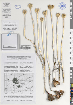
LE 01044047
Tulipa patens C. Agardh ex Schult. & Schult. f. det. Grebenjuk, Аlexey Viktorovich at 07.2020
Collectors: Grebenjuk, Аlexey Viktorovich Field collecting number: 247KU819. Collection date: 15.07.2020. Administrative regions: RU - Russian Federation; RU - Altayskiy Kray; RU - Altayskiy Kray - Blagoveshchenskiy Rayon. Топоним: оз. Кулундинское. Place of collection: 8 км севернее п.г.т. Благовещенка и в 14 км юго-западнее села Шимолино, между оз. Ягодное и Горчина, в 4 км южнее р. Солоновка (левый рукав дельты р. Кулунда).Expedition: Alexey V. Grebenjuk. Plantae Kulundae ()Groups of specimens: Образцы сектора Сибири и Дальнего Востока России; Соглашение Минобрнауки №075-15-2021-1056; Alexey V. Grebenjuk. Voucher specimens for chromosome countsOriginal label text:Alexey V. Grebenjuk — 2020: PLANTAE KULUNDAE
Voucher specimen for chromosome counts — Herbarium ad numeri chromosomatum
РОССИЯ, Алтайский край, Благовещенский район, в 8 км севернее п.г.т. Благовещенка и в 14 км юго-западнее села Шимолино.
Западная Сибирь, Обь-Иртышское междуречье, центральная часть Кулундинской равнины (Центральная Кулунда), левобережье р. Кулунда, близ ее устья (в 4 км к Ю от р. Солоновка – левого рукава дельты), окрестности ЮВ берега оз. Кулундинское, плакор между остаточными г.-сол. оз. Ягодное и Горчина. Ксерофитноразнотравно-типчаково-ковыльная степь с пятнами кустарников Spiraea hypericifolia.
52° 54' 54.74" с.ш., 79° 49' 33.53" в.д., 100 м н.у.м.
RUSSIAN FEDERATION, Altai Krai, Blagoveshchensky District, 8 km N of the urban-type settlement of Blagoveshchenka and 14 km SW of the selo Shimolino.
SW SIBERIA, Ob—Irtysh interfluve, Central part of the Kulunda Steppe, Left-bank of Kulunda River near its mouth (4 km S of Solonovka River – is a left distributaries of Kulunda River Delta), vicinities of the south-eastern shore of Kulundinskoye Lake, plakor between hypersaline lakes Yagodnoe and Gorchina. Xerophytic forb-fescue-feather grass steppe with sites of shrubs Spiraea hypericifolia.
N52° 54' 54.74", E79° 49' 33.53", 100 m a.s.l.
№ 247KU819 Coll.: 15 Julio 2020 Alexey V. et V. I. Grebenjuk
Some bulbs removed in situ et in vivo for sprouting
Coll. nº 20X-247KU
July 15, 2020
Alexey V. Grebenjuk (LE)
Some root-tips removed ex situ 22 Sept. 2020 at 10:30 for chromosome counts
Specimen nº 20X-247KU
fixed in acetic alcohol (1:3) at 14:30 after 4h 8-hydroxyquinoline exposure
Alexey V. Grebenjuk (LE)
Somatic cells of specimen nº 20X-247KU contain 2n=24 chromosomes
February 2021
Tatyana V. Pankova (NS)
Rossia, Prov. Altajensis (Barnaul), distr. Blagovesczhenka, 8 km ad borealem ab oppidul. Blagovesczhenka et 14 km ad austro-occidentalem a pagо Schimolino // Siberia Occidentalis, Terra Ob—Irtisch interfluvia, Kulunda Centralis, regio ripae sinistrae adjacens prope ostium fl. Kulunda et prope ripam austro-orientalem lacum salsum Kulundinskoje, 2.5 km ad australem fl. Solonovka (ramus sinistr. ex syst. deltae fl. Kulunda), placor inter lac. sals. Jagodnoje et Gortschina. Steppa variiherboso-xerophytica—caespitoso-graminosa et hic illic fruticosa (Spiraea hypericifolia). 52° 54' 54.74" lat. bor., 79° 49' 33.53" long. orient. Alt. 100 m s.m.
LE 01044048
Tulipa patens C. Agardh ex Schult. & Schult. f. det. Grebenjuk, Аlexey Viktorovich at 07.2020
Collectors: Grebenjuk, Аlexey Viktorovich Field collecting number: 247KU820. Collection date: 15.07.2020. Administrative regions: RU - Russian Federation; RU - Altayskiy Kray; RU - Altayskiy Kray - Blagoveshchenskiy Rayon. Топоним: оз. Кулундинское. Place of collection: 8 км севернее п.г.т. Благовещенка и в 14 км юго-западнее села Шимолино, между оз. Ягодное и Горчина, в 4 км южнее р. Солоновка (левый рукав дельты р. Кулунда).Expedition: Alexey V. Grebenjuk. Plantae Kulundae ()Groups of specimens: Образцы сектора Сибири и Дальнего Востока России; Соглашение Минобрнауки №075-15-2021-1056; Alexey V. Grebenjuk. Voucher specimens for chromosome countsOriginal label text:Alexey V. Grebenjuk — 2020: PLANTAE KULUNDAE
Voucher specimen for chromosome counts — Herbarium ad numeri chromosomatum
РОССИЯ, Алтайский край, Благовещенский район, в 8 км севернее п.г.т. Благовещенка и в 14 км юго-западнее села Шимолино.
Западная Сибирь, Обь-Иртышское междуречье, центральная часть Кулундинской равнины (Центральная Кулунда), левобережье р. Кулунда, близ ее устья (в 4 км к Ю от р. Солоновка – левого рукава дельты), окрестности ЮВ берега оз. Кулундинское, плакор между остаточными г.-сол. оз. Ягодное и Горчина. Ксерофитноразнотравно-типчаково-ковыльная степь с пятнами кустарников Spiraea hypericifolia.
52° 54' 54.74" с.ш., 79° 49' 33.53" в.д., 100 м н.у.м.
RUSSIAN FEDERATION, Altai Krai, Blagoveshchensky District, 8 km N of the urban-type settlement of Blagoveshchenka and 14 km SW of the selo Shimolino.
SW SIBERIA, Ob—Irtysh interfluve, Central part of the Kulunda Steppe, Left-bank of Kulunda River near its mouth (4 km S of Solonovka River – is a left distributaries of Kulunda River Delta), vicinities of the south-eastern shore of Kulundinskoye Lake, plakor between hypersaline lakes Yagodnoe and Gorchina. Xerophytic forb-fescue-feather grass steppe with sites of shrubs Spiraea hypericifolia.
N52° 54' 54.74", E79° 49' 33.53", 100 m a.s.l.
№ 247KU820 Coll.: 15 Julio 2020 Alexey V. et V. I. Grebenjuk
Some bulbs removed in situ et in vivo for sprouting
Coll. nº 20X-247KU
July 15, 2020
Alexey V. Grebenjuk (LE)
Some root-tips removed ex situ 22 Sept. 2020 at 10:30 for chromosome counts
Specimen nº 20X-247KU
fixed in acetic alcohol (1:3) at 14:30 after 4h 8-hydroxyquinoline exposure
Alexey V. Grebenjuk (LE)
Somatic cells of specimen nº 20X-247KU contain 2n=24 chromosomes
February 2021
Tatyana V. Pankova (NS)
Rossia, Prov. Altajensis (Barnaul), distr. Blagovesczhenka, 8 km ad borealem ab oppidul. Blagovesczhenka et 14 km ad austro-occidentalem a pagо Schimolino // Siberia Occidentalis, Terra Ob—Irtisch interfluvia, Kulunda Centralis, regio ripae sinistrae adjacens prope ostium fl. Kulunda et prope ripam austro-orientalem lacum salsum Kulundinskoje, 2.5 km ad australem fl. Solonovka (ramus sinistr. ex syst. deltae fl. Kulunda), placor inter lac. sals. Jagodnoje et Gortschina. Steppa variiherboso-xerophytica—caespitoso-graminosa et hic illic fruticosa (Spiraea hypericifolia). 52° 54' 54.74" lat. bor., 79° 49' 33.53" long. orient. Alt. 100 m s.m.