View
Add
Copy
Edit
Delete
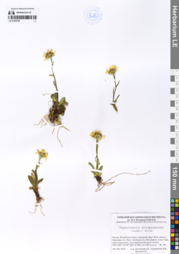
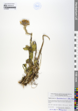
LE 01063790
Tephroseris atropurpurea (Ledeb.) Holub det. Melnikov, Denis Germanovich at 2018
Collectors: Melnikov, Denis Germanovich; Kuropatkin, Vladislav Valerievich; Lalenko Il'ya Sergeevich Field collecting number: 193. Collection date: 05.08.2018. Administrative regions: RU - Komi - Pechorskiy Rayon. Expedition: Экспедиция на Приполярный Урал (2018)Groups of specimens: Образцы сектора Восточной ЕвропыOriginal label text:Россия, Республика Коми, городской округ Инта, между горой Народная и озером Верхнее Балбанью (оз. Восьмерка), склон горы, среди курумника, мелкощебнистый грунт, во мху.
Coordinates (geographic position): 65° 3′ 59.22″ N, 60° 7′ 53.46″ E, 1324 m a.s.l.Record creation: 2020-03-15, Denis Melnikov, PhotoScan D1Citation: Specimen LE 01063790 // Virtual herbarium of Komarov Botanical Institute RAS — http://re.herbariumle.ru/01063790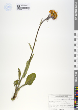
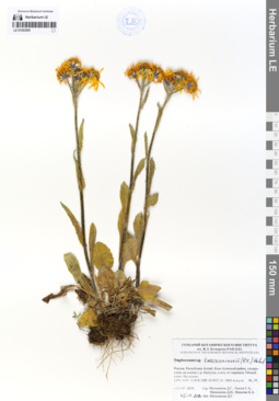
LE 01063846
Tephroseris turczaninovii (DC.) Holub det. Melnikov, Denis Germanovich at 16.07.2019
Collectors: Melnikov, Denis Germanovich; Tyusov, Grigorii Anatol'evich; Malysheva, Darya Igorevna; Ivanova, Kseniya Andreevna Field collecting number: Б-6. Collection date: 16.07.2019. Administrative regions: RU - Respublika Altay - Kosh-Agachskiy Rayon. Place of collection: плато Укок, Бертекская котловина.Expedition: Экспедиция СПбГУ и БИН на плато Укок (Республика Алтай) (07.07.2019 -07.08.2019)Groups of specimens: Образцы сектора Сибири и Дальнего Востока РоссииOriginal label text:Россия, Республика Алтай, Кош-Агачский район, плато Укок, Бертекская котловина, ЮВ склон, ерник злаково-разнотравный
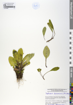
LE 01063899
Tephroseris turczaninovii (DC.) Holub det. Melnikov, Denis Germanovich at 05.05.2020
Collectors: Melnikov, Denis Germanovich; Tyusov, Grigorii Anatol'evich; Malysheva, Darya Igorevna; Ivanova, Kseniya Andreevna Field collecting number: Б-55. Collection date: 28.07.2019. Administrative regions: RU - Respublika Altay - Kosh-Agachskiy Rayon. Place of collection: плато Укок, Бертекская котловина.Expedition: Экспедиция СПбГУ и БИН на плато Укок (Республика Алтай) (07.07.2019 -07.08.2019)Groups of specimens: Образцы сектора Сибири и Дальнего Востока РоссииOriginal label text:Россия, Республика Алтай, Кош-Агачский район, плато Укок, Бертекская котловина, С склон, средняя часть, ерник кобрезиево-осоково-зеленомошны
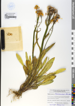
LE 01063907
Tephroseris turczaninovii (DC.) Holub det. Melnikov, Denis Germanovich at 05.05.2020
Collectors: Melnikov, Denis Germanovich; Tyusov, Grigorii Anatol'evich; Malysheva, Darya Igorevna; Ivanova, Kseniya Andreevna Field collecting number: 490. Collection date: 04.08.2019. Administrative regions: RU - Respublika Altay - Kosh-Agachskiy Rayon. Place of collection: плато Укок, Бертекская котловина.Expedition: Экспедиция СПбГУ и БИН на плато Укок (Республика Алтай) (07.07.2019 -07.08.2019)Groups of specimens: Образцы сектора Сибири и Дальнего Востока РоссииOriginal label text:Россия, Республика Алтай, Кош-Агачский район, плато Укок, Бертекская котловина, приток р. Аргамджи, сырой замшелый луг у ручья
LE 01063908
Tephroseris turczaninovii (DC.) Holub det. Melnikov, Denis Germanovich at 05.05.2020
Collectors: Melnikov, Denis Germanovich; Tyusov, Grigorii Anatol'evich; Malysheva, Darya Igorevna; Ivanova, Kseniya Andreevna Field collecting number: 439. Collection date: 01.08.2019. Administrative regions: RU - Respublika Altay - Kosh-Agachskiy Rayon. Place of collection: плато Укок, Бертекская котловина.Expedition: Экспедиция СПбГУ и БИН на плато Укок (Республика Алтай) (07.07.2019 -07.08.2019)Groups of specimens: Образцы сектора Сибири и Дальнего Востока РоссииOriginal label text:Россия, Республика Алтай, Кош-Агачский район, плато Укок, Бертекская котловина, дорога на ледник, новая морена, у валуна.
LE 01063909
Tephroseris turczaninovii (DC.) Holub det. Melnikov, Denis Germanovich at 05.05.2020
Collectors: Melnikov, Denis Germanovich; Tyusov, Grigorii Anatol'evich; Malysheva, Darya Igorevna; Ivanova, Kseniya Andreevna Field collecting number: 39. Collection date: 12.07.2019. Administrative regions: RU - Respublika Altay - Kosh-Agachskiy Rayon. Place of collection: плато Укок, Бертекская котловина.Expedition: Экспедиция СПбГУ и БИН на плато Укок (Республика Алтай) (07.07.2019 -07.08.2019)Groups of specimens: Образцы сектора Сибири и Дальнего Востока РоссииOriginal label text:Россия, Республика Алтай, Кош-Агачский район, тундро-степь на склоне у р. Калгуты, к югу от перевала Тёплый ключ. На склоне.
LE 01063910
Tephroseris turczaninovii (DC.) Holub det. Melnikov, Denis Germanovich at 08.2019
Collectors: Melnikov, Denis Germanovich; Tyusov, Grigorii Anatol'evich; Malysheva, Darya Igorevna; Ivanova, Kseniya Andreevna Field collecting number: Б-4. Collection date: 15.07.2019. Administrative regions: RU - Respublika Altay - Kosh-Agachskiy Rayon. Place of collection: плато Укок, Бертекская котловина.Expedition: Экспедиция СПбГУ и БИН на плато Укок (Республика Алтай) (07.07.2019 -07.08.2019)Groups of specimens: Образцы сектора Сибири и Дальнего Востока РоссииOriginal label text:Россия, Республика Алтай, Кош-Агачский район, плато Укок, Бертекская котловина, ЮЗ склон, разнотравно-кобрезиевое зеленомошное сообщество
LE 01103500
Tephroseris integrifolia (L.) Holub
Collectors: Georges Étienne François LECOINTE de LAVEAU Administrative regions: RU - Moscow Oblast. Place of collection: Kurbatowo.Groups of specimens: Образцы сектора Восточной ЕвропыComment:Kurbatowo, G. de Laveau in Herb. Fischer [почерк Фишера]
Рязанская губерния [теперь Московская обл.], д. Курбатово, 1810-е годы, Ж.Э.Ф. Лекуан де Лаво (Georges Étienne François LECOINTE de LAVEAU)
54.474, 38.577 (выходы известняка, известняковый карьер)
LE 01103507
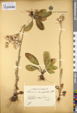
Tephroseris campestris (Retz.) Rchb.
Administrative regions: RU - Respublika Kareliya. Groups of specimens: Образцы сектора Восточной ЕвропыRecord creation: 2021-05-23, Flora of the Murmansk region, PhotoScan D2Citation: Specimen LE 01103507 // Virtual herbarium of Komarov Botanical Institute RAS — http://re.herbariumle.ru/01103507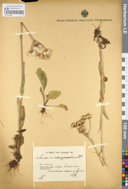
LE 01103561
Tephroseris campestris (Retz.) Rchb.
Administrative regions: RU - Respublika Kareliya. Groups of specimens: Образцы сектора Восточной ЕвропыRecord creation: 2021-05-23, Flora of the Murmansk region, PhotoScan D2Citation: Specimen LE 01103561 // Virtual herbarium of Komarov Botanical Institute RAS — http://re.herbariumle.ru/01103561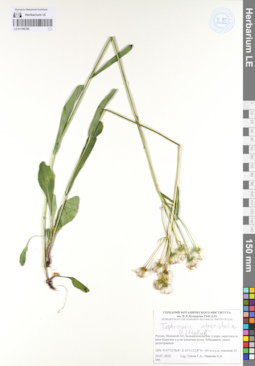
LE 01106796
Tephroseris integrifolia (L.) Holub det. Tyusov, Grigorii Anatol'evich, Ivanova K.V. at 24.07.2020
Collectors: Tyusov, Grigorii Anatol'evich; Ivanova K.V. Field collecting number: описание 22. Collection date: 24.07.2020. Administrative regions: RU-Nenetskiy Avtonomnyy Okrug - Zapolyarny Rayon. Groups of specimens: Гербарий Ботанического института им. В. Л. Комарова РАН (LE)Original label text:Россия, Ненецкой АО, Большеземельская тундра, окрестности реки Шапкина в районе впадения ручья Лабадяввож, ивняк разнотравный
GPS (географические координаты): N 67°32'28,8"; E 55°11'22,8" h (абсолютная высота) = 101 метр над уровнем мор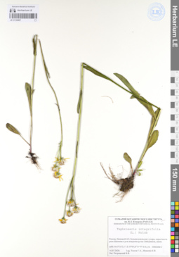
LE 01106807
Tephroseris integrifolia (L.) Holub det. Petrovsky, Vladislav Vladimirovich at 16.07.2020
Collectors: Tyusov, Grigorii Anatol'evich; Ivanova K.V. Field collecting number: описание 2. Collection date: 16.07.2020. Administrative regions: RU-Nenetskiy Avtonomnyy Okrug - Zapolyarny Rayon. Groups of specimens: Гербарий Ботанического института им. В. Л. Комарова РАН (LE)Original label text:Россия, Ненецкой АО, Большеземельская тундра, окрестности реки Шапкина в районе впадения ручья Лабадяввож, ивняк
GPS (географические координаты): N 67°33'3,1"; E 55°6'5,6" h (абсолютная высота) = 97 метров над уровнем моря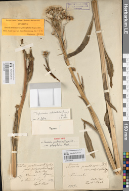
LE 01229028
Senecio pratensis var. polycephalus Regel det. Regel, Eduard August von
Additional identifications: Tephroseris subdentata (Bunge) Holub det. Chen Yaping Collectors: Maack, Richard Karlovich Collection date: 1859. Administrative regions: RU - Khabarovskiy Kray. Groups of specimens: Типовые образцы сектора Сибири и Дальнего Востока России; Соглашение Минобрнауки №075-15-2021-1056Original label text:Zwischen Kirma und Ussuri Mündung
Record creation: 2023-04-12, Марина Витальевна ЯричинаCitation: Specimen LE 01229028 // Virtual herbarium of Komarov Botanical Institute RAS — http://re.herbariumle.ru/01229028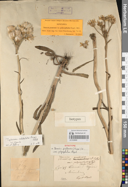
LE 01229029
Senecio pratensis var. polycephalus Regel det. Regel, Eduard August von
Additional identifications: Tephroseris subdentata (Bunge) Holub det. Chen Yaping Collectors: Maack, Richard Karlovich Collection date: 01.06.1859. Administrative regions: RU - Khabarovskiy Kray. Groups of specimens: Типовые образцы сектора Сибири и Дальнего Востока России; Соглашение Минобрнауки №075-15-2021-1056Original label text:Zwischen Kirma und Ussuri Mündung
Record creation: 2023-04-12, Марина Витальевна ЯричинаCitation: Specimen LE 01229029 // Virtual herbarium of Komarov Botanical Institute RAS — http://re.herbariumle.ru/01229029
LE 01229030
Senecio pratensis var. polycephalus Regel det. Regel, Eduard August von
Additional identifications: Tephroseris subdentata (Bunge) Holub det. Chen Yaping Collectors: Maack, Richard Karlovich Collection date: 1859. Administrative regions: RU - Khabarovskiy Kray. Groups of specimens: Типовые образцы сектора Сибири и Дальнего Востока России; Соглашение Минобрнауки №075-15-2021-1056Original label text:Kinneli
Record creation: 2023-04-12, Марина Витальевна ЯричинаCitation: Specimen LE 01229030 // Virtual herbarium of Komarov Botanical Institute RAS — http://re.herbariumle.ru/01229030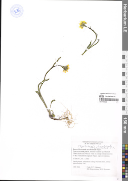
LE 01300320
Tephroseris tundricola (Tolm.) Holub det. Knjazev, Mikhail Sergeyevich at 17.09.2024
Collectors: Efimov, Peter Gennadievich; Kuropatkin, Vladislav Valerievich; Legchenko, Marina Vitaljevna Collection date: 03.07.2024. Administrative regions: RU - Yamalo-Nenetskiy Avtonomnyy Okrug - Priural'skiy Rayon. Groups of specimens: Образцы сектора Сибири и Дальнего Востока РоссииOriginal label text:Ямало-Ненецкий автономный округ, Приуральский район, южные отроги хр. Малый Пайпудынский. Около 3 км на север-северо-восток от жд станции Полярный Урал, в зарослях ерника.
67.041951, 65.113003
Yamalo-Nenets Autonomous Okrug, Priuralsky distr., railway station Poljarny Ural.