View
Add
Copy
Edit
Delete
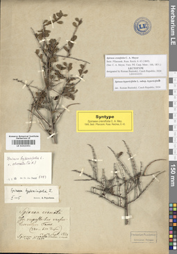
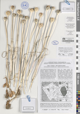
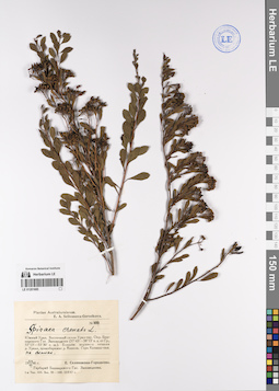
LE 01010351
Lectotype of Spiraea crenifolia C.A.Mey.
Additional identifications: Spiraea hypericifolia L. det. Pojarkova, Antonina Ivanovna at 02.1935; Spiraea hypericifolia var. obovata (Waldst. et Kit. ex Willd.) Maxim. det. Dostál, Josef at 06.10.1965; Spiraea hypericifolia ssp. hypericifolia det. Businský, Roman at 2024 Collectors: Meyer, Carl Anton von Field collecting number: 1470. Collection date: 13.09.1829. Groups of specimens: Образцы сектора КавказаOriginal label text:Spiraea crenata
Record creation: 2020-10-01, Ivan Tatanov, from old scansCitation: Specimen LE 01010351 // Virtual herbarium of Komarov Botanical Institute RAS — http://re.herbariumle.ru/01010351In rupestribus versus torrentem Terek (380-650)
12-13 Sept. 1829
Spiraea crenata Enum. cauc. casp. № 1470
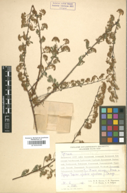
LE 01010365
Spiraea crenata L.
Groups of specimens: Образцы сектора КавказаRecord creation: 2020-10-01, Ivan Tatanov, from old scansCitation: Specimen LE 01010365 // Virtual herbarium of Komarov Botanical Institute RAS — http://re.herbariumle.ru/01010365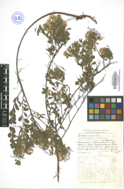
LE 01010366
Spiraea crenata L.
Groups of specimens: Образцы сектора КавказаRecord creation: 2020-10-01, Ivan Tatanov, from old scansCitation: Specimen LE 01010366 // Virtual herbarium of Komarov Botanical Institute RAS — http://re.herbariumle.ru/01010366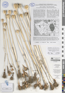
LE 01044044
Tulipa patens C. Agardh ex Schult. & Schult. f. det. Grebenjuk, Аlexey Viktorovich at 05.2020
Collectors: Grebenjuk, Аlexey Viktorovich Field collecting number: 137KU393. Collection date: 28.05.2020. Administrative regions: RU - Russian Federation; RU - Altayskiy Kray; RU - Altayskiy Kray - Blagoveshchenskiy Rayon. Топоним: озеро Кучукское. Place of collection: 4.5 км западнее дер. Нижний Кучук, в 4 км к Ю от устья р. Кучук.Expedition: Alexey V. Grebenjuk. Plantae Kulundae ()Groups of specimens: Образцы сектора Сибири и Дальнего Востока России; Соглашение Минобрнауки №075-15-2021-1056; Alexey V. Grebenjuk. Voucher specimens for chromosome countsOriginal label text:Alexey V. Grebenjuk — 2020: PLANTAE KULUNDAE
Voucher specimen for chromosome counts — Herbarium ad numeri chromosomatum
Россия, Алтайский край, Благовещенский р-н, 4.5 км западнее дер. Нижний Кучук.
Западная Сибирь, Обь-Иртышское междуречье, центральная часть Кулундинской равнины (Центральная Кулунда), окр. вост. берега оз. Кучукского, в 4 км к Ю от устья р. Кучук, закустаренная спиреей (Spiraea hypericifolia, с незначительным участием S. crenata), разнотравно-дерновиннозлаковая комплексная степь на плакоре. Сайт кустарничково-дерновиннозлаковой сухой степи с Bassia prostrata, Artemisia frigida, Koeleria macrantha, Psathyrostachys juncea на солонцеватом суглинке.
52°42'10.20" с.ш., 79°52'28.40" в.д., 107 м н.у.м.
RUSSIAN FEDERATION, Altai Krai, Blagoveshchensky District, 4.5 km W of the village of Nizhny Kuchuk.
SW SIBERIA, Ob—Irtysh interfluve, Central part of the Kulunda Steppe, vicinities of the eastern shore of Kuchukskoye Lake, 4 km S of the mouth of the Kuchuk River, xerophyte herbaceous–dwarf semishrub site on sandy solonetzic loam (with Bassia prostrata, Artemisia frigida, Koeleria macrantha, Psathyrostachys juncea) in grass community of shrub complex steppe (Spiraea hypericifolia, S. crenata).
N52°42'10.20", E79°52'28.40", Alt. 107 m a.s.l.
№ 137KU393 Coll.: 28 Majo 2020 Alexey V. Grebenjuk
Rossia, Prov. Altajensis (Barnaul), distr. Blagovesczhenka, 4.5 km ad occidentalem a pagо Nizhnij Kuczuk;
Siberia Occidentalis, Terra Ob—Irtisch interfluvia, Kulunda Centralis, ad placorem prope ripam orientalem lacum salsum Kuczukskoje, 4 km australem ad ostium fluminis Kuczuk, steppa fruticosa (cum Spiraea hypericifolia, S. crenata ex min. parte) complexa – variiherbosa xerophytica et caespitoso-graminosa; ass. Bassia prostrata, Artemisia frigida, Koeleria macrantha, Psathyrostachys juncea (steppa subargilloso-subsalsuginosa subdeserta). 52°42'10.20" lat.bor., 79°52'28.40" long.or., 107 m s.m.
Some bulbs removed in situ et in vivo for sprouting
Coll. nº 20X-137KU
May 28, 2020
Alexey V. Grebenjuk (LE)
Some root-tips removed ex situ 22 Sept. 2020 at 10:30 for chromosome counts
Specimen nº 20X-137KU
fixed in acetic alcohol (1:3) at 14:30 after 4h 8-hydroxyquinoline exposure
Alexey V. Grebenjuk (LE)
Somatic cells of specimen nº 20X-137KU contain 2n=24 chromosomes
February 2021
Tatyana V. Pankova (NS)
LE 01044045
Tulipa patens C. Agardh ex Schult. & Schult. f. det. Grebenjuk, Аlexey Viktorovich at 05.2020
Collectors: Grebenjuk, Аlexey Viktorovich Field collecting number: 137KU392. Collection date: 28.05.2020. Administrative regions: RU - Russian Federation; RU - Altayskiy Kray; RU - Altayskiy Kray - Blagoveshchenskiy Rayon. Топоним: озеро Кучукское. Place of collection: 4.5 км западнее дер. Нижний Кучук, в 4 км к Ю от устья р. Кучук.Expedition: Alexey V. Grebenjuk. Plantae Kulundae ()Groups of specimens: Образцы сектора Сибири и Дальнего Востока России; Соглашение Минобрнауки №075-15-2021-1056; Alexey V. Grebenjuk. Voucher specimens for chromosome countsOriginal label text:Alexey V. Grebenjuk — 2020: PLANTAE KULUNDAE
Voucher specimen for chromosome counts — Herbarium ad numeri chromosomatum
Россия, Алтайский край, Благовещенский р-н, 4.5 км западнее дер. Нижний Кучук.
Западная Сибирь, Обь-Иртышское междуречье, центральная часть Кулундинской равнины (Центральная Кулунда), окр. вост. берега оз. Кучукского, в 4 км к Ю от устья р. Кучук, закустаренная спиреей (Spiraea hypericifolia, с незначительным участием S. crenata), разнотравно-дерновиннозлаковая комплексная степь на плакоре. Сайт кустарничково-дерновиннозлаковой сухой степи с Bassia prostrata, Artemisia frigida, Koeleria macrantha, Psathyrostachys juncea на солонцеватом суглинке.
52°42'10.20" с.ш., 79°52'28.40" в.д., 107 м н.у.м.
RUSSIAN FEDERATION, Altai Krai, Blagoveshchensky District, 4.5 km W of the village of Nizhny Kuchuk.
SW SIBERIA, Ob—Irtysh interfluve, Central part of the Kulunda Steppe, vicinities of the eastern shore of Kuchukskoye Lake, 4 km S of the mouth of the Kuchuk River, xerophyte herbaceous–dwarf semishrub site on sandy solonetzic loam (with Bassia prostrata, Artemisia frigida, Koeleria macrantha, Psathyrostachys juncea) in grass community of shrub complex steppe (Spiraea hypericifolia, S. crenata).
N52°42'10.20", E79°52'28.40", Alt. 107 m a.s.l.
№ 137KU392 Coll.: 28 Majo 2020 Alexey V. Grebenjuk
Rossia, Prov. Altajensis (Barnaul), distr. Blagovesczhenka, 4.5 km ad occidentalem a pagо Nizhnij Kuczuk;
Siberia Occidentalis, Terra Ob—Irtisch interfluvia, Kulunda Centralis, ad placorem prope ripam orientalem lacum salsum Kuczukskoje, 4 km australem ad ostium fluminis Kuczuk, steppa fruticosa (cum Spiraea hypericifolia, S. crenata ex min. parte) complexa – variiherbosa xerophytica et caespitoso-graminosa; ass. Bassia prostrata, Artemisia frigida, Koeleria macrantha, Psathyrostachys juncea (steppa subargilloso-subsalsuginosa subdeserta). 52°42'10.20" lat.bor., 79°52'28.40" long.or., 107 m s.m.
Some bulbs removed in situ et in vivo for sprouting
Coll. nº 20X-137KU
May 28, 2020
Alexey V. Grebenjuk (LE)
Some root-tips removed ex situ 22 Sept. 2020 at 10:30 for chromosome counts
Specimen nº 20X-137KU
fixed in acetic alcohol (1:3) at 14:30 after 4h 8-hydroxyquinoline exposure
Alexey V. Grebenjuk (LE)
Somatic cells of specimen nº 20X-137KU contain 2n=24 chromosomes
February 2021
Tatyana V. Pankova (NS)
LE 01045050
Holotype of Goniolimon speciosum (L.) Boiss. var. inerme A.V. Grebenjuk det. Grebenjuk, Аlexey Viktorovich at 11.2023
Collectors: Grebenjuk, Аlexey Viktorovich Field collecting number: adHFR14sn. Collection date: 13.07.2014. Administrative regions: RU - Russian Federation; RU - Altayskiy Kray; RU - Altayskiy Kray - Blagoveshchenskiy Rayon. Subregion: Благовещенский район. Топоним: озеро Кучукское. Place of collection: 4.5 км западнее дер. Нижний Кучук, восточный берег оз. Кучукское, в 4 км южнее устья р. Кучук.Expedition: Alexey V. Grebenjuk. Plantae Kulundae ()Groups of specimens: Типовые образцы сектора Сибири и Дальнего Востока России; Образцы сектора Сибири и Дальнего Востока России; Соглашение Минобрнауки №075-15-2021-1056Original label text:Alexey V. Grebenjuk — 2014: Plantae Kulundae
Россия, Алтайский край, Благовещенский р-н, 4.5 км западнее дер. Нижний Кучук. Западная Сибирь, Обь-Иртышское междуречье, центральная часть Кулундинской равнины (Центральная Кулунда), окр. вост. берега оз. Кучукского, в 4 км к Ю от устья р. Кучук, закустаренная спиреей (Spiraea hypericifolia, с незначительным участием S. crenata), разнотравно-дерновиннозлаковая комплексная степь на плакоре, вдоль куртин кустарников.
52°42'15.12" с.ш., 79°52'34.21" в.д., 108 м н.у.м.
Rossia, Prov. Altajensis (Barnaul), distr. Blagovesczhenka, 4.5 km ad occidentalem a pagо Nizhnij Kuczuk; Siberia Occidentalis, Terra Ob—Irtisch interfluvia, Kulunda Centralis, ad placorem prope ripam orientalem lacum salsum Kuczukskoje, 4 km australem ad ostium fluminis Kuczuk, steppa friticosa (cum Spiraea hypericifolia, S. crenata ex min. parte) complexa – variiherbosa xerophytica et caespitoso-graminosa, inter frutices.
52°42'15.12" lat.bor., 79°52'34.21" long.or., 108 m s.m.
RUSSIAN FEDERATION, Altai Krai, Blagoveshchensky District, 4.5 km W of the village of Nizhny Kuchuk.
SW SIBERIA, Ob—Irtysh interfluve, Central part of the Kulunda Steppe, vicinities of the eastern shore of Kuchukskoye Lake, 4 km S of the mouth of the Kuchuk River, xerophyte herbaceous site in grass community of shrub complex steppe, among shrublets (Spiraea hypericifolia, S. crenata). N52°42'15.12", E79°52'34.21", Alt. 108 m a.s.l.№ adHFR14sn Coll.: 13 Julio 2014 Alexey V. Grebenjuk
LE 01045051
Isotype of Goniolimon speciosum (L.) Boiss. var. inerme A.V. Grebenjuk det. Grebenjuk, Аlexey Viktorovich at 11.2023
Collectors: Grebenjuk, Аlexey Viktorovich Field collecting number: adHFR14sn. Collection date: 13.07.2014. Administrative regions: RU - Russian Federation; RU - Altayskiy Kray; RU - Altayskiy Kray - Blagoveshchenskiy Rayon. Subregion: Благовещенский район. Топоним: озеро Кучукское. Place of collection: 4.5 км западнее дер. Нижний Кучук, восточный берег оз. Кучукское, в 4 км южнее устья р. Кучук.Expedition: Alexey V. Grebenjuk. Plantae Kulundae ()Groups of specimens: Типовые образцы сектора Сибири и Дальнего Востока России; Образцы сектора Сибири и Дальнего Востока России; Соглашение Минобрнауки №075-15-2021-1056Original label text:Alexey V. Grebenjuk — 2014: Plantae Kulundae
Россия, Алтайский край, Благовещенский р-н, 4.5 км западнее дер. Нижний Кучук. Западная Сибирь, Обь-Иртышское междуречье, центральная часть Кулундинской равнины (Центральная Кулунда), окр. вост. берега оз. Кучукского, в 4 км к Ю от устья р. Кучук, закустаренная спиреей (Spiraea hypericifolia, с незначительным участием S. crenata), разнотравно-дерновиннозлаковая комплексная степь на плакоре, вдоль куртин кустарников.
52°42'15.12" с.ш., 79°52'34.21" в.д., 108 м н.у.м.
Rossia, Prov. Altajensis (Barnaul), distr. Blagovesczhenka, 4.5 km ad occidentalem a pagо Nizhnij Kuczuk; Siberia Occidentalis, Terra Ob—Irtisch interfluvia, Kulunda Centralis, ad placorem prope ripam orientalem lacum salsum Kuczukskoje, 4 km australem ad ostium fluminis Kuczuk, steppa friticosa (cum Spiraea hypericifolia, S. crenata ex min. parte) complexa – variiherbosa xerophytica et caespitoso-graminosa, inter frutices.
52°42'15.12" lat.bor., 79°52'34.21" long.or., 108 m s.m.
RUSSIAN FEDERATION, Altai Krai, Blagoveshchensky District, 4.5 km W of the village of Nizhny Kuchuk.
SW SIBERIA, Ob—Irtysh interfluve, Central part of the Kulunda Steppe, vicinities of the eastern shore of Kuchukskoye Lake, 4 km S of the mouth of the Kuchuk River, xerophyte herbaceous site in grass community of shrub complex steppe, among shrublets (Spiraea hypericifolia, S. crenata). N52°42'15.12", E79°52'34.21", Alt. 108 m a.s.l.№ adHFR14sn Coll.: 13 Julio 2014 Alexey V. Grebenjuk
LE 01045052
Isotype of Goniolimon speciosum (L.) Boiss. var. inerme A.V. Grebenjuk det. Grebenjuk, Аlexey Viktorovich at 11.2023
Collectors: Grebenjuk, Аlexey Viktorovich Field collecting number: adHFR14sn. Collection date: 13.07.2014. Administrative regions: RU - Russian Federation; RU - Altayskiy Kray; RU - Altayskiy Kray - Blagoveshchenskiy Rayon. Subregion: Благовещенский район. Топоним: озеро Кучукское. Place of collection: 4.5 км западнее дер. Нижний Кучук, восточный берег оз. Кучукское, в 4 км южнее устья р. Кучук.Expedition: Alexey V. Grebenjuk. Plantae Kulundae ()Groups of specimens: Типовые образцы сектора Сибири и Дальнего Востока России; Образцы сектора Сибири и Дальнего Востока России; Соглашение Минобрнауки №075-15-2021-1056Original label text:Alexey V. Grebenjuk — 2014: Plantae Kulundae
Россия, Алтайский край, Благовещенский р-н, 4.5 км западнее дер. Нижний Кучук. Западная Сибирь, Обь-Иртышское междуречье, центральная часть Кулундинской равнины (Центральная Кулунда), окр. вост. берега оз. Кучукского, в 4 км к Ю от устья р. Кучук, закустаренная спиреей (Spiraea hypericifolia, с незначительным участием S. crenata), разнотравно-дерновиннозлаковая комплексная степь на плакоре, вдоль куртин кустарников.
52°42'15.12" с.ш., 79°52'34.21" в.д., 108 м н.у.м.
Rossia, Prov. Altajensis (Barnaul), distr. Blagovesczhenka, 4.5 km ad occidentalem a pagо Nizhnij Kuczuk; Siberia Occidentalis, Terra Ob—Irtisch interfluvia, Kulunda Centralis, ad placorem prope ripam orientalem lacum salsum Kuczukskoje, 4 km australem ad ostium fluminis Kuczuk, steppa friticosa (cum Spiraea hypericifolia, S. crenata ex min. parte) complexa – variiherbosa xerophytica et caespitoso-graminosa, inter frutices.
52°42'15.12" lat.bor., 79°52'34.21" long.or., 108 m s.m.
RUSSIAN FEDERATION, Altai Krai, Blagoveshchensky District, 4.5 km W of the village of Nizhny Kuchuk.
SW SIBERIA, Ob—Irtysh interfluve, Central part of the Kulunda Steppe, vicinities of the eastern shore of Kuchukskoye Lake, 4 km S of the mouth of the Kuchuk River, xerophyte herbaceous site in grass community of shrub complex steppe, among shrublets (Spiraea hypericifolia, S. crenata). N52°42'15.12", E79°52'34.21", Alt. 108 m a.s.l.№ adHFR14sn Coll.: 13 Julio 2014 Alexey V. Grebenjuk
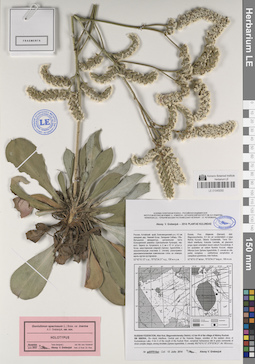
LE 01201685
Spiraea crenata L. det. Selivanova-Gorodkova, Elena Alexandrovna at 29.07.1946
Collectors: Selivanova-Gorodkova, Elena Alexandrovna Field collecting number: 1001. Collection date: 29.07.1946. Administrative regions: RU - Bashkortostan. Groups of specimens: Образцы сектора Восточной Европы; Соглашение Минобрнауки №075-15-2021-1056; Флора Урала и прилегающих территорий (проект); Гербарий Башкирского Заповедника; Plantae australiuralenses. E. A. Selivanova-Gorodkova.Original label text:Южный Урал. Восточный склон Урал-тау. Окрестности Башкирского Государственного Заповедника (57°43′ - 58°12′ восточной долготы от Гринвича, 53° 15′ - 53° 30′ северной широты). Бассейн верхнего течения реки Урала, правобережье реки Кизила. Гора Казмаш-таш, на скалах.
Record creation: 2022-11-18, Denis Melnikov, PhotoScan D2.Citation: Specimen LE 01201685 // Virtual herbarium of Komarov Botanical Institute RAS — http://re.herbariumle.ru/01201685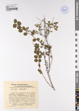
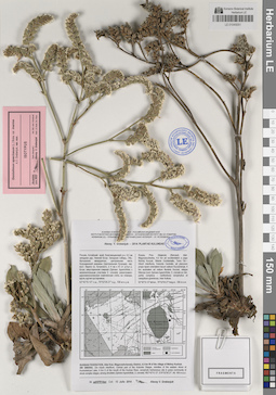
LE 01201689
Spiraea crenata L. det. Selivanova-Gorodkova, Elena Alexandrovna at 18.08.1945
Collectors: Selivanova-Gorodkova, Elena Alexandrovna Field collecting number: 54. Collection date: 18.08.1945. Administrative regions: RU - Bashkortostan - Burzyanskiy Rayon. Топоним: Башгосзаповедник (Башкирский государственный природный заповедник). Groups of specimens: Образцы сектора Восточной Европы; Соглашение Минобрнауки №075-15-2021-1056; Флора Урала и прилегающих территорий (проект); Гербарий Башкирского Заповедника; Plantae australiuralenses. E. A. Selivanova-Gorodkova.Original label text:Южный Урал. Башкирский Государственный Заповедник (57°43' -- 58°12' в. д. от Гринвича, 53°15' -- 53°30' с. ш.). Зона контакта Южный Крака и Урал-тау. Бассейн верхнего течения реки Белой. Квадрат 29. Верховье реки Улажи. Березово-черемухово-ольховая урема. Обнажения сланца по южному коренному берегу реки Улажи. Оп [?] 54.
Coordinates (geographic position): 53° 27′ 39.6″ N, 58° 3′ 21.43″ E ±1000 mRecord creation: 2022-11-18, Denis Melnikov, PhotoScan D2.Citation: Specimen LE 01201689 // Virtual herbarium of Komarov Botanical Institute RAS — http://re.herbariumle.ru/01201689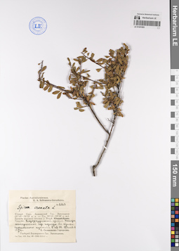
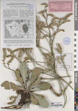
LE 01201693
Spiraea crenata L. det. Selivanova-Gorodkova, Elena Alexandrovna at 19.09.1946
Collectors: Selivanova-Gorodkova, Elena Alexandrovna Field collecting number: 2876. Collection date: 19.09.1946. Administrative regions: RU - Bashkortostan - Burzyanskiy Rayon. Топоним: Башгосзаповедник (Башкирский государственный природный заповедник). Groups of specimens: Образцы сектора Восточной Европы; Соглашение Минобрнауки №075-15-2021-1056; Флора Урала и прилегающих территорий (проект); Plantae australiuralenses. E. A. Selivanova-Gorodkova.; Гербарий Башкирского ЗаповедникаOriginal label text:Южный Урал. Башкирский Государственный Заповедник (57°43' -- 58°12' в. д. от Гринвича, 53°15' -- 53°30' с. ш.). Бассейн верхнего течения реки Белой. Урал-тау. Водораздельный хребет. Выходы материнской горной породы близ триангуляционного пункта в квадрате 114. 880 метров абсолютной высоты.
Coordinates (geographic position): 53° 21′ 10.69″ N, 58° 8′ 0.75″ E ±1000 m 880 m a.s.l.Record creation: 2022-11-18, Denis Melnikov, PhotoScan D2.Citation: Specimen LE 01201693 // Virtual herbarium of Komarov Botanical Institute RAS — http://re.herbariumle.ru/01201693