View
Add
Copy
Edit
Delete
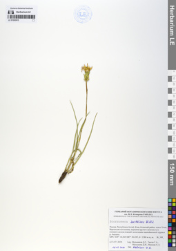
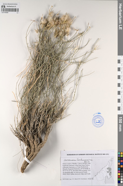
LE 01063915
Scorzonera austriaca Willd. det. Melnikov, Denis Germanovich at 06.05.2020
Collectors: Melnikov, Denis Germanovich; Tyusov Grigorii Anatol'evich; Malysheva Darya Igorevna; Ivanova Kseniya Andreevna Field collecting number: 369. Collection date: 27.07.2019. Administrative regions: RU - Respublika Altay - Kosh-Agachskiy Rayon. Place of collection: плато Укок, Бертекская котловина.Expedition: Экспедиция СПбГУ и БИН на плато Укок (Республика Алтай) (07.07.2019 -07.08.2019)Groups of specimens: Образцы сектора Сибири и Дальнего Востока РоссииOriginal label text:Россия, Республика Алтай, Кош-Агачский район, плато Укок, Бертекская котловина, вершина крутого каменистого степного склона южной экспозиции надпойменной террасы р. Акалаха.
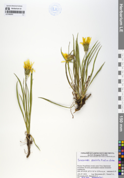
LE 01063916
Scorzonera radiata Fisch. ex Ledeb. det. Melnikov, Denis Germanovich at 06.05.2020
Collectors: Melnikov, Denis Germanovich; Tyusov Grigorii Anatol'evich; Malysheva Darya Igorevna; Ivanova Kseniya Andreevna Field collecting number: Б-59. Collection date: 29.07.2019. Administrative regions: RU - Respublika Altay - Kosh-Agachskiy Rayon. Place of collection: плато Укок, Бертекская котловина.Expedition: Экспедиция СПбГУ и БИН на плато Укок (Республика Алтай) (07.07.2019 -07.08.2019)Groups of specimens: Образцы сектора Сибири и Дальнего Востока РоссииOriginal label text:Россия, Республика Алтай, Кош-Агачский район, плато Укок, Бертекская котловина, В склон, разнотравно-злаково-полынное сообщество
LE 01070885
Scorzonera kirpicznikovii Lipsch.
Groups of specimens: Образцы сектора КавказаRecord creation: 2020-10-01, Ivan Tatanov, from old scansCitation: Specimen LE 01070885 // Virtual herbarium of Komarov Botanical Institute RAS — http://re.herbariumle.ru/01070885
LE 01070886
Scorzonera kirpicznikovii Lipsch.
Groups of specimens: Образцы сектора КавказаRecord creation: 2020-10-01, Ivan Tatanov, from old scansCitation: Specimen LE 01070886 // Virtual herbarium of Komarov Botanical Institute RAS — http://re.herbariumle.ru/01070886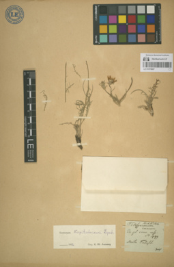
LE 01070887
Scorzonera kirpicznikovii Lipsch.
Groups of specimens: Образцы сектора КавказаRecord creation: 2020-10-01, Ivan Tatanov, from old scansCitation: Specimen LE 01070887 // Virtual herbarium of Komarov Botanical Institute RAS — http://re.herbariumle.ru/01070887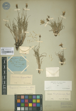
LE 01070888
Scorzonera kirpicznikovii Lipsch.
Groups of specimens: Образцы сектора КавказаRecord creation: 2020-10-01, Ivan Tatanov, from old scansCitation: Specimen LE 01070888 // Virtual herbarium of Komarov Botanical Institute RAS — http://re.herbariumle.ru/01070888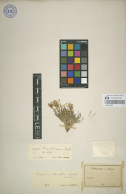
LE 01070889
Scorzonera kirpicznikovii Lipsch.
Groups of specimens: Образцы сектора КавказаRecord creation: 2020-10-01, Ivan Tatanov, from old scansCitation: Specimen LE 01070889 // Virtual herbarium of Komarov Botanical Institute RAS — http://re.herbariumle.ru/01070889
LE 01070890
Scorzonera kirpicznikovii Lipsch.
Groups of specimens: Образцы сектора КавказаRecord creation: 2020-10-01, Ivan Tatanov, from old scansCitation: Specimen LE 01070890 // Virtual herbarium of Komarov Botanical Institute RAS — http://re.herbariumle.ru/01070890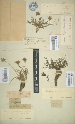
LE 01070891
Scorzonera kirpicznikovii Lipsch.
Groups of specimens: Образцы сектора КавказаRecord creation: 2020-10-01, Ivan Tatanov, from old scansCitation: Specimen LE 01070891 // Virtual herbarium of Komarov Botanical Institute RAS — http://re.herbariumle.ru/01070891
LE 01070892
Scorzonera kirpicznikovii Lipsch.
Groups of specimens: Образцы сектора КавказаRecord creation: 2020-10-01, Ivan Tatanov, from old scansCitation: Specimen LE 01070892 // Virtual herbarium of Komarov Botanical Institute RAS — http://re.herbariumle.ru/01070892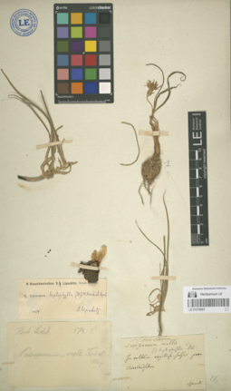
LE 01070893
Scorzonera mollis var. leptophylla
Groups of specimens: Образцы сектора КавказаRecord creation: 2020-10-01, Ivan Tatanov, from old scansCitation: Specimen LE 01070893 // Virtual herbarium of Komarov Botanical Institute RAS — http://re.herbariumle.ru/01070893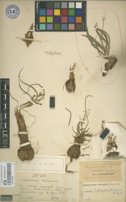
LE 01070894
Scorzonera mollis var. leptophylla
Groups of specimens: Образцы сектора КавказаRecord creation: 2020-10-01, Ivan Tatanov, from old scansCitation: Specimen LE 01070894 // Virtual herbarium of Komarov Botanical Institute RAS — http://re.herbariumle.ru/01070894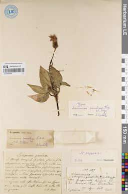
LE 01072974
Specimen originale of Scorzonera paradoxa Fisch. & C.A. Mey.
Collectors: Szovits (Szowitz, Szovitz), Johann Nepomuk Field collecting number: 107. Collection date: 17.04.1828. Administrative regions: IR - Iran (Islamic Republic of). Groups of specimens: Образцы сектора Кавказа; Типовые образцы сектора Кавказа; Соглашение Минобрнауки №075-15-2021-1056Record creation: 2021-12-02, Ivan Tatanov, PhotoScan D2Citation: Specimen LE 01072974 // Virtual herbarium of Komarov Botanical Institute RAS — http://re.herbariumle.ru/01072974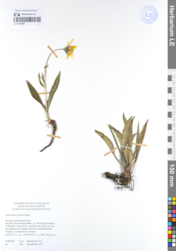
LE 01107888
Scorzonera glabra Rupr. det. Valuyskikh, Ol'ga Yevgen'yevna at 06.08.2018
Collectors: Valuyskikh, Ol'ga Yevgen'yevna Collection date: 06.08.2018. Administrative regions: RU - Komi. Subregion: Троицко-Печорский район. Place of collection: хр. Поясовый Камень, г. Печерья-Таляхчахль, средняя часть ЮЗ склона..Groups of specimens: Гербарий Ботанического института им. В. Л. Комарова РАН (LE); Гербарий Института биологии Коми научного Центра Уральского отделения РАН (SYKO)Original label text:Гербарий Ботанического института им. В. Л. Комарова РАН
Гербарий Института биологии Коми научного Центра Уральского отделения РАН (SYKO)
Scorzonera glabra Rupr.
Россия, Республика Коми, Троицко-Печорский район, хр. Поясовый Камень, г. Печерья-Таляхчахль, средняя часть ЮЗ склона.
Кустарничково-травяно-мохово-лишайниковая тундра, по каменным уступам.
62°8'51,3" с. ш., 59°24'0,8" в. д., 780 м над ур. м.
06.08.2018
Leg. Валуйских О.Е.
Det. Валуйских О.Е.
Habitat / plant community in location of collecting: Кустарничково-травяно-мохово-лишайниковая тундра, по каменным уступам.Coordinates (geographic position): 62° 8′ 51.3″ N, 59° 24′ 0.8″ E, 780 m a.s.l.Record creation: 2021-03-20, Denis Melnikov, PhotoScan D2Citation: Specimen LE 01107888 // Virtual herbarium of Komarov Botanical Institute RAS — http://re.herbariumle.ru/01107888Гербарий Института биологии Коми научного Центра Уральского отделения РАН (SYKO)
Scorzonera glabra Rupr.
Россия, Республика Коми, Троицко-Печорский район, хр. Поясовый Камень, г. Печерья-Таляхчахль, средняя часть ЮЗ склона.
Кустарничково-травяно-мохово-лишайниковая тундра, по каменным уступам.
62°8'51,3" с. ш., 59°24'0,8" в. д., 780 м над ур. м.
06.08.2018
Leg. Валуйских О.Е.
Det. Валуйских О.Е.
LE 01193587
Scorzonera tortuosissima Boiss. det. Byalt, Vyacheslav Vyacheslavovich
Administrative regions: OM - Oman. Groups of specimens: Образцы общего сектора; Соглашение Минобрнауки №075-15-2021-1056Record creation: 2023-03-22, Larisa Orlova, PhotoScan D2.Citation: Specimen LE 01193587 // Virtual herbarium of Komarov Botanical Institute RAS — http://re.herbariumle.ru/01193587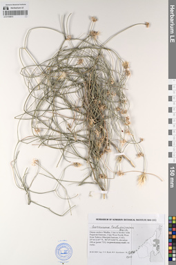
LE 01193613
Scorzonera tortuosissima Boiss. det. Byalt, Vyacheslav Vyacheslavovich
Administrative regions: OM - Oman. Groups of specimens: Образцы общего сектора; Соглашение Минобрнауки №075-15-2021-1056Record creation: 2023-03-22, Larisa Orlova, PhotoScan D2.Citation: Specimen LE 01193613 // Virtual herbarium of Komarov Botanical Institute RAS — http://re.herbariumle.ru/01193613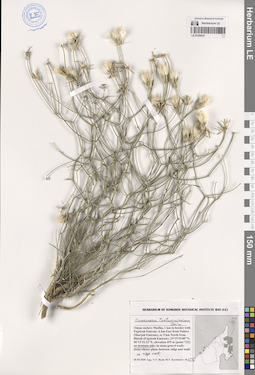
LE 01259337
Scorzonera tortuosissima Boiss. det. Byalt, Vyacheslav Vyacheslavovich
Collectors: Byalt, Vyacheslav Vyacheslavovich; Korshunov, Mikhail Vladimirovich Field collecting number: 1236. Collection date: 28.03.2020. Administrative regions: OM - Oman. Place of collection: Oman enclave Madha, 1 km to border with Fujairah Emirate, 6 km East from Nahwa (Sharjah Emirate), or 5 km North from Bitnah (Fujairah Emirate) [point 722]: on mountain side near ridge crest.Groups of specimens: Образцы общего сектора; Соглашение Минобрнауки №075-15-2021-1056; Бялт В.В.: Флора ФуджейрыOriginal label text: Oman enclave Madha, 1 km to border with Fujairah Emirate, 6 km East from Nahwa (Sharjah Emirate), or 5 km North from Bitnah (Fujairah Emirate). 25°15'29.80"N, 56°13'32.22"E, elevation 455 m [point 722]: on montain side near ridge crest, 28 III 2020, fr., V.V. Byalt, M.V. Korshunov 1236