View
Add
Copy
Edit
Delete
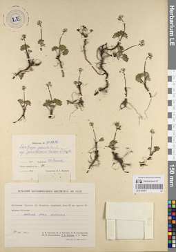
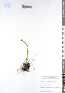
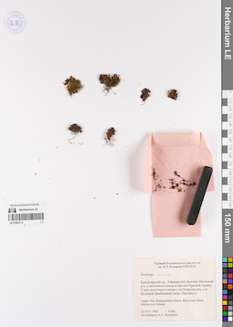
LE 01078874
Saxifraga sibirica L. det. Melnikov, Denis Germanovich at 20.07.2019
Collectors: Melnikov, Denis Germanovich; Tyusov Grigorii Anatol'evich; Malysheva Darya Igorevna; Ivanova Kseniya Andreevna Field collecting number: 281. Collection date: 20.07.2019. Administrative regions: RU - Respublika Altay - Kosh-Agachskiy Rayon. Expedition: Экспедиция СПбГУ и БИН на плато Укок (Республика Алтай) (07.07.2019 -07.08.2019)Groups of specimens: Образцы сектора Сибири и Дальнего Востока РоссииOriginal label text:Россия, Республика Алтай, Кош-Агачский район, плато Укок, Бертекская котловина, вершина склона холма, тундра с ерником.
GPS: N49° 18.329' Е87° 25.449’, h= 2453 м н.у.м. № 281
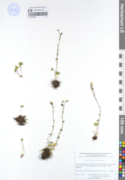
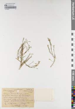
LE 01078875
Saxifraga melaleuca Fisch. ex Spreng. det. Melnikov, Denis Germanovich at 20.07.2019
Collectors: Melnikov, Denis Germanovich; Tyusov Grigorii Anatol'evich; Malysheva Darya Igorevna; Ivanova Kseniya Andreevna Field collecting number: 297. Collection date: 20.07.2019. Administrative regions: RU - Respublika Altay - Kosh-Agachskiy Rayon. Expedition: Экспедиция СПбГУ и БИН на плато Укок (Республика Алтай) (07.07.2019 -07.08.2019)Groups of specimens: Образцы сектора Сибири и Дальнего Востока РоссииOriginal label text:Россия, Республика Алтай, Кош-Агачский район, плато Укок, Бертекская котловина, в ернике на горном склоне. К юго-востоку от оз. Кальджин-Коль-Бас.
GPS: N49° 17.852' Е87° 24.193', h= 2500 м н.у.м. № 297
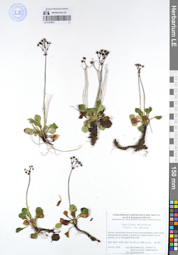
LE 01078879
Saxifraga macrocalyx Tolm. det. Melnikov, Denis Germanovich at 28.01.2020
Collectors: Melnikov, Denis Germanovich; Tyusov Grigorii Anatol'evich; Malysheva Darya Igorevna; Ivanova Kseniya Andreevna Field collecting number: Б-44. Collection date: 26.07.2019. Administrative regions: RU - Respublika Altay - Kosh-Agachskiy Rayon. Expedition: Экспедиция СПбГУ и БИН на плато Укок (Республика Алтай) (07.07.2019 -07.08.2019)Groups of specimens: Образцы сектора Сибири и Дальнего Востока РоссииOriginal label text:Россия, Республика Алтай, плато Укок, Бертекская котловина, выположенныя вершина, разнотравно-кобрезиевое сообщество
GPS: 49°19’07”; 87°28’18”, h=2434 м н.у.м. описание Б-44

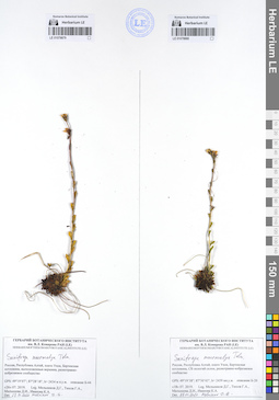
LE 01078880
Saxifraga macrocalyx Tolm. det. Melnikov, Denis Germanovich at 28.01.2020
Collectors: Melnikov, Denis Germanovich; Tyusov Grigorii Anatol'evich; Malysheva Darya Igorevna; Ivanova Kseniya Andreevna Field collecting number: Б-20. Collection date: 18.07.2019. Administrative regions: RU - Respublika Altay - Kosh-Agachskiy Rayon. Expedition: Экспедиция СПбГУ и БИН на плато Укок (Республика Алтай) (07.07.2019 -07.08.2019)Groups of specimens: Образцы сектора Сибири и Дальнего Востока РоссииOriginal label text:Россия, Республика Алтай, плато Укок, Бертекская котловина, СВ пологий склон, разнотравно-кобрезиевое сообщетво
GPS: 49° 19’38”; 87°30’43”, h= 2459 мн.у.м. описание Б-20
LE 01078881
Saxifraga macrocalyx Tolm. det. Melnikov, Denis Germanovich at 28.01.2020
Collectors: Melnikov, Denis Germanovich; Tyusov Grigorii Anatol'evich; Malysheva Darya Igorevna; Ivanova Kseniya Andreevna Field collecting number: Б-40. Collection date: 22.07.2019. Administrative regions: RU - Respublika Altay - Kosh-Agachskiy Rayon. Expedition: Экспедиция СПбГУ и БИН на плато Укок (Республика Алтай) (07.07.2019 -07.08.2019)Groups of specimens: Образцы сектора Сибири и Дальнего Востока РоссииOriginal label text:Россия, Республика Алтай, плато Укок, Бертекская котловина, С склон к озёрной котловине, ерник разнотравно-кобрезиевый зеленомошный
GPS: 49°18’43”; 87°29’23”, h= 2441 м н.у.м. описание Б-40
LE 01082706
Saxifraga cespitosa L.
Collectors: Sey, I. Collection date: 23.05.1960. Administrative regions: RU - Krasnoyarskiy Kray - Taymyrsky Dolgano-Nenetsky District. Groups of specimens: Образцы сектора Сибири и Дальнего Востока РоссииOriginal label text:Красноярский кр., Таймырский Долгано-Ненецкий р-н, у восточного входа в пролив Красной Армии. У юго-восточного конца о-ва Комсомолец, о-в Большой Диабазовый (море Лаптевых)
Laptev Sea, Komsomolets Island, Red Army Strait, Diabasovye Islands
LE 01082708
Saxifraga cernua L.
Collectors: Sey, I. Collection date: 23.05.1960. Administrative regions: RU - Krasnoyarskiy Kray - Taymyrsky Dolgano-Nenetsky District. Groups of specimens: Образцы сектора Сибири и Дальнего Востока РоссииOriginal label text:Красноярский кр., Таймырский Долгано-Ненецкий р-н, у восточного входа в пролив Красной Армии. У юго-восточного конца о-ва Комсомолец, о-в Большой Диабазовый (море Лаптевых)
Laptev Sea, Komsomolets Island, Red Army Strait, Diabasovye Islands
LE 01082711
Saxifraga oppositifolia L.
Collectors: Sey, I. Collection date: 23.05.1968. Administrative regions: RU - Krasnoyarskiy Kray - Taymyrsky Dolgano-Nenetsky District. Groups of specimens: Образцы сектора Сибири и Дальнего Востока РоссииOriginal label text:Красноярский кр., Таймырский Долгано-Ненецкий р-н, у восточного входа в пролив Красной Армии. У юго-восточного конца о-ва Комсомолец, о-в Большой Диабазовый (море Лаптевых)
Laptev Sea, Komsomolets Island, Red Army Strait, Diabasovye Islands
LE 01082712
Saxifraga cernua L.
Collectors: Sey, I. Collection date: 23.05.1960. Administrative regions: RU - Krasnoyarskiy Kray - Taymyrsky Dolgano-Nenetsky District. Groups of specimens: Образцы сектора Сибири и Дальнего Востока РоссииOriginal label text:Красноярский кр., Таймырский Долгано-Ненецкий р-н, у восточного входа в пролив Красной Армии. У юго-восточного конца о-ва Комсомолец, о-в Большой Диабазовый (море Лаптевых)
Laptev Sea, Komsomolets Island, Red Army Strait, Diabasovye Islands
LE 01085367
Petrorhagia saxifraga (L.) Link det. Tzvelev, Nikolai Nikolaievich at 2009
Collection date: 02.08.2009. Administrative regions: BY - Minsk Oblast. Subregion: Минский р-н. Place of collection: г. Минск, Центральный ботанический сад НАН Беларуси. Участок полезных травянистых растений..Groups of specimens: Образцы сектора Восточной ЕвропыOriginal label text:Petrorhagia saxifraga (L.) Link
Дублет из М... (г. Минск, Беларусь)
Беларусь, Минская обл. и р-н, г. Минск, Центральный ботанический сад НАН Беларуси. Участок полезных травянистых растений. Как сорное между плиток дорожки. Изредка.
N 35° 55′ 064″
E 27° 36′ 520″
№ 65-84
leg. 02.08.2009
Дмус М. А. [?]
Опр. Н. Цвелев
2009
№ 695
Habitat / plant community in location of collecting: Как сорное между плиток дорожки. Изредка.Record creation: 2021-11-14, Denis Melnikov, PhotoScan D2Citation: Specimen LE 01085367 // Virtual herbarium of Komarov Botanical Institute RAS — http://re.herbariumle.ru/01085367Дублет из М... (г. Минск, Беларусь)
Беларусь, Минская обл. и р-н, г. Минск, Центральный ботанический сад НАН Беларуси. Участок полезных травянистых растений. Как сорное между плиток дорожки. Изредка.
N 35° 55′ 064″
E 27° 36′ 520″
№ 65-84
leg. 02.08.2009
Дмус М. А. [?]
Опр. Н. Цвелев
2009
№ 695
LE 01092313
Groups of specimens: Herbarium of Abraham EnsComment:
saxifraga 097
Record creation: 2020-08-28, Andrey Sytin, PhotoScan D2Citation: Specimen LE 01092313 // Virtual herbarium of Komarov Botanical Institute RAS — http://re.herbariumle.ru/01092313
LE 01092315
Groups of specimens: Herbarium of Abraham EnsComment:
saxifraga 097
Record creation: 2020-08-28, Andrey Sytin, PhotoScan D2Citation: Specimen LE 01092315 // Virtual herbarium of Komarov Botanical Institute RAS — http://re.herbariumle.ru/01092315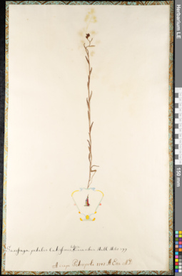
LE 01092316
Groups of specimens: Herbarium of Abraham EnsComment:
saxifraga 118
Record creation: 2020-08-28, Andrey Sytin, PhotoScan D2Citation: Specimen LE 01092316 // Virtual herbarium of Komarov Botanical Institute RAS — http://re.herbariumle.ru/01092316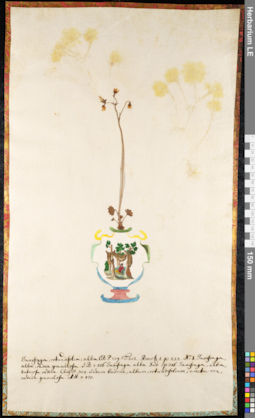
LE 01092317
Groups of specimens: Herbarium of Abraham EnsComment:
saxifraga 097
Record creation: 2020-08-28, Andrey Sytin, PhotoScan D2Citation: Specimen LE 01092317 // Virtual herbarium of Komarov Botanical Institute RAS — http://re.herbariumle.ru/01092317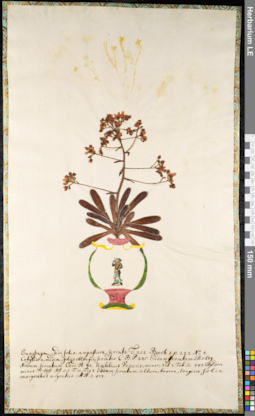
LE 01092318
Groups of specimens: Herbarium of Abraham EnsComment:
saxifraga 097
Record creation: 2020-08-28, Andrey Sytin, PhotoScan D2Citation: Specimen LE 01092318 // Virtual herbarium of Komarov Botanical Institute RAS — http://re.herbariumle.ru/01092318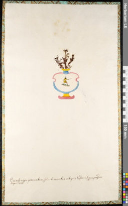
LE 01092319
Groups of specimens: Herbarium of Abraham EnsComment:
saxifraga 097
Record creation: 2020-08-28, Andrey Sytin, PhotoScan D2Citation: Specimen LE 01092319 // Virtual herbarium of Komarov Botanical Institute RAS — http://re.herbariumle.ru/01092319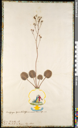
LE 01092321
Groups of specimens: Herbarium of Abraham EnsComment:
saxifraga 097
Record creation: 2020-08-28, Andrey Sytin, PhotoScan D2Citation: Specimen LE 01092321 // Virtual herbarium of Komarov Botanical Institute RAS — http://re.herbariumle.ru/01092321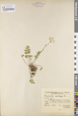
LE 01096225
Pimpinella nigra Mill. ⟨Определение на обложке рубашки⟩ det. Tzvelev, Nikolai Nikolaievich
Additional identifications: Pimpinella saxifraga L. det. Pobedimova, Evgeniia Georgievna at 23.08.1956 Administrative regions: RU - Murmanskaya Oblast'. Groups of specimens: Образцы сектора Восточной Европы; Флора Мурманской областиRecord creation: 2021-01-25, Flora of the Murmansk region, PhotoScan D2Citation: Specimen LE 01096225 // Virtual herbarium of Komarov Botanical Institute RAS — http://re.herbariumle.ru/01096225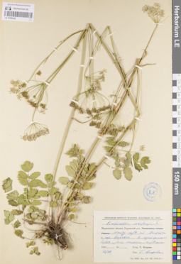
LE 01096226
Pimpinella nigra Mill. ⟨Определение на обложке рубашки⟩ det. Tzvelev, Nikolai Nikolaievich
Additional identifications: Pimpinella saxifraga L. det. Egorova, Tatiana Vladimirovna at 1957 Administrative regions: RU - Murmanskaya Oblast'. Groups of specimens: Образцы сектора Восточной Европы; Флора Мурманской областиRecord creation: 2021-01-25, Flora of the Murmansk region, PhotoScan D2Citation: Specimen LE 01096226 // Virtual herbarium of Komarov Botanical Institute RAS — http://re.herbariumle.ru/01096226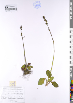
LE 01108050
Saxifraga hieracifolia Waldst. & Kit. det. Kuropatkin Vladislav at 04.08.2018
Groups of specimens: Образцы сектора Восточной ЕвропыRecord creation: 2021-04-14, Denis Melnikov, PhotoScan D2. Processing status: data is not fully enteredCitation: Specimen LE 01108050 // Virtual herbarium of Komarov Botanical Institute RAS — http://re.herbariumle.ru/01108050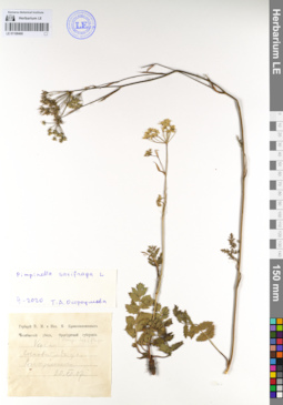
LE 01108400
Pimpinella saxifraga L. det. Ostroumova, Tatjana Aleksandrovna at 02.2020
Groups of specimens: Образцы сектора Восточной ЕвропыRecord creation: 2021-04-14, Denis Melnikov, PhotoScan D2. Processing status: data is not fully enteredCitation: Specimen LE 01108400 // Virtual herbarium of Komarov Botanical Institute RAS — http://re.herbariumle.ru/01108400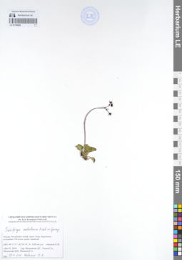
LE 01108699
Saxifraga melaleuca Fisch. ex Spreng. det. Melnikov, Denis Germanovich at 28.01.2020
Collectors: Melnikov, Denis Germanovich; Tyusov Grigorii Anatol'evich; Malysheva Darya Igorevna; Ivanova Kseniya Andreevna Expedition: Экспедиция СПбГУ и БИН на плато Укок (Республика Алтай) (07.07.2019 -07.08.2019)Groups of specimens: Образцы сектора Сибири и Дальнего Востока РоссииRecord creation: 2021-03-20, Denis Melnikov, PhotoScan D2Citation: Specimen LE 01108699 // Virtual herbarium of Komarov Botanical Institute RAS — http://re.herbariumle.ru/01108699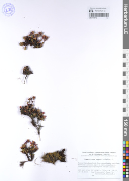
LE 01108712
Saxifraga oppositifolia L. det. Melnikov, Denis Germanovich at 01.08.2019
Collectors: Melnikov, Denis Germanovich; Tyusov Grigorii Anatol'evich; Malysheva Darya Igorevna; Ivanova Kseniya Andreevna Expedition: Экспедиция СПбГУ и БИН на плато Укок (Республика Алтай) (07.07.2019 -07.08.2019)Groups of specimens: Образцы сектора Сибири и Дальнего Востока РоссииRecord creation: 2021-03-20, Denis Melnikov, PhotoScan D2Citation: Specimen LE 01108712 // Virtual herbarium of Komarov Botanical Institute RAS — http://re.herbariumle.ru/01108712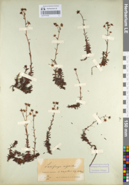
LE 01113133
Saxifraga aizoides L.
Administrative regions: FI - Finland. Groups of specimens: Образцы сектора Восточной ЕвропыRecord creation: 2021-05-23, Flora of the Murmansk region, PhotoScan D2Citation: Specimen LE 01113133 // Virtual herbarium of Komarov Botanical Institute RAS — http://re.herbariumle.ru/01113133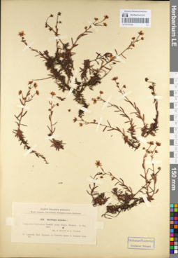
LE 01113135
Saxifraga aizoides L.
Administrative regions: FI - Finland. Groups of specimens: Образцы сектора Восточной ЕвропыRecord creation: 2021-05-23, Flora of the Murmansk region, PhotoScan D2Citation: Specimen LE 01113135 // Virtual herbarium of Komarov Botanical Institute RAS — http://re.herbariumle.ru/01113135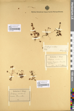
LE 01113489
Saxifraga rivularis L.
Administrative regions: RU - Murmanskaya Oblast'. Groups of specimens: Образцы сектора Восточной ЕвропыRecord creation: 2021-05-23, Flora of the Murmansk region, PhotoScan D2Citation: Specimen LE 01113489 // Virtual herbarium of Komarov Botanical Institute RAS — http://re.herbariumle.ru/01113489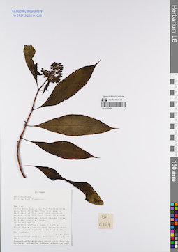
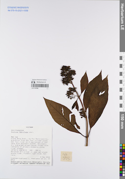
LE 01167678
Dichroa febrifuga Lour. det. Averyanov, Leonid Vladimirovich at 06.05.2000
Collectors: Averyanov, Leonid Vladimirovich; et al. Field collecting number: VH6264. Collection date: 06.05.2000. Administrative regions: VN - Tinh GJak Lak. Groups of specimens: L. V. Averyanov specimens; L. V. Averyanov herbarium; Соглашение Минобрнауки №075-15-2021-1056Original label text:FLORA OF VIETNAM
Saxifragaceae
Dichroa febrifuga Lour.
S. Vietnam, Dak Lac Prov., Krong Bong Distr., Cu Pui Municipality, elevation from Dak Tour village (12°30′N, 108°30′E) to main peak of Chu Yang Sinh mt system (12°24′N, 108°26′E) along Dak Tour river (N slope). Primary closed wet broad-leaved forest on steep granite slopes at elev. 1200-1250 m. Shrub 3-4 m hg on open mossy stream rocks. Flowers white with blue tint. Not common. VH 6264 06.05.2000
International Botanical Expedition of the U.S.A. National Geographic Society (grant No 6383-98)
Collectors: L.Averyanov, N.T.Hiep, N.Q.Hieu, P.H.Hoang, D.X.Du, N.T.Vinh
Coordinates (geographic position): 12° 30′ N, 108° 30′ E ±1000 mRecord creation: 2022-01-26, Galina Savich, PhotoScan D2. Processing status: work_status_1Citation: Specimen LE 01167678 // Virtual herbarium of Komarov Botanical Institute RAS — http://re.herbariumle.ru/01167678Saxifragaceae
Dichroa febrifuga Lour.
S. Vietnam, Dak Lac Prov., Krong Bong Distr., Cu Pui Municipality, elevation from Dak Tour village (12°30′N, 108°30′E) to main peak of Chu Yang Sinh mt system (12°24′N, 108°26′E) along Dak Tour river (N slope). Primary closed wet broad-leaved forest on steep granite slopes at elev. 1200-1250 m. Shrub 3-4 m hg on open mossy stream rocks. Flowers white with blue tint. Not common. VH 6264 06.05.2000
International Botanical Expedition of the U.S.A. National Geographic Society (grant No 6383-98)
Collectors: L.Averyanov, N.T.Hiep, N.Q.Hieu, P.H.Hoang, D.X.Du, N.T.Vinh
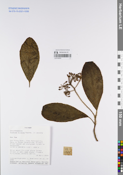
LE 01167679
Dichroa hirsuta Gagnep. det. Averyanov, Leonid Vladimirovich at 18.04.2000
Collectors: Averyanov, Leonid Vladimirovich; et al. Field collecting number: VH5388. Collection date: 18.04.2000. Administrative regions: VN - Kon Tum. Groups of specimens: L. V. Averyanov specimens; L. V. Averyanov herbarium; Соглашение Минобрнауки №075-15-2021-1056Original label text:FLORA OF VIETNAM
Saxifragaceae
Dichroa hirsuta
S. Vietnam, Kontum Prov., Kon Plong Distr., Hieu Municipality, Mang La forest enterprise (14°39′N, 108°25′E). Primary broad-leaved wet evergreen forest on sandstone at elev. 1100-1200 m. Shrub about 3 m hg
along forest stream in very deep shade. Flowers dirty-blue, anthers yellow. VH 5388 19.04.2000
International Botanical Expedition of the U.S.A. National Geographic Society (grant No 6383-98)
Collectors: L.Averyanov, P.K.Loc, P.H.Hoang, D.X.Du, N.T.Vinh
Coordinates (geographic position): 14° 39′ N, 108° 25′ E ±1000 mRecord creation: 2022-01-26, Galina Savich, PhotoScan D2. Processing status: work_status_1Citation: Specimen LE 01167679 // Virtual herbarium of Komarov Botanical Institute RAS — http://re.herbariumle.ru/01167679Saxifragaceae
Dichroa hirsuta
S. Vietnam, Kontum Prov., Kon Plong Distr., Hieu Municipality, Mang La forest enterprise (14°39′N, 108°25′E). Primary broad-leaved wet evergreen forest on sandstone at elev. 1100-1200 m. Shrub about 3 m hg
along forest stream in very deep shade. Flowers dirty-blue, anthers yellow. VH 5388 19.04.2000
International Botanical Expedition of the U.S.A. National Geographic Society (grant No 6383-98)
Collectors: L.Averyanov, P.K.Loc, P.H.Hoang, D.X.Du, N.T.Vinh
LE 01167680
Dichroa febrifuga Lour. det. Averyanov, Leonid Vladimirovich at 02.05.2000
Collectors: Averyanov, Leonid Vladimirovich; et al. Field collecting number: VH5912. Collection date: 02.05.2000. Administrative regions: VN - Tinh GJak Lak. Groups of specimens: L. V. Averyanov specimens; L. V. Averyanov herbarium; Соглашение Минобрнауки №075-15-2021-1056Original label text:FLORA OF VIETNAM
Saxifragaceae
Dichroa febrifuga Lour.
S. Vietnam, Dak Lac Prov., Krong Bong Distr., Cu Pui Municipality, elevation from Dak Tour village (12°30′N, 108°30′E) along Dak Tour river on N macroslope of Chu Yang Sinh mt system. Secondary dry evergreen broad-leaved forest with remnants of primary elements along river slopes at elev. 450-550 m. Shrublet 3-4 m hg in open wet place along river. Flowers light blue. Not rare. VH 5912 02.05.2000
International Botanical Expedition of the U.S.A. National Geographic Society (grant No 6383-98)
Collectors: L.Averyanov, N.T.Hiep, N.Q.Hieu, P.H.Hoang, D.X.Du, N.T.Vinh
Coordinates (geographic position): 12° 30′ N, 108° 30′ E ±1000 mRecord creation: 2022-01-26, Galina Savich, PhotoScan D2. Processing status: work_status_1Citation: Specimen LE 01167680 // Virtual herbarium of Komarov Botanical Institute RAS — http://re.herbariumle.ru/01167680Saxifragaceae
Dichroa febrifuga Lour.
S. Vietnam, Dak Lac Prov., Krong Bong Distr., Cu Pui Municipality, elevation from Dak Tour village (12°30′N, 108°30′E) along Dak Tour river on N macroslope of Chu Yang Sinh mt system. Secondary dry evergreen broad-leaved forest with remnants of primary elements along river slopes at elev. 450-550 m. Shrublet 3-4 m hg in open wet place along river. Flowers light blue. Not rare. VH 5912 02.05.2000
International Botanical Expedition of the U.S.A. National Geographic Society (grant No 6383-98)
Collectors: L.Averyanov, N.T.Hiep, N.Q.Hieu, P.H.Hoang, D.X.Du, N.T.Vinh
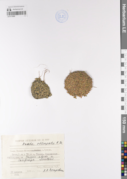
LE 01175950
Draba oblongata auct. det. Petrovsky, Vladislav Vladimirovich at 08.1979
Collectors: Safronova Irina Nikolayevna Field collecting number: 2144. Collection date: 12.08.1979. Administrative regions: RU - Arkhangel'skaya Oblast' - Primorskiy Rayon. Groups of specimens: Образцы сектора Восточной Европы; Соглашение Минобрнауки №075-15-2021-1056Original label text:Земля Франца-Иосифа, остров Гукера. Плато. 5 километров к северо-востоку от мыса Седова. Разреженные группировки из Phippsia algida и Saxifraga rivularis.
Record creation: 2023-02-09, Denis Melnikov, PhotoScan D2.Citation: Specimen LE 01175950 // Virtual herbarium of Komarov Botanical Institute RAS — http://re.herbariumle.ru/01175950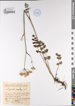
LE 01199345
Pimpinella saxifraga L. at 31.07.1929
Collectors: Avramchik, M.; Komov A.A. Collection date: 31.07.1929. Administrative regions: RU - Respublika Kareliya - Kondopozhskiy Rayon. Groups of specimens: Образцы сектора Восточной Европы; Соглашение Минобрнауки №075-15-2021-1056Original label text:Кондопожский район От тракта озера Кивач поселок Уси-кюля с 2100 метров на юго-запад в 300-400 метрах от дороги Луг, вышедший из-под соснового леса
Record creation: 2023-02-02, Denis Melnikov, PhotoScan D2.Citation: Specimen LE 01199345 // Virtual herbarium of Komarov Botanical Institute RAS — http://re.herbariumle.ru/01199345
LE 01199354
Pimpinella saxifraga L. det. Fedtschenko, Boris Alexjewitsch at 13.10.1894
Collectors: Grigorev S Collection date: 13.10.1894. Administrative regions: RU - Nizhegorodskaya Oblast' - Pil'ninskiy Rayon. Groups of specimens: Образцы сектора Восточной Европы; Соглашение Минобрнауки №075-15-2021-1056; Флора Урала и прилегающих территорий (проект)Original label text:Симбирская губерния, Курмышский уезд, село Бортсурманы, сад, открытый склон
Record creation: 2023-02-02, Denis Melnikov, PhotoScan D2.Citation: Specimen LE 01199354 // Virtual herbarium of Komarov Botanical Institute RAS — http://re.herbariumle.ru/01199354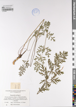
LE 01199453
Pimpinella saxifraga L. det. Konechnaya, Galina Yurievna at 09.07.1997
Collectors: Konechnaya, Galina Yurievna; Haare, Ado Oskarovich Collection date: 09.07.1997. Administrative regions: RU - Pskovskaya Oblast' - Sebezhskiy Rayon. Groups of specimens: Образцы сектора Восточной Европы; Соглашение Минобрнауки №075-15-2021-1056Original label text:Россия, Псковская область, Себежский район, от поселка Идрица 11 километров на север, от деревни Курилово 3,5 километра на восток-юго-восток, сосновый лес на правом коренном берегу реки Великая.
Record creation: 2023-02-02, Denis Melnikov, PhotoScan D2.Citation: Specimen LE 01199453 // Virtual herbarium of Komarov Botanical Institute RAS — http://re.herbariumle.ru/01199453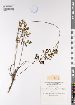
LE 01199573
Pimpinella saxifraga L. det. Konechnaya, Galina Yurievna at 14.07.2003
Collectors: Efimov, Peter Gennadievich; Konechnaya, Galina Yurievna Collection date: 14.07.2003. Administrative regions: RU - Pskovskaya Oblast' - Pustoshkinskiy Rayon. Groups of specimens: Образцы сектора Восточной Европы; Соглашение Минобрнауки №075-15-2021-1056Original label text:Россия, Псковская область, Пустошкинский район, Окрестности железнодорожного переезда между станцией Лемно и станцией Забелье, опушка сосняка.
Record creation: 2023-02-02, Denis Melnikov, PhotoScan D2.Citation: Specimen LE 01199573 // Virtual herbarium of Komarov Botanical Institute RAS — http://re.herbariumle.ru/01199573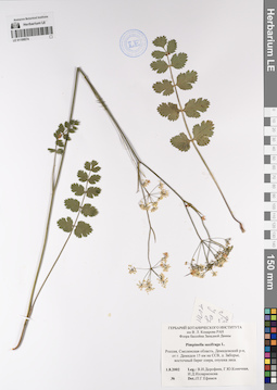
LE 01199574
Pimpinella saxifraga L. det. Efimov, Peter Gennadievich at 01.08.2002
Collectors: Dorofeev, Vladimir Ivanovich; Konechnaya, Galina Yurievna; Illarionova, Irina Dmitrievna Collection date: 01.08.2002. Administrative regions: RU - Smolenskaya Oblast'. Groups of specimens: Образцы сектора Восточной Европы; Соглашение Минобрнауки №075-15-2021-1056Original label text:Россия, Смоленская область, Демидовский район, от города Демидов 15 километров на северо-северо-восток, деревня Заборье, восточный берег озера, опушка леса.
Record creation: 2023-02-02, Denis Melnikov, PhotoScan D2.Citation: Specimen LE 01199574 // Virtual herbarium of Komarov Botanical Institute RAS — http://re.herbariumle.ru/01199574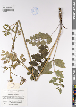
LE 01199580
Pimpinella saxifraga L. det. Konechnaya, Galina Yurievna at 05.07.2004
Collectors: Buzunova, Irina Olegovna; Efimov, Peter Gennadievich; Konechnaya, Galina Yurievna; Raenko, Larisa Mikhailovna Collection date: 05.07.2004. Administrative regions: RU - Pskovskaya Oblast' - Pustoshkinskiy Rayon. Groups of specimens: Образцы сектора Восточной Европы; Соглашение Минобрнауки №075-15-2021-1056Original label text:Россия, Псковская область, Пустошкинский район, от города Пустошка 12 километров на запад, (N: 56°19'36", E: 29°11'49") у железной дороги, опушка леса.
Coordinates (geographic position): 56° 19′ 36″ N, 29° 11′ 49″ ERecord creation: 2023-02-02, Denis Melnikov, PhotoScan D2.Citation: Specimen LE 01199580 // Virtual herbarium of Komarov Botanical Institute RAS — http://re.herbariumle.ru/01199580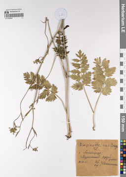
LE 01200203
Pimpinella saxifraga L. det. Unknown at 26.06.1973
Collectors: Unknown Collection date: 26.06.1973. Administrative regions: RU - Sankt-Peterburg. Groups of specimens: Образцы сектора Восточной Европы; Соглашение Минобрнауки №075-15-2021-1056Original label text:город Ленинград. Муринский ручей. у дороги.
Record creation: 2023-02-02, Denis Melnikov, PhotoScan D2.Citation: Specimen LE 01200203 // Virtual herbarium of Komarov Botanical Institute RAS — http://re.herbariumle.ru/01200203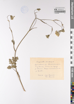
LE 01201549
Pimpinella saxifraga L. det. Byalt, Vyacheslav Vyacheslavovich at 07.07.1990
Collectors: Byalt, Vyacheslav Vyacheslavovich Collection date: 07.07.1990. Groups of specimens: Образцы сектора Восточной Европы; Соглашение Минобрнауки №075-15-2021-1056Original label text:Ярославская область, Пошехонский район, колхоз Знамя. Сосняк на берегу реки Согожи выше по течению от деревни Кривое.
Record creation: 2023-02-02, Denis Melnikov, PhotoScan D2.Citation: Specimen LE 01201549 // Virtual herbarium of Komarov Botanical Institute RAS — http://re.herbariumle.ru/01201549
LE 01226711
Saxifraga cernua L.
Collectors: Unknown Field collecting number: 333.40. Administrative regions: RU - Murmanskaya Oblast'. Groups of specimens: Образцы сектора Восточной ЕвропыOriginal label text:Littora Lapponica (Мурманский берег)
Record creation: 2023-02-07, Denis Melnikov, PhotoScan D2.Citation: Specimen LE 01226711 // Virtual herbarium of Komarov Botanical Institute RAS — http://re.herbariumle.ru/01226711
LE 01244001
Saxifraga porsildiana (Calder & Savile) Jurtzev & V.V. Petrov
Groups of specimens: Образцы сектора Сибири и Дальнего Востока России; Соглашение Минобрнауки №075-15-2021-1056Record creation: 2023-06-07, Mariya Sheludyakova, PhotoScan D2. Part1Citation: Specimen LE 01244001 // Virtual herbarium of Komarov Botanical Institute RAS — http://re.herbariumle.ru/01244001
LE 01244002
Saxifraga porsildiana (Calder & Savile) Jurtzev & V.V. Petrov
Groups of specimens: Образцы сектора Сибири и Дальнего Востока России; Соглашение Минобрнауки №075-15-2021-1056Record creation: 2023-06-07, Mariya Sheludyakova, PhotoScan D2. Part1Citation: Specimen LE 01244002 // Virtual herbarium of Komarov Botanical Institute RAS — http://re.herbariumle.ru/01244002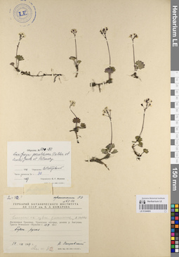
LE 01244003
Saxifraga porsildiana (Calder & Savile) Jurtzev & V.V. Petrov
Groups of specimens: Образцы сектора Сибири и Дальнего Востока России; Соглашение Минобрнауки №075-15-2021-1056Record creation: 2023-06-07, Mariya Sheludyakova, PhotoScan D2. Part1Citation: Specimen LE 01244003 // Virtual herbarium of Komarov Botanical Institute RAS — http://re.herbariumle.ru/01244003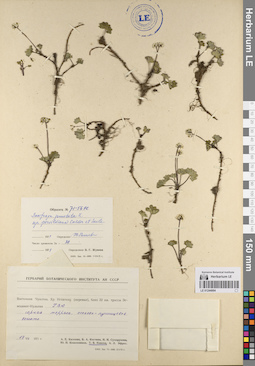
LE 01244004
Saxifraga porsildiana (Calder & Savile) Jurtzev & V.V. Petrov
Groups of specimens: Образцы сектора Сибири и Дальнего Востока России; Соглашение Минобрнауки №075-15-2021-1056Record creation: 2023-06-07, Mariya Sheludyakova, PhotoScan D2. Part1Citation: Specimen LE 01244004 // Virtual herbarium of Komarov Botanical Institute RAS — http://re.herbariumle.ru/01244004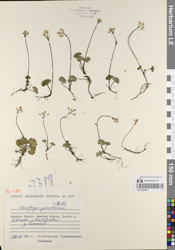
LE 01244005
Saxifraga porsildiana (Calder & Savile) Jurtzev & V.V. Petrov
Groups of specimens: Образцы сектора Сибири и Дальнего Востока России; Соглашение Минобрнауки №075-15-2021-1056Record creation: 2023-06-07, Mariya Sheludyakova, PhotoScan D2. Part1Citation: Specimen LE 01244005 // Virtual herbarium of Komarov Botanical Institute RAS — http://re.herbariumle.ru/01244005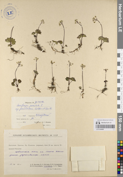
LE 01244006
Saxifraga porsildiana (Calder & Savile) Jurtzev & V.V. Petrov
Groups of specimens: Образцы сектора Сибири и Дальнего Востока России; Соглашение Минобрнауки №075-15-2021-1056Record creation: 2023-06-07, Mariya Sheludyakova, PhotoScan D2. Part1Citation: Specimen LE 01244006 // Virtual herbarium of Komarov Botanical Institute RAS — http://re.herbariumle.ru/01244006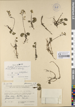
LE 01244007
Saxifraga porsildiana (Calder & Savile) Jurtzev & V.V. Petrov
Groups of specimens: Образцы сектора Сибири и Дальнего Востока России; Соглашение Минобрнауки №075-15-2021-1056Record creation: 2023-06-07, Mariya Sheludyakova, PhotoScan D2. Part1Citation: Specimen LE 01244007 // Virtual herbarium of Komarov Botanical Institute RAS — http://re.herbariumle.ru/01244007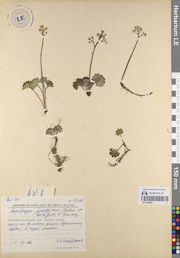
LE 01244008
Saxifraga porsildiana (Calder & Savile) Jurtzev & V.V. Petrov
Groups of specimens: Образцы сектора Сибири и Дальнего Востока России; Соглашение Минобрнауки №075-15-2021-1056Record creation: 2023-06-07, Mariya Sheludyakova, PhotoScan D2. Part1Citation: Specimen LE 01244008 // Virtual herbarium of Komarov Botanical Institute RAS — http://re.herbariumle.ru/01244008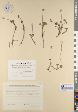
LE 01244009
Saxifraga porsildiana (Calder & Savile) Jurtzev & V.V. Petrov
Groups of specimens: Образцы сектора Сибири и Дальнего Востока России; Соглашение Минобрнауки №075-15-2021-1056Record creation: 2023-06-07, Mariya Sheludyakova, PhotoScan D2. Part1Citation: Specimen LE 01244009 // Virtual herbarium of Komarov Botanical Institute RAS — http://re.herbariumle.ru/01244009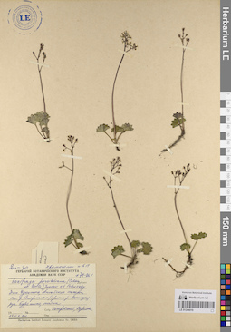
LE 01244010
Saxifraga porsildiana (Calder & Savile) Jurtzev & V.V. Petrov
Groups of specimens: Образцы сектора Сибири и Дальнего Востока России; Соглашение Минобрнауки №075-15-2021-1056Record creation: 2023-06-07, Mariya Sheludyakova, PhotoScan D2. Part1Citation: Specimen LE 01244010 // Virtual herbarium of Komarov Botanical Institute RAS — http://re.herbariumle.ru/01244010