View
Add
Copy
Edit
Delete
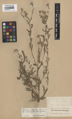
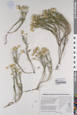
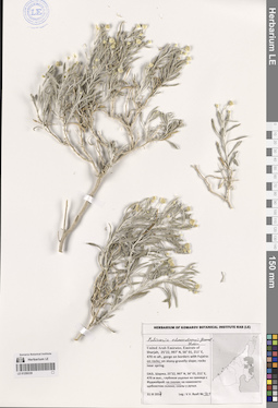
LE 00017974
Type of Pulicaria elata Boiss.
Field collecting number: 414. Collection date: 30.06.1843. Place of collection: Pl. Pers. bor. In l. humidis m. Elbrus pr. Derbend.Groups of specimens: Образцы общего сектора; Типовые образцы Общего сектораComment:[Imported description]
Family: Asteraceae
Taxon: Pulicaria elata Boiss.
Type specimen category: Type
Collectors: Th. Kotschy
Record number: 414
Collection date: 30.06.1843
Country: Russia
Locality: Pl. Pers. bor. In l. humidis m. Elbrus pr. Derbend
Family: Asteraceae
Taxon: Pulicaria elata Boiss.
Type specimen category: Type
Collectors: Th. Kotschy
Record number: 414
Collection date: 30.06.1843
Country: Russia
Locality: Pl. Pers. bor. In l. humidis m. Elbrus pr. Derbend
LE 01193679
Pulicaria edmondsonii E.Gamal-Eldin det. Byalt, Vyacheslav Vyacheslavovich
Collectors: Byalt, Vyacheslav Vyacheslavovich; Korshunov, Vladimir Mikhailovich; Melnikov, Denis Germanovich Field collecting number: 148. Collection date: 18.04.2022. Administrative regions: AE - United Arab Emirates. Place of collection: Emirate of Fujaira, NW environs of Tawaian, high mountains on border with Musandam (Oman), Olive garden on the mountain slope E exp. [point 707c]: on dry gravelly-stony slope near garden.Groups of specimens: Образцы общего сектора; Соглашение Минобрнауки №075-15-2021-1056; Бялт В.В.: Флора ФуджейрыOriginal label text: United Arab Emirates. Emirate of Fujaira, NW environs of Tawaian, high mountains on border with Musandam (Oman), Olive garden on the mountain slope E exp., 25° 38.335' N, 56° 06.951' E, 1075 m [point 707c]: on dry gravelly-stony slope near garden, 18 IV 2022, fl., fr., V.V. Byalt, V.M. Korshunov, D.G. Melnikov 148
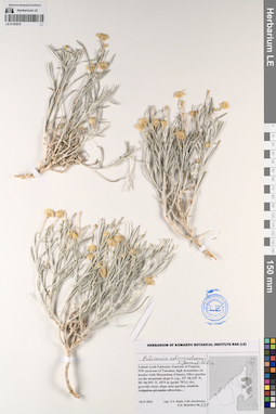
LE 01193697
Pulicaria undulata (L.) C.A.Mey. det. Byalt, Vyacheslav Vyacheslavovich
Collectors: Byalt, Vyacheslav Vyacheslavovich; Korshunov, Mikhail Vladimirovich Field collecting number: 132. Collection date: 09.03.2020. Administrative regions: AE - United Arab Emirates. Place of collection: Fujairah Emirate, mountain peak and high part of north mouth of wadi. On the border with quarries, 4.5 km east to CCR Lafarge Emirates Cement, Ras al Khaimah [point 701]: in wadi with sand and gravel.Groups of specimens: Образцы общего сектора; Соглашение Минобрнауки №075-15-2021-1056; Бялт В.В.: Флора ФуджейрыOriginal label text: United Arab Emirates, Fujairah Emirate, mountain peak and high part of north mouth of wadi. On the border with quarries, 4.5 km east to CCR Lafarge Emirates Cement, Ras al Khaimah. 25°33'33.97''N, 56°1'52.03''E, elevation 300 m. [point 701]: in wadi with sand and gravel, 9 III 2020, fl. juv., V.V. Byalt, M.V. Korshunov 132
LE 01259001
Pulicaria edmondsonii E.Gamal-Eldin det. Byalt, Vyacheslav Vyacheslavovich
Collectors: Byalt, Vyacheslav Vyacheslavovich; Korshunov, Vladimir Mikhailovich Field collecting number: 1194. Collection date: 06.04.2018. Administrative regions: AE - United Arab Emirates. Place of collection: Фуджейра, северо-западные окрестности пос. Тавайан, доломитовый хребет: щебнисто-каменистое плато.Groups of specimens: Образцы общего сектора; Соглашение Минобрнауки №075-15-2021-1056; Бялт В.В.: Флора ФуджейрыOriginal label text: United Arab Emirates. Emirate of Fujaira, NW environs of Tawaian, 25°37'21.2"N 56°05'39.7"E, 600–650 m alt., limestone (dolomite) ridge: dry gravelly-stony plateau. – ОАЭ, Фуджейра, NW окрестности пос. Тавайан, 25°37'21.2"N 56°05'39.7"E, 600–650 м н. ур. м., доломитовый хребет: щебнисто-каменистое плото, 6 IV 2018, veg., V.V. Byalt, V. Korshunov 1194/704

LE 01259004
Pulicaria edmondsonii E.Gamal-Eldin det. Byalt, Vyacheslav Vyacheslavovich
Collectors: Byalt, Vyacheslav Vyacheslavovich; Korshunov, Vladimir Mikhailovich Field collecting number: 1196/651. Collection date: 06.04.2018. Administrative regions: AE - United Arab Emirates. Place of collection: Фуджейра, 4-5 км северо-западнее пос. Габ, каменистый хребет, по дороге к вышке мобильной связи: щебнисто-каменистое плато выше дороги.Groups of specimens: Образцы общего сектора; Соглашение Минобрнауки №075-15-2021-1056; Бялт В.В.: Флора ФуджейрыOriginal label text: United Arab Emirates. Emirate of Fujaira, 4-5 km to NW of Ghub, 25°34'18.0"N 56°09'27.9"E, 700-800 m alt., stony ridge, on the way to the mobile tower: dry gravelly-stony plateau, upper of road. – ОАЭ, Фуджейра, 4-5 км на NW от пос. Габ, 25°34'18.0"N 56°09'27.9"E, 700-800 м н. ур. м., каменистый хребет, по дороге к вышке мобильной связи: щебнисто-каменистое плото выше дороги, 6 IV 2018, V.V. Byalt, V. Korshunov 1196
LE 01259005
Pulicaria glutinosa (Boiss.) Jaub. & Spach det. Byalt, Vyacheslav Vyacheslavovich
Collectors: Byalt, Vyacheslav Vyacheslavovich; Korshunov, Mikhail Vladimirovich Field collecting number: 1208/524. Collection date: 04.04.2018. Administrative regions: AE - United Arab Emirates. Place of collection: Фуджейра, пос. Аль Бидия, пустырь на окраине поселка.Groups of specimens: Образцы общего сектора; Соглашение Минобрнауки №075-15-2021-1056; Бялт В.В.: Флора ФуджейрыOriginal label text: United Arab Emirates. Emirate of Fujaira, village Al Bidiyah, 25°26'13" N, 56°20'2"° Е: wasteland near edge of village. – ОАЭ, Фуджейра, посёлок Аль Бидия, 25°26'13" N, 56°20'2"° Е: пустырь на окраине, 3–4 IV 2018 Leg.: V.V. Byalt, M.V. Korshunov 1208/524
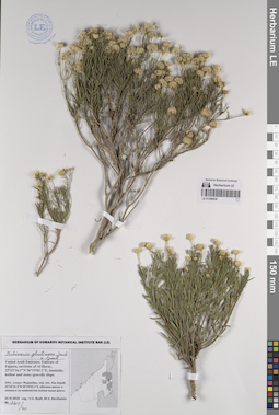
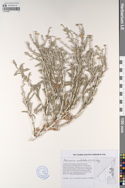
LE 01259038
Pulicaria glutinosa (Boiss.) Jaub. & Spach det. Byalt, Vyacheslav Vyacheslavovich
Collectors: Byalt, Vyacheslav Vyacheslavovich; Korshunov, Mikhail Vladimirovich Field collecting number: 1204/40. Collection date: 25.03.2018. Administrative regions: AE - United Arab Emirates. Place of collection: эмират Фуджейра, окрестности пос. Аль Харай, обочина шоссе: в низине и на каменистом склоне выше дороги.Groups of specimens: Образцы общего сектора; Соглашение Минобрнауки №075-15-2021-1056; Бялт В.В.: Флора ФуджейрыOriginal label text: United Arab Emirates. Emirate of Fujaira, environs of Al Haray, 25°23'16.3"N 56°19'02.1"E, roadside: hollow and stony-gravelly slope. – ОАЭ, эмират Фуджейра, окр. пос. Аль Харай, 25°23'16.3"N 56°19'02.1"E, обочина шоссе: в низине и на каменистом склоне выше дороги, 25 III 2018, fl., fr., V.V. Byalt, M.V. Korshunov 1204/40
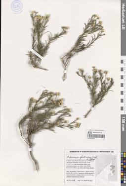
LE 01259330
Pulicaria glutinosa (Boiss.) Jaub. & Spach det. Byalt, Vyacheslav Vyacheslavovich
Collectors: Byalt, Vyacheslav Vyacheslavovich Field collecting number: 201. Collection date: 25.03.2017. Administrative regions: AE - United Arab Emirates. Place of collection: Фуджейра, Вади Вурайа Национальный парк, в 8 км северо-западнее г. Хор Факкан, выше вади: малый боковой вади.Groups of specimens: Образцы общего сектора; Соглашение Минобрнауки №075-15-2021-1056; Бялт В.В.: Флора ФуджейрыOriginal label text: United Arab Emirates. Emirate of Fujaira, Wadi Wurayah National Park, 8 km NW from Khor Fakkan, 25°23, 366’ N, 56° 18, 356’ E, upper wadi: in small lateral wadi.– ОАЭ, Фуджейра, Вади Вурайа Национальный парк, в 8 км к СЗ от г. Хор Факкан, 25°23, 366’ N, 56° 18, 356’ E, выше вади: малый боковой вади, 25 III 2017, fl., fr., V.V. Byalt 201
LE 01259331
Pulicaria glutinosa (Boiss.) Jaub. & Spach det. Byalt, Vyacheslav Vyacheslavovich
Collectors: Byalt, Vyacheslav Vyacheslavovich Field collecting number: 111. Collection date: 22.03.2017. Administrative regions: AE - United Arab Emirates. Place of collection: Фуджейра, Вади Вурайа Национальный парк, в 8 км северо-западнее г. Хор Факкан, огороженные загоны для таров в горах: низинки с песком среди каменных полей (с поливом).Groups of specimens: Образцы общего сектора; Соглашение Минобрнауки №075-15-2021-1056; Бялт В.В.: Флора ФуджейрыOriginal label text: United Arab Emirates. Emirate of Fujaira, Wadi Wurayah National Park, 8 km NW from Khor Fakkan, ca. 25°23’ N, 56° 18’ E, ca. 160–170 m alt., fenced paddocks for tar in the mountains: in the hollows with sand among the stone fields (with irrigation). – ОАЭ, Фуджейра, Вади Вурайа Национальный парк, в 8 км к СЗ от г. Хор Факкан, ca. 25°23’ N, 56° 18’ E, огороженные загоны для таров в горах: низинки с песком среди каменных полей (с поливом), 22 III 2017, fl., fr., V.V. Byalt 111
LE 01259339
Pulicaria edmondsonii E.Gamal-Eldin det. Byalt, Vyacheslav Vyacheslavovich
Collectors: Byalt, Vyacheslav Vyacheslavovich Field collecting number: 503. Collection date: 31.03.2017. Administrative regions: AE - United Arab Emirates. Place of collection: Шаржа, глубокое ущелье на границе с Фуджейрой: скалы.Groups of specimens: Образцы общего сектора; Соглашение Минобрнауки №075-15-2021-1056; Бялт В.В.: Флора ФуджейрыOriginal label text: United Arab Emirates. Emirate of Sharjah, 25°22, 997’ N, 56° 01, 211’ E, 470 m alt., gorge on borders with Fujaira: on rocks.– ОАЭ, Шаржа, 25°22, 997’ N, 56° 01, 211’ E, 470 м выс., глубокое ущелье на границе с Фуджейрой: на скалах, 31 III 2017, fl., V.V. Byalt 503
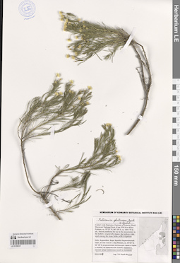
LE 01259353
Pulicaria glutinosa (Boiss.) Jaub. & Spach det. Byalt, Vyacheslav Vyacheslavovich
Collectors: Byalt, Vyacheslav Vyacheslavovich Field collecting number: 267. Collection date: 26.03.2017. Administrative regions: AE - United Arab Emirates. Place of collection: Фуджейра, окрестности г. Дадна, широкая горная долина и горные склоны: скалы и каменистые склоны.Groups of specimens: Образцы общего сектора; Соглашение Минобрнауки №075-15-2021-1056; Бялт В.В.: Флора ФуджейрыOriginal label text: United Arab Emirates. Emirate of Fujaira, environs of Dadna, 25°24, 018’ N, 56° 17,475’ E: wide mountain valley and mountain slopes: on rocks and stony slopes. – ОАЭ, Фуджейра, окрестности г. Дадна, 25°24, 018’ N, 56° 17,475’ E: широкая горная долина и горные склоны: на скалах и каменистых склонах. 26-27 III 2017, fl., fr., V.V. Byalt 267
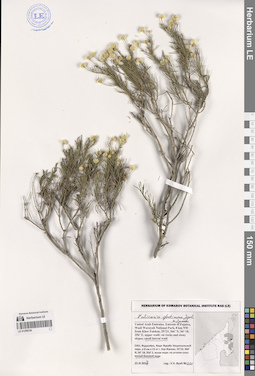
LE 01259357
Pulicaria glutinosa (Boiss.) Jaub. & Spach det. Byalt, Vyacheslav Vyacheslavovich
Collectors: Byalt, Vyacheslav Vyacheslavovich Field collecting number: 468. Collection date: 30.03.2017. Administrative regions: AE - United Arab Emirates. Place of collection: Фуджейра, окрестности г. Манама: на скалах-останцах (среди песков).Groups of specimens: Образцы общего сектора; Соглашение Минобрнауки №075-15-2021-1056; Бялт В.В.: Флора ФуджейрыOriginal label text: United Arab Emirates. Emirate of Fujaira, environs of Al Manama, 25°20,020’ N, 56° 11,847’ E: on destroyed rocky outcrops. – ОАЭ, Фуджейра, окрестности г. Манама, 25°20,020’ N, 56° 11,847’ E: на скалах останцах (среди песков), 30 III 2017, fl., V.V. Byalt 468
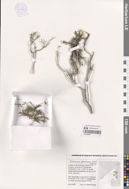
LE 01259372
Pulicaria glutinosa (Boiss.) Jaub. & Spach det. Byalt, Vyacheslav Vyacheslavovich
Collectors: Byalt, Vyacheslav Vyacheslavovich; Korshunov, Mikhail Vladimirovich Field collecting number: 267. Collection date: 11.03.2020. Administrative regions: AE - United Arab Emirates. Place of collection: Fujairah Emirate, Al Hayl Fort (Al Hayl Castle) [point 704]: near the Fort, on mountain side, lower part.Groups of specimens: Образцы общего сектора; Соглашение Минобрнауки №075-15-2021-1056; Бялт В.В.: Флора ФуджейрыOriginal label text: UAE, Fujairah Emirate, Al Hayl Fort (Al Hayl Castle). 25° 5'4.59"N, 56°13'36.84"E, elevation 240–310 m [point 704]: near the Fort, on mountain side, lower part, 11 III 2020, fl., fr., V.V. Byalt, M.V. Korshunov 267
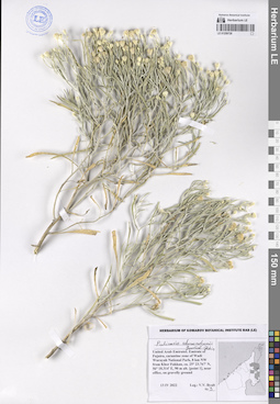
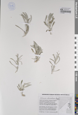
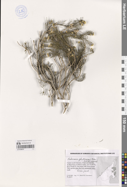
LE 01259728
Pulicaria edmondsonii E.Gamal-Eldin det. Byalt, Vyacheslav Vyacheslavovich
Collectors: Byalt, Vyacheslav Vyacheslavovich Field collecting number: 3. Collection date: 13.04.2022. Administrative regions: AE - United Arab Emirates. Place of collection: Emirate of Fujaira, carantine zone of Wadi Wurayah National Park, 8 km NW from Khor Fakkan, near office, on gravelly ground.Groups of specimens: Образцы общего сектора; Соглашение Минобрнауки №075-15-2021-1056; Бялт В.В.: Флора ФуджейрыOriginal label text: United Arab Emirates. Emirate of Fujaira, carantine zone of Wadi Wurayah National Park, 8 km NW from Khor Fakkan, ca. 25° 23.767' N, 56° 18.314' E, 90 m alt., near office, on gravelly ground, 13 IV 2022, fl., V.V. Byalt 3