View
Add
Copy
Edit
Delete
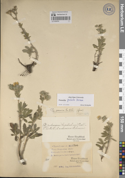
LE 01262516
Potentilla pedata Willd. ex Hornem. det. Kechaykin, Alexey Anatol'yevich at 04.11.2016
Additional identifications: Potentilla hirta var. subsericea Griseb. det. Siegfried, Hans; Potentilla adscharica Sommier & Levier det. Wolf, Frans Theodor Collectors: Alexeenko, Fyodor Nikitich Field collecting number: 5714. Collection date: 30.05.1901. Administrative regions: RU - Dagestan. Groups of specimens: Образцы сектора Кавказа; Соглашение Минобрнауки №075-15-2021-1056Original label text:Flora Caucasi
Coordinates (geographic position): 42° 27′ 14.76″ N, 47° 39′ 46.08″ EComment: Prov. Dagestan, distr. Kaitagh-Tabassaran, pr. Deschlagar in decliv. herbosis, 1500', [№] 5714, 30 Maj. 1901, Alexeenko
Deschlagar = Sergokala
Record creation: 2023-11-02, Иван Владимирович ТатановCitation: Specimen LE 01262516 // Virtual herbarium of Komarov Botanical Institute RAS — http://re.herbariumle.ru/01262516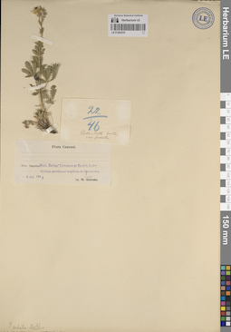
LE 01262519
Potentilla pedata Willd. ex Hornem. det. Kechaykin, Alexey Anatol'yevich
Additional identifications: Potentilla hirta var. pedata (Willd. ex Hornem.) W.D.J.Koch Collectors: Alexeenko, Fyodor Nikitich Collection date: 09.07.1898. Administrative regions: RU - Dagestan. Groups of specimens: Образцы сектора Кавказа; Соглашение Минобрнауки №075-15-2021-1056Original label text:Flora Caucasi
Record creation: 2023-11-02, Иван Владимирович ТатановCitation: Specimen LE 01262519 // Virtual herbarium of Komarov Botanical Institute RAS — http://re.herbariumle.ru/01262519Prov. Dagestan, Distr. Kaitag-Tabasaran, pr. Baschli, in declivitat. meridional argilloso m. Ljavan-dag, 1500', 9 Jul. 1898, Th. Alexeenko
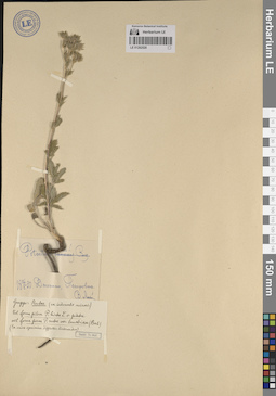
LE 01262520
Potentilla pedata Willd. ex Hornem. det. Kechaykin, Alexey Anatol'yevich
Additional identifications: Potentilla recta L. det. Lipsky, Vladimir Ippolitovich; Potentilla hirta var. pedata (Willd. ex Hornem.) W.D.J.Koch det. Wolf, Frans Theodor; Potentilla recta var. leucotricha (Borbás) Vollm. det. Wolf, Frans Theodor Collectors: Lipsky, Vladimir Ippolitovich Collection date: 26.05.1890. Administrative regions: RU - Dagestan. Groups of specimens: Образцы сектора Кавказа; Соглашение Минобрнауки №075-15-2021-1056Original label text:Дагестан, Петровск, 26 V 1890, В. Липский
Coordinates (geographic position): 42° 58′ 59.88″ N, 47° 30′ 0.36″ EComment: Петровск = Махачкала
Record creation: 2023-11-02, Иван Владимирович ТатановCitation: Specimen LE 01262520 // Virtual herbarium of Komarov Botanical Institute RAS — http://re.herbariumle.ru/01262520
LE 01262614
Potentilla adscharica Sommier & Levier det. Kechaykin, Alexey Anatol'yevich at 15.11.2023
Additional identifications: Potentilla hirta L. Collectors: Ruprecht, Franz Josef Collection date: 05.06.1861. Administrative regions: RU - Dagestan. Groups of specimens: Образцы сектора Кавказа; Соглашение Минобрнауки №075-15-2021-1056Original label text:In campis in promontorio Cauc. bor. orient., pr. Petrowsk, 5 Jun. 1861, R[uprecht]
Petrowsk = Махачкала
Record creation: 2023-11-14, Иван Владимирович ТатановCitation: Specimen LE 01262614 // Virtual herbarium of Komarov Botanical Institute RAS — http://re.herbariumle.ru/01262614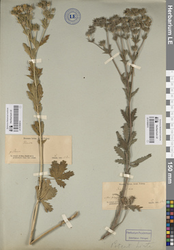
LE 01262615
Potentilla adscharica Sommier & Levier det. Ruprecht, Franz Josef at 15.11.2023
Additional identifications: Potentilla hirta L. Collectors: Ruprecht, Franz Josef Collection date: 01.06.1861. Administrative regions: RU - Stavropol'skiy Kray. Groups of specimens: Образцы сектора Кавказа; Соглашение Минобрнауки №075-15-2021-1056Original label text:In campis ad fluv. Terek, ad stat. Galigajewskaja pr. Mosdok, 1 Juni 1861, R[uprecht]
Coordinates (geographic position): 43° 41′ 41.12″ N, 44° 56′ 16.3″ EComment: Galigajewskaja = станица Галюгаевская в Курском муниципальном округе Ставропольского края России.
Record creation: 2023-11-14, Иван Владимирович ТатановCitation: Specimen LE 01262615 // Virtual herbarium of Komarov Botanical Institute RAS — http://re.herbariumle.ru/01262615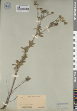
LE 01262617
Potentilla adscharica Sommier & Levier det. Kechaykin, Alexey Anatol'yevich at 15.11.2023
Additional identifications: Potentilla hirta L. Collectors: Ruprecht, Franz Josef Collection date: 09.08.1860. Administrative regions: RU - Dagestan. Groups of specimens: Образцы сектора Кавказа; Соглашение Минобрнауки №075-15-2021-1056Original label text:Caucasus orient., Dagestania superior montosa, Kaputscha, in reg. sylv. ad fl. Simur [Samur] 860-870 hex, 9 Aug. 1860, Ruprecht
Coordinates (geographic position): 42° 8′ 47.67″ N, 45° 56′ 21.06″ EComment: Kaputscha = Капуджа / Капутжа - район рядом с селом Бежта Бежтинского муниципального участка Цунтинского района Дагестана (данные Р.А. Муртазилиева)
Record creation: 2023-11-14, Иван Владимирович ТатановCitation: Specimen LE 01262617 // Virtual herbarium of Komarov Botanical Institute RAS — http://re.herbariumle.ru/01262617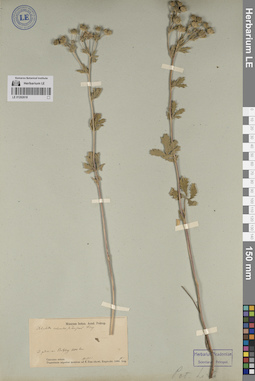
LE 01262618
Potentilla adscharica Sommier & Levier det. Kechaykin, Alexey Anatol'yevich at 15.11.2023
Additional identifications: Potentilla intermedia var. canescens det. Ruprecht, Franz Josef; Potentilla hirta L. Collectors: Ruprecht, Franz Josef Collection date: 15.08.1860. Administrative regions: RU - Dagestan. Groups of specimens: Образцы сектора Кавказа; Соглашение Минобрнауки №075-15-2021-1056Original label text:Caucasus orient., Dagestania superior montosa ad fontes fl. Ilan-chewi, ad pedem m. Botschog 1200 hex., 15 Aug. 1860, Ruprecht.
Comment: Ilan-chewi = река Шаитли
Record creation: 2023-11-14, Иван Владимирович ТатановCitation: Specimen LE 01262618 // Virtual herbarium of Komarov Botanical Institute RAS — http://re.herbariumle.ru/01262618