View
Add
Copy
Edit
Delete
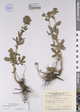
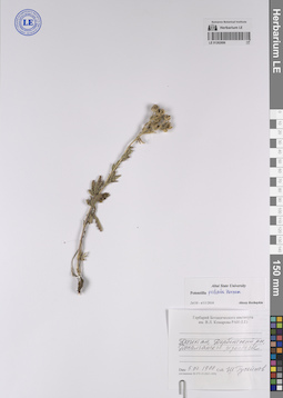
LE 01262512
Potentilla adscharica Sommier & Levier det. Kechaykin, Alexey Anatol'yevich at 15.11.2023
Additional identifications: Potentilla recta L. det. Husseinov, Sch. A.; Potentilla pedata Willd. ex Hornem. det. Kechaykin, Alexey Anatol'yevich at 04.11.2016 Collectors: Husseinov, Sch. A. Collection date: 29.05.1974. Administrative regions: RU - Dagestan. Groups of specimens: Образцы сектора Кавказа; Соглашение Минобрнауки №075-15-2021-1056Original label text:Дагестан, окр. г. Махачкала, гора Тарки-Тау, в лесу, 29 V 1974, Ш. А. Гусейнов
Coordinates (geographic position): 42° 56′ 27.24″ N, 47° 27′ 12.6″ ERecord creation: 2023-11-02, Иван Владимирович ТатановCitation: Specimen LE 01262512 // Virtual herbarium of Komarov Botanical Institute RAS — http://re.herbariumle.ru/01262512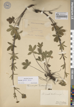
LE 01262515
Potentilla adscharica Sommier & Levier det. Wolf, Frans Theodor, Kechaykin, Alexey Anatol'yevich
Additional identifications: Potentilla pedata Willd. ex Hornem. det. Siegfried, Hans, Kechaykin, Alexey Anatol'yevich Collectors: Alexeenko, Fyodor Nikitich Field collecting number: 5740. Collection date: 11.05.1901. Administrative regions: RU - North Ossetia. Groups of specimens: Образцы сектора Кавказа; Соглашение Минобрнауки №075-15-2021-1056Original label text:Flora Caucasi
Coordinates (geographic position): 43° 11′ 19.32″ N, 44° 31′ 18.48″ ERecord creation: 2023-11-02, Иван Владимирович ТатановCitation: Specimen LE 01262515 // Virtual herbarium of Komarov Botanical Institute RAS — http://re.herbariumle.ru/01262515[№] 5740
Prov. Terek, prope st. viae ferr. Beslan, in neglectis, 1500', 11 Maj. 1901, Alexeenko
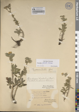
LE 01262516
Potentilla pedata Willd. ex Hornem. det. Kechaykin, Alexey Anatol'yevich at 04.11.2016
Additional identifications: Potentilla hirta var. subsericea Griseb. det. Siegfried, Hans; Potentilla adscharica Sommier & Levier det. Wolf, Frans Theodor Collectors: Alexeenko, Fyodor Nikitich Field collecting number: 5714. Collection date: 30.05.1901. Administrative regions: RU - Dagestan. Groups of specimens: Образцы сектора Кавказа; Соглашение Минобрнауки №075-15-2021-1056Original label text:Flora Caucasi
Coordinates (geographic position): 42° 27′ 14.76″ N, 47° 39′ 46.08″ EComment: Prov. Dagestan, distr. Kaitagh-Tabassaran, pr. Deschlagar in decliv. herbosis, 1500', [№] 5714, 30 Maj. 1901, Alexeenko
Deschlagar = Sergokala
Record creation: 2023-11-02, Иван Владимирович ТатановCitation: Specimen LE 01262516 // Virtual herbarium of Komarov Botanical Institute RAS — http://re.herbariumle.ru/01262516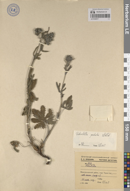
LE 01262517
Potentilla adscharica Sommier & Levier det. Kechaykin, Alexey Anatol'yevich at 15.11.2023
Additional identifications: Potentilla pedata Willd. ex Hornem. det. Husseinov, Sch. A. at 1987 Collectors: Prokhanov, Yaroslav Ivanovich Field collecting number: 272. Collection date: 10.05.1953. Administrative regions: RU - Dagestan. Groups of specimens: Образцы сектора Кавказа; Соглашение Минобрнауки №075-15-2021-1056Original label text:№ 272
Coordinates (geographic position): 42° 56′ 27.24″ N, 47° 27′ 12.6″ ERecord creation: 2023-11-02, Иван Владимирович ТатановCitation: Specimen LE 01262517 // Virtual herbarium of Komarov Botanical Institute RAS — http://re.herbariumle.ru/01262517Махачкалинский район, гора Тарки-тау, сев. склон (сред. ч.), 10 мая 1953 г., Я. И. Проханов
LE 01262606
Potentilla adscharica Sommier & Levier det. Kechaykin, Alexey Anatol'yevich at 15.11.2023
Additional identifications: Potentilla pedata Willd. ex Hornem. det. Kechaykin, Alexey Anatol'yevich at 24.10.2016 Collectors: Husseinov, Sch. A. Collection date: 05.07.1988. Administrative regions: RU - Dagestan. Groups of specimens: Типовые образцы сектора Кавказа; Соглашение Минобрнауки №075-15-2021-1056Original label text:[Дагестан] Дербентский р-н, Джалганское редколесье, 5 VII 1988, Ш. Гусейнов
Record creation: 2023-11-14, Иван Владимирович ТатановCitation: Specimen LE 01262606 // Virtual herbarium of Komarov Botanical Institute RAS — http://re.herbariumle.ru/01262606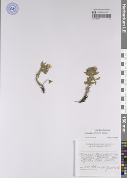
LE 01262607
Potentilla adscharica Sommier & Levier det. Kechaykin, Alexey Anatol'yevich at 15.11.2023
Additional identifications: Potentilla pedata Willd. ex Hornem. det. Kechaykin, Alexey Anatol'yevich at 24.10.2016 Collectors: Husseinov, Sch. A. Collection date: 09.07.1988. Administrative regions: RU - Dagestan. Groups of specimens: Типовые образцы сектора Кавказа; Соглашение Минобрнауки №075-15-2021-1056Original label text:[Дагестан] Ботлихский р-н, турб[аза] Ботлих, на лугах (альп. пояс), 9 VII 1988, Ш.А. Гусейнов
Coordinates (geographic position): 42° 40′ 4.92″ N, 46° 12′ 41.62″ ERecord creation: 2023-11-14, Иван Владимирович ТатановCitation: Specimen LE 01262607 // Virtual herbarium of Komarov Botanical Institute RAS — http://re.herbariumle.ru/01262607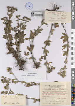
LE 01262608
Potentilla adscharica Sommier & Levier det. Husseinov, Sch. A. at 1987
Additional identifications: Potentilla recta L. det. Husseinov, Sch. A. at 1987; Potentilla pedata Willd. ex Hornem. det. Kechaykin, Alexey Anatol'yevich at 24.10.2016 Collectors: Husseinov, Sch. A. Collection date: 01.06.1975. Administrative regions: RU - Dagestan. Groups of specimens: Образцы сектора Кавказа; Соглашение Минобрнауки №075-15-2021-1056Original label text:Дагестан, окр. г. Махачкала, гора Тарки-Тау, на лесных полянах, 1 VI 1975, Ш.А. Гусейнов
Coordinates (geographic position): 42° 56′ 23.79″ N, 47° 27′ 19.22″ ERecord creation: 2023-11-14, Иван Владимирович ТатановCitation: Specimen LE 01262608 // Virtual herbarium of Komarov Botanical Institute RAS — http://re.herbariumle.ru/01262608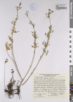
LE 01262609
Potentilla adscharica Sommier & Levier det. Kechaykin, Alexey Anatol'yevich at 15.11.2023
Additional identifications: Potentilla pedata Willd. ex Hornem. det. Kechaykin, Alexey Anatol'yevich Collectors: Tzvelev, Nikolai Nikolaievich; Czerepanov, Sergei Kirillovich; Nepli, Georgy Nikolaevich; Bobrov, Andrej Evgenievich Field collecting number: 441. Collection date: 07.06.1961. Administrative regions: RU - Dagestan. Groups of specimens: Образцы сектора Кавказа; Соглашение Минобрнауки №075-15-2021-1056Original label text:Дагестанская АССР, район Буйнакский, восточная часть Гимринского хребта к западу от сел. Верхние Казанища, щебнистый луг на вершине отрога хребта, 7 июня 1961, № 441, Н.Н. Цвелёв, С.К. Черепанов, Г.Н. Непли, А.Е. Бобров
Coordinates (geographic position): 42° 44′ 8.7″ N, 47° 8′ 17.35″ ERecord creation: 2023-11-14, Иван Владимирович ТатановCitation: Specimen LE 01262609 // Virtual herbarium of Komarov Botanical Institute RAS — http://re.herbariumle.ru/01262609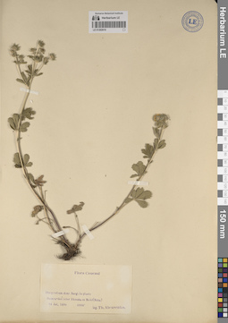
LE 01262610
Potentilla adscharica Sommier & Levier det. Kechaykin, Alexey Anatol'yevich at 15.11.2023
Collectors: Alexeenko, Fyodor Nikitich Collection date: 14.07.1898. Administrative regions: RU - Dagestan. Groups of specimens: Образцы сектора Кавказа; Соглашение Минобрнауки №075-15-2021-1056Original label text:Dagestan, distr. Dargi, in pineto Gumra-duz inter Akuscha et Muhi (Meha), 14 Jul. 1898, 4800', Th. Alexeenko
Coordinates (geographic position): 42° 17′ 18.36″ N, 47° 22′ 53.22″ ERecord creation: 2023-11-14, Иван Владимирович ТатановCitation: Specimen LE 01262610 // Virtual herbarium of Komarov Botanical Institute RAS — http://re.herbariumle.ru/01262610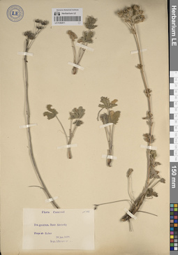
LE 01262611
Potentilla adscharica Sommier & Levier det. Kechaykin, Alexey Anatol'yevich at 15.11.2023
Collectors: Alexeenko, Fyodor Nikitich Field collecting number: 146. Collection date: 29.06.1899. Administrative regions: RU - Dagestan. Groups of specimens: Образцы сектора КавказаOriginal label text:Dagestan, distr. Kurinsky, prope st. Rubas, 20 Jun. 1899, Alexeenko
Coordinates (geographic position): 41° 53′ 34.12″ N, 48° 19′ 37.46″ ERecord creation: 2023-11-14, Иван Владимирович ТатановCitation: Specimen LE 01262611 // Virtual herbarium of Komarov Botanical Institute RAS — http://re.herbariumle.ru/01262611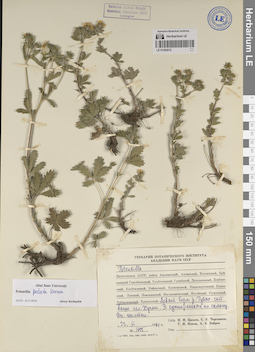
LE 01262612
Potentilla adscharica Sommier & Levier det. Kechaykin, Alexey Anatol'yevich at 15.11.2023
Additional identifications: Potentilla pedata Willd. ex Hornem. det. Kechaykin, Alexey Anatol'yevich at 24.10.2016 Collectors: Tzvelev, Nikolai Nikolaievich; Czerepanov, Sergei Kirillovich; Nepli, Georgy Nikolaevich; Bobrov, Andrej Evgenievich Field collecting number: 1705. Collection date: 23.06.1961. Administrative regions: RU - Dagestan. Groups of specimens: Образцы сектора Кавказа; Соглашение Минобрнауки №075-15-2021-1056Original label text:Дагестанская АССР, район Табасаранский, левый берег реки Рубас-чай, выше сел. Хучни, в кустарниках по склону. Вн. желтые. 23 VI 1961, Н.Н. Цвелёв, С.К. Черепанов, Г.Н. Непли, А.Е. Бобров
Coordinates (geographic position): 41° 56′ 10.36″ N, 47° 56′ 4.84″ ERecord creation: 2023-11-14, Иван Владимирович ТатановCitation: Specimen LE 01262612 // Virtual herbarium of Komarov Botanical Institute RAS — http://re.herbariumle.ru/01262612
LE 01262614
Potentilla adscharica Sommier & Levier det. Kechaykin, Alexey Anatol'yevich at 15.11.2023
Additional identifications: Potentilla hirta L. Collectors: Ruprecht, Franz Josef Collection date: 05.06.1861. Administrative regions: RU - Dagestan. Groups of specimens: Образцы сектора Кавказа; Соглашение Минобрнауки №075-15-2021-1056Original label text:In campis in promontorio Cauc. bor. orient., pr. Petrowsk, 5 Jun. 1861, R[uprecht]
Petrowsk = Махачкала
Record creation: 2023-11-14, Иван Владимирович ТатановCitation: Specimen LE 01262614 // Virtual herbarium of Komarov Botanical Institute RAS — http://re.herbariumle.ru/01262614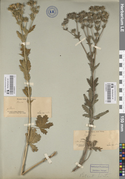
LE 01262615
Potentilla adscharica Sommier & Levier det. Ruprecht, Franz Josef at 15.11.2023
Additional identifications: Potentilla hirta L. Collectors: Ruprecht, Franz Josef Collection date: 01.06.1861. Administrative regions: RU - Stavropol'skiy Kray. Groups of specimens: Образцы сектора Кавказа; Соглашение Минобрнауки №075-15-2021-1056Original label text:In campis ad fluv. Terek, ad stat. Galigajewskaja pr. Mosdok, 1 Juni 1861, R[uprecht]
Coordinates (geographic position): 43° 41′ 41.12″ N, 44° 56′ 16.3″ EComment: Galigajewskaja = станица Галюгаевская в Курском муниципальном округе Ставропольского края России.
Record creation: 2023-11-14, Иван Владимирович ТатановCitation: Specimen LE 01262615 // Virtual herbarium of Komarov Botanical Institute RAS — http://re.herbariumle.ru/01262615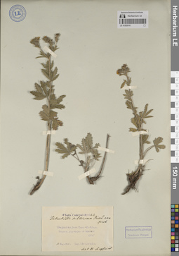
LE 01262616
Potentilla adscharica Sommier & Levier det. Kechaykin, Alexey Anatol'yevich at 15.11.2023
Additional identifications: Potentilla subsericea (Griseb.) Hausskn. det. Siegfried, Hans Collectors: Alexeenko, Fyodor Nikitich Field collecting number: 10762. Collection date: 12.05.1901. Administrative regions: RU - Dagestan. Groups of specimens: Образцы сектора Кавказа; Соглашение Минобрнауки №075-15-2021-1056Original label text:Dagestan, distr. Temir-Ch. Schura, prope st. Atly-bujun, in lapidosis, 1200', 12 Maj. 1901, Alexeenko
Coordinates (geographic position): 42° 33′ 36.8″ N, 47° 42′ 58.02″ ERecord creation: 2023-11-14, Иван Владимирович ТатановCitation: Specimen LE 01262616 // Virtual herbarium of Komarov Botanical Institute RAS — http://re.herbariumle.ru/01262616
LE 01262617
Potentilla adscharica Sommier & Levier det. Kechaykin, Alexey Anatol'yevich at 15.11.2023
Additional identifications: Potentilla hirta L. Collectors: Ruprecht, Franz Josef Collection date: 09.08.1860. Administrative regions: RU - Dagestan. Groups of specimens: Образцы сектора Кавказа; Соглашение Минобрнауки №075-15-2021-1056Original label text:Caucasus orient., Dagestania superior montosa, Kaputscha, in reg. sylv. ad fl. Simur [Samur] 860-870 hex, 9 Aug. 1860, Ruprecht
Coordinates (geographic position): 42° 8′ 47.67″ N, 45° 56′ 21.06″ EComment: Kaputscha = Капуджа / Капутжа - район рядом с селом Бежта Бежтинского муниципального участка Цунтинского района Дагестана (данные Р.А. Муртазилиева)
Record creation: 2023-11-14, Иван Владимирович ТатановCitation: Specimen LE 01262617 // Virtual herbarium of Komarov Botanical Institute RAS — http://re.herbariumle.ru/01262617
LE 01262618
Potentilla adscharica Sommier & Levier det. Kechaykin, Alexey Anatol'yevich at 15.11.2023
Additional identifications: Potentilla intermedia var. canescens det. Ruprecht, Franz Josef; Potentilla hirta L. Collectors: Ruprecht, Franz Josef Collection date: 15.08.1860. Administrative regions: RU - Dagestan. Groups of specimens: Образцы сектора Кавказа; Соглашение Минобрнауки №075-15-2021-1056Original label text:Caucasus orient., Dagestania superior montosa ad fontes fl. Ilan-chewi, ad pedem m. Botschog 1200 hex., 15 Aug. 1860, Ruprecht.
Comment: Ilan-chewi = река Шаитли
Record creation: 2023-11-14, Иван Владимирович ТатановCitation: Specimen LE 01262618 // Virtual herbarium of Komarov Botanical Institute RAS — http://re.herbariumle.ru/01262618