View
Add
Copy
Edit
Delete
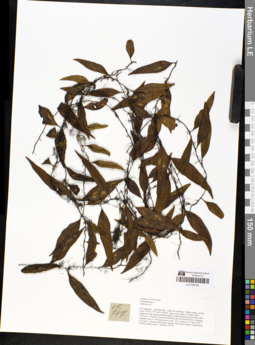
LE 01050100
Lemmaphyllum rostratum (Beddome) Tag. det. X.C.Zhang at 05.07.2019
Additional identifications: Lepisorus sp. ⟮prelim. ID⟯ det. Averyanov, Leonid Vladimirovich at 23.04.2018 Collectors: Averyanov, Leonid Vladimirovich; Khang Sinh Nguyen; Tien Hiep Nguyen; Nguyen Quang Hieu; Chuong Quang Ngan; Maisak, Tatiana Viktorovna Field collecting number: VR747. Collection date: 23.04.2018. Administrative regions: VN - Tinh Ha Giang. Groups of specimens: L. V. Averyanov specimens; L. V. Averyanov herbarium; L. V. Averyanov photosOriginal label text:FLORA OF VIETNAM Polypodiaceae s.l. Lepisorus sp.? Ha Giang prov., Quan Ba distr., Tung Vai commune, Thang village, around point 23º03ʹ13.4ʺN 104º51ʹ48.8ʺE, steep rocky slopes of stream valley composed with eroded stratified highly eroded limestone at elevation 1000-1200 m a.s.l. Primary evergreen broad-leaved very humid forest. Creeping empathic vine to 1 m long on mossy tree. Very common. 23 April 2018, L. Averyanov, Nguyen Sinh Khang, Nguyen Tien Hiep, Nguyen Quang Hieu, Chuong Quang Ngan, T. Maisak, VR 747.
Coordinates (geographic position): 23° 3′ 13.4″ N, 104° 51′ 48.8″ E ±1000 mComment: All photos © L. Averyanov & K.S. Nguyen
Record creation: 2019-04-21, Leonid Averyanov, PhotoScan D1Citation: Specimen LE 01050100 // Virtual herbarium of Komarov Botanical Institute RAS — http://re.herbariumle.ru/01050100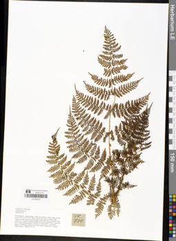
LE 01050101
Peranema aspidioides (Blume) Mett. det. Averyanov, Leonid Vladimirovich at 07.09.2019
Additional identifications: Rumohra sp. ⟮prelim. ID⟯ det. Averyanov, Leonid Vladimirovich at 23.04.2018; Diacalpe sp. det. X.C.Zhang at 05.07.2019 Collectors: Averyanov, Leonid Vladimirovich; Khang Sinh Nguyen; Tien Hiep Nguyen; Nguyen Quang Hieu; Chuong Quang Ngan; Maisak, Tatiana Viktorovna Field collecting number: VR730. Collection date: 23.04.2018. Administrative regions: VN - Tinh Ha Giang. Groups of specimens: L. V. Averyanov specimens; L. V. Averyanov herbarium; L. V. Averyanov photosOriginal label text:FLORA OF VIETNAM Polypodiaceae s.l. Ruhmora sp.? Ha Giang prov., Quan Ba distr., Tung Vai commune, Thang village, around point 23º03ʹ13.4ʺN 104º51ʹ48.8ʺE, steep rocky slopes of stream valley composed with eroded stratified highly eroded limestone at elevation 1000-1200 m a.s.l. Primary evergreen broad-leaved very humid forest. Terrestrial fern in shady flattened place. Common. 23 April 2018, L. Averyanov, Nguyen Sinh Khang, Nguyen Tien Hiep, Nguyen Quang Hieu, Chuong Quang Ngan, T. Maisak, VR 730.
Coordinates (geographic position): 23° 3′ 13.4″ N, 104° 51′ 48.8″ E ±1000 mComment: All photos © L. Averyanov & K.S. Nguyen
Record creation: 2019-04-21, Leonid Averyanov, PhotoScan D1Citation: Specimen LE 01050101 // Virtual herbarium of Komarov Botanical Institute RAS — http://re.herbariumle.ru/01050101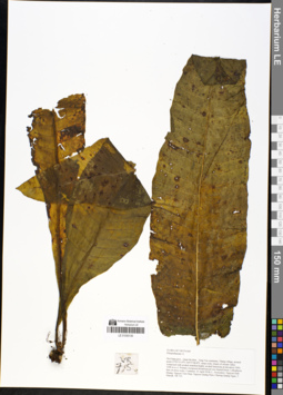
LE 01050130
Microsorum carinatum (W.M.Chu & Z.R.He) S.G.Lu det. X.C.Zhang at 05.07.2019
Additional identifications: Polypodiaceae sp. ⟮s. l.⟯ det. Averyanov, Leonid Vladimirovich at 23.04.2018 Collectors: Averyanov, Leonid Vladimirovich; Khang Sinh Nguyen; Tien Hiep Nguyen; Nguyen Quang Hieu; Chuong Quang Ngan; Maisak, Tatiana Viktorovna Field collecting number: VR715. Collection date: 23.04.2018. Administrative regions: VN - Tinh Ha Giang. Groups of specimens: L. V. Averyanov specimens; L. V. Averyanov herbarium; L. V. Averyanov photosOriginal label text:FLORA OF VIETNAM Polypodiaceae s.l. Ha Giang prov., Quan Ba distr., Tung Vai commune, Thang village, around point 23º03ʹ13.4ʺN 104º51ʹ48.8ʺE, steep rocky slopes of stream valley composed with eroded stratified highly eroded limestone at elevation 1000-1200 m a.s.l. Primary evergreen broad-leaved very humid forest. Lithophytic fern on moss rocks. Common. 23 April 2018, L. Averyanov, Nguyen Sinh Khang, Nguyen Tien Hiep, Nguyen Quang Hieu, Chuong Quang Ngan, T. Maisak, VR 715.
Coordinates (geographic position): 23° 3′ 13.4″ N, 104° 51′ 48.8″ E ±1000 mComment: All photos © L. Averyanov & K.S. Nguyen
Record creation: 2019-04-21, Leonid Averyanov, PhotoScan D1Citation: Specimen LE 01050130 // Virtual herbarium of Komarov Botanical Institute RAS — http://re.herbariumle.ru/01050130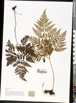
LE 01050131
Davallia solida (G. Forst.) Sw. det. X.C.Zhang at 05.07.2019
Additional identifications: Davallia sp. det. Averyanov, Leonid Vladimirovich at 23.04.2018 Collectors: Averyanov, Leonid Vladimirovich; Khang Sinh Nguyen; Tien Hiep Nguyen; Nguyen Quang Hieu; Chuong Quang Ngan; Maisak, Tatiana Viktorovna Field collecting number: VR722. Collection date: 23.04.2018. Administrative regions: VN - Tinh Ha Giang. Groups of specimens: L. V. Averyanov specimens; L. V. Averyanov herbarium; L. V. Averyanov photosOriginal label text:FLORA OF VIETNAM Polypodiaceae s.l. Davallia sp. Ha Giang prov., Quan Ba distr., Tung Vai commune, Thang village, around point 23º03ʹ13.4ʺN 104º51ʹ48.8ʺE, steep rocky slopes of stream valley composed with eroded stratified highly eroded limestone at elevation 1000-1200 m a.s.l. Primary evergreen broad-leaved very humid forest. Creeping epiphyte on mossy tree. Common. 23 April 2018, L. Averyanov, Nguyen Sinh Khang, Nguyen Tien Hiep, Nguyen Quang Hieu, Chuong Quang Ngan, T. Maisak, VR 722.
Coordinates (geographic position): 23° 3′ 13.4″ N, 104° 51′ 48.8″ E ±1000 mComment: All photos © L. Averyanov & K.S. Nguyen
Record creation: 2019-04-21, Leonid Averyanov, PhotoScan D1Citation: Specimen LE 01050131 // Virtual herbarium of Komarov Botanical Institute RAS — http://re.herbariumle.ru/01050131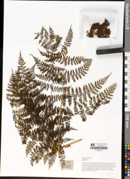
LE 01050132
Peranema aspidioides (Blume) Mett. det. Averyanov, Leonid Vladimirovich at 07.09.2019
Additional identifications: Rumohra sp. ⟮prelim. ID⟯ det. Averyanov, Leonid Vladimirovich at 23.04.2018; Diacalpe sp. det. X.C.Zhang at 05.07.2019 Collectors: Averyanov, Leonid Vladimirovich; Khang Sinh Nguyen; Tien Hiep Nguyen; Nguyen Quang Hieu; Chuong Quang Ngan; Maisak, Tatiana Viktorovna Field collecting number: VR728. Collection date: 23.04.2018. Administrative regions: VN - Tinh Ha Giang. Groups of specimens: L. V. Averyanov specimens; L. V. Averyanov herbarium; L. V. Averyanov photosOriginal label text:FLORA OF VIETNAM Polypodiaceae s.l. Ruhmora sp.? Ha Giang prov., Quan Ba distr., Tung Vai commune, Thang village, around point 23º03ʹ13.4ʺN 104º51ʹ48.8ʺE, steep rocky slopes of stream valley composed with eroded stratified highly eroded limestone at elevation 1000-1200 m a.s.l. Primary evergreen broad-leaved very humid forest. Terrestrial fern in shady flattened place. Common. 23 April 2018, L. Averyanov, Nguyen Sinh Khang, Nguyen Tien Hiep, Nguyen Quang Hieu, Chuong Quang Ngan, T. Maisak, VR 728.
Coordinates (geographic position): 23° 3′ 13.4″ N, 104° 51′ 48.8″ E ±1000 mComment: All photos © L. Averyanov & K.S. Nguyen
Record creation: 2019-04-21, Leonid Averyanov, PhotoScan D1Citation: Specimen LE 01050132 // Virtual herbarium of Komarov Botanical Institute RAS — http://re.herbariumle.ru/01050132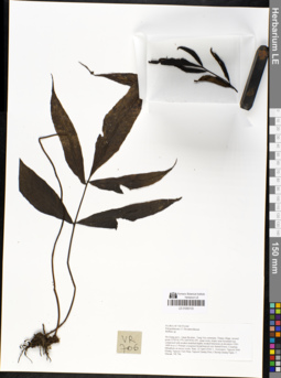
LE 01050133
Bolbitis deltigera (Hook.) C.Chr. det. Averyanov, Leonid Vladimirovich at 22.11.2019
Additional identifications: Bolbitis sp. det. Averyanov, Leonid Vladimirovich at 22.04.2018; Bolbitis heteroclita (Pr.) Ching det. X.C.Zhang at 05.07.2019 Collectors: Averyanov, Leonid Vladimirovich; Khang Sinh Nguyen; Tien Hiep Nguyen; Nguyen Quang Hieu; Chuong Quang Ngan; Maisak, Tatiana Viktorovna Field collecting number: VR706. Collection date: 22.04.2018. Administrative regions: VN - Tinh Ha Giang. Groups of specimens: L. V. Averyanov specimens; L. V. Averyanov herbarium; L. V. Averyanov photosOriginal label text:FLORA OF VIETNAM Polypodiaceae s.l. Dryopteridaceae Bolbitis sp. Ha Giang prov., Quan Ba distr., Tung Vai commune, Thang village, around point 23º03ʹ41.5ʺN 104º50ʹ41.6ʺE, steep rocky slopes near mountain top composed with eroded stratified highly eroded limestone at elevation 1200-1400 m a.s.l. Primary evergreen broad-leaved very humid forest. Creeping lithophyte on mossy rocks. Rare. 22 April 2018, L. Averyanov, Nguyen Sinh Khang, Nguyen Tien Hiep, Nguyen Quang Hieu, Chuong Quang Ngan, T. Maisak, VR 706.
Coordinates (geographic position): 23° 3′ 41.5″ N, 104° 50′ 41.6″ E ±1000 mComment: All photos © L. Averyanov & K.S. Nguyen
Record creation: 2019-04-21, Leonid Averyanov, PhotoScan D1Citation: Specimen LE 01050133 // Virtual herbarium of Komarov Botanical Institute RAS — http://re.herbariumle.ru/01050133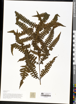
LE 01050134
Dryopteris sp. ⟮prelim. ID⟯ det. Averyanov, Leonid Vladimirovich at 22.04.2018
Collectors: Averyanov, Leonid Vladimirovich; Khang Sinh Nguyen; Tien Hiep Nguyen; Nguyen Quang Hieu; Chuong Quang Ngan; Maisak, Tatiana Viktorovna Field collecting number: VR711. Collection date: 22.04.2018. Administrative regions: VN - Tinh Ha Giang. Groups of specimens: L. V. Averyanov specimens; L. V. Averyanov herbarium; L. V. Averyanov photosOriginal label text:FLORA OF VIETNAM Polypodiaceae s.l. Dryopteris sp.? Ha Giang prov., Quan Ba distr., Tung Vai commune, Thang village, around point 23º03ʹ13.4ʺN 104º51ʹ48.8ʺE, steep rocky slopes of stream valley composed with eroded stratified highly eroded limestone at elevation 1000-1200 m a.s.l. Primary evergreen broad-leaved very humid forest. Terrestrial fern in shady flattened place. Common. 23 April 2018, L. Averyanov, Nguyen Sinh Khang, Nguyen Tien Hiep, Nguyen Quang Hieu, Chuong Quang Ngan, T. Maisak, VR 711.
Coordinates (geographic position): 23° 3′ 13.4″ N, 104° 51′ 48.8″ E ±1000 mComment: All photos © L. Averyanov & K.S. Nguyen
Record creation: 2019-04-21, Leonid Averyanov, PhotoScan D1Citation: Specimen LE 01050134 // Virtual herbarium of Komarov Botanical Institute RAS — http://re.herbariumle.ru/01050134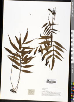
LE 01050137
Leptochilus ellipticus (Thunb.) Noot. det. X.C.Zhang at 05.07.2019
Additional identifications: Colysis digitata Ching ⟮prelim. ID⟯ det. Averyanov, Leonid Vladimirovich at 23.04.2018 Collectors: Averyanov, Leonid Vladimirovich; Khang Sinh Nguyen; Tien Hiep Nguyen; Nguyen Quang Hieu; Chuong Quang Ngan; Maisak, Tatiana Viktorovna Field collecting number: VR735. Collection date: 23.04.2018. Administrative regions: VN - Tinh Ha Giang. Groups of specimens: L. V. Averyanov specimens; L. V. Averyanov herbarium; L. V. Averyanov photosOriginal label text:FLORA OF VIETNAM Polypodiaceae Colysis digitata Ching? Ha Giang prov., Quan Ba distr., Tung Vai commune, Thang village, around point 23º03ʹ13.4ʺN 104º51ʹ48.8ʺE, steep rocky slopes of stream valley composed with eroded stratified highly eroded limestone at elevation 1000-1200 m a.s.l. Primary evergreen broad-leaved very humid forest. Creeping lithophyte on mossy rocks. Common. 23 April 2018, L. Averyanov, Nguyen Sinh Khang, Nguyen Tien Hiep, Nguyen Quang Hieu, Chuong Quang Ngan, T. Maisak, VR 735.
Coordinates (geographic position): 23° 3′ 13.4″ N, 104° 51′ 48.8″ E ±1000 mComment: All photos © L. Averyanov & K.S. Nguyen
Record creation: 2019-04-21, Leonid Averyanov, PhotoScan D1Citation: Specimen LE 01050137 // Virtual herbarium of Komarov Botanical Institute RAS — http://re.herbariumle.ru/01050137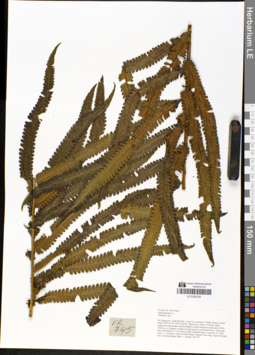
LE 01050139
Cyclosorus truncatus (Poir.) Farw. det. X.C.Zhang at 05.07.2019
Additional identifications: Thelypteris sp. ⟮prelim. ID⟯ det. Averyanov, Leonid Vladimirovich at 23.04.2018 Collectors: Averyanov, Leonid Vladimirovich; Khang Sinh Nguyen; Tien Hiep Nguyen; Nguyen Quang Hieu; Chuong Quang Ngan; Maisak, Tatiana Viktorovna Field collecting number: VR745. Collection date: 23.04.2018. Administrative regions: VN - Tinh Ha Giang. Groups of specimens: L. V. Averyanov specimens; L. V. Averyanov herbarium; L. V. Averyanov photosOriginal label text:FLORA OF VIETNAM Polypodiaceae s.l. Thelipteris sp.? Ha Giang prov., Quan Ba distr., Tung Vai commune, Thang village, around point 23º03ʹ13.4ʺN 104º51ʹ48.8ʺE, steep rocky slopes of stream valley composed with eroded stratified highly eroded limestone at elevation 1000-1200 m a.s.l. Primary evergreen broad-leaved very humid forest. Terrestrial fern with fronds to 1.5 m long in shady flattened place. Common. 23 April 2018, L. Averyanov, Nguyen Sinh Khang, Nguyen Tien Hiep, Nguyen Quang Hieu, Chuong Quang Ngan, T. Maisak, VR 745.
Coordinates (geographic position): 23° 3′ 13.4″ N, 104° 51′ 48.8″ E ±1000 mComment: All photos © L. Averyanov & K.S. Nguyen
Record creation: 2019-04-21, Leonid Averyanov, PhotoScan D1Citation: Specimen LE 01050139 // Virtual herbarium of Komarov Botanical Institute RAS — http://re.herbariumle.ru/01050139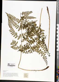
LE 01050140
Dryopteris herbacea Alderw. det. X.C.Zhang at 05.07.2019
Additional identifications: Rumohra sp. ⟮prelim. ID⟯ det. Averyanov, Leonid Vladimirovich at 23.04.2018 Collectors: Averyanov, Leonid Vladimirovich; Khang Sinh Nguyen; Tien Hiep Nguyen; Nguyen Quang Hieu; Chuong Quang Ngan; Maisak, Tatiana Viktorovna Field collecting number: VR748. Collection date: 23.04.2018. Administrative regions: VN - Tinh Ha Giang. Groups of specimens: L. V. Averyanov specimens; L. V. Averyanov herbarium; L. V. Averyanov photosOriginal label text:FLORA OF VIETNAM Polypodiaceae s.l. Ruhmora sp.? Ha Giang prov., Quan Ba distr., Tung Vai commune, Thang village, around point 23º03ʹ13.4ʺN 104º51ʹ48.8ʺE, steep rocky slopes of stream valley composed with eroded stratified highly eroded limestone at elevation 1000-1200 m a.s.l. Primary evergreen broad-leaved very humid forest. Terrestrial fern with fronds to 1 m long in shady flattened place. Common. 23 April 2018, L. Averyanov, Nguyen Sinh Khang, Nguyen Tien Hiep, Nguyen Quang Hieu, Chuong Quang Ngan, T. Maisak, VR 748.
Coordinates (geographic position): 23° 3′ 13.4″ N, 104° 51′ 48.8″ E ±1000 mComment: All photos © L. Averyanov & K.S. Nguyen
Record creation: 2019-04-21, Leonid Averyanov, PhotoScan D1Citation: Specimen LE 01050140 // Virtual herbarium of Komarov Botanical Institute RAS — http://re.herbariumle.ru/01050140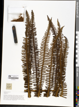
LE 01050142
Cyclosorus erubescens (Hook.) C.M.Kuo det. Averyanov, Leonid Vladimirovich at 21.11.2019
Additional identifications: Thelypteris sp. det. Averyanov, Leonid Vladimirovich at 23.04.2018; Cyclosorus excelsior Ching & K.H. Shing det. X.C.Zhang at 05.07.2019 Collectors: Averyanov, Leonid Vladimirovich; Khang Sinh Nguyen; Tien Hiep Nguyen; Nguyen Quang Hieu; Chuong Quang Ngan; Maisak, Tatiana Viktorovna Field collecting number: VR739. Collection date: 23.04.2018. Administrative regions: VN - Tinh Ha Giang. Groups of specimens: L. V. Averyanov specimens; L. V. Averyanov herbarium; L. V. Averyanov photosOriginal label text:FLORA OF VIETNAM Polypodiaceae s.l. Thelipteris sp. Ha Giang prov., Quan Ba distr., Tung Vai commune, Thang village, around point 23º03ʹ13.4ʺN 104º51ʹ48.8ʺE, steep rocky slopes of stream valley composed with eroded stratified highly eroded limestone at elevation 1000-1200 m a.s.l. Primary evergreen broad-leaved very humid forest. Terrestrial fern with fronds to 1.5 m long in shady flattened place. Common. 23 April 2018, L. Averyanov, Nguyen Sinh Khang, Nguyen Tien Hiep, Nguyen Quang Hieu, Chuong Quang Ngan, T. Maisak, VR 739.
Coordinates (geographic position): 23° 3′ 13.4″ N, 104° 51′ 48.8″ E ±1000 mComment: All photos © L. Averyanov & K.S. Nguyen
Record creation: 2019-04-21, Leonid Averyanov, PhotoScan D1Citation: Specimen LE 01050142 // Virtual herbarium of Komarov Botanical Institute RAS — http://re.herbariumle.ru/01050142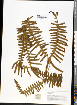
LE 01050151
Dicranopteris ampla Ching & Wang det. X.C.Zhang at 05.07.2019
Additional identifications: Lygodium sp. det. Averyanov, Leonid Vladimirovich at 23.04.2018 Collectors: Averyanov, Leonid Vladimirovich; Khang Sinh Nguyen; Tien Hiep Nguyen; Nguyen Quang Hieu; Chuong Quang Ngan; Maisak, Tatiana Viktorovna Field collecting number: VR766. Collection date: 23.04.2018. Administrative regions: VN - Tinh Ha Giang. Groups of specimens: L. V. Averyanov specimens; L. V. Averyanov herbarium; L. V. Averyanov photosOriginal label text:FLORA OF VIETNAM Polypodiaceae s.l. Lygodium sp. Ha Giang prov., Quan Ba distr., Tung Vai commune, Thang village, around point 23º03ʹ13.4ʺN 104º51ʹ48.8ʺE, steep rocky slopes of stream valley composed with eroded stratified highly eroded limestone at elevation 1000-1200 m a.s.l. Primary evergreen broad-leaved very humid forest. Terrestrial fern with vine-like fronds 2-3 m long in open rocky river slope. Very common in degraded secondary plant communities. 23 April 2018, L. Averyanov, Nguyen Sinh Khang, Nguyen Tien Hiep, Nguyen Quang Hieu, Chuong Quang Ngan, T. Maisak, VR 766.
Coordinates (geographic position): 23° 3′ 13.4″ N, 104° 51′ 48.8″ E ±1000 mComment: All photos © L. Averyanov & K.S. Nguyen
Record creation: 2019-04-21, Leonid Averyanov, PhotoScan D1Citation: Specimen LE 01050151 // Virtual herbarium of Komarov Botanical Institute RAS — http://re.herbariumle.ru/01050151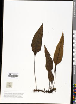
LE 01050157
Neolepisorus ovatus (C.Presl) Ching det. X.C.Zhang at 05.07.2019
Additional identifications: Polypodiaceae sp. ⟮s. l.⟯ det. Averyanov, Leonid Vladimirovich at 24.04.2018 Collectors: Averyanov, Leonid Vladimirovich; Khang Sinh Nguyen; Tien Hiep Nguyen; Nguyen Quang Hieu; Chuong Quang Ngan; Maisak, Tatiana Viktorovna Field collecting number: VR797. Collection date: 24.04.2018. Administrative regions: VN - Tinh Ha Giang. Groups of specimens: L. V. Averyanov specimens; L. V. Averyanov herbarium; L. V. Averyanov photosOriginal label text:FLORA OF VIETNAM Polypodiaceae s.l. Ha Giang prov., Quan Ba distr., Tung Vai commune, Thang village, around point 23º03ʹ04.2ʺN 104º51ʹ09.7ʺE, steep rocky slopes near mountain top composed with eroded stratified highly eroded limestone at elevation 1200-1450 m a.s.l. Primary evergreen broad-leaved very humid forest. Creeping lithophytic fern on exposed mossy rocks. Common. 24 April 2018, L. Averyanov, Nguyen Sinh Khang, Nguyen Tien Hiep, Nguyen Quang Hieu, Chuong Quang Ngan, T. Maisak, VR 797.
Coordinates (geographic position): 23° 3′ 4.2″ N, 104° 51′ 9.7″ E ±1000 mComment: All photos © L. Averyanov & K.S. Nguyen
Record creation: 2019-04-21, Leonid Averyanov, PhotoScan D1Citation: Specimen LE 01050157 // Virtual herbarium of Komarov Botanical Institute RAS — http://re.herbariumle.ru/01050157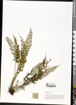
LE 01050164
Asplenium prolongatum Hook. det. Averyanov, Leonid Vladimirovich at 22.04.2018
Collectors: Averyanov, Leonid Vladimirovich; Khang Sinh Nguyen; Tien Hiep Nguyen; Nguyen Quang Hieu; Chuong Quang Ngan; Maisak, Tatiana Viktorovna Field collecting number: VR704. Collection date: 22.04.2018. Administrative regions: VN - Tinh Ha Giang. Groups of specimens: L. V. Averyanov specimens; L. V. Averyanov herbarium; L. V. Averyanov photosOriginal label text:FLORA OF VIETNAM Polypodiaceae s.l. Asplenium prolongatum Hook. Ha Giang prov., Quan Ba distr., Tung Vai commune, Thang village, around point 23º03ʹ41.5ʺN 104º50ʹ41.6ʺE, steep rocky slopes near mountain top composed with eroded stratified highly eroded limestone at elevation 1200-1400 m a.s.l. Primary evergreen broad-leaved very humid forest. Epiphyte on mossy tree in shady place. Very common. 22 April 2018, L. Averyanov, Nguyen Sinh Khang, Nguyen Tien Hiep, Nguyen Quang Hieu, Chuong Quang Ngan, T. Maisak, VR 704.
Coordinates (geographic position): 23° 3′ 41.5″ N, 104° 50′ 41.6″ E ±1000 mComment: All photos © L. Averyanov & K.S. Nguyen
Record creation: 2019-04-21, Leonid Averyanov, PhotoScan D1Citation: Specimen LE 01050164 // Virtual herbarium of Komarov Botanical Institute RAS — http://re.herbariumle.ru/01050164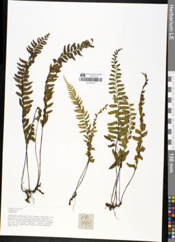
LE 01050170
Hymenasplenium unilaterale (Lam.) Hayata det. X.C.Zhang at 05.07.2019
Additional identifications: Asplenium sp. det. Averyanov, Leonid Vladimirovich at 23.04.2018; Asplenium unilaterale Lam. det. Averyanov, Leonid Vladimirovich at 23.04.2018 Collectors: Averyanov, Leonid Vladimirovich; Khang Sinh Nguyen; Tien Hiep Nguyen; Nguyen Quang Hieu; Chuong Quang Ngan; Maisak, Tatiana Viktorovna Field collecting number: VR716. Collection date: 23.04.2018. Administrative regions: VN - Tinh Ha Giang. Groups of specimens: L. V. Averyanov specimens; L. V. Averyanov herbarium; L. V. Averyanov photosOriginal label text:FLORA OF VIETNAM Polypodiaceae s.l. Asplenium sp. Ha Giang prov., Quan Ba distr., Tung Vai commune, Thang village, around point 23º03ʹ13.4ʺN 104º51ʹ48.8ʺE, steep rocky slopes of stream valley composed with eroded stratified highly eroded limestone at elevation 1000-1200 m a.s.l. Primary evergreen broad-leaved very humid forest. Lithophytic fern on moss rocks. Common. 23 April 2018, L. Averyanov, Nguyen Sinh Khang, Nguyen Tien Hiep, Nguyen Quang Hieu, Chuong Quang Ngan, T. Maisak, VR 716.
Coordinates (geographic position): 23° 3′ 13.4″ N, 104° 51′ 48.8″ E ±1000 mComment: All photos © L. Averyanov & K.S. Nguyen
Record creation: 2019-04-21, Leonid Averyanov, PhotoScan D1Citation: Specimen LE 01050170 // Virtual herbarium of Komarov Botanical Institute RAS — http://re.herbariumle.ru/01050170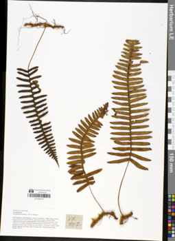
LE 01050173
Polypodium bourretti C. Chr. & Tardieu ⟮prelim. ID⟯ det. Averyanov, Leonid Vladimirovich at 22.04.2018
Collectors: Averyanov, Leonid Vladimirovich; Khang Sinh Nguyen; Tien Hiep Nguyen; Nguyen Quang Hieu; Chuong Quang Ngan; Maisak, Tatiana Viktorovna Field collecting number: VR707. Collection date: 22.04.2018. Administrative regions: VN - Tinh Ha Giang. Groups of specimens: L. V. Averyanov specimens; L. V. Averyanov herbarium; L. V. Averyanov photosOriginal label text:FLORA OF VIETNAM Polypodiaceae Polypodium bourretti C. Chr. & Tardieu? Ha Giang prov., Quan Ba distr., Tung Vai commune, Thang village, around point 23º03ʹ13.4ʺN 104º51ʹ48.8ʺE, steep rocky slopes of stream valley composed with eroded stratified highly eroded limestone at elevation 1000-1200 m a.s.l. Primary evergreen broad-leaved very humid forest. Creeping epiphyte on mossy tree. Not rare. 23 April 2018, L. Averyanov, Nguyen Sinh Khang, Nguyen Tien Hiep, Nguyen Quang Hieu, Chuong Quang Ngan, T. Maisak, VR 707.
Coordinates (geographic position): 23° 3′ 13.4″ N, 104° 51′ 48.8″ E ±1000 mComment: All photos © L. Averyanov & K.S. Nguyen
Record creation: 2019-04-21, Leonid Averyanov, PhotoScan D1Citation: Specimen LE 01050173 // Virtual herbarium of Komarov Botanical Institute RAS — http://re.herbariumle.ru/01050173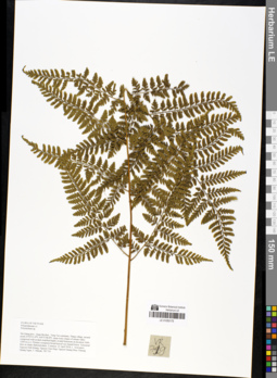
LE 01050175
Dryopteris hasseltii (Blume) C.Chr. det. Averyanov, Leonid Vladimirovich at 07.09.2019
Additional identifications: Polystichum sp. det. Averyanov, Leonid Vladimirovich at 23.04.2018; Dryopteris sp. det. X.C.Zhang at 05.07.2019 Collectors: Averyanov, Leonid Vladimirovich; Khang Sinh Nguyen; Tien Hiep Nguyen; Nguyen Quang Hieu; Chuong Quang Ngan; Maisak, Tatiana Viktorovna Field collecting number: VR719. Collection date: 23.04.2018. Administrative regions: VN - Tinh Ha Giang. Groups of specimens: L. V. Averyanov specimens; L. V. Averyanov herbarium; L. V. Averyanov photosOriginal label text:FLORA OF VIETNAM Polypodiaceae s.l. Polystichum sp. Ha Giang prov., Quan Ba distr., Tung Vai commune, Thang village, around point 23º03ʹ13.4ʺN 104º51ʹ48.8ʺE, steep rocky slopes of stream valley composed with eroded stratified highly eroded limestone at elevation 1000-1200 m a.s.l. Primary evergreen broad-leaved very humid forest. Terrestrial fern on shady flattened place. Common. 23 April 2018, L. Averyanov, Nguyen Sinh Khang, Nguyen Tien Hiep, Nguyen Quang Hieu, Chuong Quang Ngan, T. Maisak, VR 719.
Coordinates (geographic position): 23° 3′ 13.4″ N, 104° 51′ 48.8″ E ±1000 mComment: All photos © L. Averyanov & K.S. Nguyen
Record creation: 2019-04-21, Leonid Averyanov, PhotoScan D1Citation: Specimen LE 01050175 // Virtual herbarium of Komarov Botanical Institute RAS — http://re.herbariumle.ru/01050175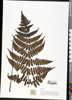
LE 01050176
Cornopteris opaca D.Don det. X.C.Zhang at 05.07.2019
Additional identifications: Diplazium sp. det. Averyanov, Leonid Vladimirovich at 23.04.2018 Collectors: Averyanov, Leonid Vladimirovich; Khang Sinh Nguyen; Tien Hiep Nguyen; Nguyen Quang Hieu; Chuong Quang Ngan; Maisak, Tatiana Viktorovna Field collecting number: VR726. Collection date: 23.04.2018. Administrative regions: VN - Tinh Ha Giang. Groups of specimens: L. V. Averyanov specimens; L. V. Averyanov herbarium; L. V. Averyanov photosOriginal label text:FLORA OF VIETNAM Polypodiaceae s.l. Diplazium sp. Ha Giang prov., Quan Ba distr., Tung Vai commune, Thang village, around point 23º03ʹ13.4ʺN 104º51ʹ48.8ʺE, steep rocky slopes of stream valley composed with eroded stratified highly eroded limestone at elevation 1000-1200 m a.s.l. Primary evergreen broad-leaved very humid forest. Terrestrial fern in open flattened place. Common. 23 April 2018, L. Averyanov, Nguyen Sinh Khang, Nguyen Tien Hiep, Nguyen Quang Hieu, Chuong Quang Ngan, T. Maisak, VR 726.
Coordinates (geographic position): 23° 3′ 13.4″ N, 104° 51′ 48.8″ E ±1000 mComment: All photos © L. Averyanov & K.S. Nguyen
Record creation: 2019-04-21, Leonid Averyanov, PhotoScan D1Citation: Specimen LE 01050176 // Virtual herbarium of Komarov Botanical Institute RAS — http://re.herbariumle.ru/01050176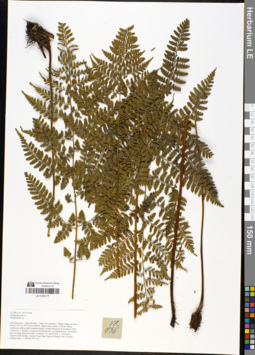
LE 01050177
Dryopteris herbacea Alderw. det. X.C.Zhang at 05.07.2019
Additional identifications: Polystichum sp. det. Averyanov, Leonid Vladimirovich at 23.04.2018 Collectors: Averyanov, Leonid Vladimirovich; Khang Sinh Nguyen; Tien Hiep Nguyen; Nguyen Quang Hieu; Chuong Quang Ngan; Maisak, Tatiana Viktorovna Field collecting number: VR736. Collection date: 23.04.2018. Administrative regions: VN - Tinh Ha Giang. Groups of specimens: L. V. Averyanov specimens; L. V. Averyanov herbarium; L. V. Averyanov photosOriginal label text:FLORA OF VIETNAM Polypodiaceae s.l. Polystichum sp. Ha Giang prov., Quan Ba distr., Tung Vai commune, Thang village, around point 23º03ʹ13.4ʺN 104º51ʹ48.8ʺE, steep rocky slopes of stream valley composed with eroded stratified highly eroded limestone at elevation 1000-1200 m a.s.l. Primary evergreen broad-leaved very humid forest. Terrestrial fern in shady flattened place. Common. 23 April 2018, L. Averyanov, Nguyen Sinh Khang, Nguyen Tien Hiep, Nguyen Quang Hieu, Chuong Quang Ngan, T. Maisak, VR 736.
Coordinates (geographic position): 23° 3′ 13.4″ N, 104° 51′ 48.8″ E ±1000 mComment: All photos © L. Averyanov & K.S. Nguyen
Record creation: 2019-04-21, Leonid Averyanov, PhotoScan D1Citation: Specimen LE 01050177 // Virtual herbarium of Komarov Botanical Institute RAS — http://re.herbariumle.ru/01050177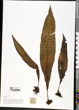
LE 01050179
Neolepisorus fortunei (T.Moore) Li Wang det. X.C.Zhang at 05.07.2019
Additional identifications: Lepisorus sp. det. Averyanov, Leonid Vladimirovich at 23.04.2018 Collectors: Averyanov, Leonid Vladimirovich; Khang Sinh Nguyen; Tien Hiep Nguyen; Nguyen Quang Hieu; Chuong Quang Ngan; Maisak, Tatiana Viktorovna Field collecting number: VR746. Collection date: 23.04.2018. Administrative regions: VN - Tinh Ha Giang. Groups of specimens: L. V. Averyanov specimens; L. V. Averyanov herbarium; L. V. Averyanov photosOriginal label text:FLORA OF VIETNAM Polypodiaceae s.l. Lepisorus sp.? Ha Giang prov., Quan Ba distr., Tung Vai commune, Thang village, around point 23º03ʹ13.4ʺN 104º51ʹ48.8ʺE, steep rocky slopes of stream valley composed with eroded stratified highly eroded limestone at elevation 1000-1200 m a.s.l. Primary evergreen broad-leaved very humid forest. Creeping lithophyte on open mossy rocks. Common. 23 April 2018, L. Averyanov, Nguyen Sinh Khang, Nguyen Tien Hiep, Nguyen Quang Hieu, Chuong Quang Ngan, T. Maisak, VR 746.
Coordinates (geographic position): 23° 3′ 13.4″ N, 104° 51′ 48.8″ E ±1000 mComment: All photos © L. Averyanov & K.S. Nguyen
Record creation: 2019-04-21, Leonid Averyanov, PhotoScan D1Citation: Specimen LE 01050179 // Virtual herbarium of Komarov Botanical Institute RAS — http://re.herbariumle.ru/01050179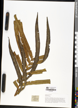
LE 01050180
Blechnum orientale L. det. Averyanov, Leonid Vladimirovich at 23.04.2018
Collectors: Averyanov, Leonid Vladimirovich; Khang Sinh Nguyen; Tien Hiep Nguyen; Nguyen Quang Hieu; Chuong Quang Ngan; Maisak, Tatiana Viktorovna Field collecting number: VR749. Collection date: 23.04.2018. Administrative regions: VN - Tinh Ha Giang. Groups of specimens: L. V. Averyanov specimens; L. V. Averyanov herbarium; L. V. Averyanov photosOriginal label text:FLORA OF VIETNAM Polypodiaceae s.l. Blechnum orientale L. Ha Giang prov., Quan Ba distr., Tung Vai commune, Thang village, around point 23º03ʹ13.4ʺN 104º51ʹ48.8ʺE, steep rocky slopes of stream valley composed with eroded stratified highly eroded limestone at elevation 1000-1200 m a.s.l. Primary evergreen broad-leaved very humid forest. Terrestrial fern with fronds to 1.5 m long on steep open slope. Very common. 23 April 2018, L. Averyanov, Nguyen Sinh Khang, Nguyen Tien Hiep, Nguyen Quang Hieu, Chuong Quang Ngan, T. Maisak, VR 749.
Coordinates (geographic position): 23° 3′ 13.4″ N, 104° 51′ 48.8″ E ±1000 mComment: All photos © L. Averyanov & K.S. Nguyen
Record creation: 2019-04-21, Leonid Averyanov, PhotoScan D1Citation: Specimen LE 01050180 // Virtual herbarium of Komarov Botanical Institute RAS — http://re.herbariumle.ru/01050180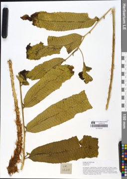
LE 01050325
Tectaria herpetocaulos Holttum det. Averyanov, Leonid Vladimirovich at 07.09.2019
Additional identifications: Dryopteris sp. ⟮prelim. ID⟯ det. Averyanov, Leonid Vladimirovich at 22.10.2018; Tectaria sp. det. Averyanov, Leonid Vladimirovich at 07.09.2019 Collectors: Averyanov, Leonid Vladimirovich; Khang Sinh Nguyen; Maisak, Tatiana Viktorovna; Truong Duc Thieu Field collecting number: VR1220. Collection date: 22.10.2018. Administrative regions: VN - Tinh Ha Giang. Groups of specimens: L. V. Averyanov specimens; L. V. Averyanov herbarium; L. V. Averyanov photosOriginal label text:FLORA OF VIETNAM
Coordinates (geographic position): 23° 5′ 52.6″ N, 104° 51′ 26.4″ E ±1000 mComment: Polypodiaceae s.l.
Dryopteris sp.?
Ha Giang prov., Quan Ba distr., Cao Ma Po commune, Va Thang 1 village, around point 23º05ʹ52.6ʺN 104º51ʹ26.4ʺE, steep alluvial slopes and flattened mountain summits based on limestone at elevation 1400–1480 m a.s.l. Primary evergreen broad-leaved very humid forest. Terrestrial fern on steep shady slope. Common. 22 October 2018, L. Averyanov, Nguyen Sinh Khang, T. Maisak, Truong Duc Thieu, VR 1220.
All photos © L. Averyanov & K.S. Nguyen
Record creation: 2019-05-09, Leonid Averyanov, PhotoScan D1Citation: Specimen LE 01050325 // Virtual herbarium of Komarov Botanical Institute RAS — http://re.herbariumle.ru/01050325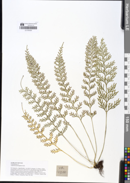
LE 01050329
Asplenium prolongatum Hook. det. Averyanov, Leonid Vladimirovich at 22.10.2018
Collectors: Averyanov, Leonid Vladimirovich; Khang Sinh Nguyen; Maisak, Tatiana Viktorovna; Truong Duc Thieu Field collecting number: VR1200. Collection date: 22.10.2018. Administrative regions: VN - Tinh Ha Giang. Groups of specimens: L. V. Averyanov specimens; L. V. Averyanov herbarium; L. V. Averyanov photosOriginal label text:FLORA OF VIETNAM Polypodiaceae s.l. Asplenium prolongatum Hook. Ha Giang prov., Quan Ba distr., Cao Ma Po commune, Va Thang 1 village, around point 23º05ʹ52.6ʺN 104º51ʹ26.4ʺE, steep alluvial slopes and flattened mountain summits based on limestone at elevation 1400–1480 m a.s.l. Primary evergreen broad-leaved very humid forest. Epiphyte on mossy trees in shady place. Very common. 22 October 2018, L. Averyanov, Nguyen Sinh Khang, T. Maisak, Truong Duc Thieu, VR 1200.
Coordinates (geographic position): 23° 5′ 52.6″ N, 104° 51′ 26.4″ E ±1000 mComment: All photos © L. Averyanov & K.S. Nguyen
Record creation: 2019-05-09, Leonid Averyanov, PhotoScan D1Citation: Specimen LE 01050329 // Virtual herbarium of Komarov Botanical Institute RAS — http://re.herbariumle.ru/01050329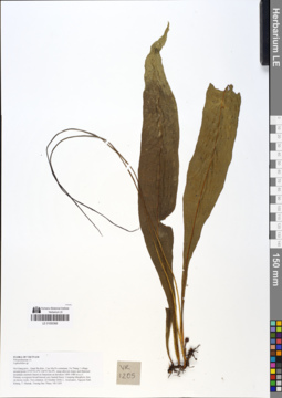
LE 01050368
Leptochilus axillaris (Cav.) Kaulf. det. X.C.Zhang at 05.07.2019
Additional identifications: Leptochilus sp. det. Averyanov, Leonid Vladimirovich at 22.10.2018 Collectors: Averyanov, Leonid Vladimirovich; Khang Sinh Nguyen; Maisak, Tatiana Viktorovna; Truong Duc Thieu Field collecting number: VR1205. Collection date: 22.10.2018. Administrative regions: VN - Tinh Ha Giang. Groups of specimens: L. V. Averyanov specimens; L. V. Averyanov herbarium; L. V. Averyanov photosOriginal label text:FLORA OF VIETNAM
Coordinates (geographic position): 23° 5′ 52.6″ N, 104° 51′ 26.4″ E ±1000 mComment: Polypodiaceae s.l.
Leptochilus sp.
Ha Giang prov., Quan Ba distr., Cao Ma Po commune, Va Thang 1 village, around point 23º05ʹ52.6ʺN 104º51ʹ26.4ʺE, steep alluvial slopes and flattened mountain summits based on limestone at elevation 1400–1480 m a.s.l. Primary evergreen broad-leaved very humid forest. Creeping lithophytic fern on mossy rocks. Not common. 22 October 2018, L. Averyanov, Nguyen Sinh Khang, T. Maisak, Truong Duc Thieu, VR 1205.
All photos © L. Averyanov & K.S. Nguyen
Record creation: 2019-05-09, Leonid Averyanov, PhotoScan D1Citation: Specimen LE 01050368 // Virtual herbarium of Komarov Botanical Institute RAS — http://re.herbariumle.ru/01050368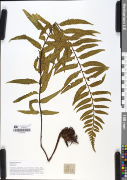
LE 01050406
Asplenium wrightii Hook. det. Averyanov, Leonid Vladimirovich at 04.07.2019
Additional identifications: Asplenium sp. det. Averyanov, Leonid Vladimirovich at 22.10.2018 Collectors: Averyanov, Leonid Vladimirovich; Khang Sinh Nguyen; Maisak, Tatiana Viktorovna; Truong Duc Thieu Field collecting number: VR1212. Collection date: 22.10.2018. Administrative regions: VN - Tinh Ha Giang. Groups of specimens: L. V. Averyanov specimens; L. V. Averyanov herbarium; L. V. Averyanov photosOriginal label text:FLORA OF VIETNAM
Coordinates (geographic position): 23° 5′ 52.6″ N, 104° 51′ 26.4″ E ±1000 mComment: Polypodiaceae s.l.
Asplenium sp.
Ha Giang prov., Quan Ba distr., Cao Ma Po commune, Va Thang 1 village, around point 23º05ʹ52.6ʺN 104º51ʹ26.4ʺE, steep alluvial slopes and flattened mountain summits based on limestone at elevation 1400–1480 m a.s.l. Primary evergreen broad-leaved very humid forest. Terrestrial fern on steep mossy shady slope. Very common. 22 October 2018, L. Averyanov, Nguyen Sinh Khang, T. Maisak, Truong Duc Thieu, VR 1212.
All photos © L. Averyanov & K.S. Nguyen
Record creation: 2019-05-09, Leonid Averyanov, PhotoScan D1Citation: Specimen LE 01050406 // Virtual herbarium of Komarov Botanical Institute RAS — http://re.herbariumle.ru/01050406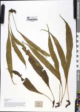
LE 01050448
Microsorum normale (D.Don) Ching det. X.C.Zhang at 05.07.2019
Additional identifications: Microsorum sp. det. Averyanov, Leonid Vladimirovich at 22.10.2018 Collectors: Averyanov, Leonid Vladimirovich; Khang Sinh Nguyen; Maisak, Tatiana Viktorovna; Truong Duc Thieu Field collecting number: VR1202. Collection date: 22.10.2018. Administrative regions: VN - Tinh Ha Giang. Groups of specimens: L. V. Averyanov specimens; L. V. Averyanov herbarium; L. V. Averyanov photosOriginal label text:FLORA OF VIETNAM
Coordinates (geographic position): 23° 5′ 52.6″ N, 104° 51′ 26.4″ E ±1000 mComment: Polypodiaceae s.l.
Microsorum sp.
Ha Giang prov., Quan Ba distr., Cao Ma Po commune, Va Thang 1 village, around point 23º05ʹ52.6ʺN 104º51ʹ26.4ʺE, steep alluvial slopes and flattened mountain summits based on limestone at elevation 1400–1480 m a.s.l. Primary evergreen broad-leaved very humid forest. Creeping epiphyte on mossy trees. Common. 22 October 2018, L. Averyanov, Nguyen Sinh Khang, T. Maisak, Truong Duc Thieu, VR 1202.
All photos © L. Averyanov & K.S. Nguyen
Record creation: 2019-05-09, Leonid Averyanov, PhotoScan D1Citation: Specimen LE 01050448 // Virtual herbarium of Komarov Botanical Institute RAS — http://re.herbariumle.ru/01050448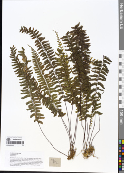
LE 01054140
Hymenasplenium cheilosorum (Mett.) Tag. det. X.C.Zhang at 05.07.2019
Additional identifications: Asplenium sp. det. Averyanov, Leonid Vladimirovich at 17.10.2018 Collectors: Averyanov, Leonid Vladimirovich; Khang Sinh Nguyen; Maisak, Tatiana Viktorovna; Truong Duc Thieu Field collecting number: VR952. Collection date: 17.10.2018. Administrative regions: VN - Tinh Ha Giang. Groups of specimens: L. V. Averyanov specimens; L. V. Averyanov herbarium; L. V. Averyanov photosOriginal label text:FLORA OF VIETNAM
Coordinates (geographic position): 23° 4′ 28.9″ N, 104° 55′ 32″ E ±1000 mComment: Polypodiaceae s.l.
Asplenium sp.
Ha Giang prov., Quan Ba distr., Tung Vai commune, Thung Pang village, around point 23º04ʹ28.9ʺN 104º55ʹ32.0ʺE, steep rocky slope to large deep cave composed with highly eroded marble-like white limestone at elevation 900–1000 m a.s.l. Secondary evergreen broad-leaved very humid forest with bamboo. Terrestrial and lithophytic fern on shady rocky stream slope. Not rare. 17 October 2018, L. Averyanov, Nguyen Sinh Khang, T. Maisak, Truong Duc Thieu, VR 952.
All photos © L. Averyanov & K.S. Nguyen
Record creation: 2019-05-03, Leonid Averyanov, PhotoScan D1Citation: Specimen LE 01054140 // Virtual herbarium of Komarov Botanical Institute RAS — http://re.herbariumle.ru/01054140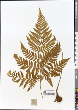
LE 01054145
Hypodematium crenatum Kuhn & Decken det. Averyanov, Leonid Vladimirovich at 07.09.2019
Additional identifications: Tectaria sp. ⟮prelim. ID⟯ det. Averyanov, Leonid Vladimirovich at 17.10.2018 Collectors: Averyanov, Leonid Vladimirovich; Khang Sinh Nguyen; Maisak, Tatiana Viktorovna; Truong Duc Thieu Field collecting number: VR957. Collection date: 17.10.2018. Administrative regions: VN - Tinh Ha Giang. Groups of specimens: L. V. Averyanov specimens; L. V. Averyanov herbarium; L. V. Averyanov photosOriginal label text:FLORA OF VIETNAM
Coordinates (geographic position): 23° 4′ 28.9″ N, 104° 55′ 32″ E ±1000 mComment: Polypodiaceae s.l.
Tectaria sp.?
Ha Giang prov., Quan Ba distr., Tung Vai commune, Thung Pang village, around point 23º04ʹ28.9ʺN 104º55ʹ32.0ʺE, steep rocky slope to large deep cave composed with highly eroded marble-like white limestone at elevation 900–1000 m a.s.l. Secondary evergreen broad-leaved very humid forest with bamboo. Lithophytic fern on vertical shady cliff. Not Rare. 17 October 2018, L. Averyanov, Nguyen Sinh Khang, T. Maisak, Truong Duc Thieu, VR 957.
All photos © L. Averyanov & K.S. Nguyen
Record creation: 2019-05-03, Leonid Averyanov, PhotoScan D1Citation: Specimen LE 01054145 // Virtual herbarium of Komarov Botanical Institute RAS — http://re.herbariumle.ru/01054145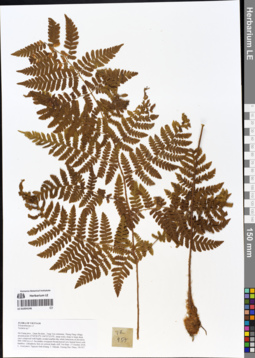
LE 01054146
Hypodematium crenatum Kuhn & Decken det. Averyanov, Leonid Vladimirovich at 07.09.2019
Additional identifications: Tectaria sp. ⟮prelim. ID⟯ det. Averyanov, Leonid Vladimirovich at 17.10.2018; Ctenitis sp. det. X.C.Zhang at 05.07.2019 Collectors: Averyanov, Leonid Vladimirovich; Khang Sinh Nguyen; Maisak, Tatiana Viktorovna; Truong Duc Thieu Field collecting number: VR957. Collection date: 17.10.2018. Administrative regions: VN - Tinh Ha Giang. Groups of specimens: L. V. Averyanov specimens; L. V. Averyanov herbarium; L. V. Averyanov photosOriginal label text:FLORA OF VIETNAM Polypodiaceae s.l. Tectaria sp.? Ha Giang prov., Quan Ba distr., Tung Vai commune, Thung Pang village, around point 23º04ʹ28.9ʺN 104º55ʹ32.0ʺE, steep rocky slope to large deep cave composed with highly eroded marble-like white limestone at elevation 900–1000 m a.s.l. Secondary evergreen broad-leaved very humid forest with bamboo. Lithophytic fern on vertical shady cliff. Not Rare. 17 October 2018, L. Averyanov, Nguyen Sinh Khang, T. Maisak, Truong Duc Thieu, VR 957.
Coordinates (geographic position): 23° 4′ 28.9″ N, 104° 55′ 32″ E ±1000 mComment: All photos © L. Averyanov & K.S. Nguyen
Record creation: 2019-05-03, Leonid Averyanov, PhotoScan D1Citation: Specimen LE 01054146 // Virtual herbarium of Komarov Botanical Institute RAS — http://re.herbariumle.ru/01054146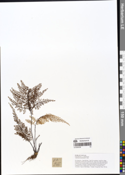
LE 01054158
Asplenium pulcherrimum (Baker) Ching det. X.C.Zhang at 05.07.2019
Additional identifications: Asplenium tenuifolium D. Don det. Averyanov, Leonid Vladimirovich at 18.10.2018 Collectors: Averyanov, Leonid Vladimirovich; Khang Sinh Nguyen; Maisak, Tatiana Viktorovna; Truong Duc Thieu Field collecting number: VR966. Collection date: 18.10.2018. Administrative regions: VN - Tinh Ha Giang. Groups of specimens: L. V. Averyanov specimens; L. V. Averyanov herbarium; L. V. Averyanov photosOriginal label text:FLORA OF VIETNAM
Coordinates (geographic position): 23° 2′ 55″ N, 104° 56′ 1.4″ E ±1000 mComment: Polypodiaceae s.l.
Aspleniaceae
Asplenium tenuifolium D. Don
Ha Giang prov., Quan Ba distr., Tung Vai commune, Lung Kho village, around point 23º02ʹ55.0ʺN 104º56ʹ01.4ʺE, steep rocky slopes near hill top composed with stratified highly eroded limestone at elevation 900–980 m a.s.l. Remnants of primary evergreen broad-leaved very humid forest. Lithophytic fern on shady mossy cliff. Not rare. 18 October 2018, L. Averyanov, Nguyen Sinh Khang, T. Maisak, Truong Duc Thieu, VR 966.
All photos © L. Averyanov & K.S. Nguyen
Record creation: 2019-05-03, Leonid Averyanov, PhotoScan D1Citation: Specimen LE 01054158 // Virtual herbarium of Komarov Botanical Institute RAS — http://re.herbariumle.ru/01054158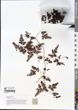
LE 01054166
Lygodium japonicum (Thunb.) Sw. ⟮prelim. ID⟯ det. Averyanov, Leonid Vladimirovich at 18.10.2018
Collectors: Averyanov, Leonid Vladimirovich; Khang Sinh Nguyen; Maisak, Tatiana Viktorovna; Truong Duc Thieu Field collecting number: VR974. Collection date: 18.10.2018. Administrative regions: VN - Tinh Ha Giang. Groups of specimens: L. V. Averyanov specimens; L. V. Averyanov herbarium; L. V. Averyanov photosOriginal label text:FLORA OF VIETNAM Polypodiaceae s.l. Lygodium japonicum (Thunb.) Sw.? Ha Giang prov., Quan Ba distr., Tung Vai commune, Lung Kho village, around point 23º02ʹ55.0ʺN 104º56ʹ01.4ʺE, steep rocky slopes near hill top composed with stratified highly eroded limestone at elevation 900–980 m a.s.l. Remnants of primary evergreen broad-leaved very humid forest. Terrestrial fern with vine fronds to 6 m long in open place. Common. 18 October 2018, L. Averyanov, Nguyen Sinh Khang, T. Maisak, Truong Duc Thieu, VR 974.
Coordinates (geographic position): 23° 2′ 55″ N, 104° 56′ 1.4″ E ±1000 mComment: All photos © L. Averyanov & K.S. Nguyen
Record creation: 2019-05-03, Leonid Averyanov, PhotoScan D1Citation: Specimen LE 01054166 // Virtual herbarium of Komarov Botanical Institute RAS — http://re.herbariumle.ru/01054166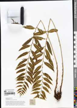
LE 01054167
Cyrtogonellum fraxinellum (Christ) Ching det. Averyanov, Leonid Vladimirovich at 18.10.2018
Collectors: Averyanov, Leonid Vladimirovich; Khang Sinh Nguyen; Maisak, Tatiana Viktorovna; Truong Duc Thieu Field collecting number: VR976. Collection date: 18.10.2018. Administrative regions: VN - Tinh Ha Giang. Groups of specimens: L. V. Averyanov specimens; L. V. Averyanov herbarium; L. V. Averyanov photosOriginal label text:FLORA OF VIETNAM Polypodiaceae s.l. Cyrtogonellum fraxinellum (Christ) Ching Ha Giang prov., Quan Ba distr., Tung Vai commune, Lung Kho village, around point 23º02ʹ55.0ʺN 104º56ʹ01.4ʺE, steep rocky slopes near hill top composed with stratified highly eroded limestone at elevation 900–980 m a.s.l. Remnants of primary evergreen broad-leaved very humid forest. Terrestrial fern on shady rocky slope. Common. 18 October 2018, L. Averyanov, Nguyen Sinh Khang, T. Maisak, Truong Duc Thieu, VR 976.
Coordinates (geographic position): 23° 2′ 55″ N, 104° 56′ 1.4″ E ±1000 mComment: All photos © L. Averyanov & K.S. Nguyen
Record creation: 2019-05-03, Leonid Averyanov, PhotoScan D1Citation: Specimen LE 01054167 // Virtual herbarium of Komarov Botanical Institute RAS — http://re.herbariumle.ru/01054167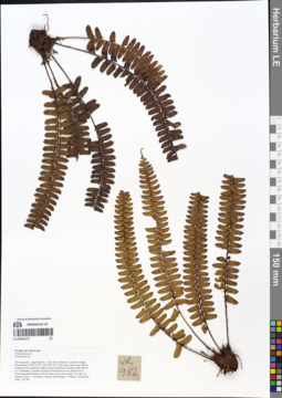
LE 01054173
Polystichum dielsii Christ det. Averyanov, Leonid Vladimirovich at 07.09.2019
Additional identifications: Polystichum sp. det. Averyanov, Leonid Vladimirovich at 18.10.2018 Collectors: Averyanov, Leonid Vladimirovich; Khang Sinh Nguyen; Maisak, Tatiana Viktorovna; Truong Duc Thieu Field collecting number: VR982. Collection date: 18.10.2018. Administrative regions: VN - Tinh Ha Giang. Groups of specimens: L. V. Averyanov specimens; L. V. Averyanov herbarium; L. V. Averyanov photosOriginal label text:FLORA OF VIETNAM
Coordinates (geographic position): 23° 2′ 55″ N, 104° 56′ 1.4″ E ±1000 mComment: Polypodiaceae s.l.
Polystichum sp.
Ha Giang prov., Quan Ba distr., Tung Vai commune, Lung Kho village, around point 23º02ʹ55.0ʺN 104º56ʹ01.4ʺE, steep rocky slopes near hill top composed with stratified highly eroded limestone at elevation 900–980 m a.s.l. Remnants of primary evergreen broad-leaved very humid forest. Terrestrial and lithophytic fern on steep rocky mossy slope. Not rare. 18 October 2018, L. Averyanov, Nguyen Sinh Khang, T. Maisak, Truong Duc Thieu, VR 982.
All photos © L. Averyanov & K.S. Nguyen
Record creation: 2019-05-03, Leonid Averyanov, PhotoScan D1Citation: Specimen LE 01054173 // Virtual herbarium of Komarov Botanical Institute RAS — http://re.herbariumle.ru/01054173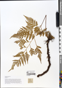
LE 01054346
Davallia solida (G. Forst.) Sw. det. X.C.Zhang at 05.07.2019
Additional identifications: Davallia sp. det. Averyanov, Leonid Vladimirovich at 16.04.2018 Collectors: Averyanov, Leonid Vladimirovich; Khang Sinh Nguyen; Chuong Quang Ngan; Maisak, Tatiana Viktorovna Field collecting number: VR278. Collection date: 16.04.2018. Administrative regions: VN - Tinh Ha Giang. Groups of specimens: L. V. Averyanov specimens; L. V. Averyanov herbarium; L. V. Averyanov photosOriginal label text:FLORA OF VIETNAM Polypodiaceae s.l. Davallia sp. Ha Giang prov., Quan Ba distr., Bat Dai Son Nature Reserve, Bat Dai Son commune, Pai Chu Phin village, around point 23º07ʹ54.9ʺN 104º59ʹ24.1ʺE, 1000-1220 m a.s.l., karstic, highly eroded mountains composed of solid marble-like limestone, primary evergreen broad-leaved and coniferous (with Pseudotsuga sinensis) humid forest on steep rocky slopes near mountain tops. Creeping epiphyte and occasionally lithophyte on rocky mountain top. Common. 16 April 2018, L. Averyanov, Nguyen Sinh Khang, Chuong Quang Ngan, T. Maisak, VR 278.
Comment: All photos © L. Averyanov & K.S. Nguyen
Record creation: 2019-05-03, Leonid Averyanov, PhotoScan D1Citation: Specimen LE 01054346 // Virtual herbarium of Komarov Botanical Institute RAS — http://re.herbariumle.ru/01054346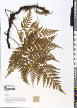
LE 01054347
Davallia solida (G. Forst.) Sw. det. X.C.Zhang at 05.07.2019
Additional identifications: Davallia sp. det. Averyanov, Leonid Vladimirovich at 16.04.2018 Collectors: Averyanov, Leonid Vladimirovich; Khang Sinh Nguyen; Chuong Quang Ngan; Maisak, Tatiana Viktorovna Field collecting number: VR278. Collection date: 16.04.2018. Administrative regions: VN - Tinh Ha Giang. Groups of specimens: L. V. Averyanov specimens; L. V. Averyanov herbarium; L. V. Averyanov photosOriginal label text:FLORA OF VIETNAM Polypodiaceae s.l. Davallia sp. Ha Giang prov., Quan Ba distr., Bat Dai Son Nature Reserve, Bat Dai Son commune, Pai Chu Phin village, around point 23º07ʹ54.9ʺN 104º59ʹ24.1ʺE, 1000-1220 m a.s.l., karstic, highly eroded mountains composed of solid marble-like limestone, primary evergreen broad-leaved and coniferous (with Pseudotsuga sinensis) humid forest on steep rocky slopes near mountain tops. Creeping epiphyte and occasionally lithophyte on rocky mountain top. Common. 16 April 2018, L. Averyanov, Nguyen Sinh Khang, Chuong Quang Ngan, T. Maisak, VR 278.
Comment: All photos © L. Averyanov & K.S. Nguyen
Record creation: 2019-05-03, Leonid Averyanov, PhotoScan D1Citation: Specimen LE 01054347 // Virtual herbarium of Komarov Botanical Institute RAS — http://re.herbariumle.ru/01054347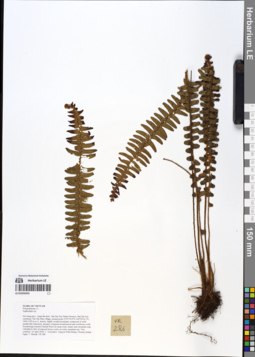
LE 01054355
Nephrolepis auriculata (L.) Trimen det. X.C.Zhang at 05.07.2019
Additional identifications: Nephrolepis sp. det. Averyanov, Leonid Vladimirovich at 16.04.2018 Collectors: Averyanov, Leonid Vladimirovich; Khang Sinh Nguyen; Chuong Quang Ngan; Maisak, Tatiana Viktorovna Field collecting number: VR286. Collection date: 16.04.2018. Administrative regions: VN - Tinh Ha Giang. Groups of specimens: L. V. Averyanov specimens; L. V. Averyanov herbarium; L. V. Averyanov photosOriginal label text:FLORA OF VIETNAM Polypodiaceae s.l. Nephrolepis sp. Ha Giang prov., Quan Ba distr., Bat Dai Son Nature Reserve, Bat Dai Son commune, Pai Chu Phin village, around point 23º07ʹ54.9ʺN 104º59ʹ24.1ʺE, 1000-1220 m a.s.l., karstic, highly eroded mountains composed of solid marble-like limestone, primary evergreen broad-leaved and coniferous (with Pseudotsuga sinensis) humid forest on steep rocky slopes near mountain tops. Lithophytic fern of exposed mossy rocks on rocky mountain top. Very common. 16 April 2018, L. Averyanov, Nguyen Sinh Khang, Chuong Quang Ngan, T. Maisak, VR 286.
Comment: All photos © L. Averyanov & K.S. Nguyen
Record creation: 2019-05-03, Leonid Averyanov, PhotoScan D1Citation: Specimen LE 01054355 // Virtual herbarium of Komarov Botanical Institute RAS — http://re.herbariumle.ru/01054355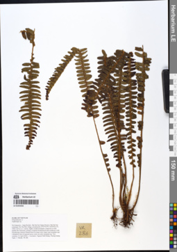
LE 01054356
Nephrolepis auriculata (L.) Trimen det. X.C.Zhang at 05.07.2019
Additional identifications: Nephrolepis sp. det. Averyanov, Leonid Vladimirovich at 16.04.2018 Collectors: Averyanov, Leonid Vladimirovich; Khang Sinh Nguyen; Chuong Quang Ngan; Maisak, Tatiana Viktorovna Field collecting number: VR286. Collection date: 16.04.2018. Administrative regions: VN - Tinh Ha Giang. Groups of specimens: L. V. Averyanov specimens; L. V. Averyanov herbarium; L. V. Averyanov photosOriginal label text:FLORA OF VIETNAM Polypodiaceae s.l. Nephrolepis sp. Ha Giang prov., Quan Ba distr., Bat Dai Son Nature Reserve, Bat Dai Son commune, Pai Chu Phin village, around point 23º07ʹ54.9ʺN 104º59ʹ24.1ʺE, 1000-1220 m a.s.l., karstic, highly eroded mountains composed of solid marble-like limestone, primary evergreen broad-leaved and coniferous (with Pseudotsuga sinensis) humid forest on steep rocky slopes near mountain tops. Lithophytic fern of exposed mossy rocks on rocky mountain top. Very common. 16 April 2018, L. Averyanov, Nguyen Sinh Khang, Chuong Quang Ngan, T. Maisak, VR 286.
Comment: All photos © L. Averyanov & K.S. Nguyen
Record creation: 2019-05-03, Leonid Averyanov, PhotoScan D1Citation: Specimen LE 01054356 // Virtual herbarium of Komarov Botanical Institute RAS — http://re.herbariumle.ru/01054356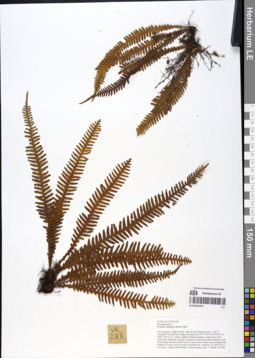
LE 01054357
Prosaptia barathrophylla (Baker) M.G.Price det. Averyanov, Leonid Vladimirovich at 15.02.2020
Additional identifications: Prosaptia obliquata (Blume) Mett. det. Averyanov, Leonid Vladimirovich at 16.04.2018; Prosaptia khasyana (Hook.) C.Chr. & Tard. det. X.C.Zhang at 05.07.2019 Collectors: Averyanov, Leonid Vladimirovich; Khang Sinh Nguyen; Chuong Quang Ngan; Maisak, Tatiana Viktorovna Field collecting number: VR288. Collection date: 16.04.2018. Administrative regions: VN - Tinh Ha Giang. Groups of specimens: L. V. Averyanov specimens; L. V. Averyanov herbarium; L. V. Averyanov photosOriginal label text:FLORA OF VIETNAM Polypodiaceae s.l. Prosaptia obliquata (Blume) Mett. Ha Giang prov., Quan Ba distr., Bat Dai Son Nature Reserve, Bat Dai Son commune, Pai Chu Phin village, around point 23º07ʹ54.9ʺN 104º59ʹ24.1ʺE, 1000-1220 m a.s.l., karstic, highly eroded mountains composed of solid marble-like limestone, primary evergreen broad-leaved and coniferous (with Pseudotsuga sinensis) humid forest on steep rocky slopes near mountain tops. Epiphyte on mossy trees on rocky mountain top. Common. 16 April 2018, L. Averyanov, Nguyen Sinh Khang, Chuong Quang Ngan, T. Maisak, VR 288.
Comment: All photos © L. Averyanov & K.S. Nguyen
Record creation: 2019-05-03, Leonid Averyanov, PhotoScan D1Citation: Specimen LE 01054357 // Virtual herbarium of Komarov Botanical Institute RAS — http://re.herbariumle.ru/01054357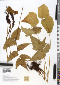
LE 01054443
Cyrtomium hemionitis Christ det. X.C.Zhang at 05.07.2019
Additional identifications: Cyrtomium fortunei J. Sm. det. Averyanov, Leonid Vladimirovich at 14.04.2018 Collectors: Averyanov, Leonid Vladimirovich; Khang Sinh Nguyen; Chuong Quang Ngan; Maisak, Tatiana Viktorovna Field collecting number: VR128. Collection date: 14.04.2018. Administrative regions: VN - Tinh Ha Giang. Groups of specimens: L. V. Averyanov specimens; L. V. Averyanov herbarium; L. V. Averyanov photosOriginal label text:FLORA OF VIETNAM Polypodiaceae s.l. Dryopteridaceae Cyrtomium fortunei J. Sm. Ha Giang prov., Quan Ba distr., Bat Dai Son Nature Reserve, Can Ty commune, Dau Cau 1 village, around point 23º05ʹ26.3ʺN 105º01ʹ03.0ʺE, 1100-1150 m a.s.l., karstic, highly eroded mountains composed of solid marble-like limestone, primary evergreen broad-leaved humid forest on steep rocky slopes near mountain tops. Terrestrial and lithophytic rosulate fern on very steep slope. Not rare. 14 April 2018, L. Averyanov, Nguyen Sinh Khang, Chuong Quang Ngan, T. Maisak, VR 128.
Comment: All photos © L. Averyanov & K.S. Nguyen
Record creation: 2019-05-03, Leonid Averyanov, PhotoScan D1Citation: Specimen LE 01054443 // Virtual herbarium of Komarov Botanical Institute RAS — http://re.herbariumle.ru/01054443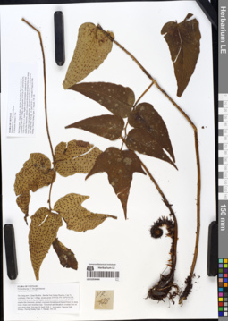
LE 01054444
Cyrtomium hemionitis Christ det. X.C.Zhang at 05.07.2019
Additional identifications: Cyrtomium fortunei J. Sm. det. Averyanov, Leonid Vladimirovich at 14.04.2018 Collectors: Averyanov, Leonid Vladimirovich; Khang Sinh Nguyen; Chuong Quang Ngan; Maisak, Tatiana Viktorovna Field collecting number: VR128. Collection date: 14.04.2018. Administrative regions: VN - Tinh Ha Giang. Groups of specimens: L. V. Averyanov specimens; L. V. Averyanov herbarium; L. V. Averyanov photosOriginal label text:FLORA OF VIETNAM Polypodiaceae s.l. Dryopteridaceae Cyrtomium fortunei J. Sm. Ha Giang prov., Quan Ba distr., Bat Dai Son Nature Reserve, Can Ty commune, Dau Cau 1 village, around point 23º05ʹ26.3ʺN 105º01ʹ03.0ʺE, 1100-1150 m a.s.l., karstic, highly eroded mountains composed of solid marble-like limestone, primary evergreen broad-leaved humid forest on steep rocky slopes near mountain tops. Terrestrial and lithophytic rosulate fern on very steep slope. Not rare. 14 April 2018, L. Averyanov, Nguyen Sinh Khang, Chuong Quang Ngan, T. Maisak, VR 128.
Comment: All photos © L. Averyanov & K.S. Nguyen
Record creation: 2019-05-03, Leonid Averyanov, PhotoScan D1Citation: Specimen LE 01054444 // Virtual herbarium of Komarov Botanical Institute RAS — http://re.herbariumle.ru/01054444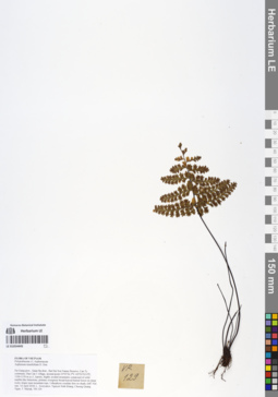
LE 01054445
Asplenium dianguiense X.C.Zhang det. X.C.Zhang at 05.07.2019
Additional identifications: Asplenium tenuifolium D. Don det. Averyanov, Leonid Vladimirovich at 14.04.2018 Collectors: Averyanov, Leonid Vladimirovich; Khang Sinh Nguyen; Chuong Quang Ngan; Maisak, Tatiana Viktorovna Field collecting number: VR129. Collection date: 14.04.2018. Administrative regions: VN - Tinh Ha Giang. Groups of specimens: L. V. Averyanov specimens; L. V. Averyanov herbarium; L. V. Averyanov photosOriginal label text:FLORA OF VIETNAM Polypodiaceae s.l. Aspleniaceae Asplenium tenuifolium D. Don Ha Giang prov., Quan Ba distr., Bat Dai Son Nature Reserve, Can Ty commune, Dau Cau 1 village, around point 23º05ʹ26.3ʺN 105º01ʹ03.0ʺE, 1100-1150 m a.s.l., karstic, highly eroded mountains composed of solid marble-like limestone, primary evergreen broad-leaved humid forest on steep rocky slopes near mountain tops. Lithophytic rosulate fern on shady cliff. Not rare. 14 April 2018, L. Averyanov, Nguyen Sinh Khang, Chuong Quang Ngan, T. Maisak, VR 129.
Comment: All photos © L. Averyanov & K.S. Nguyen
Record creation: 2019-05-03, Leonid Averyanov, PhotoScan D1Citation: Specimen LE 01054445 // Virtual herbarium of Komarov Botanical Institute RAS — http://re.herbariumle.ru/01054445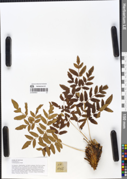
LE 01054615
Osmunda japonica Thunb. det. Averyanov, Leonid Vladimirovich at 20.10.2018
Collectors: Averyanov, Leonid Vladimirovich; Khang Sinh Nguyen; Maisak, Tatiana Viktorovna; Truong Duc Thieu Field collecting number: VR1062. Collection date: 20.10.2018. Administrative regions: VN - Tinh Ha Giang. Groups of specimens: L. V. Averyanov specimens; L. V. Averyanov herbarium; L. V. Averyanov photosOriginal label text:FLORA OF VIETNAM
Coordinates (geographic position): 23° 5′ 13.5″ N, 104° 48′ 30.2″ E ±1000 mComment: Polypodiaceae s.l.
Osmunda japonica Thunb.
Ha Giang prov., Quan Ba distr., Cao Ma Po commune, Chin Chu Lin village, around point 23º05ʹ13.5ʺN 104º48ʹ30.2ʺE, rocky outcrops on steep rocky slopes composed with eroded karstic limestone at elevation 1750–1950 m a.s.l. Highly degraded remnants of primary evergreen broad-leaved very humid forest and evergreen secondary shrubs. Terrestrial fern on wet grassy slope. Occasional. 20 October 2018, L. Averyanov, Nguyen Sinh Khang, T. Maisak, Truong Duc Thieu, VR 1062.
All photos © L. Averyanov & K.S. Nguyen
Record creation: 2019-05-23, Leonid Averyanov, PhotoScan D1Citation: Specimen LE 01054615 // Virtual herbarium of Komarov Botanical Institute RAS — http://re.herbariumle.ru/01054615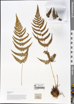
LE 01054639
Polystichum biaristatum (Blume) T. Moore det. Averyanov, Leonid Vladimirovich at 07.09.2019
Additional identifications: Polystichum sp. det. Averyanov, Leonid Vladimirovich at 20.10.2018 Collectors: Averyanov, Leonid Vladimirovich; Khang Sinh Nguyen; Maisak, Tatiana Viktorovna; Truong Duc Thieu Field collecting number: VR1067. Collection date: 20.10.2018. Administrative regions: VN - Tinh Ha Giang. Groups of specimens: L. V. Averyanov specimens; L. V. Averyanov herbarium; L. V. Averyanov photosOriginal label text:FLORA OF VIETNAM
Coordinates (geographic position): 23° 5′ 13.5″ N, 104° 48′ 30.2″ E ±1000 mComment: Polypodiaceae s.l.
Polystichum sp.
Ha Giang prov., Quan Ba distr., Cao Ma Po commune, Chin Chu Lin village, around point 23º05ʹ13.5ʺN 104º48ʹ30.2ʺE, rocky outcrops on steep rocky slopes composed with eroded karstic limestone at elevation 1750–1950 m a.s.l. Highly degraded remnants of primary evergreen broad-leaved very humid forest and evergreen secondary shrubs. Terrestrial and lithophytic fern on open rocky slope. Common. 20 October 2018, L. Averyanov, Nguyen Sinh Khang, T. Maisak, Truong Duc Thieu, VR 1067.
All photos © L. Averyanov & K.S. Nguyen
Record creation: 2019-05-23, Leonid Averyanov, PhotoScan D1Citation: Specimen LE 01054639 // Virtual herbarium of Komarov Botanical Institute RAS — http://re.herbariumle.ru/01054639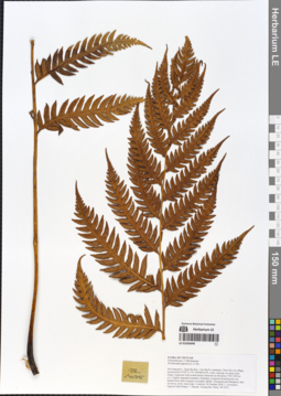
LE 01054648
Woodwardia unigemmata (Makino) Nakai det. X.C.Zhang at 05.07.2019
Additional identifications: Woodwardia japonica (L.f.) Sm. det. Averyanov, Leonid Vladimirovich at 20.10.2018 Collectors: Averyanov, Leonid Vladimirovich; Khang Sinh Nguyen; Maisak, Tatiana Viktorovna; Truong Duc Thieu Field collecting number: VR1075. Collection date: 20.10.2018. Administrative regions: VN - Tinh Ha Giang. Groups of specimens: L. V. Averyanov specimens; L. V. Averyanov herbarium; L. V. Averyanov photosOriginal label text:FLORA OF VIETNAM
Coordinates (geographic position): 23° 5′ 13.5″ N, 104° 48′ 30.2″ E ±1000 mComment: Polypodiaceae s.l.
Blechnaceae
Woodwardia japonica (L.f.) Sm.
Ha Giang prov., Quan Ba distr., Cao Ma Po commune, Chin Chu Lin village, around point 23º05ʹ13.5ʺN 104º48ʹ30.2ʺE, rocky outcrops on steep rocky slopes composed with eroded karstic limestone at elevation 1750–1950 m a.s.l. Highly degraded remnants of primary evergreen broad-leaved very humid forest and evergreen secondary shrubs. Terrestrial and lithophytic fern on mossy rocky steep slope. Common. 20 October 2018, L. Averyanov, Nguyen Sinh Khang, T. Maisak, Truong Duc Thieu, VR 1075.
All photos © L. Averyanov & K.S. Nguyen
Record creation: 2019-05-23, Leonid Averyanov, PhotoScan D1Citation: Specimen LE 01054648 // Virtual herbarium of Komarov Botanical Institute RAS — http://re.herbariumle.ru/01054648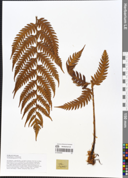
LE 01054649
Woodwardia unigemmata (Makino) Nakai det. X.C.Zhang at 05.07.2019
Additional identifications: Woodwardia japonica (L.f.) Sm. det. Averyanov, Leonid Vladimirovich at 20.10.2018 Collectors: Averyanov, Leonid Vladimirovich; Khang Sinh Nguyen; Maisak, Tatiana Viktorovna; Truong Duc Thieu Field collecting number: VR1075. Collection date: 20.10.2018. Administrative regions: VN - Tinh Ha Giang. Groups of specimens: L. V. Averyanov specimens; L. V. Averyanov herbarium; L. V. Averyanov photosOriginal label text:FLORA OF VIETNAM Polypodiaceae s.l. Blechnaceae Woodwardia japonica (L.f.) Sm. Ha Giang prov., Quan Ba distr., Cao Ma Po commune, Chin Chu Lin village, around point 23º05ʹ13.5ʺN 104º48ʹ30.2ʺE, rocky outcrops on steep rocky slopes composed with eroded karstic limestone at elevation 1750–1950 m a.s.l. Highly degraded remnants of primary evergreen broad-leaved very humid forest and evergreen secondary shrubs. Terrestrial and lithophytic fern on mossy rocky steep slope. Common. 20 October 2018, L. Averyanov, Nguyen Sinh Khang, T. Maisak, Truong Duc Thieu, VR 1075.
Coordinates (geographic position): 23° 5′ 13.5″ N, 104° 48′ 30.2″ E ±1000 mComment: All photos © L. Averyanov & K.S. Nguyen
Record creation: 2019-05-23, Leonid Averyanov, PhotoScan D1Citation: Specimen LE 01054649 // Virtual herbarium of Komarov Botanical Institute RAS — http://re.herbariumle.ru/01054649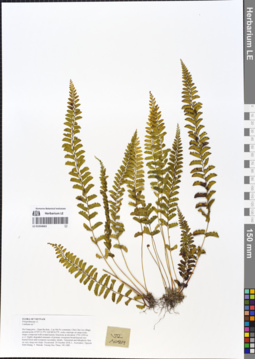
LE 01054663
Osmolindsaea odorata (Roxb.) Lehtonen & Christenh. det. X.C.Zhang at 05.07.2019
Additional identifications: Lindsaea sp. ⟮prelim. ID⟯ det. Averyanov, Leonid Vladimirovich at 20.10.2018 Collectors: Averyanov, Leonid Vladimirovich; Khang Sinh Nguyen; Maisak, Tatiana Viktorovna; Truong Duc Thieu Field collecting number: VR1089. Collection date: 20.10.2018. Administrative regions: VN - Tinh Ha Giang. Groups of specimens: L. V. Averyanov specimens; L. V. Averyanov herbarium; L. V. Averyanov photosOriginal label text:FLORA OF VIETNAM
Coordinates (geographic position): 23° 5′ 13.5″ N, 104° 48′ 30.2″ E ±1000 mComment: Polypodiaceae s.l.
Lindsaea sp.?
Ha Giang prov., Quan Ba distr., Cao Ma Po commune, Chin Chu Lin village, around point 23º05ʹ13.5ʺN 104º48ʹ30.2ʺE, rocky outcrops on steep rocky slopes composed with eroded karstic limestone at elevation 1750–1950 m a.s.l. Highly degraded remnants of primary evergreen broad-leaved very humid forest and evergreen secondary shrubs. Terrestrial and lithophytic fern on very steep wet slope. Occasional. 20 October 2018, L. Averyanov, Nguyen Sinh Khang, T. Maisak, Truong Duc Thieu, VR 1089.
All photos © L. Averyanov & K.S. Nguyen
Record creation: 2019-05-23, Leonid Averyanov, PhotoScan D1Citation: Specimen LE 01054663 // Virtual herbarium of Komarov Botanical Institute RAS — http://re.herbariumle.ru/01054663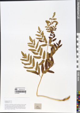
LE 01054668
Osmunda japonica Thunb. det. Averyanov, Leonid Vladimirovich at 20.10.2018
Collectors: Averyanov, Leonid Vladimirovich; Khang Sinh Nguyen; Maisak, Tatiana Viktorovna; Truong Duc Thieu Field collecting number: VR1062. Collection date: 20.10.2018. Administrative regions: VN - Tinh Ha Giang. Groups of specimens: L. V. Averyanov specimens; L. V. Averyanov herbarium; L. V. Averyanov photosOriginal label text:FLORA OF VIETNAM Polypodiaceae s.l. Osmunda japonica Thunb. Ha Giang prov., Quan Ba distr., Cao Ma Po commune, Chin Chu Lin village, around point 23º05ʹ13.5ʺN 104º48ʹ30.2ʺE, rocky outcrops on steep rocky slopes composed with eroded karstic limestone at elevation 1750–1950 m a.s.l. Highly degraded remnants of primary evergreen broad-leaved very humid forest and evergreen secondary shrubs. Terrestrial fern on wet grassy slope. Occasional. 20 October 2018, L. Averyanov, Nguyen Sinh Khang, T. Maisak, Truong Duc Thieu, VR 1062.
Coordinates (geographic position): 23° 5′ 13.5″ N, 104° 48′ 30.2″ E ±1000 mComment: All photos © L. Averyanov & K.S. Nguyen
Record creation: 2019-05-23, Leonid Averyanov, PhotoScan D1Citation: Specimen LE 01054668 // Virtual herbarium of Komarov Botanical Institute RAS — http://re.herbariumle.ru/01054668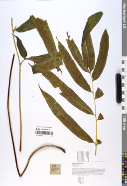
LE 01055338
Coniogramme intermedia Hieron. det. X.C.Zhang at 02.07.2019
Additional identifications: Diplazium sp. det. Averyanov, Leonid Vladimirovich at 21.10.2018 Collectors: Averyanov, Leonid Vladimirovich; Khang Sinh Nguyen; Maisak, Tatiana Viktorovna; Truong Duc Thieu Field collecting number: VR1127. Collection date: 21.10.2018. Administrative regions: VN - Tinh Ha Giang. Groups of specimens: L. V. Averyanov specimens; L. V. Averyanov photos; L. V. Averyanov herbariumOriginal label text:FLORA OF VIETNAM
Coordinates (geographic position): 23° 4′ 47.2″ N, 104° 48′ 55.6″ E ±1000 mComment: Polypodiaceae s.l.
Diplazium sp.
Ha Giang prov., Quan Ba distr., Cao Ma Po commune, Chin Chu Lin village, around point 23º04ʹ47.2ʺN 104º48ʹ55.6ʺE, steep slopes and flattened top of mountain composed with sandstone at elevation 1800–1950 m a.s.l. Primary evergreen broad-leaved very humid forest. Terrestrial fern on steep mossy slope. Not rare. 21 October 2018, L. Averyanov, Nguyen Sinh Khang, T. Maisak, Truong Duc Thieu, VR 1127.
All photos © L. Averyanov & K.S. Nguyen
Record creation: 2019-06-11, Leonid Averyanov, PhotoScan D1Citation: Specimen LE 01055338 // Virtual herbarium of Komarov Botanical Institute RAS — http://re.herbariumle.ru/01055338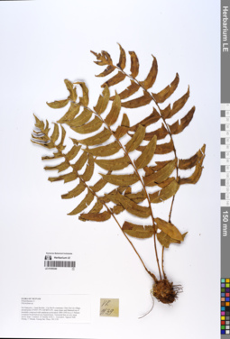
LE 01055340
Polystichum hookerianum (C.Presl) C.Chr. det. Averyanov, Leonid Vladimirovich at 09.07.2019
Additional identifications: Polystichum sp. det. Averyanov, Leonid Vladimirovich at 21.10.2018 Collectors: Averyanov, Leonid Vladimirovich; Khang Sinh Nguyen; Maisak, Tatiana Viktorovna; Truong Duc Thieu Field collecting number: VR1139. Collection date: 21.10.2018. Administrative regions: VN - Tinh Ha Giang. Groups of specimens: L. V. Averyanov specimens; L. V. Averyanov photos; L. V. Averyanov herbariumOriginal label text:FLORA OF VIETNAM
Coordinates (geographic position): 23° 4′ 47.2″ N, 104° 48′ 55.6″ E ±1000 mComment: Polypodiaceae s.l.
Dryopteridaceae
Polystichum hookerianum (C.Presl) C.Chr.
Ha Giang prov., Quan Ba distr., Cao Ma Po commune, Chin Chu Lin village, around point 23º04ʹ47.2ʺN 104º48ʹ55.6ʺE, steep slopes and flattened top of mountain composed with sandstone at elevation 1800–1950 m a.s.l. Primary evergreen broad-leaved very humid forest. Terrestrial fern on very steep mossy slope. Common. 21 October 2018, L. Averyanov, Nguyen Sinh Khang, T. Maisak, Truong Duc Thieu, VR 1139.
All photos © L. Averyanov & K.S. Nguyen
Record creation: 2019-06-11, Leonid Averyanov, PhotoScan D1Citation: Specimen LE 01055340 // Virtual herbarium of Komarov Botanical Institute RAS — http://re.herbariumle.ru/01055340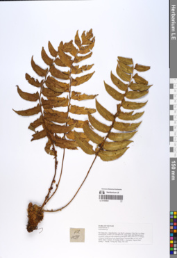
LE 01055341
Polystichum hookerianum (C.Presl) C.Chr. det. Averyanov, Leonid Vladimirovich at 09.07.2019
Additional identifications: Polystichum sp. det. Averyanov, Leonid Vladimirovich at 21.10.2018 Collectors: Averyanov, Leonid Vladimirovich; Khang Sinh Nguyen; Maisak, Tatiana Viktorovna; Truong Duc Thieu Field collecting number: VR1139. Collection date: 21.10.2018. Administrative regions: VN - Tinh Ha Giang. Groups of specimens: L. V. Averyanov specimens; L. V. Averyanov photos; L. V. Averyanov herbariumOriginal label text:FLORA OF VIETNAM Polypodiaceae s.l. Dryopteridaceae Polystichum hookerianum (C.Presl) C.Chr. Ha Giang prov., Quan Ba distr., Cao Ma Po commune, Chin Chu Lin village, around point 23º04ʹ47.2ʺN 104º48ʹ55.6ʺE, steep slopes and flattened top of mountain composed with sandstone at elevation 1800–1950 m a.s.l. Primary evergreen broad-leaved very humid forest. Terrestrial fern on very steep mossy slope. Common. 21 October 2018, L. Averyanov, Nguyen Sinh Khang, T. Maisak, Truong Duc Thieu, VR 1139.
Coordinates (geographic position): 23° 4′ 47.2″ N, 104° 48′ 55.6″ E ±1000 mComment: All photos © L. Averyanov & K.S. Nguyen
Record creation: 2019-06-11, Leonid Averyanov, PhotoScan D1Citation: Specimen LE 01055341 // Virtual herbarium of Komarov Botanical Institute RAS — http://re.herbariumle.ru/01055341