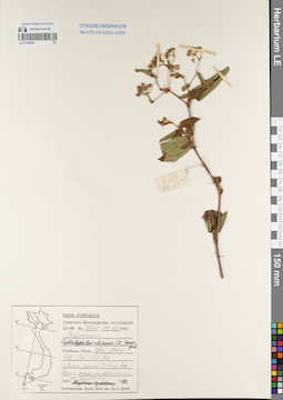
View
Add
Copy
Edit
Delete
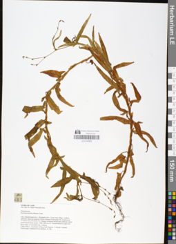
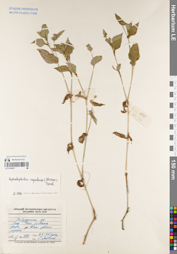
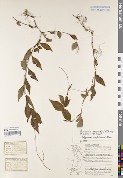
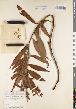
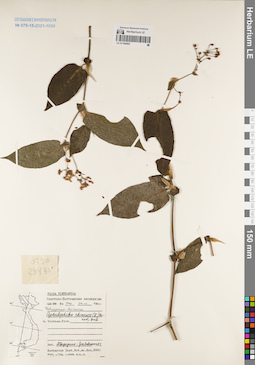
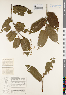
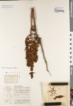
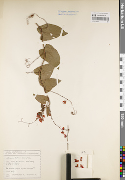
LE 01048593
Persicaria pulchra (Blume) Sojak det. Averyanov, Leonid Vladimirovich at 05.05.2018
Collectors: Averyanov, Leonid Vladimirovich; Khang Sinh Nguyen; Maisak, Tatiana Viktorovna; et al. Field collecting number: AL683. Collection date: 05.05.2018. Administrative regions: LA - Khammouan. Groups of specimens: L. V. Averyanov specimens; L. V. Averyanov herbarium; L. V. Averyanov photosOriginal label text:FLORA OF LAOS Hin Nam No Nature Protected Area Polygonaceae Persicaria pulchra (Blume) Sojak Laos, Khammouane prov., Boualapha distr., Nong Seng village, southern sandstone slopes at summit of Phou Chuang (Poujeuang) Mt. around point 17°35'18.1"N, 105°47'47.5"E. Primary evergreen mixed and coniferous dense wind-formed forest at elev. 1000-1400 m a.s.l. Terrestrial herb in open wet mossy place on mountain top. Common. 5 May 2018, L. Averyanov, Khang Sinh Nguyen, T. Maisak, Littideth Xaiyavongsa, Siphanom Keovankham, AL 683.
Coordinates (geographic position): 17° 35′ 18.1″ N, 105° 47′ 47.5″ E ±1000 mRecord creation: 2019-01-13, Leonid Averyanov, PhotoScan D1Citation: Specimen LE 01048593 // Virtual herbarium of Komarov Botanical Institute RAS — http://re.herbariumle.ru/01048593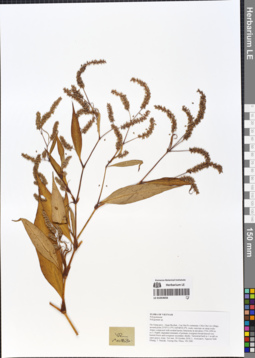
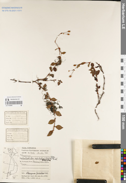
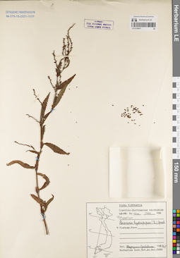
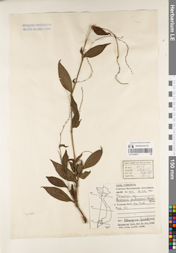
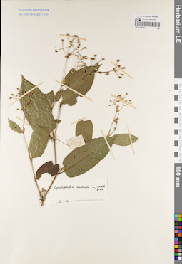
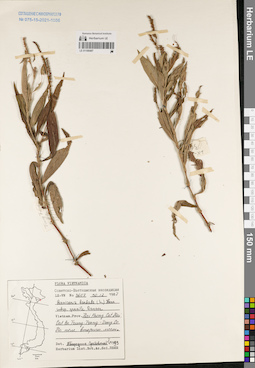
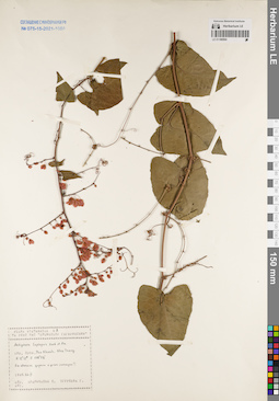
LE 01054656
Persicaria lapathifolia (L.) Gray det. Grabovskaja-Borodina, Alisa Evgenievna at 15.01.2020
Additional identifications: Polygonum sp. det. Averyanov, Leonid Vladimirovich at 20.10.2018 Collectors: Averyanov, Leonid Vladimirovich; Khang Sinh Nguyen; Maisak, Tatiana Viktorovna; Truong Duc Thieu Field collecting number: VR1083. Collection date: 20.10.2018. Administrative regions: VN - Tinh Ha Giang. Groups of specimens: L. V. Averyanov specimens; L. V. Averyanov herbarium; L. V. Averyanov photosOriginal label text:FLORA OF VIETNAM
Coordinates (geographic position): 23° 5′ 13.5″ N, 104° 48′ 30.2″ E ±1000 mComment: Polygonaceae
Polygonum sp.
Ha Giang prov., Quan Ba distr., Cao Ma Po commune, Chin Chu Lin village, around point 23º05ʹ13.5ʺN 104º48ʹ30.2ʺE, rocky outcrops on steep rocky slopes composed with eroded karstic limestone at elevation 1750–1950 m a.s.l. Highly degraded remnants of primary evergreen broad-leaved very humid forest and evergreen secondary shrubs. Terrestrial herb to 1 m tall on open grassy slope. Not rare. 20 October 2018, L. Averyanov, Nguyen Sinh Khang, T. Maisak, Truong Duc Thieu, VR 1083.
All photos © L. Averyanov & K.S. Nguyen
Record creation: 2019-05-23, Leonid Averyanov, PhotoScan D1Citation: Specimen LE 01054656 // Virtual herbarium of Komarov Botanical Institute RAS — http://re.herbariumle.ru/01054656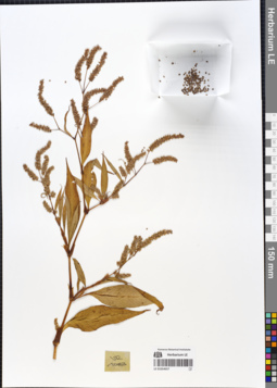
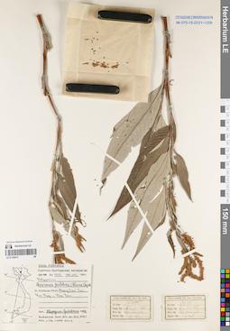
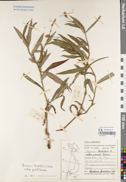
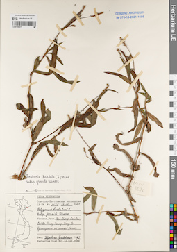
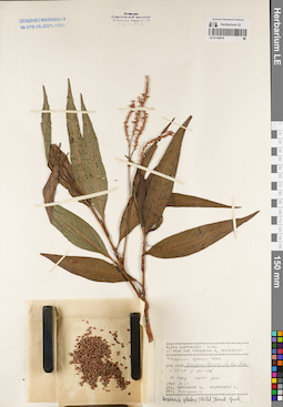
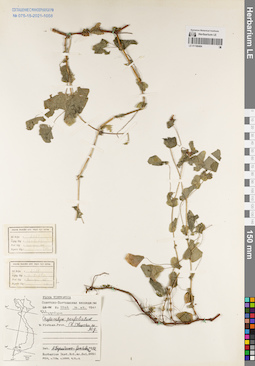
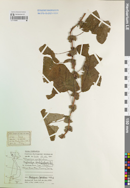
LE 01054657
Persicaria lapathifolia (L.) Gray det. Grabovskaja-Borodina, Alisa Evgenievna at 15.01.2020
Additional identifications: Polygonum sp. det. Averyanov, Leonid Vladimirovich at 20.10.2018 Collectors: Averyanov, Leonid Vladimirovich; Khang Sinh Nguyen; Maisak, Tatiana Viktorovna; Truong Duc Thieu Field collecting number: VR1083. Collection date: 20.10.2018. Administrative regions: VN - Tinh Ha Giang. Groups of specimens: L. V. Averyanov specimens; L. V. Averyanov herbarium; L. V. Averyanov photosOriginal label text:FLORA OF VIETNAM Polygonaceae Polygonum sp. Ha Giang prov., Quan Ba distr., Cao Ma Po commune, Chin Chu Lin village, around point 23º05ʹ13.5ʺN 104º48ʹ30.2ʺE, rocky outcrops on steep rocky slopes composed with eroded karstic limestone at elevation 1750–1950 m a.s.l. Highly degraded remnants of primary evergreen broad-leaved very humid forest and evergreen secondary shrubs. Terrestrial herb to 1 m tall on open grassy slope. Not rare. 20 October 2018, L. Averyanov, Nguyen Sinh Khang, T. Maisak, Truong Duc Thieu, VR 1083.
Coordinates (geographic position): 23° 5′ 13.5″ N, 104° 48′ 30.2″ E ±1000 mComment: All photos © L. Averyanov & K.S. Nguyen
Record creation: 2019-05-23, Leonid Averyanov, PhotoScan D1Citation: Specimen LE 01054657 // Virtual herbarium of Komarov Botanical Institute RAS — http://re.herbariumle.ru/01054657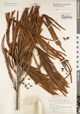
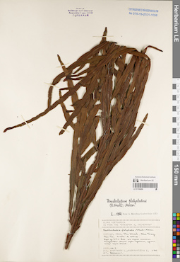
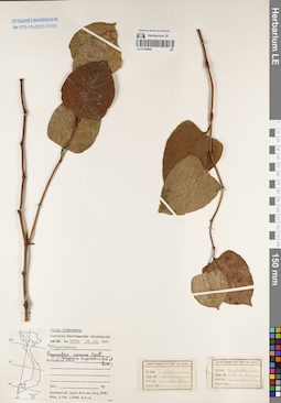
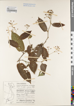
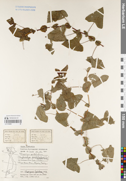
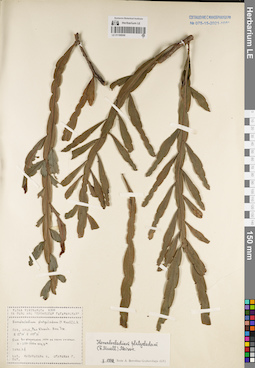
LE 01168465
Homalocladium platycladum (F.J. Müll.) L.H. Bailey det. Averyanov, Leonid Vladimirovich at 27.07.2022
Additional identifications: Muehlenbeckia platyclada (F.Muell.) Meisn. det. Averyanov, Leonid Vladimirovich at 06.11.1989 Collectors: Averyanov, Leonid Vladimirovich; Kudryavtzeva, Ekaterina Field collecting number: Averyanov 095. Collection date: 06.11.1989. Administrative regions: VN - Tinh Khanh Hoa. Groups of specimens: L. V. Averyanov specimens; L. V. Averyanov herbarium; Соглашение Минобрнауки №075-15-2021-1056Original label text:FLORA OF VIETNAM
Record creation: 2022-06-04, Galina Savich, PhotoScan D2. Processing status: work_status_1Citation: Specimen LE 01168465 // Virtual herbarium of Komarov Botanical Institute RAS — http://re.herbariumle.ru/01168465Polygonaceae
Muehlenbeckia platyclada (F.Muell.) Meisn.
Khanh Hoa Prov.
06.11.1989, Averyanov L., Kudryavtzeva E.
Averyanov 095
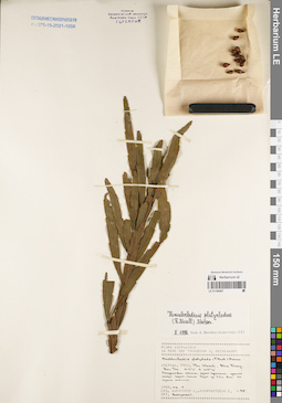
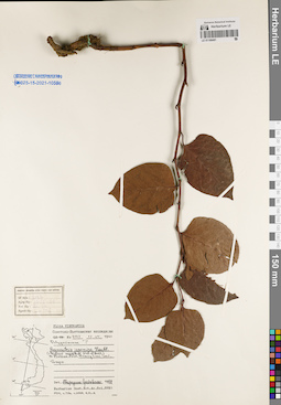
LE 01168466
Homalocladium platycladum (F.J. Müll.) L.H. Bailey det. Grabovskaja-Borodina, Alisa Evgenievna at 02.1992
Collectors: Averyanov, Leonid Vladimirovich; Kudryavtzeva, Ekaterina Field collecting number: Averyanov 095. Collection date: 06.11.1989. Administrative regions: VN - Tinh Khanh Hoa. Groups of specimens: L. V. Averyanov specimens; L. V. Averyanov herbarium; Соглашение Минобрнауки №075-15-2021-1056Original label text:FLORA OF VIETNAM
Record creation: 2022-06-04, Galina Savich, PhotoScan D2. Processing status: work_status_1Citation: Specimen LE 01168466 // Virtual herbarium of Komarov Botanical Institute RAS — http://re.herbariumle.ru/01168466Polygonaceae
Homalocladium platycladum (F.J. Müll.) L.H. Bailey.
Khanh Hoa Prov.
06.11.1989, Averyanov L., Kudryavtzeva E.
Averyanov 095
Det. Grabovskaja-Borodina, Alisa Evgenievna at 02.1992
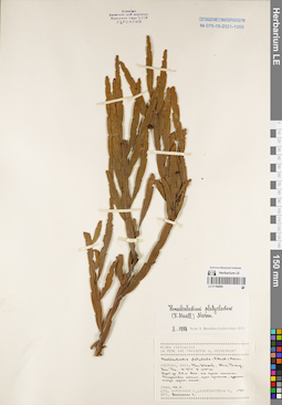
LE 01168467
Homalocladium platycladum (F.J. Müll.) L.H. Bailey det. Grabovskaja-Borodina, Alisa Evgenievna at 06.11.1989
Collectors: Averyanov, Leonid Vladimirovich; Kudryavtzeva, Ekaterina Field collecting number: Averyanov 095. Collection date: 06.11.1989. Administrative regions: VN - Tinh Khanh Hoa. Groups of specimens: L. V. Averyanov specimens; L. V. Averyanov herbarium; Соглашение Минобрнауки №075-15-2021-1056Original label text:FLORA OF VIETNAM
Record creation: 2022-06-04, Galina Savich, PhotoScan D2. Processing status: work_status_1Citation: Specimen LE 01168467 // Virtual herbarium of Komarov Botanical Institute RAS — http://re.herbariumle.ru/01168467Polygonaceae
Homalocladium platycladum (F.J. Müll.) L.H. Bailey.
Khanh Hoa Prov.
06.11.1989, Averyanov L., Kudryavtzeva E.
Averyanov 095
Det. Grabovskaja-Borodina, Alisa Evgenievna at 02.1992
LE 01168468
Homalocladium platycladum (F.J. Müll.) L.H. Bailey det. Grabovskaja-Borodina, Alisa Evgenievna at 02.1992
Collectors: Averyanov, Leonid Vladimirovich; Kudryavtzeva, Ekaterina Field collecting number: Averyanov 095. Collection date: 06.11.1989. Administrative regions: VN - Tinh Khanh Hoa. Groups of specimens: L. V. Averyanov specimens; L. V. Averyanov herbarium; Соглашение Минобрнауки №075-15-2021-1056Original label text:FLORA OF VIETNAM
Record creation: 2022-06-04, Galina Savich, PhotoScan D2. Processing status: work_status_1Citation: Specimen LE 01168468 // Virtual herbarium of Komarov Botanical Institute RAS — http://re.herbariumle.ru/01168468Polygonaceae
Homalocladium platycladum (F.J. Müll.) L.H. Bailey.
Khanh Hoa Prov.
06.11.1989, Averyanov L., Kudryavtzeva E.
Averyanov 095
Det. Grabovskaja-Borodina, Alisa Evgenievna at 02.1992
LE 01168469
Cephalophilon capitatum (Buch.-Ham. ex D.Don) Tzvelev det. Grabovskaja-Borodina, Alisa Evgenievna at 1992
Collectors: Unknown Field collecting number: N 2304. Collection date: 18.05.1961. Administrative regions: VN - Tinh Lao Cai. Groups of specimens: L. V. Averyanov specimens; L. V. Averyanov herbarium; Соглашение Минобрнауки №075-15-2021-1056Original label text:FLORA OF VIETNAM
Polygonaceae
Cephalophilon capitatum (Buch.-Ham. ex D.Don) Tzvelev.
Lao Cai Prov.
18.05.1961, N 2304
Det. Grabovskaja-Borodina, Alisa Evgenievna at 1992
LE 01168470
Cephalophilon nepalense (Meisn.) Tzvelev det. Grabovskaja-Borodina, Alisa Evgenievna at 02.1992
Collectors: Yakovlev, Gennady Pavlovich Field collecting number: LX-VN 789. Collection date: 13.06.1981. Administrative regions: VN - Tinh Vinh Phuc. Groups of specimens: L. V. Averyanov specimens; L. V. Averyanov herbarium; Соглашение Минобрнауки №075-15-2021-1056Original label text:FLORA OF VIETNAM
Record creation: 2022-06-04, Galina Savich, PhotoScan D2. Processing status: work_status_1Citation: Specimen LE 01168470 // Virtual herbarium of Komarov Botanical Institute RAS — http://re.herbariumle.ru/01168470Polygonaceae
Cephalophilon nepalense (Meisn.) Tzvelev.
Tinh Vinh Phuc Prov.
13.06.1981, Yakovlev G. LX-VN 789
Det. Grabovskaja-Borodina, Alisa Evgenievna at 02.1992
LE 01168471
Persicaria hydropiper (L.) Delarbre det. Grabovskaja-Borodina, Alisa Evgenievna at 04.1992
Collectors: Unknown Field collecting number: sn.. Collection date: 1963. Administrative regions: VN - Vietnam. Groups of specimens: L. V. Averyanov specimens; L. V. Averyanov herbarium; Соглашение Минобрнауки №075-15-2021-1056Original label text:FLORA OF VIETNAM
Record creation: 2022-06-04, Galina Savich, PhotoScan D2. Processing status: work_status_1Citation: Specimen LE 01168471 // Virtual herbarium of Komarov Botanical Institute RAS — http://re.herbariumle.ru/01168471Polygonaceae
Persicaria hydropiper (L.) Delarbre.
Vietnam. 1963, sn.
Det. Grabovskaja-Borodina, Alisa Evgenievna at 04.1992
LE 01168472
Persicaria pulchra (Blume) Sojak det. Grabovskaja-Borodina, Alisa Evgenievna at 1992
Collectors: Unknown Field collecting number: N 1975. Collection date: 06.05.1961. Administrative regions: VN - Tinh Lao Cai. Groups of specimens: L. V. Averyanov specimens; L. V. Averyanov herbarium; Соглашение Минобрнауки №075-15-2021-1056Original label text:FLORA OF VIETNAM
Record creation: 2022-06-04, Galina Savich, PhotoScan D2. Processing status: work_status_1Citation: Specimen LE 01168472 // Virtual herbarium of Komarov Botanical Institute RAS — http://re.herbariumle.ru/01168472Polygonaceae
Persicaria pulchra (Blume) Sojak.
06.05.1961, N 1975.
Det. Grabovskaja-Borodina, Alisa Evgenievna at 1992
LE 01168473
Persicaria posumbu (Buch.-Ham. ex D. Don) H. Gross det. Grabovskaja-Borodina, Alisa Evgenievna at 1992
Collectors: Unknown Field collecting number: N 3366. Collection date: 23.12.1986. Administrative regions: VN - Thanh Pho Hai Phong. Groups of specimens: L. V. Averyanov specimens; L. V. Averyanov herbarium; Соглашение Минобрнауки №075-15-2021-1056Original label text:FLORA OF VIETNAM
Record creation: 2022-06-04, Galina Savich, PhotoScan D2. Processing status: work_status_1Citation: Specimen LE 01168473 // Virtual herbarium of Komarov Botanical Institute RAS — http://re.herbariumle.ru/01168473Polygonaceae
Persicaria posumbu (Buch.-Ham. ex D. Don) H. Gross.
Hai Phong Prov.
23.12.1986, N 3366
Det. Grabovskaja-Borodina, Alisa Evgenievna at 1992
LE 01168474
Persicaria posumbu (Buch.-Ham. ex D. Don) H. Gross det. Grabovskaja-Borodina, Alisa Evgenievna at 11.1992
Collectors: Unknown Field collecting number: N 1749. Collection date: 04.05.1961. Administrative regions: VN - Tinh Lai Chau. Groups of specimens: L. V. Averyanov specimens; L. V. Averyanov herbarium; Соглашение Минобрнауки №075-15-2021-1056Original label text:FLORA OF VIETNAM
Record creation: 2022-06-04, Galina Savich, PhotoScan D2. Processing status: work_status_1Citation: Specimen LE 01168474 // Virtual herbarium of Komarov Botanical Institute RAS — http://re.herbariumle.ru/01168474Polygonaceae
Persicaria posumbu (Buch.-Ham. ex D. Don) H. Gross.
Lai Chau Prov.
04.05.1961, N 1749
Det. Grabovskaja-Borodina, Alisa Evgenievna at 11.1992
LE 01168475
Persicaria pubescens (Blume) H. Hara det. Grabovskaja-Borodina, Alisa Evgenievna at 1992
Collectors: Unknown Field collecting number: N 4115. Collection date: 18.09.1961. Administrative regions: VN - Tinh Ha Tinh. Groups of specimens: L. V. Averyanov specimens; L. V. Averyanov herbarium; Соглашение Минобрнауки №075-15-2021-1056Original label text:FLORA OF VIETNAM
Record creation: 2022-06-04, Galina Savich, PhotoScan D2. Processing status: work_status_1Citation: Specimen LE 01168475 // Virtual herbarium of Komarov Botanical Institute RAS — http://re.herbariumle.ru/01168475Polygonaceae
Persicaria pubescens (Blume) H. Hara.
Ha Tinh Prov.
18.09.1961, N 4115
Det. Grabovskaja-Borodina, Alisa Evgenievna at 1992
LE 01168476
Persicaria barbata subsp. gracilis (Danser) Soják det. Grabovskaja-Borodina, Alisa Evgenievna at 11.1992
Collectors: Unknown Field collecting number: N 3498. Collection date: 29.12.1986. Administrative regions: VN - Thanh Pho Hai Phong. Groups of specimens: L. V. Averyanov specimens; L. V. Averyanov herbarium; Соглашение Минобрнауки №075-15-2021-1056Original label text:FLORA OF VIETNAM
Record creation: 2022-06-04, Galina Savich, PhotoScan D2. Processing status: work_status_1Citation: Specimen LE 01168476 // Virtual herbarium of Komarov Botanical Institute RAS — http://re.herbariumle.ru/01168476Polygonaceae
Persicaria barbata subsp. gracilis (Danser) Soják.
Hai Phong Prov.
29.12.1986, N 3498.
Det. Grabovskaja-Borodina, Alisa Evgenievna at 11.1992
LE 01168477
Persicaria barbata subsp. gracilis (Danser) Soják det. Grabovskaja-Borodina, Alisa Evgenievna at 11.1992
Collectors: Unknown Field collecting number: N 3575. Collection date: 29.12.1987. Administrative regions: VN - Thanh Pho Hai Phong. Groups of specimens: L. V. Averyanov specimens; L. V. Averyanov herbarium; Соглашение Минобрнауки №075-15-2021-1056Original label text:FLORA OF VIETNAM
Record creation: 2022-06-04, Galina Savich, PhotoScan D2. Processing status: work_status_1Citation: Specimen LE 01168477 // Virtual herbarium of Komarov Botanical Institute RAS — http://re.herbariumle.ru/01168477Polygonaceae
Persicaria barbata subsp. gracilis (Danser) Soják.
Hai Phong Prov.
29.12.1987, N 3575
Det. Grabovskaja-Borodina, Alisa Evgenievna at 11.1992
LE 01168478
Persicaria barbata (L.) H.Hara det. Grabovskaja-Borodina, Alisa Evgenievna at 02.1992
Collectors: Kudryavtzeva, Ekaterina; Ogureeva G. Field collecting number: Kudryavtzeva 504. Collection date: 09.10.1990. Administrative regions: VN - Tinh Quang Ninh. Groups of specimens: L. V. Averyanov specimens; L. V. Averyanov herbarium; Соглашение Минобрнауки №075-15-2021-1056Original label text:FLORA OF VIETNAM
Record creation: 2022-06-04, Galina Savich, PhotoScan D2. Processing status: work_status_1Citation: Specimen LE 01168478 // Virtual herbarium of Komarov Botanical Institute RAS — http://re.herbariumle.ru/01168478Polygonaceae
Persicaria barbata (L.) H.Hara.
Quang Ninh Prov.
09.10.1990, Kudryavtzeva E., Ogureeva G.
Kudryavtzeva 504
Det. Grabovskaja-Borodina, Alisa Evgenievna at 02.1992
LE 01168479
Polygonum glabrum Willd. det. Averyanov, Leonid Vladimirovich at 28.03.1987
Collectors: Averyanov, Leonid Vladimirovich; Kudryavtzeva, Ekaterina Field collecting number: Averyanov 443. Collection date: 28.03.1987. Administrative regions: VN - Tinh Quang Nam. Groups of specimens: L. V. Averyanov specimens; L. V. Averyanov herbarium; Соглашение Минобрнауки №075-15-2021-1056Original label text:FLORA OF VIETNAM
Record creation: 2022-06-04, Galina Savich, PhotoScan D2. Processing status: work_status_1Citation: Specimen LE 01168479 // Virtual herbarium of Komarov Botanical Institute RAS — http://re.herbariumle.ru/01168479Polygonaceae
Polygonum glabrum Willd.
Quang Nam Prov.
28.03.1987, Averyanov L., Kudryavtzeva E.
Averyanov 443
LE 01168480
Reynoutria japonica Houtt.
Collectors: Unknown Field collecting number: N 2296. Collection date: 18.05.1961. Administrative regions: VN - Vietnam. Groups of specimens: L. V. Averyanov specimens; L. V. Averyanov herbarium; Соглашение Минобрнауки №075-15-2021-1056Original label text:FLORA OF VIETNAM
Record creation: 2022-06-04, Galina Savich, PhotoScan D2. Processing status: work_status_1Citation: Specimen LE 01168480 // Virtual herbarium of Komarov Botanical Institute RAS — http://re.herbariumle.ru/01168480Polygonaceae
Reynoutria japonica Houtt.
Vietnam.
18.05.1961, N 2296
LE 01168481
Reynoutria japonica Houtt. det. Grabovskaja-Borodina, Alisa Evgenievna at 1992
Collectors: Unknown Field collecting number: N 2127. Collection date: 17.05.1961. Administrative regions: VN - Tinh Lao Cai. Groups of specimens: L. V. Averyanov specimens; L. V. Averyanov herbarium; Соглашение Минобрнауки №075-15-2021-1056Original label text:FLORA OF VIETNAM
Record creation: 2022-06-04, Galina Savich, PhotoScan D2. Processing status: work_status_1Citation: Specimen LE 01168481 // Virtual herbarium of Komarov Botanical Institute RAS — http://re.herbariumle.ru/01168481Polygonaceae
Reynoutria japonica Houtt.
Lao Cai Prov.
17.05.1961, N 2127
Det. Grabovskaja-Borodina, Alisa Evgenievna at 1992
LE 01168482
Cephalophilon chinense (L.) Grabovsk. det. Grabovskaja-Borodina, Alisa Evgenievna at 1992
Collectors: Unknown Field collecting number: N 790. Collection date: 29.10.1960. Administrative regions: VN - Vietnam. Groups of specimens: L. V. Averyanov specimens; L. V. Averyanov herbarium; Соглашение Минобрнауки №075-15-2021-1056Original label text:FLORA OF VIETNAM
Record creation: 2022-06-04, Galina Savich, PhotoScan D2. Processing status: work_status_1Citation: Specimen LE 01168482 // Virtual herbarium of Komarov Botanical Institute RAS — http://re.herbariumle.ru/01168482Polygonaceae
Cephalophilon chinense (L.) Grabovsk.
Vietnam.
29.10.1960, N 790
Det. Grabovskaja-Borodina, Alisa Evgenievna at 1992
LE 01168483
Cephalophilon chinense (L.) Grabovsk. det. Grabovskaja-Borodina, Alisa Evgenievna at 11.1992
Collectors: Unknown Field collecting number: sn.. Administrative regions: VN - Vietnam. Groups of specimens: L. V. Averyanov specimens; L. V. Averyanov herbarium; Соглашение Минобрнауки №075-15-2021-1056Original label text:FLORA OF VIETNAM
Record creation: 2022-06-04, Galina Savich, PhotoScan D2. Processing status: work_status_1Citation: Specimen LE 01168483 // Virtual herbarium of Komarov Botanical Institute RAS — http://re.herbariumle.ru/01168483Polygonaceae
Cephalophilon chinense (L.) Grabovsk.
Vietnam.
sn. Det. Grabovskaja-Borodina, Alisa Evgenievna at 11.1992
LE 01168484
Chylocalyx perfoliatus (L.) Hassk. ex Miq. det. Grabovskaja-Borodina, Alisa Evgenievna at 1992
Collectors: Unknown Field collecting number: N 2263. Collection date: 16.05.1961. Administrative regions: VN - Vietnam. Groups of specimens: L. V. Averyanov specimens; L. V. Averyanov herbarium; Соглашение Минобрнауки №075-15-2021-1056Original label text:FLORA OF VIETNAM
Record creation: 2022-06-04, Galina Savich, PhotoScan D2. Processing status: work_status_1Citation: Specimen LE 01168484 // Virtual herbarium of Komarov Botanical Institute RAS — http://re.herbariumle.ru/01168484Polygonaceae
Chylocalyx perfoliatus (L.) Hassk. ex Miq.
Vietnam.
16.05.1961, N 2263
Det. Grabovskaja-Borodina, Alisa Evgenievna at 1992
LE 01168485
Cephalophilon chinense (L.) Grabovsk. det. Grabovskaja-Borodina, Alisa Evgenievna at 1992
Collectors: Unknown Field collecting number: N 4298. Collection date: 07.01.1989. Administrative regions: VN - Gia Lai. Groups of specimens: L. V. Averyanov specimens; L. V. Averyanov herbarium; Соглашение Минобрнауки №075-15-2021-1056Original label text:FLORA OF VIETNAM
Record creation: 2022-06-04, Galina Savich, PhotoScan D2. Processing status: work_status_1Citation: Specimen LE 01168485 // Virtual herbarium of Komarov Botanical Institute RAS — http://re.herbariumle.ru/01168485Polygonaceae
Cephalophilon chinense (L.) Grabovsk.
Gia Lai Prov.
07.01.1989, N 4298
Det. Grabovskaja-Borodina, Alisa Evgenievna at 1992
LE 01168486
Cephalophilon chinense (L.) Grabovsk. det. Grabovskaja-Borodina, Alisa Evgenievna at 1992
Collectors: Unknown Field collecting number: N 1498. Collection date: 04.05.1961. Administrative regions: VN - Tinh Lao Cai. Groups of specimens: L. V. Averyanov specimens; L. V. Averyanov herbarium; Соглашение Минобрнауки №075-15-2021-1056Original label text:FLORA OF VIETNAM
Polygonaceae
Cephalophilon chinense (L.) Grabovsk.
Lao Cai Prov.
04.05.1961, N 1498
Det. Grabovskaja-Borodina, Alisa Evgenievna at 1992
LE 01168487
Persicaria barbata (L.) H.Hara det. Grabovskaja-Borodina, Alisa Evgenievna at 01.1993
Collectors: Unknown Field collecting number: N 3607. Collection date: 30.12.1987. Administrative regions: VN - Thanh Pho Hai Phong. Groups of specimens: L. V. Averyanov specimens; L. V. Averyanov herbarium; Соглашение Минобрнауки №075-15-2021-1056Original label text:FLORA OF VIETNAM
Record creation: 2022-06-04, Galina Savich, PhotoScan D2. Processing status: work_status_1Citation: Specimen LE 01168487 // Virtual herbarium of Komarov Botanical Institute RAS — http://re.herbariumle.ru/01168487Polygonaceae
Persicaria barbata (L.) H.Hara.
Hai Phong Prov.
30.12.1987, N 3607
Det. Grabovskaja-Borodina, Alisa Evgenievna at 01.1993
LE 01168488
Chylocalyx perfoliatus (L.) Hassk. ex Miq. det. Grabovskaja-Borodina, Alisa Evgenievna at 03.1992
Collectors: Unknown Field collecting number: N 3044. Collection date: 03.06.1961. Administrative regions: VN - Tinh Lai Chau. Groups of specimens: L. V. Averyanov specimens; L. V. Averyanov herbarium; Соглашение Минобрнауки №075-15-2021-1056Original label text:FLORA OF VIETNAM
Record creation: 2022-06-04, Galina Savich, PhotoScan D2. Processing status: work_status_1Citation: Specimen LE 01168488 // Virtual herbarium of Komarov Botanical Institute RAS — http://re.herbariumle.ru/01168488Polygonaceae
Chylocalyx perfoliatus (L.) Hassk. ex Miq.
Lai Chau Prov.
03.06.1961, N 3044
Det. Grabovskaja-Borodina, Alisa Evgenievna at 03.1992
LE 01168489
Chylocalyx perfoliatus (L.) Hassk. ex Miq. det. Grabovskaja-Borodina, Alisa Evgenievna at 03.1992
Collectors: Unknown Field collecting number: N 3044. Collection date: 03.06.1961. Administrative regions: VN - Tinh Lai Chau. Groups of specimens: L. V. Averyanov specimens; L. V. Averyanov herbarium; Соглашение Минобрнауки №075-15-2021-1056Original label text:FLORA OF VIETNAM
Record creation: 2022-06-04, Galina Savich, PhotoScan D2. Processing status: work_status_1Citation: Specimen LE 01168489 // Virtual herbarium of Komarov Botanical Institute RAS — http://re.herbariumle.ru/01168489Polygonaceae
Chylocalyx perfoliatus (L.) Hassk. ex Miq.
Lai Chau Prov.
03.06.1961, N 3044
Det. Grabovskaja-Borodina, Alisa Evgenievna at 03.1992
LE 01168490
Rumex trisetifer Stokes det. Grabovskaja-Borodina, Alisa Evgenievna at 1992
Collectors: Unknown Field collecting number: N 1040. Collection date: 21.03.1961. Administrative regions: VN - Tinh Lao Cai. Groups of specimens: L. V. Averyanov specimens; L. V. Averyanov herbarium; Соглашение Минобрнауки №075-15-2021-1056Original label text:FLORA OF VIETNAM
Record creation: 2022-06-04, Galina Savich, PhotoScan D2. Processing status: work_status_1Citation: Specimen LE 01168490 // Virtual herbarium of Komarov Botanical Institute RAS — http://re.herbariumle.ru/01168490Polygonaceae
Rumex trisetifer Stokes.
Lao Cai Prov.
21.03.1961, N 1040
Det. Grabovskaja-Borodina, Alisa Evgenievna at 1992
LE 01168491
Cephalophilon chinense (L.) Grabovsk. at 25.01.1989
Collectors: Korotyaev, B.A. Field collecting number: sn.. Collection date: 25.01.1989. Administrative regions: VN - Tinh Thanh Hoa. Groups of specimens: L. V. Averyanov specimens; L. V. Averyanov herbarium; Соглашение Минобрнауки №075-15-2021-1056Original label text:FLORA OF VIETNAM
Record creation: 2022-06-04, Galina Savich, PhotoScan D2. Processing status: work_status_1Citation: Specimen LE 01168491 // Virtual herbarium of Komarov Botanical Institute RAS — http://re.herbariumle.ru/01168491Polygonaceae
Cephalophilon chinense (L.) Grabovsk.
Thanh Hoa Prov.
25.01.1989, Korotyaev B. sn.
LE 01168492
Cephalophilon chinense (L.) Grabovsk. det. Grabovskaja-Borodina, Alisa Evgenievna at 1992
Collectors: Korotyaev, B.A. Field collecting number: sn.. Collection date: 25.01.1989. Administrative regions: VN - Tinh Thanh Hoa. Groups of specimens: L. V. Averyanov specimens; L. V. Averyanov herbarium; Соглашение Минобрнауки №075-15-2021-1056Original label text:FLORA OF VIETNAM
Record creation: 2022-06-04, Galina Savich, PhotoScan D2. Processing status: work_status_1Citation: Specimen LE 01168492 // Virtual herbarium of Komarov Botanical Institute RAS — http://re.herbariumle.ru/01168492Polygonaceae
Cephalophilon chinense (L.) Grabovsk.
Thanh Hoa Prov.
25.01.1989, Korotyaev B. sn.
Det. Grabovskaja-Borodina, Alisa Evgenievna at 1992
LE 01168493
Cephalophilon chinense (L.) Grabovsk. det. Grabovskaja-Borodina, Alisa Evgenievna at 1992
Collectors: Korotyaev, B.A. Field collecting number: sn.. Collection date: 25.01.1989. Administrative regions: VN - Tinh Thanh Hoa. Groups of specimens: L. V. Averyanov specimens; L. V. Averyanov herbarium; Соглашение Минобрнауки №075-15-2021-1056Original label text:FLORA OF VIETNAM
Polygonaceae
Cephalophilon chinense (L.) Grabovsk.
Thanh Hoa Prov.
25.01.1989, Korotyaev B. sn.
Det. Grabovskaja-Borodina, Alisa Evgenievna at 1992
LE 01168494
Cephalophilon chinense (L.) Grabovsk. det. Grabovskaja-Borodina, Alisa Evgenievna at 1992
Collectors: Unknown Field collecting number: N 3548. Collection date: 28.12.1987. Administrative regions: VN - Thanh Pho Hai Phong. Groups of specimens: L. V. Averyanov specimens; L. V. Averyanov herbarium; Соглашение Минобрнауки №075-15-2021-1056Original label text:FLORA OF VIETNAM
Record creation: 2022-06-04, Galina Savich, PhotoScan D2. Processing status: work_status_1Citation: Specimen LE 01168494 // Virtual herbarium of Komarov Botanical Institute RAS — http://re.herbariumle.ru/01168494Polygonaceae
Cephalophilon chinense (L.) Grabovsk.
Hai Phong Prov.
28.12.1987, N 3548
Det. Grabovskaja-Borodina, Alisa Evgenievna at 1992
LE 01168495
Cephalophilon chinense (L.) Grabovsk.
Collectors: Unknown Field collecting number: N 3259. Collection date: 18.12.1986. Administrative regions: VN - Thanh Pho Hai Phong. Groups of specimens: L. V. Averyanov specimens; L. V. Averyanov herbarium; Соглашение Минобрнауки №075-15-2021-1056Original label text:FLORA OF VIETNAM
Polygonaceae
Cephalophilon chinense (L.) Grabovsk.
Hai Phong Prov.
18.12.1986, N 3259
LE 01168496
Cephalophilon chinense (L.) Grabovsk. det. Grabovskaja-Borodina, Alisa Evgenievna at 1992
Collectors: Averyanov, Leonid Vladimirovich; Kudryavtzeva, Ekaterina Field collecting number: Averyanov 061. Collection date: 20.03.1987. Administrative regions: VN - Tinh Quang Ninh. Groups of specimens: L. V. Averyanov specimens; L. V. Averyanov herbarium; Соглашение Минобрнауки №075-15-2021-1056Original label text:FLORA OF VIETNAM
Record creation: 2022-06-04, Galina Savich, PhotoScan D2. Processing status: work_status_1Citation: Specimen LE 01168496 // Virtual herbarium of Komarov Botanical Institute RAS — http://re.herbariumle.ru/01168496Polygonaceae
Cephalophilon chinense (L.) Grabovsk.
Quang Ninh Prov.
20.03.1987, Averyanov L., Kudryavtzeva E.
Averyanov 061
Det. Grabovskaja-Borodina, Alisa Evgenievna at 1992
LE 01168497
Cephalophilon chinense (L.) Grabovsk. det. Grabovskaja-Borodina, Alisa Evgenievna at 1992
Collectors: Averyanov, Leonid Vladimirovich; Kudryavtzeva, Ekaterina Field collecting number: Averyanov 061. Collection date: 20.03.1987. Administrative regions: VN - Tinh Quang Ninh. Groups of specimens: L. V. Averyanov specimens; L. V. Averyanov herbarium; Соглашение Минобрнауки №075-15-2021-1056Original label text:FLORA OF VIETNAM
Record creation: 2022-06-04, Galina Savich, PhotoScan D2. Processing status: work_status_1Citation: Specimen LE 01168497 // Virtual herbarium of Komarov Botanical Institute RAS — http://re.herbariumle.ru/01168497Polygonaceae
Cephalophilon chinense (L.) Grabovsk.
Quang Ninh Prov.
20.03.1987, Averyanov L., Kudryavtzeva E.
Averyanov 061
Det. Grabovskaja-Borodina, Alisa Evgenievna at 1992
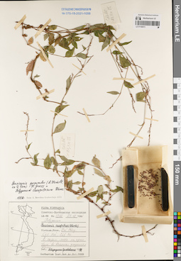
LE 01168503
Antigonon leptopus Hook. & Arn. det. Kudryavtzeva, Ekaterina at 26.09.1990
Collectors: Kudryavtzeva, Ekaterina; Ogureeva G. Field collecting number: Kudryavtzeva 003. Collection date: 26.09.1990. Administrative regions: VN - Tinh Khanh Hoa. Groups of specimens: L. V. Averyanov specimens; L. V. Averyanov herbarium; Соглашение Минобрнауки №075-15-2021-1056Original label text:FLORA OF VIETNAM
Record creation: 2022-06-04, Galina Savich, PhotoScan D2. Processing status: work_status_1Citation: Specimen LE 01168503 // Virtual herbarium of Komarov Botanical Institute RAS — http://re.herbariumle.ru/01168503Polygonaceae
Antigonon leptopus Hook. & Arn.
Khanh Hoa Prov.
26.09.1990, Kudryavtzeva E., Ogureeva G.
Kudryavtzeva 003
LE 01168504
Antigonon leptopus Hook. & Arn. det. Kudryavtzeva, Ekaterina at 26.09.1990
Collectors: Kudryavtzeva, Ekaterina; Ogureeva G. Field collecting number: Kudryavtzeva 003. Collection date: 26.09.1990. Administrative regions: VN - Tinh Khanh Hoa. Groups of specimens: L. V. Averyanov specimens; L. V. Averyanov herbarium; Соглашение Минобрнауки №075-15-2021-1056Original label text:FLORA OF VIETNAM
Record creation: 2022-06-04, Galina Savich, PhotoScan D2. Processing status: work_status_1Citation: Specimen LE 01168504 // Virtual herbarium of Komarov Botanical Institute RAS — http://re.herbariumle.ru/01168504Polygonaceae
Antigonon leptopus Hook. & Arn.
Khanh Hoa Prov.
26.09.1990, Kudryavtzeva E., Ogureeva G.
Kudryavtzeva 003

LE 01168505
Homalocladium platycladum L.H.Bailey det. Kudryavtzeva, Ekaterina at 03.10.1990
Collectors: Kudryavtzeva, Ekaterina; Ogureeva G. Field collecting number: Kudryavtzeva 330. Collection date: 03.10.1990. Administrative regions: VN - Tinh Khanh Hoa. Groups of specimens: L. V. Averyanov specimens; L. V. Averyanov herbarium; Соглашение Минобрнауки №075-15-2021-1056Original label text:FLORA OF VIETNAM
Record creation: 2022-06-04, Galina Savich, PhotoScan D2. Processing status: work_status_1Citation: Specimen LE 01168505 // Virtual herbarium of Komarov Botanical Institute RAS — http://re.herbariumle.ru/01168505Polygonaceae
Homalocladium platycladum L.H.Bailey.
Khanh Hoa Prov.
03.10.1990, Kudryavtzeva E., Ogureeva G.
Kudryavtzeva 330
LE 01168506
Homalocladium platycladum L.H.Bailey det. Grabovskaja-Borodina, Alisa Evgenievna at 02.1992
Collectors: Kudryavtzeva, Ekaterina; Ogureeva G. Field collecting number: Kudryavtzeva 330. Collection date: 03.10.1990. Administrative regions: VN - Tinh Khanh Hoa. Groups of specimens: L. V. Averyanov specimens; L. V. Averyanov herbarium; Соглашение Минобрнауки №075-15-2021-1056Original label text:FLORA OF VIETNAM
Record creation: 2022-06-04, Galina Savich, PhotoScan D2. Processing status: work_status_1Citation: Specimen LE 01168506 // Virtual herbarium of Komarov Botanical Institute RAS — http://re.herbariumle.ru/01168506Polygonaceae
Homalocladium platycladum L.H.Bailey.
Khanh Hoa Prov.
03.10.1990, Kudryavtzeva E., Ogureeva G.
Kudryavtzeva 330
Det. Grabovskaja-Borodina, Alisa Evgenievna at 02.1992
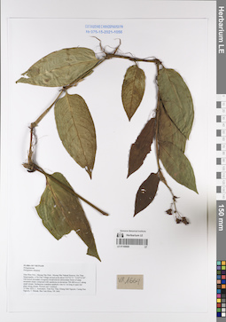
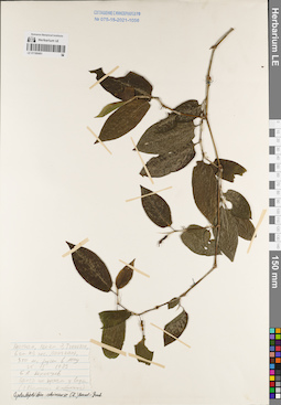
LE 01169669
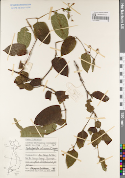
Polygonatum chinense Kunth det. Averyanov, Leonid Vladimirovich at 15.05.2022
Collectors: Averyanov, Leonid Vladimirovich; Tran Huy Thai; Khang Sinh Nguyen; et al. Field collecting number: VR1664. Collection date: 15.05.2022. Administrative regions: VN - Tinh Dien Bien. Groups of specimens: Образцы общего сектора; L. V. Averyanov specimens; L. V. Averyanov herbarium; Соглашение Минобрнауки №075-15-2021-1056Original label text:FLORA OF VIETNAM
Polygonaceae
Polygonum chinense
Dien Bien Prov., Muong Nhe Distr., Muong Nhe Natural Reserve, Sin Thau Municipality, A Pa Chai Village around point about N22º22’51’’ E102º14’26”. Old humid secondary evergreen broad-leaved submontane forest of steep mountain slopes composed with sandstone at elevations 700–800 m a.s.l. along small stream. Herbaceous scandent epiphytic vine to 3 m long in open wet place along stream. Flowers red. Common.
15 May 2022, L. Averyanov, Tran Huy Thai, Khang Sinh Nguyen, Cuong Huu Nguyen, T. Maisak, Bac Cam Khoa, VR 1664.