View
Add
Copy
Edit
Delete
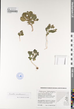
LE 01194200
Polycarpon tetraphyllum (L.) L. det. Byalt, Vyacheslav Vyacheslavovich
Collectors: Byalt, Vyacheslav Vyacheslavovich; Korshunov, Mikhail Vladimirovich Field collecting number: 1137/531. Collection date: 03.04.2018. Administrative regions: AE - United Arab Emirates. Place of collection: Фуджейра, пос. Аль Бидия, сорное вдоль забора сада.Groups of specimens: Образцы общего сектора; Соглашение Минобрнауки №075-15-2021-1056; Бялт В.В.: Флора ФуджейрыOriginal label text: United Arab Emirates. Emirate of Fujaira, village Al Bidiyah, 25°26'13" N, 56°20'2"° Е: weed along fence of garden. – ОАЭ, Фуджейра, посёлок Аль Бидия, 25°26'13" N, 56°20'2"° Е: сорняк вдоль забора сада, 3–4 IV 2018, V.V. Byalt, M.V. Korshunov 1137/531
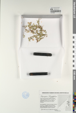
LE 01229140
Cometes surattensis L. det. Byalt, Vyacheslav Vyacheslavovich at 15.12.2022
Additional identifications: Polycarpon tetraphyllum (L.) L. det. Byalt, Vyacheslav Vyacheslavovich Groups of specimens: Образцы общего сектора; Соглашение Минобрнауки №075-15-2021-1056Record creation: 2023-02-24, Denis Melnikov, PhotoScan D2.Citation: Specimen LE 01229140 // Virtual herbarium of Komarov Botanical Institute RAS — http://re.herbariumle.ru/01229140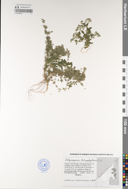
LE 01229155
Polycarpon tetraphyllum (L.) L. det. Byalt, Vyacheslav Vyacheslavovich
Collectors: Byalt, Vyacheslav Vyacheslavovich; Korshunov, Mikhail Vladimirovich Field collecting number: 855. Collection date: 19.03.2020. Administrative regions: AE - United Arab Emirates. Place of collection: Fujairah Emirate, Al Wahlah, wadi Al Hilo Fort (Ohala Fort) [point 334]: in gravel-stony wadi, under rock in shade.Groups of specimens: Образцы общего сектора; Соглашение Минобрнауки №075-15-2021-1056; Бялт В.В.: Флора ФуджейрыOriginal label text: United Arab Emirates, Fujairah Emirate, Al Wahlah, wadi Al Hilo Fort (Ohala Fort). 24°54'29.51"N, 56°18'11.86"E, elevation 75 m. [point 334]: in gravel-stony wadi, under rock in shade, 19 III 2020, fl., V.V. Byalt, M.V. Korshunov 855

LE 01229192
Polycarpon tetraphyllum (L.) L. det. Unknown
Collectors: Byalt, Vyacheslav Vyacheslavovich; Korshunov, Mikhail Vladimirovich Field collecting number: s.n. Collection date: 24.03.2020. Administrative regions: AE - United Arab Emirates. Place of collection: Fujairah emirate, 0.6 km East-North-East to cell tower on the mountain peak, 3.5 km West to Ghub, 8 km West-South-West to Dibba [point 720]: mountain peak; on mountain sides; in stone wadi; on abandoned baghara (winter season dryland farm).Groups of specimens: Образцы общего сектора; Соглашение Минобрнауки №075-15-2021-1056; Бялт В.В.: Флора ФуджейрыOriginal label text: United Arab Emirates, Fujairah emirate, 0.6 km East-North-East to cell tower on the mountain peak, 3.5 km West to Ghub, 8 km West-South-West to Dibba. 25°34'34.49"N, 56°10'6.31"E, elevation 730 m. [point 720]: Mountain peak; on mountain sides; in stone wadi; on abandoned baghara (winter season dryland farm), 24 III 2020, V.V. Byalt, M.V. Korshunov
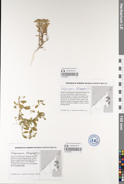
LE 01229193
Polycarpon tetraphyllum (L.) L. det. Byalt, Vyacheslav Vyacheslavovich
Collectors: Byalt, Vyacheslav Vyacheslavovich; Korshunov, Mikhail Vladimirovich Field collecting number: s.n. Collection date: 24.03.2020. Administrative regions: AE - United Arab Emirates. Place of collection: Fujairah emirate, cell tower on the mountain peak, 3.5 km West to Ghub, 8 km West-South-West to Dibba [point 719]: mountain slope.Groups of specimens: Образцы общего сектора; Соглашение Минобрнауки №075-15-2021-1056; Бялт В.В.: Флора ФуджейрыOriginal label text: United Arab Emirates, Fujairah emirate, cell tower on the mountain peak, 3.5 km West to Ghub, 8 km West-South-West to Dibba. 25°34'14.16"N, 56° 9'58.28"E, elevation 765 m. [point 719]: mountain slope, 24 III 2020, V.V. Byalt, M.V. Korshunov