View
Add
Copy
Edit
Delete
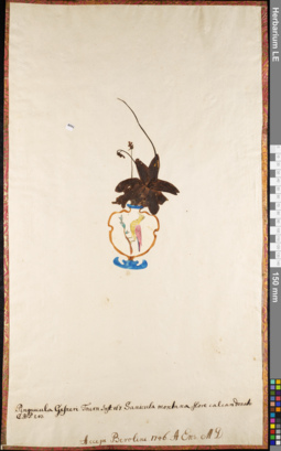
LE 01052314
Pinguicula vulgaris L. ⟮prelim. ID⟯ det. Sytin, Andrej Kirillovich at 25.10.2020
Groups of specimens: Herbarium of Abraham EnsOriginal label text:Pinguicula Gesneri. Toutrn. Inst. 167. Sanicula montana, flore calcari donato. C.B.P. 243. Accepi Berolini. 1746. A. Ens. M.D.
Comment: Pinguicula 103
Record creation: 2020-08-09, Andrey Sytin, PhotoScan D2Citation: Specimen LE 01052314 // Virtual herbarium of Komarov Botanical Institute RAS — http://re.herbariumle.ru/01052314
LE 01101097
Pinguicula alpina L.
Administrative regions: FI - Finland. Groups of specimens: Образцы сектора Восточной ЕвропыRecord creation: 2021-02-13, Flora of the Murmansk region, PhotoScan D2Citation: Specimen LE 01101097 // Virtual herbarium of Komarov Botanical Institute RAS — http://re.herbariumle.ru/01101097
LE 01101398
Pinguicula villosa L.
Administrative regions: FI - Finland. Groups of specimens: Образцы сектора Восточной ЕвропыRecord creation: 2021-03-12, Flora of the Murmansk region, PhotoScan D2Citation: Specimen LE 01101398 // Virtual herbarium of Komarov Botanical Institute RAS — http://re.herbariumle.ru/01101398
LE 01101405
Pinguicula villosa L.
Administrative regions: FI - Finland. Groups of specimens: Образцы сектора Восточной ЕвропыRecord creation: 2021-03-12, Flora of the Murmansk region, PhotoScan D2Citation: Specimen LE 01101405 // Virtual herbarium of Komarov Botanical Institute RAS — http://re.herbariumle.ru/01101405
LE 01101406
Pinguicula villosa L.
Administrative regions: FI - Finland. Groups of specimens: Образцы сектора Восточной ЕвропыRecord creation: 2021-03-12, Flora of the Murmansk region, PhotoScan D2Citation: Specimen LE 01101406 // Virtual herbarium of Komarov Botanical Institute RAS — http://re.herbariumle.ru/01101406
LE 01101407
Pinguicula villosa L.
Administrative regions: SE - Sweden. Groups of specimens: Образцы сектора Восточной ЕвропыRecord creation: 2021-03-12, Flora of the Murmansk region, PhotoScan D2Citation: Specimen LE 01101407 // Virtual herbarium of Komarov Botanical Institute RAS — http://re.herbariumle.ru/01101407
LE 01101408
Pinguicula villosa L.
Collectors: Schrenk, Alexandr Gustav von Administrative regions: FI - Finland. Groups of specimens: Образцы сектора Восточной ЕвропыRecord creation: 2021-03-12, Flora of the Murmansk region, PhotoScan D2Citation: Specimen LE 01101408 // Virtual herbarium of Komarov Botanical Institute RAS — http://re.herbariumle.ru/01101408
LE 01108436
Pinguicula vulgaris L. det. Ivchenko, Tat'yana Georgievna at 16.07.2020
Collectors: Ivchenko, Tat'yana Georgievna Collection date: 16.07.2020. Administrative regions: RU - Bashkortostan - Uchalinskiy Rayon. Топоним: природный парк "Иремель". Groups of specimens: Образцы сектора Восточной Европы; Соглашение Минобрнауки №075-15-2021-1056Original label text:Россия, Республика Башкортостан, Учалинский район, ПП "Иремель", массив, входящий в систему "Карагужинское болото" вдоль левого берега реки Белой в окрестностях деревни Байсакалово, 54°28'00.8''N - 58°58'46.1''E, высота - 625 м над уровнем моря, осоково-гипновое сообщество богатого грунтового питания, занимающее пониженные участки микрорельефа в олиготрофном кочковато-мочажинном комплексе, единично.
Coordinates (geographic position): 54° 28′ 2.37″ N, 58° 58′ 41.29″ E ±100 mRecord creation: 2022-11-10, Denis Melnikov, PhotoScan D2.Citation: Specimen LE 01108436 // Virtual herbarium of Komarov Botanical Institute RAS — http://re.herbariumle.ru/01108436
LE 01138497
Pinguicula vulgaris L. det. Puring, Nicolai Ivanovich at 05.1898
Collectors: Dzejver Artur Collection date: 05.1898. Administrative regions: RU - Pskovskaya Oblast' - Palkinskiy Rayon. Subregion: Качановская волость.. Groups of specimens: Образцы сектора Восточной Европы; Соглашение Минобрнауки №075-15-2021-1056; Гербарий Юрьевского ботанического садаOriginal label text:Псковская Флора
Coordinates (geographic position): 57° 28′ 26.8″ N, 27° 46′ 33.66″ E ±1500 mRecord creation: 2022-11-10, Denis Melnikov, PhotoScan D2.Citation: Specimen LE 01138497 // Virtual herbarium of Komarov Botanical Institute RAS — http://re.herbariumle.ru/01138497Окрестности села Покровского Качан[овская] волость
Торфянистые луга, по кочкам.