View
Add
Copy
Edit
Delete
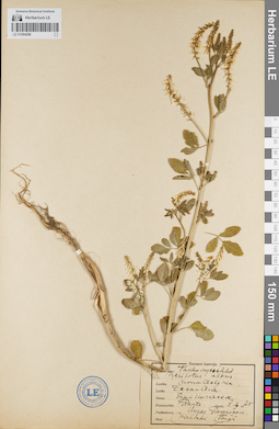
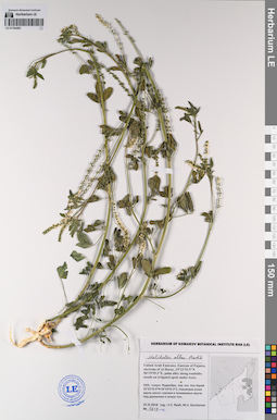
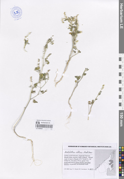
LE 01094286
Melilotus albus Medikus
Administrative regions: FI - Finland. Groups of specimens: Образцы сектора Восточной Европы; Соглашение Минобрнауки №075-15-2021-1056Record creation: 2021-11-24, Flora of the Murmansk region, PhotoScan D2Citation: Specimen LE 01094286 // Virtual herbarium of Komarov Botanical Institute RAS — http://re.herbariumle.ru/01094286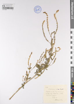
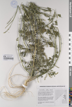
LE 01176910
Melilotus albus Medikus det. Vasilevich, Vladislav Ivanovich at 20.07.1977
Collectors: Vasilevich, Vladislav Ivanovich Field collecting number: 539. Collection date: 20.07.1977. Administrative regions: RU - Pskovskaya Oblast'. Groups of specimens: Образцы сектора Восточной Европы; Соглашение Минобрнауки №075-15-2021-1056Original label text:539
Melilotus albus Medik
Псковская обл. Пороховский р-н, между дер. Студенец и Павы обочина дороги
20,VII.1977
LE 01193780
Melilotus albus Medikus det. Byalt, Vyacheslav Vyacheslavovich
Collectors: Byalt, Vyacheslav Vyacheslavovich; Korshunov, Mikhail Vladimirovich Field collecting number: 2138. Collection date: 14.04.2020. Administrative regions: AE - United Arab Emirates. Place of collection: Fujairah Emirate, Bidya, villas and sideroads opposite to Al Bidiya market [point 752]: in gravel-sand wadi.Groups of specimens: Образцы общего сектора; Соглашение Минобрнауки №075-15-2021-1056; Бялт В.В.: Флора ФуджейрыOriginal label text: United Arab Emirates, Fujairah Emirate, Bidya, villas and sideroads opposite to Al Bidiya market. 25°25'57.34"N, 56°21'6.57"E, elevation 10 m. [point 752]: in gravel-sand wadi, on gravel, 14 IV 2020, fl., fr.,V.V. Byalt, M.V. Korshunov 2138
LE 01193832
Melilotus albus Medikus det. Byalt, Vyacheslav Vyacheslavovich
Collectors: Byalt, Vyacheslav Vyacheslavovich; Korshunov, Mikhail Vladimirovich Field collecting number: 2091. Collection date: 14.04.2020. Administrative regions: AE - United Arab Emirates. Place of collection: Sharjah Emirate, Luluyah, end of Safi Esa Al Naqbi st. and gardens near Luluyah Beach [point 753]: weed in the garden.Groups of specimens: Образцы общего сектора; Соглашение Минобрнауки №075-15-2021-1056; Бялт В.В.: Флора ФуджейрыOriginal label text: United Arab Emirates, Sharjah Emirate, Luluyah, end of Safi Esa Al Naqbi st. and gardens near Luluyah Beach. 25°23'24.43"N, 56°21'40.92"E, elevation 5 m. [point 753]: weed in the garden, 14 IV 2020, fl., fr., V.V. Byalt, M.V. Korshunov 2091
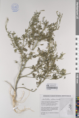
LE 01194483
Melilotus albus Medikus det. Byalt, Vyacheslav Vyacheslavovich
Collectors: Byalt, Vyacheslav Vyacheslavovich; Korshunov, Mikhail Vladimirovich Field collecting number: 1318a. Collection date: 25.03.2018. Administrative regions: AE - United Arab Emirates. Place of collection: эмират Фуджейра, окрестности пос. Аль Харай, пальмовая аллея вдоль шоссе: сорняки в поливаемых кругах под деревьями и вокруг них.Groups of specimens: Образцы общего сектора; Соглашение Минобрнауки №075-15-2021-1056; Бялт В.В.: Флора ФуджейрыOriginal label text: United Arab Emirates. Emirate of Fujaira, environs of Al Haray, 25°23'53.9"N 56°19'55.3"E, palm alley along roadside: weeds on irrigated spots under trees. – ОАЭ, эмират Фуджейра, окр. пос. Аль Харай, 25°23'53.9"N 56°19'55.3"E, пальмовая аллея вдоль шоссе: сорняки в поливаемых кругах под деревьями и вокруг них, 25 III 2018, fl., fr., V.V. Byalt, M.V. Korshunov 1318a
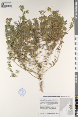
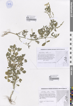
LE 01259134
Melilotus albus Medikus det. Byalt, Vyacheslav Vyacheslavovich
Collectors: Byalt, Vyacheslav Vyacheslavovich; Korshunov, Mikhail Vladimirovich Field collecting number: 1318. Collection date: 25.03.2018. Administrative regions: AE - United Arab Emirates. Place of collection: эмират Фуджейра, окрестности пос. Аль Харай, пальмовая аллея вдоль шоссе: сорное в поливаемых кругах под деревьями и вокруг них.Groups of specimens: Образцы общего сектора; Соглашение Минобрнауки №075-15-2021-1056; Бялт В.В.: Флора ФуджейрыOriginal label text: United Arab Emirates. Emirate of Fujaira, environs of Al Haray, 25°23'53.9"N 56°19'55.3"E, palm alley along roadside: weeds on irrigated spots under trees. – ОАЭ, эмират Фуджейра, окр. пос. Аль Харай, 25°23'53.9"N 56°19'55.3"E, пальмовая аллея вдоль шоссе: сорняки в поливаемых кругах под деревьями и вокруг них, 25 III 2018, fl., fr., V.V. Byalt, M.V. Korshunov 1318
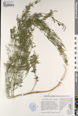
LE 01259136
Melilotus albus Medikus det. Byalt, Vyacheslav Vyacheslavovich
Collectors: Byalt, Vyacheslav Vyacheslavovich; Korshunov, Mikhail Vladimirovich Field collecting number: 1319. Collection date: 25.03.2018. Administrative regions: AE - United Arab Emirates. Place of collection: эмират Фуджейра, окрестности пос. Аль Харай, пальмовая аллея вдоль шоссе: сорное в поливаемых кругах под деревьями и вокруг них.Groups of specimens: Образцы общего сектора; Соглашение Минобрнауки №075-15-2021-1056; Бялт В.В.: Флора ФуджейрыOriginal label text: United Arab Emirates. Emirate of Fujaira, environs of Al Haray, 25°23'53.9"N 56°19'55.3"E, palm alley along roadside: weeds on irrigated spots under trees. – ОАЭ, эмират Фуджейра, окр. пос. Аль Харай, 25°23'53.9"N 56°19'55.3"E, пальмовая аллея вдоль шоссе: сорняки в поливаемых кругах под деревьями и вокруг них, 25 III 2018, fl., fr., V.V. Byalt, M.V. Korshunov 1319
LE 01259688
Melilotus albus L. det. Byalt, Vyacheslav Vyacheslavovich
Collectors: Byalt, Vyacheslav Vyacheslavovich; Korshunov, Mikhail Vladimirovich Field collecting number: 1567. Collection date: 01.04.2020. Administrative regions: AE - United Arab Emirates. Place of collection: Fujairah Emirate, Al Siji, Al Siji dump wasting area [point 727]: agricultural and household trash in wadi.Groups of specimens: Образцы общего сектора; Соглашение Минобрнауки №075-15-2021-1056; Бялт В.В.: Флора ФуджейрыOriginal label text: United Arab Emirates, Fujairah Emirate, Al Siji, Al Siji dump wasting area. 25°16'7.17"N, 56° 0'37.91"E, elevation 200 m. [point 727]: agricultural and houshold trash in wadi, fl. white, 1 IV 2020, V.V. Byalt, M.V. Korshunov 1567

LE 01259689
Melilotus albus Medikus det. Byalt, Vyacheslav Vyacheslavovich
Collectors: Byalt, Vyacheslav Vyacheslavovich; Korshunov, Mikhail Vladimirovich Field collecting number: 211. Collection date: 11.03.2020. Administrative regions: AE - United Arab Emirates. Place of collection: Fujairah Emirate, Al Hayl Fort (Al Hayl Castle) [point 704]: wadi bottom.Groups of specimens: Образцы общего сектора; Соглашение Минобрнауки №075-15-2021-1056; Бялт В.В.: Флора ФуджейрыOriginal label text: United Arab Emirates, Fujairah Emirate, Al Hayl Fort (Al Hayl Castle). 25° 5'4.59"N, 56°13'36.84"E, elevation 240–310 m [point 704]: wadi bottom, 11 III 2020, V.V. Byalt, M.V. Korshunov 211
LE 01259828
Melilotus albus Medikus det. Byalt, Vyacheslav Vyacheslavovich
Collectors: Byalt, Vyacheslav Vyacheslavovich; Korshunov, Mikhail Vladimirovich Field collecting number: 1683-1. Collection date: 03.04.2020. Administrative regions: AE - United Arab Emirates. Place of collection: Fujairah Emirate, Masafi friday market, E88 Al Dhaid – Masafi road, 5.2 km to Masafi [point 732]: weed in plant market and nursery.Groups of specimens: Образцы общего сектора; Соглашение Минобрнауки №075-15-2021-1056; Бялт В.В.: Флора ФуджейрыOriginal label text: UAE, Fujairah Emirate, Masafi friday market, E88 Al Dhaid – Masafi road, 5.2 km to Masafi. 25°17'28.28"N, 56° 6'48.62"E, elevation 370 m [point 732]: weed in plant market and nursery, 3 IV 2020, fl., fr., V.V. Byalt, M.V. Korshunov 1683-1