View
Add
Copy
Edit
Delete
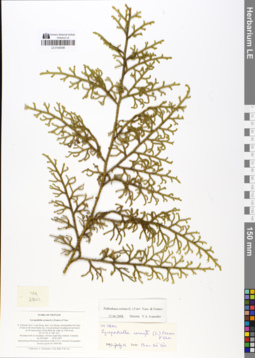
LE 01048398
Lycopodiella cernua (L.) Pic. Serm. det. Phan Ke Loc at 19.07.1997
Additional identifications: Lycopodium cernuum L. det. Averyanov, Leonid Vladimirovich at 2013; Palhinhaea cernua (L.) Franco & Vasc. det. Ivanenko, Yuri Alekseevich at 23.06.2008 Collectors: Averyanov, Leonid Vladimirovich; et al. Field collecting number: VH2801. Collection date: 18.03.1997. Administrative regions: VN - Tinh Lam GJong. Groups of specimens: L. V. Averyanov specimens; L. V. Averyanov herbariumOriginal label text:FLORA OF VIETNAM. Lycopodiella cernua (L.) Franco et Vasc. S. Vietnam, Prov. Lam Dong, distr. Lac Duong, municipalite Da Chay,. 35 km to NE from Dalat city. Closed primary broadleaved mt forest. on W macroslope of Gia Rich mt. ridge at 1700 m alt. . (N 12° 09', E 108° 41'). Prostrate herb in wet places. Flowers light lilac-whitish. Common. No VH 2801 18.03.1997. International Botanical Expedition of the U.S.A. National Geographic. Society (grant No 5803-96). . Collectors: L. Averyanov, N.Q. Binh, P.K. Loc
Coordinates (geographic position): 12° 9′ N, 108° 41′ E ±1000 mRecord creation: 2019-02-22, Leonid Averyanov, PhotoScan D1Citation: Specimen LE 01048398 // Virtual herbarium of Komarov Botanical Institute RAS — http://re.herbariumle.ru/01048398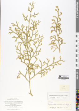
LE 01048487
Lycopodium cernuum L. det. Averyanov, Leonid Vladimirovich at 2013
Additional identifications: Lycopodiella cernua (L.) Pic. Serm. det. Phan Ke Loc at 19.07.1997; Palhinhaea cernua (L.) Franco & Vasc. det. Ivanenko, Yuri Alekseevich at 23.06.2008 Collectors: Averyanov, Leonid Vladimirovich; et al. Field collecting number: VH3390. Collection date: 30.03.1997. Administrative regions: VN - Tinh Lam GJong. Groups of specimens: L. V. Averyanov specimens; L. V. Averyanov herbariumOriginal label text:FLORA OF VIETNAM. Lycopodiella cernua (L.) Franco et Vasc. S. Vietnam, Prov. Lam Dong, distr. Lac Duong, municipalite Da Chay,. 32.5 km to NE from Dalat city. Closed primary broadleaved mt forest. along very wet deep stream canyon on NNW macroslope of Bi Dup mt. system in 6-7 km to NNW from main peak at 1600-1700 m alt. . (N 12° 07', E 108° 41'). Terrestrial herb up to 1 m hg. Common on open steep slopes. No VH 3390 30.03.1997. International Botanical Expedition of the U.S.A. National Geographic. Society (grant No 5803-96). . Collectors: L. Averyanov, N.Q. Binh, P.K. Loc
Coordinates (geographic position): 12° 7′ N, 108° 41′ E ±1000 mRecord creation: 2019-02-22, Leonid Averyanov, PhotoScan D1Citation: Specimen LE 01048487 // Virtual herbarium of Komarov Botanical Institute RAS — http://re.herbariumle.ru/01048487
LE 01172648
Lycopodiella inundata (L.) Holub det. Unknown at 29.06.2021
Collectors: Konechnaya, Galina Yurievna; Efimov, Peter Gennadievich; Sheludyakova, Mariya Borissovna Collection date: 29.06.2021. Administrative regions: RU - Respublika Kareliya - Belomorskiy Rayon. Groups of specimens: Образцы сектора Восточной Европы; Соглашение Минобрнауки №075-15-2021-1056Original label text:Республика Карелия, Беломорский район, западнее шоссе Кола у пересечения с рекой Идель, на сыром песчаном грунте в старом карьере
Record creation: 2023-08-15, Artyom Borodushkin, PhotoScan D2. Part 2.Citation: Specimen LE 01172648 // Virtual herbarium of Komarov Botanical Institute RAS — http://re.herbariumle.ru/01172648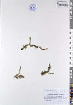
LE 01246215
Lycopodiella inundata (L.) Holub det. Unknown at 08.08.2020
Collectors: Efimov, Peter Gennadievich Field collecting number: Нет. Collection date: 08.08.2020. Administrative regions: RU - Novgorodskaya Oblast' - Lyubytinskiy Rayon. Groups of specimens: Образцы сектора Восточной Европы; Соглашение Минобрнауки №075-15-2021-1056Original label text:Новгородская область, Любытинский район окрестности деревни Теребутенец, на трассе нефтепровода, сырой открытый участок (N: 59,0211833°; E: 33,6694683°)
Coordinates (geographic position): 59° 1′ 16.26″ N, 33° 40′ 10.09″ ERecord creation: 2023-08-15, Artyom Borodushkin, PhotoScan D2. Part 2.Citation: Specimen LE 01246215 // Virtual herbarium of Komarov Botanical Institute RAS — http://re.herbariumle.ru/01246215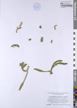
LE 01246218
Lycopodiella inundata (L.) Holub det. Unknown at 14.08.2019
Collectors: Konechnaya, Galina Yurievna; Kuropatkin Vladislav Field collecting number: Нет. Collection date: 14.08.2019. Administrative regions: RU - Novgorodskaya Oblast' - Borovichskiy Rayon. Groups of specimens: Образцы сектора Восточной Европы; Соглашение Минобрнауки №075-15-2021-1056Original label text:Новгородская область, Боровичский район, правый берег реки Мсты, между деревней Жадины и деревней Большой Чернец, линия ЛЭП в сосняке, влажная низина (N: 58°15'05"; E: 34°15'04")
Coordinates (geographic position): 58° 15′ 5″ N, 34° 15′ 4″ ERecord creation: 2023-08-15, Artyom Borodushkin, PhotoScan D2. Part 2.Citation: Specimen LE 01246218 // Virtual herbarium of Komarov Botanical Institute RAS — http://re.herbariumle.ru/01246218