View
Add
Copy
Edit
Delete
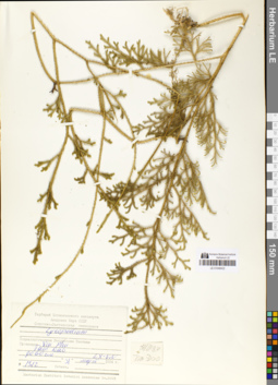
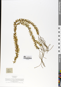
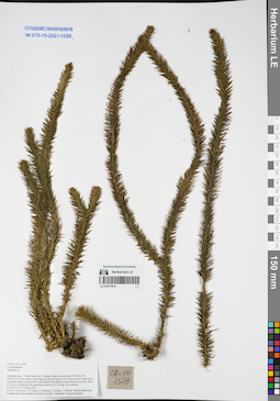
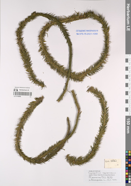
LE 01048422
Lycopodium cernuum L. det. Averyanov, Leonid Vladimirovich at 2013
Collectors: Averyanov, Leonid Vladimirovich; et al. Field collecting number: LX-VN 1312. Collection date: 31.03.1984. Administrative regions: VN - Tinh Vinh Phuc. Groups of specimens: L. V. Averyanov specimens; L. V. Averyanov herbariumOriginal label text:FLORA VIETNAMICA
Soviet – Vietnamese Expedition
LX-VN 1312
31.03.1984
Lycopodiaceae
Lycopodium cernuum L.
Vietnam. Prov. Tam Dao
Det.: L. Averyanov 2013
Soviet – Vietnamese Expedition
LX-VN 1312
31.03.1984
Lycopodiaceae
Lycopodium cernuum L.
Vietnam. Prov. Tam Dao
Det.: L. Averyanov 2013
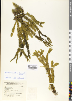
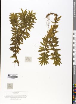
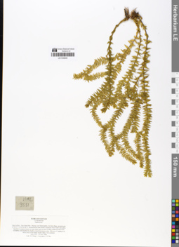
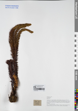
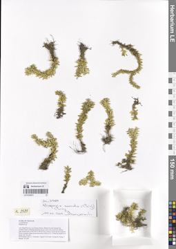
LE 01048423
Huperzia hamiltonii (Spreng.) Trevis. det. Ivanenko, Yuri Alekseevich at 29.07.2008
Additional identifications: Lycopodium hamiltonii Spreng. det. Averyanov, Leonid Vladimirovich at 2013 Collectors: Averyanov, Leonid Vladimirovich; et al. Field collecting number: LX-VN 2392. Collection date: 13.06.1985. Administrative regions: VN - Tinh Vinh Phuc. Groups of specimens: L. V. Averyanov specimens; L. V. Averyanov herbariumOriginal label text:FLORA VIETNAMICA
Soviet – Vietnamese Expedition
LX-VN 2392
13.06.1985
Lycopodiaceae
Soviet – Vietnamese Expedition
LX-VN 2392
13.06.1985
Lycopodiaceae
Huperzia hamiltonii (Spreng.) Trevis.
Vietnam. Prov.Vinh Phuc, Tam Dao', h~900 m a.s.l.
Vietnam. Prov.Vinh Phuc, Tam Dao', h~900 m a.s.l.
Det.: L. Averyanov 2013
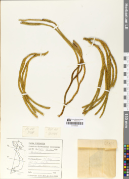
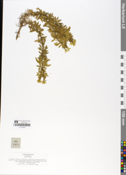
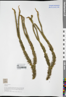
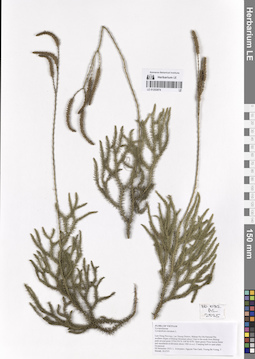
LE 01048424
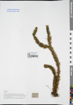
Huperzia carinata (Poir.) Trevis. det. Averyanov, Leonid Vladimirovich at 28.12.1986
Collectors: Averyanov, Leonid Vladimirovich; et al. Field collecting number: LX-VN 3484. Collection date: 28.12.1986. Administrative regions: VN - Thanh Pho Hai Phong. Groups of specimens: L. V. Averyanov specimens; L. V. Averyanov herbariumOriginal label text:FLORA VIETNAMICA
Soviet – Vietnamese Expedition
LX-VN 3484
28.12.1986
Lycopodiaceae
Huperzia carinata (Desv. ex Poir.) Trevis.
Vietnam. Prov. Hai Phong, Cat Hai, Cat Ba
Soviet – Vietnamese Expedition
LX-VN 3484
28.12.1986
Lycopodiaceae
Huperzia carinata (Desv. ex Poir.) Trevis.
Vietnam. Prov. Hai Phong, Cat Hai, Cat Ba
Det.: L. Averyanov 28.12.1986
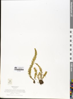
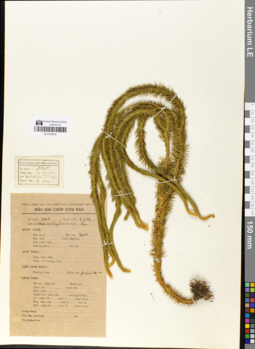
LE 01048428
Huperzia phlegmaria (L.) Rothm. det. Averyanov, Leonid Vladimirovich at 2013
Additional identifications: Lycopodium phlegmaria L. det. Averyanov, Leonid Vladimirovich at 2013 Collectors: Averyanov, Leonid Vladimirovich; et al. Field collecting number: HAL2324. Collection date: 14.03.2002. Administrative regions: VN - Tinh Lao Cai. Groups of specimens: L. V. Averyanov specimens; L. V. Averyanov herbariumOriginal label text:FLORA OF VIETNAM. Fam. Lycopodiaceae. Huperzia sp. Northern Vietnam, Lao Cai Prov., Van Ban Distr., Khanh Yen Ha. municipality, elevation from Na Nheo village to the S from 680 to 880. m a.s.l. (around point 21°58'28"N, 104°15'52"E). Primary evergreen. broad-leaved submontane forest on steep granite and quartzite slopes at. elev. 800-880 m a.s.l. Epiphyte on mossy trees. Common. No HAL 2324 14 March 2002. . Collectors: L.Averyanov, P.K.Loc, D.T.Doan (FFI Project).
Coordinates (geographic position): 21° 58′ 28″ N, 104° 15′ 52″ E ±1000 mRecord creation: 2019-02-22, Leonid Averyanov, PhotoScan D1Citation: Specimen LE 01048428 // Virtual herbarium of Komarov Botanical Institute RAS — http://re.herbariumle.ru/01048428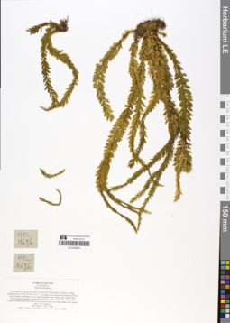
LE 01048434
Huperzia phlegmaria (L.) Rothm. det. Averyanov, Leonid Vladimirovich at 12.12.2006
Collectors: Tien Hiep Nguyen; Averyanov, Leonid Vladimirovich; Phan Ke Loc; The Van Pham; N.T.Vinh Field collecting number: HAL10696. Collection date: 13.12.2006. Administrative regions: VN - Tinh Lai Chau. Groups of specimens: L. V. Averyanov specimens; L. V. Averyanov herbarium; L. V. Averyanov photosOriginal label text:FLORA OF VIETNAM
Record creation: 2019-02-22, Leonid Averyanov, PhotoScan D1Citation: Specimen LE 01048434 // Virtual herbarium of Komarov Botanical Institute RAS — http://re.herbariumle.ru/01048434Lycopodiaceae
LE 01048435
Huperzia serrata (Thunb.) Trevis. det. Averyanov, Leonid Vladimirovich at 29.11.2006
Collectors: Averyanov, Leonid Vladimirovich; et al. Field collecting number: HAL10192. Collection date: 29.11.2006. Administrative regions: VN - Tinh Lai Chau. Groups of specimens: L. V. Averyanov specimens; L. V. Averyanov herbarium; L. V. Averyanov photosOriginal label text:FLORA OF VIETNAM. Lycopodiaceae. Huperzia serrata. Lai Chau Prov., Tam Duong Distr., Ho Thau Community, Ho Thau village, around point 22°23'05"N 103°36'46"E. Secondary and primary evergreen closed forest on very steep mountain slopes composed with granite and quartzite at elevation from 1500 to 1900 m a.s.l. Terrestrial and lithophytic herb along mossy ridge edge. Locally common. HAL 10192 29 Nov. 2006 Photo. Coll.: Nguyen Tien Hiep, L.Averyanov, Pham Van The.
Coordinates (geographic position): 22° 23′ 5″ N, 103° 36′ 46″ E ±1000 mRecord creation: 2019-02-22, Leonid Averyanov, PhotoScan D1Citation: Specimen LE 01048435 // Virtual herbarium of Komarov Botanical Institute RAS — http://re.herbariumle.ru/01048435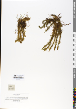
LE 01048436
Huperzia chinensis (H. Christ) Czerep. det. Averyanov, Leonid Vladimirovich at 2013
Collectors: Tien Hiep Nguyen; Averyanov, Leonid Vladimirovich; The Van Pham Field collecting number: HAL10484. Collection date: 07.12.2006. Administrative regions: VN - Tinh Lai Chau. Groups of specimens: L. V. Averyanov specimens; L. V. Averyanov herbarium; Flora of VietnamOriginal label text:FLORA OF VIETNAM
Coordinates (geographic position): 22° 24′ 19″ N, 103° 36′ 42″ E ±1000 mRecord creation: 2019-02-22, Leonid Averyanov, PhotoScan D1. Processing status: work_status_1Citation: Specimen LE 01048436 // Virtual herbarium of Komarov Botanical Institute RAS — http://re.herbariumle.ru/01048436Lycopodiaceae
Huperzia sp.
Lai Chau Prov., Tam Duong Distr., Ho Thau Community, Ho Thau village, around point 22°24'19"N 103°36'42"E. Primary closed evergreen broad-leaved wet cloudy ericaceous forest on very steep mountain slopes and on tops of ridge composed predominantly with shale at elev. about 2300-2500 m a.s.l. Epiphyte on mossy trees along tops of ridge. Rare. HAL 10484 7 Dec. 2006. Coll.: Nguyen Tien Hiep, L.Averyanov, Pham Van The.
LE 01048437
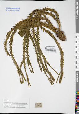
Lycopodium squarrosum G. Forst. det. Averyanov, Leonid Vladimirovich at 2013
Collectors: Unknown Field collecting number: 7165. Collection date: 09.07.1962. Administrative regions: VN - Tinh Ha Giang. Groups of specimens: L. V. Averyanov specimens; L. V. Averyanov herbariumOriginal label text:FLORA OF VIETNAM
Record creation: 2019-02-22, Leonid Averyanov, PhotoScan D1Citation: Specimen LE 01048437 // Virtual herbarium of Komarov Botanical Institute RAS — http://re.herbariumle.ru/01048437Lycopodiaceae
LE 01048438
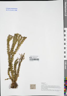
Huperzia salvinioides (Herter) Holub det. Averyanov, Leonid Vladimirovich at 04.04.2007
Collectors: Averyanov, Leonid Vladimirovich; et al. Field collecting number: HAL10864. Collection date: 04.04.2007. Administrative regions: VN - Tinh Thua Thien-Hue. Groups of specimens: L. V. Averyanov specimens; L. V. Averyanov herbarium; Соглашение Минобрнауки №075-15-2021-1056; Flora of VietnamOriginal label text:FLORA OF VIETNAM.
Coordinates (geographic position): 16° 7′ 35″ N, 107° 44′ 53″ E ±1000 mRecord creation: 2019-02-22, Leonid Averyanov, PhotoScan D1. Processing status: work_status_1Citation: Specimen LE 01048438 // Virtual herbarium of Komarov Botanical Institute RAS — http://re.herbariumle.ru/01048438 Lycopodiaceae.
Huperzia phlegmaria.
Thua Thien ° Hue Prov., Nam Dong Distr., Thuong Lo Municipality, along Cha Mang stream, around point 16°07'35"N 107°44'53"E. Remnants of primary evergreen broad-leaved lowland forest on very steep hill slopes composed with stratified shale and sandstone at elev. about 150 m a.s.l. Epiphyte on mossy trees on very steep shady rocky slope along shady stream. Occasional. HAL 10864 4 Apr. 2007. Coll.: L.Averyanov, Phan Ke Loc, A.Averyanova, N.T.Vinh, N.D.Phuong, L.V.Hung.
LE 01048439
Huperzia serrata (Thunb.) Trevis. det. Averyanov, Leonid Vladimirovich at 17.06.2006
Collectors: Phan Ke Loc; Vinh Tien Nguyen; Khang Sinh Nguyen Field collecting number: HAL8853. Collection date: 06.2006. Administrative regions: VN - Tinh Lao Cai. Groups of specimens: L. V. Averyanov specimens; L. V. Averyanov herbarium; Соглашение Минобрнауки №075-15-2021-1056; Flora of VietnamOriginal label text:FLORA OF VIETNAM.
Record creation: 2019-02-22, Leonid Averyanov, PhotoScan D1. Processing status: work_status_1Citation: Specimen LE 01048439 // Virtual herbarium of Komarov Botanical Institute RAS — http://re.herbariumle.ru/01048439 Lycopodiaceae
Huperzzia serrata.
Lao Cai Prov., Sa Pa Distr., Ta Phin Mun., Tseng Seng vill., around point 22?23'35'' N, 103?50'55'' E, 1308 m. Shaly mountains. Scattered in secondary closed evergreen broad-leaved submontane and montane forests on stream banks. HAL 8853 17 Jun 2006 Photos. Collectors: P.K. Loc, N.T. Vinh and N.S. Khang.
LE 01048440
Huperzia sp. det. Averyanov, Leonid Vladimirovich at 05.11.2006
Collectors: Tien Hiep Nguyen; Averyanov, Leonid Vladimirovich; Phan Ke Loc Field collecting number: HAL9531. Collection date: 05.11.2006. Administrative regions: VN - Tinh Son La. Groups of specimens: L. V. Averyanov specimens; L. V. Averyanov herbarium; Соглашение Минобрнауки №075-15-2021-1056; Flora of VietnamOriginal label text:FLORA OF VIETNAM.
Coordinates (geographic position): 21° 0′ 37″ N, 104° 30′ 6″ E ±1000 mRecord creation: 2019-02-22, Leonid Averyanov, PhotoScan D1. Processing status: work_status_1Citation: Specimen LE 01048440 // Virtual herbarium of Komarov Botanical Institute RAS — http://re.herbariumle.ru/01048440Lycopodiaceae.
Huperzia sp.
Son La Prov., Yen Chau Distr., Muong Lum Municipality, Na Hat village, around point 21°00'37"N 104°30'06"E. Broad-leaved (and former coniferous forest with Calocedrus rupestris) evergreen forest on steep slopes and on tops of ridge composed with rocky crystalline solid marble-like highly eroded limestone at elev. 900 m a.s.l. Epiphyte on mossy tree in wet shady stream valley. Not common. HAL 9531 05 Nov. 2006. Coll.: Nguyen Tien Hiep, L.Averyanov, Pham Van The.
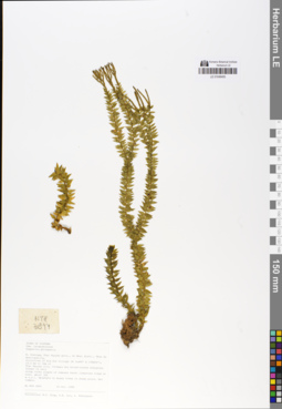
LE 01048442
Huperzia serrata (Thunb.) Trevis. det. Phan Ke Loc at 19.07.1997
Collectors: Averyanov, Leonid Vladimirovich; N.Q. Binh; Phan Ke Loc Field collecting number: VH3031. Collection date: 22.03.1997. Administrative regions: VN - Tinh Lam GJong. Groups of specimens: L. V. Averyanov specimens; L. V. Averyanov herbarium; Соглашение Минобрнауки №075-15-2021-1056; Flora of VietnamOriginal label text:FLORA OF VIETNAM.
Coordinates (geographic position): 12° 6′ N, 108° 39′ E ±1000 mRecord creation: 2019-02-22, Leonid Averyanov, PhotoScan D1. Processing status: work_status_1Citation: Specimen LE 01048442 // Virtual herbarium of Komarov Botanical Institute RAS — http://re.herbariumle.ru/01048442Lycopodiaceae
Huperzia serrata (Thunb.) Trevis.
S. Vietnam, Prov. Lam Dong, 29 km to NE from Dalat city, distr. Lac Duong, municipalite Da Chay. Primary wet closed broadleaved cloud forest along main Bi Dup ridge at 2100-2200 m alt. (N 12° 06', E 108° 39'). Terrestrial herb on steep shadow slopes. Not common. No VH 3031 22.03.1997. International Botanical Expedition of the U.S.A. National Geographic. Society (grant No 5803-96). Collectors: L. Averyanov, N.Q. Binh, P.K. Loc.
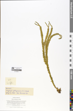
LE 01048443
Huperzia phlegmaria (L.) Rothm. det. Phan Ke Loc at 21.07.1997
Collectors: Averyanov, Leonid Vladimirovich; N.Q. Binh; Tien Hiep Nguyen Field collecting number: VH4272. Collection date: 24.04.1997. Administrative regions: VN - Tinh Khanh Hoa. Groups of specimens: L. V. Averyanov specimens; L. V. Averyanov herbarium; Соглашение Минобрнауки №075-15-2021-1056; Flora of VietnamOriginal label text:FLORA OF VIETNAM.
Coordinates (geographic position): 12° 12′ N, 108° 44′ E ±1000 mRecord creation: 2019-02-22, Leonid Averyanov, PhotoScan D1. Processing status: work_status_1Citation: Specimen LE 01048443 // Virtual herbarium of Komarov Botanical Institute RAS — http://re.herbariumle.ru/01048443Lycopodiaceae
Huperzia phlegmaria (L.) Roth.
S. Vietnam, Prov. Khanh Hoa, distr. Khanh Son, 42 km to NE from Dalat. city. Primary closed broadleaved evergreen forest on E macroslope. of Hon Giao mt. ridge at 1500-1600 m alt. (N 12° 12', E 108° 44'). Epiphytic and epilitic pendant herb on steep rocky slopes. Not rare. No VH 4272 24.04.1997. International Botanical Expedition of the U.S.A. National Geographic. Society (grant No 5803-96). Collectors: L. Averyanov, N.Q. Binh, N.T. Hiep
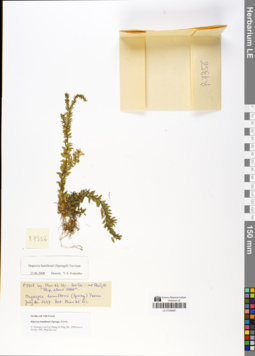
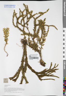
LE 01048491
Huperzia hamiltonii (Spreng.) Trevis. det. Phan Ke Loc at 20.07.1997
Additional identifications: Lycopodium hamiltonii Spreng. det. Averyanov, Leonid Vladimirovich at 2013; Huperzia hamiltonii (Spreng.) Trevis. det. Ivanenko, Yuri Alekseevich at 23.06.2008 Collectors: Phan Ke Loc Field collecting number: P 7356. Collection date: 20.07.1997. Administrative regions: VN - Tinh Lao Cai. Groups of specimens: L. V. Averyanov specimens; L. V. Averyanov herbariumOriginal label text:FLORA OF VIETNAM
Record creation: 2019-02-22, Leonid Averyanov, PhotoScan D1Citation: Specimen LE 01048491 // Virtual herbarium of Komarov Botanical Institute RAS — http://re.herbariumle.ru/01048491Lycopodiaceae
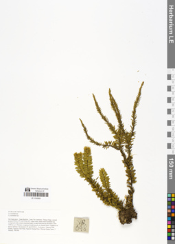
LE 01048493
Huperzia salvinioides (Herter) Holub det. Averyanov, Leonid Vladimirovich at 24.10.1999
Collectors: Tien Hiep Nguyen; Phan Ke Loc; Averyanov, Leonid Vladimirovich Field collecting number: NTH3844. Collection date: 24.10.1999. Administrative regions: VN - Tinh Thai Nguyen. Groups of specimens: L. V. Averyanov specimens; L. V. Averyanov herbarium; Соглашение Минобрнауки №075-15-2021-1056; Flora of VietnamOriginal label text:FLORA OF VIETNAM
Coordinates (geographic position): 21° 48′ N, 105° 54′ E ±1000 mRecord creation: 2019-02-22, Leonid Averyanov, PhotoScan D1. Processing status: work_status_1Citation: Specimen LE 01048493 // Virtual herbarium of Komarov Botanical Institute RAS — http://re.herbariumle.ru/01048493Fam. Lycopodiaceae.
Hupperzia phlegmaria.
N. Vietnam, Thai Nguyen prov., Vo Nhai distr., Than Sa municipality,. vicinities of Kim Son village (N 21°48' E 105°54'), 23.3 km to 18° of. Thai Nguyen city. Primary dry broadleaved evergreen forest on very. steep rocky slopes of remnant karst limestone ridge at elev. about 300. m a.s.l. Epiphyte on mossy trees in shady place. Not common. No NTH 3844 24 Oct. 1999. Collectors: N.T. Hiep, P.K. Loc, L. Averyanov.
LE 01049661
Phlegmariurus hamiltonii (Spreng.) Á.Löve & D.Löve det. Averyanov, Leonid Vladimirovich at 07.09.2019
Additional identifications: Lycopodium sp. det. Averyanov, Leonid Vladimirovich at 22.04.2018 Collectors: Averyanov, Leonid Vladimirovich; Khang Sinh Nguyen; Tien Hiep Nguyen; Nguyen Quang Hieu; Chuong Quang Ngan; Maisak, Tatiana Viktorovna Field collecting number: VR698. Collection date: 22.04.2018. Administrative regions: VN - Tinh Ha Giang. Groups of specimens: L. V. Averyanov specimens; L. V. Averyanov herbarium; L. V. Averyanov photosOriginal label text:FLORA OF VIETNAM Lycopodiaceae Lycopodium sp. Ha Giang prov., Quan Ba distr., Tung Vai commune, Thang village, around point 23º03ʹ41.5ʺN 104º50ʹ41.6ʺE, steep rocky slopes near mountain top composed with eroded stratified highly eroded limestone at elevation 1200-1400 m a.s.l. Primary evergreen broad-leaved very humid forest. Epiphyte on mossy tall tree. Occasional. 22 April 2018, L. Averyanov, Nguyen Sinh Khang, Nguyen Tien Hiep, Nguyen Quang Hieu, Chuong Quang Ngan, T. Maisak, VR 698.
Coordinates (geographic position): 23° 3′ 41.5″ N, 104° 50′ 41.6″ E ±1000 mComment: All photos © L. Averyanov & K.S. Nguyen
Record creation: 2019-04-21, Leonid Averyanov, PhotoScan D1Citation: Specimen LE 01049661 // Virtual herbarium of Komarov Botanical Institute RAS — http://re.herbariumle.ru/01049661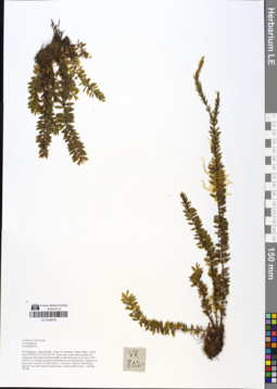
LE 01049678
Phlegmariurus hamiltonii (Spreng.) Á.Löve & D.Löve det. Averyanov, Leonid Vladimirovich at 07.09.2019
Additional identifications: Lycopodium sp. det. Averyanov, Leonid Vladimirovich at 24.04.2018 Collectors: Averyanov, Leonid Vladimirovich; Khang Sinh Nguyen; Tien Hiep Nguyen; Nguyen Quang Hieu; Chuong Quang Ngan; Maisak, Tatiana Viktorovna Field collecting number: VR802. Collection date: 24.04.2018. Administrative regions: VN - Tinh Ha Giang. Groups of specimens: L. V. Averyanov specimens; L. V. Averyanov herbarium; L. V. Averyanov photosOriginal label text:FLORA OF VIETNAM Lycopodiaceae Lycopodium sp. Ha Giang prov., Quan Ba distr., Tung Vai commune, Thang village, around point 23º03ʹ04.2ʺN 104º51ʹ09.7ʺE, steep rocky slopes near mountain top composed with eroded stratified highly eroded limestone at elevation 1200-1450 m a.s.l. Primary evergreen broad-leaved very humid forest. Epiphyte on mossy tree. Not rare. 24 April 2018, L. Averyanov, Nguyen Sinh Khang, Nguyen Tien Hiep, Nguyen Quang Hieu, Chuong Quang Ngan, T. Maisak, VR 802.
Coordinates (geographic position): 23° 3′ 4.2″ N, 104° 51′ 9.7″ E ±1000 mComment: All photos © L. Averyanov & K.S. Nguyen
Record creation: 2019-05-03, Leonid Averyanov, PhotoScan D1Citation: Specimen LE 01049678 // Virtual herbarium of Komarov Botanical Institute RAS — http://re.herbariumle.ru/01049678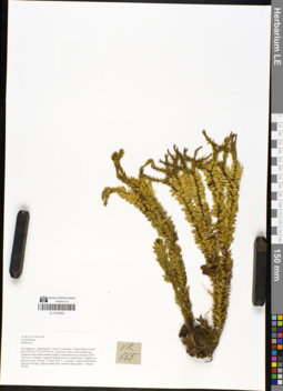
LE 01049693
Phlegmariurus hamiltonii (Spreng.) Á.Löve & D.Löve det. Averyanov, Leonid Vladimirovich at 07.09.2019
Additional identifications: Huperzia sp. det. Averyanov, Leonid Vladimirovich at 22.04.2018 Collectors: Averyanov, Leonid Vladimirovich; Khang Sinh Nguyen; Tien Hiep Nguyen; Nguyen Quang Hieu; Chuong Quang Ngan; Maisak, Tatiana Viktorovna Field collecting number: VR665. Collection date: 22.04.2018. Administrative regions: VN - Tinh Ha Giang. Groups of specimens: L. V. Averyanov specimens; L. V. Averyanov herbarium; L. V. Averyanov photosOriginal label text:FLORA OF VIETNAM Lycopodiaceae Huperzia sp. Ha Giang prov., Quan Ba distr., Tung Vai commune, Thang village, around point 23º03ʹ41.5ʺN 104º50ʹ41.6ʺE, steep rocky slopes near mountain top composed with eroded stratified highly eroded limestone at elevation 1200-1400 m a.s.l. Primary evergreen broad-leaved very humid forest. Epiphyte on tall mossy trees. Not rare. 22 April 2018, L. Averyanov, Nguyen Sinh Khang, Nguyen Tien Hiep, Nguyen Quang Hieu, Chuong Quang Ngan, T. Maisak, VR 665.
Coordinates (geographic position): 23° 3′ 41.5″ N, 104° 50′ 41.6″ E ±1000 mComment: All photos © L. Averyanov & K.S. Nguyen
Record creation: 2019-04-21, Leonid Averyanov, PhotoScan D1Citation: Specimen LE 01049693 // Virtual herbarium of Komarov Botanical Institute RAS — http://re.herbariumle.ru/01049693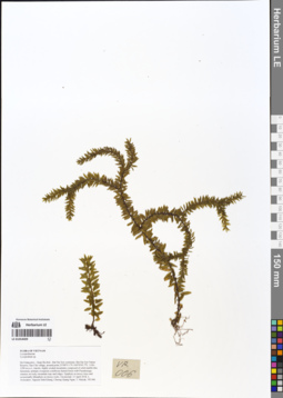
LE 01054009
Phlegmariurus hamiltonii (Spreng.) Á.Löve & D.Löve det. Averyanov, Leonid Vladimirovich at 07.09.2019
Additional identifications: Lycopodium sp. det. Averyanov, Leonid Vladimirovich at 13.03.2018; Phlegmariurus sp. det. X.C.Zhang at 05.07.2019 Collectors: Averyanov, Leonid Vladimirovich; Khang Sinh Nguyen; Tien Hiep Nguyen; Nguyen Quang Hieu; Chuong Quang Ngan; Maisak, Tatiana Viktorovna Field collecting number: VR006. Collection date: 13.04.2018. Administrative regions: VN - Tinh Ha Giang. Groups of specimens: L. V. Averyanov specimens; L. V. Averyanov herbariumOriginal label text:FLORA OF VIETNAM Lycopodiaceae Lycopodium sp. Ha Giang prov., Quan Ba distr., Bat Dai Son commune, Bat Dai Son Nature Reserve, San Chu village, around point 23º08ʹ55.1ʺN 104º59ʹ45.7ʺE, 1100-1290 m a.s.l., karstic, highly eroded mountains composed of solid marble-like limestone, primary evergreen coniferous humid forest with Pseudotsuga sinensis on rocky mountain tops and ridges. Epiphyte on mossy trees and occasionally lithophyte on mossy rocks. Occasional. 13 April 2018, L. Averyanov, Nguyen Sinh Khang, Chuong Quang Ngan, T. Maisak, VR 006.
Comment: All photos © L. Averyanov & K.S. Nguyen
Record creation: 2019-05-03, Leonid Averyanov, PhotoScan D1Citation: Specimen LE 01054009 // Virtual herbarium of Komarov Botanical Institute RAS — http://re.herbariumle.ru/01054009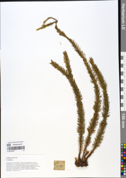
LE 01054429
Phlegmariurus phlegmaria (L.) Holub det. X.C.Zhang at 05.07.2019
Additional identifications: Lycopodium sp. det. Averyanov, Leonid Vladimirovich at 14.04.2018 Collectors: Averyanov, Leonid Vladimirovich; Khang Sinh Nguyen; Chuong Quang Ngan; Maisak, Tatiana Viktorovna Field collecting number: VR117. Collection date: 14.04.2018. Administrative regions: VN - Tinh Ha Giang. Groups of specimens: L. V. Averyanov specimens; L. V. Averyanov herbarium; L. V. Averyanov photosOriginal label text:FLORA OF VIETNAM Lycopodiaceae Lycopodium sp. Ha Giang prov., Quan Ba distr., Bat Dai Son Nature Reserve, Can Ty commune, Dau Cau 1 village, around point 23º05ʹ26.3ʺN 105º01ʹ03.0ʺE, 1100-1150 m a.s.l., karstic, highly eroded mountains composed of solid marble-like limestone, primary evergreen broad-leaved humid forest on steep rocky slopes near mountain tops. Pendulous epiphyte or lithophyte. Occasional. 14 April 2018, L. Averyanov, Nguyen Sinh Khang, Chuong Quang Ngan, T. Maisak, VR 117.
Comment: All photos © L. Averyanov & K.S. Nguyen
Record creation: 2019-05-03, Leonid Averyanov, PhotoScan D1Citation: Specimen LE 01054429 // Virtual herbarium of Komarov Botanical Institute RAS — http://re.herbariumle.ru/01054429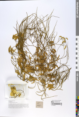
LE 01055323
Lycopodium casuarinoides Spring det. Averyanov, Leonid Vladimirovich at 21.10.2018
Collectors: Averyanov, Leonid Vladimirovich; et al. Field collecting number: VR1142. Collection date: 21.10.2018. Administrative regions: VN - Tinh Ha Giang. Groups of specimens: L. V. Averyanov specimens; L. V. Averyanov herbarium; L. V. Averyanov photosOriginal label text:FLORA OF VIETNAM.
Coordinates (geographic position): 23° 4′ 47.2″ N, 104° 48′ 55.6″ E ±1000 mComment: Lycopodiaceae.
Lycopodium casuarinoides Spring.
Ha Giang prov., Quan Ba distr., Cao Ma Po commune, Chin Chu Lin village, around point 23º04ʹ47.2ʺN 104º48ʹ55.6ʺE, steep slopes and flattened top of mountain composed with sandstone at elevation 1800–1950 m a.s.l. Primary evergreen broad-leaved very humid forest. Pendulous herbaceous vine to 3 m long on open vertical cliff. Not rare. 21 October 2018, L. Averyanov, Nguyen Sinh Khang, T. Maisak, Truong Duc Thieu, VR 1142.
All photos © L. Averyanov & K.S. Nguyen
Record creation: 2019-06-11, Leonid Averyanov, PhotoScan D1Citation: Specimen LE 01055323 // Virtual herbarium of Komarov Botanical Institute RAS — http://re.herbariumle.ru/01055323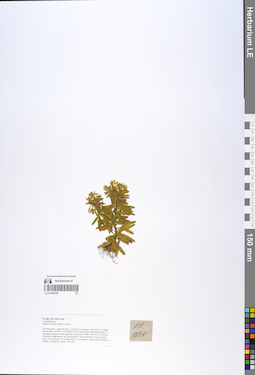
LE 01055398
Huperzia serrata (Thunb.) Trevis. det. Averyanov, Leonid Vladimirovich at 21.10.2018
Collectors: Averyanov, Leonid Vladimirovich; Khang Sinh Nguyen; Maisak, Tatiana Viktorovna; Truong Duc Thieu Field collecting number: VR1134. Collection date: 21.10.2018. Administrative regions: VN - Tinh Ha Giang. Groups of specimens: L. V. Averyanov specimens; L. V. Averyanov herbarium; L. V. Averyanov photosOriginal label text:FLORA OF VIETNAM. Lycopodiaceae. Huperzia serrata (Thunb.)Trevis. Ha Giang prov., Quan Ba distr., Cao Ma Po commune, Chin Chu Lin village, around point 23º04ʹ47.2ʺN 104º48ʹ55.6ʺE, steep slopes and flattened top of mountain composed with sandstone at elevation 1800–1950 m a.s.l. Primary evergreen broad-leaved very humid forest. Terrestrial herb on mossy steep slope. Not common. 21 October 2018, L. Averyanov, Nguyen Sinh Khang, T. Maisak, Truong Duc Thieu, VR 1134.
Coordinates (geographic position): 23° 4′ 47.2″ N, 104° 48′ 55.6″ E ±1000 mComment: All photos © L. Averyanov & K.S. Nguyen
Record creation: 2019-06-11, Leonid Averyanov, PhotoScan D1Citation: Specimen LE 01055398 // Virtual herbarium of Komarov Botanical Institute RAS — http://re.herbariumle.ru/01055398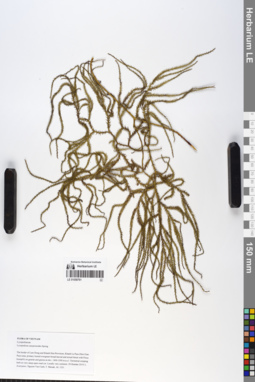
LE 01058761
Lycopodium casuarinoides Spring det. Averyanov, Leonid Vladimirovich at 29.10.2019
Collectors: Averyanov, Leonid Vladimirovich; Nguyen Van Canh; Maisak, Tatiana Viktorovna Field collecting number: AL1231. Collection date: 29.10.2019. Administrative regions: VN - Tinh Lam GJong; VN - Tinh Khanh Hoa. Groups of specimens: L. V. Averyanov specimens; L. V. Averyanov herbariumOriginal label text:FLORA OF VIETNAM Lycopodiaceae Lycopodium casuarinoides Spring The border of Lam Dong and Khanh Hoa Provinces, Khanh Le Pass (Hon Giao Pass) area, primary humid evergreen broad-leaved and mixed forest with Pinus krempfii) on granite and gneiss at elev. 1400-1500 m a.s.l. Terrestrial creeping herb on very steep open road cut. Locally very common. 29 October 2019, L. Averyanov, Nguyen Van Canh, T. Maisak, AL 1231.
Comment: All photos © L.Averyanov
Record creation: 2019-12-14, Leonid Averyanov, PhotoScan D1Citation: Specimen LE 01058761 // Virtual herbarium of Komarov Botanical Institute RAS — http://re.herbariumle.ru/01058761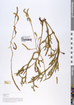
LE 01058762
Lycopodium clavatum L. det. Averyanov, Leonid Vladimirovich at 29.10.2019
Collectors: Averyanov, Leonid Vladimirovich; Nguyen Van Canh; Maisak, Tatiana Viktorovna Field collecting number: AL1230. Collection date: 29.10.2019. Administrative regions: VN - Tinh Lam GJong; VN - Tinh Khanh Hoa. Groups of specimens: L. V. Averyanov specimens; L. V. Averyanov herbariumOriginal label text:FLORA OF VIETNAM Lycopodiaceae Lycopodium clavatum L. The border of Lam Dong and Khanh Hoa Provinces, Khanh Le Pass (Hon Giao Pass) area, primary humid evergreen broad-leaved and mixed forest with Pinus krempfii) on granite and gneiss at elev. 1400-1500 m a.s.l. Terrestrial creeping herb on steep open grassy road cut. Locally very common. 29 October 2019, L. Averyanov, Nguyen Van Canh, T. Maisak, AL 1230.
Comment: All photos © L.Averyanov
Record creation: 2019-12-14, Leonid Averyanov, PhotoScan D1Citation: Specimen LE 01058762 // Virtual herbarium of Komarov Botanical Institute RAS — http://re.herbariumle.ru/01058762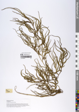
LE 01058765
Lycopodium casuarinoides Spring det. Averyanov, Leonid Vladimirovich at 29.10.2019
Collectors: Averyanov, Leonid Vladimirovich; Nguyen Van Canh; Maisak, Tatiana Viktorovna Field collecting number: AL1231. Collection date: 29.10.2019. Administrative regions: VN - Tinh Lam GJong; VN - Tinh Khanh Hoa. Groups of specimens: L. V. Averyanov specimens; L. V. Averyanov herbariumOriginal label text:FLORA OF VIETNAM Lycopodiaceae Lycopodium casuarinoides Spring The border of Lam Dong and Khanh Hoa Provinces, Khanh Le Pass (Hon Giao Pass) area, primary humid evergreen broad-leaved and mixed forest with Pinus krempfii) on granite and gneiss at elev. 1400-1500 m a.s.l. Terrestrial creeping herb on very steep open road cut. Locally very common. 29 October 2019, L. Averyanov, Nguyen Van Canh, T. Maisak, AL 1231.
Comment: All photos © L.Averyanov
Record creation: 2019-12-14, Leonid Averyanov, PhotoScan D1Citation: Specimen LE 01058765 // Virtual herbarium of Komarov Botanical Institute RAS — http://re.herbariumle.ru/01058765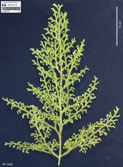
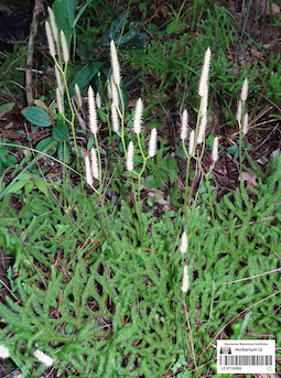
LE 01061119
Lycopodium cernuum L. det. Averyanov, Leonid Vladimirovich at 07.10.2019
Collectors: Averyanov, Leonid Vladimirovich; Khang Sinh Nguyen; Maisak, Tatiana Viktorovna Field collecting number: VR1428. Collection date: 07.10.2019. Administrative regions: VN - Tinh Ha Giang. Groups of specimens: L. V. Averyanov specimens; L. V. Averyanov photosOriginal label text:FLORA OF VIETNAM Lycopodiaceae Lycopodium cernuum L. Ha Giang Prov., Quan Ba Distr., Tung Vai Commune, Thang Village, around point 23.05349ºN 104.86446ºE, steep rocky slopes of river valley composed with eroded limestone mixed with sandstone at elevation 1000–1100 m a.s.l. Remnants of primary evergreen broad-leaved very humid forest along river. Creeping herb with erect stems to 0.5 m tall in open grassy place along trail. Common. 7 October 2019, L. Averyanov, Nguyen Sinh Khang, T. Maisak, VR 1428.
Coordinates (geographic position): 23° 3′ 12.56″ N, 104° 51′ 52.06″ E ±1000 mComment: All photos © L. Averyanov & K.S. Nguyen
Record creation: 2019-12-31, Аверьянов Леонид ВладимировичCitation: Specimen LE 01061119 // Virtual herbarium of Komarov Botanical Institute RAS — http://re.herbariumle.ru/01061119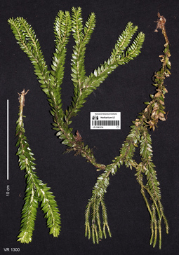
LE 01061234
Phlegmariurus fordii (Baker) Ching det. Averyanov, Leonid Vladimirovich at 04.10.2019
Collectors: Averyanov, Leonid Vladimirovich; Khang Sinh Nguyen; Maisak, Tatiana Viktorovna Field collecting number: VR1300. Collection date: 04.10.2019. Administrative regions: VN - Tinh Ha Giang. Groups of specimens: L. V. Averyanov specimens; L. V. Averyanov photosOriginal label text:FLORA OF VIETNAM
Coordinates (geographic position): 23° 5′ 40.27″ N, 104° 50′ 53.92″ E ±1000 mComment: Lycopodiaceae
Phlegmariurus fordii (Baker) Ching
Ha Giang Prov., Quan Ba Distr., Cao Ma Po Commune, Then Van 1 Village, Binh Mountain, around point 23.09452ºN 104.84831ºE, steep rocky slopes composed with highly eroded limestone at elevation 1400–1600 m a.s.l. Remnants of primary evergreen broad-leaved very humid forest with plantation of “wild-grown” Amomum. Clustering epiphyte on old mossy tree in shady place. Not common. 4 October 2019, L. Averyanov, Nguyen Sinh Khang, T. Maisak, VR 1300.
All photos © L. Averyanov & K.S. Nguyen
Record creation: 2019-12-30, Аверьянов Леонид ВладимировичCitation: Specimen LE 01061234 // Virtual herbarium of Komarov Botanical Institute RAS — http://re.herbariumle.ru/01061234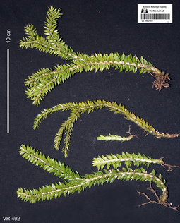
LE 01061412
Huperzia hamiltonii (Spreng.) Trevis. det. Averyanov, Leonid Vladimirovich at 07.09.2019
Additional identifications: Lycopodium sp. det. Averyanov, Leonid Vladimirovich at 19.04.2018 Collectors: Averyanov, Leonid Vladimirovich; Khang Sinh Nguyen; Chuong Quang Ngan; Maisak, Tatiana Viktorovna Field collecting number: VR492. Collection date: 19.04.2018. Administrative regions: VN - Tinh Ha Giang. Groups of specimens: L. V. Averyanov specimens; L. V. Averyanov photosOriginal label text:FLORA OF VIETNAM Lycopodiaceae Lycopodium sp. Ha Giang prov., Quan Ba distr., Bat Dai Son Nature Reserve, Thanh Van commune, Tan village, Thong (Conifer) Mountain, around point 23º07ʹ40.3ʺN 104º57ʹ11.2ʺE, at elevation 1000-1195 m a.s.l., karstic, highly eroded mountains composed of solid marble-like limestone, primary evergreen broad-leaved and coniferous (with Pseudotsuga sinensis) humid forest on steep rocky slopes near mountain tops. Epiphyte on mossy tree on mossy mountain top. Not common. 19 April 2018, L. Averyanov, Nguyen Sinh Khang, Chuong Quang Ngan, T. Maisak, VR 492.
Coordinates (geographic position): 23° 7′ 40.3″ N, 104° 57′ 11.2″ E ±1000 mComment: All photos © L. Averyanov & K.S. Nguyen
Record creation: 2019-08-03, Аверьянов Леонид ВладимировичCitation: Specimen LE 01061412 // Virtual herbarium of Komarov Botanical Institute RAS — http://re.herbariumle.ru/01061412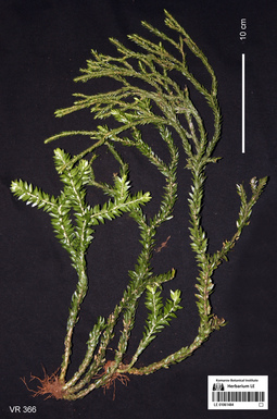
LE 01061484
Phlegmariurus fordii (Baker) Ching det. Averyanov, Leonid Vladimirovich at 07.09.2019
Additional identifications: Lycopodium sp. det. Averyanov, Leonid Vladimirovich at 18.04.2018 Collectors: Averyanov, Leonid Vladimirovich; Khang Sinh Nguyen; Chuong Quang Ngan; Maisak, Tatiana Viktorovna Field collecting number: VR366. Collection date: 18.04.2018. Administrative regions: VN - Tinh Ha Giang. Groups of specimens: L. V. Averyanov specimens; L. V. Averyanov photosOriginal label text:FLORA OF VIETNAM Lycopodiaceae Lycopodium sp. Ha Giang prov., Quan Ba distr., Bat Dai Son Nature Reserve, Thanh Van commune, Mo Sai village, around point 23º07ʹ46.4ʺN 104º57ʹ56.2ʺE, at elevation 1000-1190 m a.s.l., karstic, highly eroded mountains composed of solid marble-like limestone, primary evergreen broad-leaved and mixed (with Pseudotsuga sinensis) humid forest on steep rocky slopes near mountain tops. Epiphyte on mossy tree on rocky mountain slope. Not common. 18 April 2018, L. Averyanov, Nguyen Sinh Khang, Chuong Quang Ngan, T. Maisak, VR 366.
Coordinates (geographic position): 23° 7′ 46.4″ N, 104° 57′ 56.2″ E ±1000 mComment: All photos © L. Averyanov & K.S. Nguyen
Record creation: 2019-07-30, Аверьянов Леонид ВладимировичCitation: Specimen LE 01061484 // Virtual herbarium of Komarov Botanical Institute RAS — http://re.herbariumle.ru/01061484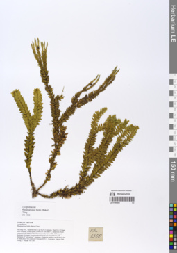
LE 01066900
Phlegmariurus fordii (Baker) Ching det. Averyanov, Leonid Vladimirovich at 10.12.2019
Collectors: Averyanov, Leonid Vladimirovich; Khang Sinh Nguyen; Maisak, Tatiana Viktorovna Field collecting number: VR1300. Collection date: 04.10.2019. Administrative regions: VN - Tinh Ha Giang. Groups of specimens: L. V. Averyanov specimens; L. V. Averyanov herbariumOriginal label text:FLORA OF VIETNAM Lycopodiaceae Phlegmariurus fordii (Baker) Ching Ha Giang Prov., Quan Ba Distr., Cao Ma Po Commune, Then Van 1 Village, Binh Mountain, around point 23.09452ºN 104.84831ºE, steep rocky slopes composed with highly eroded limestone at elevation 1400–1600 m a.s.l. Remnants of primary evergreen broad-leaved very humid forest with plantation of “wild-grown” Amomum. Clustering epiphyte on old mossy tree in shady place. Not common. 4 October 2019, L. Averyanov, Nguyen Sinh Khang, T. Maisak, VR 1300.
Coordinates (geographic position): 23° 5′ 40.27″ N, 104° 50′ 53.92″ E ±1000 mRecord creation: 2019-12-31, Leonid Averyanov, PhotoScan D1Citation: Specimen LE 01066900 // Virtual herbarium of Komarov Botanical Institute RAS — http://re.herbariumle.ru/01066900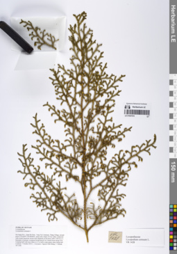
LE 01067016
Lycopodium cernuum L. det. Averyanov, Leonid Vladimirovich at 07.10.2019
Collectors: Averyanov, Leonid Vladimirovich; Khang Sinh Nguyen; Maisak, Tatiana Viktorovna Field collecting number: VR1428. Collection date: 07.10.2019. Administrative regions: VN - Tinh Ha Giang. Groups of specimens: L. V. Averyanov specimens; L. V. Averyanov herbariumOriginal label text:FLORA OF VIETNAM Lycopodiaceae Lycopodium cernuum L. Ha Giang Prov., Quan Ba Distr., Tung Vai Commune, Thang Village, around point 23.05349ºN 104.86446ºE, steep rocky slopes of river valley composed with eroded limestone mixed with sandstone at elevation 1000–1100 m a.s.l. Remnants of primary evergreen broad-leaved very humid forest along river. Creeping herb with erect stems to 0.5 m tall in open grassy place along trail. Common. 7 October 2019, L. Averyanov, Nguyen Sinh Khang, T. Maisak, VR 1428.
Coordinates (geographic position): 23° 3′ 12.56″ N, 104° 51′ 52.06″ E ±1000 mRecord creation: 2019-12-31, Leonid Averyanov, PhotoScan D1Citation: Specimen LE 01067016 // Virtual herbarium of Komarov Botanical Institute RAS — http://re.herbariumle.ru/01067016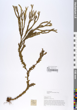
LE 01067046
Phlegmariurus fordii (Baker) Ching det. Averyanov, Leonid Vladimirovich at 10.12.2019
Collectors: Averyanov, Leonid Vladimirovich; Khang Sinh Nguyen; Maisak, Tatiana Viktorovna; Chuong Quang Ngan Field collecting number: VR366. Collection date: 18.04.2018. Administrative regions: VN - Tinh Ha Giang. Groups of specimens: L. V. Averyanov specimens; L. V. Averyanov herbariumOriginal label text:FLORA OF VIETNAM Lycopodiaceae Phlegmariurus fordii (Baker) Ching Ha Giang prov., Quan Ba distr., Bat Dai Son Nature Reserve, Thanh Van commune, Mo Sai village, around point 23º07ʹ46.4ʺN 104º57ʹ56.2ʺE, at elevation 1000-1190 m a.s.l., karstic, highly eroded mountains composed of solid marble-like limestone, primary evergreen broad-leaved and mixed (with Pseudotsuga sinensis) humid forest on steep rocky slopes near mountain tops. Epiphyte on mossy tree on rocky mountain slope. Not common. 18 April 2018, L. Averyanov, Nguyen Sinh Khang, Chuong Quang Ngan, T. Maisak, VR 366 (HN, LE01061484 – photo).
Coordinates (geographic position): 23° 7′ 46.4″ N, 104° 57′ 56.2″ E ±1000 mComment: All photos © L. Averyanov & K.S. Nguyen
Record creation: 2020-01-05, Leonid Averyanov, PhotoScan D1Citation: Specimen LE 01067046 // Virtual herbarium of Komarov Botanical Institute RAS — http://re.herbariumle.ru/01067046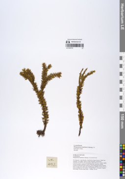
LE 01067315
Phlegmariurus hamiltonii (Spreng.) Á.Löve & D.Löve det. Averyanov, Leonid Vladimirovich at 10.12.2019
Collectors: Averyanov, Leonid Vladimirovich; Khang Sinh Nguyen; Maisak, Tatiana Viktorovna; Chuong Quang Ngan Field collecting number: VR492. Collection date: 19.04.2018. Administrative regions: VN - Tinh Ha Giang. Groups of specimens: L. V. Averyanov specimens; L. V. Averyanov herbariumOriginal label text:FLORA OF VIETNAM Lycopodiaceae Phlegmariurus hamiltonii (Spreng.) Á. Löve & D. Löve Ha Giang prov., Quan Ba distr., Bat Dai Son Nature Reserve, Thanh Van commune, Tan village, Thong (Conifer) Mountain, around point 23º07ʹ40.3ʺN 104º57ʹ11.2ʺE, at elevation 1000-1195 m a.s.l., karstic, highly eroded mountains composed of solid marble-like limestone, primary evergreen broad-leaved and coniferous (with Pseudotsuga sinensis) humid forest on steep rocky slopes near mountain tops. Epiphyte on mossy tree on mossy mountain top. Not common. 19 April 2018, L. Averyanov, Nguyen Sinh Khang, Chuong Quang Ngan, T. Maisak, VR 492 (HN, LE01061412 – photo).
Coordinates (geographic position): 23° 7′ 40.3″ N, 104° 57′ 11.2″ E ±1000 mComment: All photos © L. Averyanov & K.S. Nguyen
Record creation: 2020-01-05, Leonid Averyanov, PhotoScan D1Citation: Specimen LE 01067315 // Virtual herbarium of Komarov Botanical Institute RAS — http://re.herbariumle.ru/01067315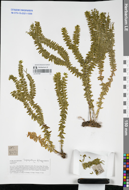
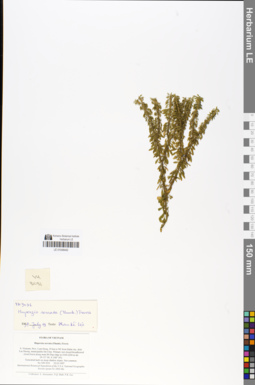
LE 01077407
Lycopodium phlegmaria L. det. Averyanov, Leonid Vladimirovich
Additional identifications: Huperzia sp. det. Averyanov, Leonid Vladimirovich at 24.09.2016 Collectors: Averyanov, Leonid Vladimirovich; et al. Field collecting number: CPC8021. Collection date: 24.09.2016. Administrative regions: VN - Tinh Son La. Groups of specimens: L. V. Averyanov specimens; L. V. Averyanov herbarium; Соглашение Минобрнауки №075-15-2021-1056Original label text:FLORA OF VIETNAM
Lycopodiaceae
Huperzia sp.
Son La Prov., Moc Chau Distr., Chieng Son comm., Pha Luong village, Pha Luong Mountain system. Primary broad-leaved evergreen forest with Pinus cernua, Fokienia hodginsii and bamboo on eroded red-brown sandstone near mountain top at elevation 1350 m a.s.l. around point 20°41′36.4N 104°37′46.6E. Epiphyte. Not common.
24 September 2016 CPC 8021
Coll.: L.Averyanov, N.T.Hiep, N.S.Khang, C.Q.Ngan, T.V.Maisak, N.T.Son.
Record creation: 2021-11-24, Tatiana Maisak, PhotoScan D2. Processing status: work_status_1Citation: Specimen LE 01077407 // Virtual herbarium of Komarov Botanical Institute RAS — http://re.herbariumle.ru/01077407Lycopodiaceae
Huperzia sp.
Son La Prov., Moc Chau Distr., Chieng Son comm., Pha Luong village, Pha Luong Mountain system. Primary broad-leaved evergreen forest with Pinus cernua, Fokienia hodginsii and bamboo on eroded red-brown sandstone near mountain top at elevation 1350 m a.s.l. around point 20°41′36.4N 104°37′46.6E. Epiphyte. Not common.
24 September 2016 CPC 8021
Coll.: L.Averyanov, N.T.Hiep, N.S.Khang, C.Q.Ngan, T.V.Maisak, N.T.Son.
LE 01077408
Lycopodium sp. det. Averyanov, Leonid Vladimirovich at 27.09.2016
Collectors: Averyanov, Leonid Vladimirovich; et al. Field collecting number: CPC8071. Collection date: 27.09.2016. Administrative regions: VN - Tinh Son La. Groups of specimens: L. V. Averyanov specimens; L. V. Averyanov herbarium; Соглашение Минобрнауки №075-15-2021-1056Original label text:FLORA OF VIETNAM
Lycopodiaceae
Lycopodium sp.
Son La Prov., Moc Chau Distr., Chieng Son comm., about 1 km to NE from Chieng Son Village, around point 20°46′02.0N 104°37′03.1E.
Remnants of primary broad-leaved evergreen forest on tops of hills composed with karstic highly eroded yellow-white limestone at elevation 1150-1250 m a.s.l.
Epiphyte on old mossy tree on mountain top. Rare.
27 September 2016 CPC 8071
Coll.: L.Averyanov, N.T.Hiep, N.S.Khang, C.Q.Ngan, T.V.Maisak, N.T.Son.
Coordinates (geographic position): 20° 46′ 2″ N, 104° 37′ 3.1″ E ±1000 mRecord creation: 2021-11-24, Tatiana Maisak, PhotoScan D2. Processing status: work_status_1Citation: Specimen LE 01077408 // Virtual herbarium of Komarov Botanical Institute RAS — http://re.herbariumle.ru/01077408Lycopodiaceae
Lycopodium sp.
Son La Prov., Moc Chau Distr., Chieng Son comm., about 1 km to NE from Chieng Son Village, around point 20°46′02.0N 104°37′03.1E.
Remnants of primary broad-leaved evergreen forest on tops of hills composed with karstic highly eroded yellow-white limestone at elevation 1150-1250 m a.s.l.
Epiphyte on old mossy tree on mountain top. Rare.
27 September 2016 CPC 8071
Coll.: L.Averyanov, N.T.Hiep, N.S.Khang, C.Q.Ngan, T.V.Maisak, N.T.Son.
LE 01077409
Huperzia sp. det. Averyanov, Leonid Vladimirovich at 02.10.2016
Collectors: Averyanov, Leonid Vladimirovich; et al. Field collecting number: CPC8215. Collection date: 02.10.2016. Administrative regions: VN - Tinh Son La. Groups of specimens: L. V. Averyanov specimens; L. V. Averyanov herbarium; Соглашение Минобрнауки №075-15-2021-1056Original label text:FLORA OF VIETNAM
Lycopodiaceae
Huperzia sp.
Son La Prov., Van Ho Distr., Van Ho comm., Hua Tat village, around point 20°46′21.7N 104°47′47.5E.
Remnants of primary evergreen broad-leaved and mixed forest (with Pinus wangii) on very steep rocky slopes and on mountain tops composed with highly eroded karstic light gray marble-like limestone at elevation 1300-1350 m a.s.l.
Epiphytic and lithophytic pendulous herb. Rare.
2 October 2016 CPC 8215
Coll.: L.Averyanov, N.T.Hiep, N.S.Khang, C.Q.Ngan, T.V.Maisak, N.T.Son.
Coordinates (geographic position): 20° 46′ 21.7″ N, 104° 47′ 47.5″ E ±1000 mRecord creation: 2021-11-24, Tatiana Maisak, PhotoScan D2. Processing status: work_status_1Citation: Specimen LE 01077409 // Virtual herbarium of Komarov Botanical Institute RAS — http://re.herbariumle.ru/01077409Lycopodiaceae
Huperzia sp.
Son La Prov., Van Ho Distr., Van Ho comm., Hua Tat village, around point 20°46′21.7N 104°47′47.5E.
Remnants of primary evergreen broad-leaved and mixed forest (with Pinus wangii) on very steep rocky slopes and on mountain tops composed with highly eroded karstic light gray marble-like limestone at elevation 1300-1350 m a.s.l.
Epiphytic and lithophytic pendulous herb. Rare.
2 October 2016 CPC 8215
Coll.: L.Averyanov, N.T.Hiep, N.S.Khang, C.Q.Ngan, T.V.Maisak, N.T.Son.
LE 01077410
Lycopodium phlegmaria L. ⟮prelim. ID⟯ det. Averyanov, Leonid Vladimirovich at 28.03.2017
Collectors: Averyanov, Leonid Vladimirovich; et al. Field collecting number: LA-VN1867. Collection date: 28.03.2017. Administrative regions: LA - Vientiane Province. Groups of specimens: L. V. Averyanov specimens; L. V. Averyanov herbarium; Соглашение Минобрнауки №075-15-2021-1056Original label text:FLORA OF LAOS
Lycopodiaceae
Lycopodium phlegmaria L.?
Vientiane prov., Kasi distr., Si Sang Vone village, around point 19°06′10.9′'N 102°10′46.1′'E.
Secondary and primary evergreen dry forest on very steep rocky mountain slopes composed by solid marble like highly eroded limestone at elev. 600-750 m a.s.l.
Clustering epiphytic and occasionally lithophytic herb on rocky mossy mountain top. Not common.
LA-VN 1867 28 March 2017
Coll.: L.Averyanov, N.T.Hiep, N.S.Khang, C.Q.Ngan, T.Maisak, Khamla Inkhavilay, Hongthong Southyvohanh, Pinmany Sisavath, Chanthala Cheuaysamphanh.
Coordinates (geographic position): 19° 6′ 10.9″ N, 102° 10′ 46.1″ E ±1000 mRecord creation: 2021-11-24, Tatiana Maisak, PhotoScan D2. Processing status: work_status_1Citation: Specimen LE 01077410 // Virtual herbarium of Komarov Botanical Institute RAS — http://re.herbariumle.ru/01077410Lycopodiaceae
Lycopodium phlegmaria L.?
Vientiane prov., Kasi distr., Si Sang Vone village, around point 19°06′10.9′'N 102°10′46.1′'E.
Secondary and primary evergreen dry forest on very steep rocky mountain slopes composed by solid marble like highly eroded limestone at elev. 600-750 m a.s.l.
Clustering epiphytic and occasionally lithophytic herb on rocky mossy mountain top. Not common.
LA-VN 1867 28 March 2017
Coll.: L.Averyanov, N.T.Hiep, N.S.Khang, C.Q.Ngan, T.Maisak, Khamla Inkhavilay, Hongthong Southyvohanh, Pinmany Sisavath, Chanthala Cheuaysamphanh.
LE 01077411
Lycopodium sp. det. Averyanov, Leonid Vladimirovich at 01.04.2017
Collectors: Averyanov, Leonid Vladimirovich Field collecting number: LA-VN1968. Collection date: 01.04.2017. Administrative regions: LA - Luang Prabang Province. Groups of specimens: L. V. Averyanov specimens; L. V. Averyanov herbarium; Соглашение Минобрнауки №075-15-2021-1056Original label text:FLORA OF LAOS
Lycopodiaceae
Lycopodium sp.
Luang Prabang prov., Ngoy distr., Ngoy village, Pha Noi Mountain, around point 20°42′53.6′'N 102°40′34.7′'E.
Remnants of primary evergreen forest on very steep rocky mountain slopes composed by solid marble like highly eroded limestone at elev. 400-450 m a.s.l.
Epiphyte on rocky mossy mountain top. Not common.
LA-VN 1968 1 April 2017
Coll.: L.Averyanov, N.T.Hiep, N.S.Khang, C.Q.Ngan, T.Maisak, Vichith Lamxay, Koudkeo Phommachanh, Phizar Sayalath, Keooudone Souvannakhoummane.
Coordinates (geographic position): 20° 42′ 53.6″ N, 102° 40′ 34.7″ E ±1000 mRecord creation: 2021-11-24, Tatiana Maisak, PhotoScan D2. Processing status: work_status_1Citation: Specimen LE 01077411 // Virtual herbarium of Komarov Botanical Institute RAS — http://re.herbariumle.ru/01077411Lycopodiaceae
Lycopodium sp.
Luang Prabang prov., Ngoy distr., Ngoy village, Pha Noi Mountain, around point 20°42′53.6′'N 102°40′34.7′'E.
Remnants of primary evergreen forest on very steep rocky mountain slopes composed by solid marble like highly eroded limestone at elev. 400-450 m a.s.l.
Epiphyte on rocky mossy mountain top. Not common.
LA-VN 1968 1 April 2017
Coll.: L.Averyanov, N.T.Hiep, N.S.Khang, C.Q.Ngan, T.Maisak, Vichith Lamxay, Koudkeo Phommachanh, Phizar Sayalath, Keooudone Souvannakhoummane.
LE 01077412
Lycopodium phlegmaria L. det. Averyanov, Leonid Vladimirovich
Additional identifications: Huperzia sp. det. Averyanov, Leonid Vladimirovich at 23.03.2017 Collectors: Averyanov, Leonid Vladimirovich; et al. Field collecting number: LA-VN1574. Collection date: 23.03.2017. Administrative regions: LA - Vientiane Province. Groups of specimens: L. V. Averyanov specimens; L. V. Averyanov herbarium; Соглашение Минобрнауки №075-15-2021-1056Original label text:FLORA OF LAOS
Lycopodiaceae
Huperzia sp.
Vientiane prov., Vang Vieng distr., Patang village, around point 19°04′15.6′'N 102°24′33.2′'E. Secondary broad-leaved semi-deciduous dry forest on very steep rocky mountain slopes composed by solid marble like highly eroded limestone at elev. about 670 m a.s.l. Epiphyte with pendulous stems to 0.5 m long. Not common.
LA-VN 1574 23 March 2017
Coll.: L.Averyanov, N.T.Hiep, N.S.Khang, C.Q.Ngan, T.Maisak, Khamla Inkhavilay, Hongthong Southyvohanh, Pinmany Sisavath, Chanthala Cheuaysamphanh.
Coordinates (geographic position): 19° 4′ 15.6″ N, 102° 24′ 33.2″ E ±1000 mRecord creation: 2021-11-24, Tatiana Maisak, PhotoScan D2. Processing status: work_status_1Citation: Specimen LE 01077412 // Virtual herbarium of Komarov Botanical Institute RAS — http://re.herbariumle.ru/01077412Lycopodiaceae
Huperzia sp.
Vientiane prov., Vang Vieng distr., Patang village, around point 19°04′15.6′'N 102°24′33.2′'E. Secondary broad-leaved semi-deciduous dry forest on very steep rocky mountain slopes composed by solid marble like highly eroded limestone at elev. about 670 m a.s.l. Epiphyte with pendulous stems to 0.5 m long. Not common.
LA-VN 1574 23 March 2017
Coll.: L.Averyanov, N.T.Hiep, N.S.Khang, C.Q.Ngan, T.Maisak, Khamla Inkhavilay, Hongthong Southyvohanh, Pinmany Sisavath, Chanthala Cheuaysamphanh.
LE 01077413
Huperzia sp. det. Averyanov, Leonid Vladimirovich at 25.03.2017
Collectors: Averyanov, Leonid Vladimirovich; et al. Field collecting number: LA-VN1619. Collection date: 25.03.2017. Administrative regions: LA - Vientiane Province. Groups of specimens: L. V. Averyanov specimens; L. V. Averyanov herbarium; Соглашение Минобрнауки №075-15-2021-1056Original label text:FLORA OF LAOS
Lycopodiaceae
Huperzia sp.
Vientiane prov., Kasi distr., between San and Tham Tai villages, around point 19°17′47.9′'N 102°08′58.9′'E.
Secondary broad-leaved evergreen dry forest on very steep rocky mountain slopes composed by solid marble like highly eroded limestone at elev. 900-1000 m a.s.l.
Epiphyte on tall mossy tree on steep stream slope. Occasional.
LA-VN 1619 25 March 2017
Coll.: L.Averyanov, N.T.Hiep, N.S.Khang, C.Q.Ngan, T.Maisak, Khamla Inkhavilay, Hongthong Southyvohanh, Pinmany Sisavath, Chanthala Cheuaysamphanh.
Coordinates (geographic position): 19° 17′ 47.9″ N, 102° 8′ 58.9″ E ±1000 mRecord creation: 2021-11-24, Tatiana Maisak, PhotoScan D2. Processing status: work_status_1Citation: Specimen LE 01077413 // Virtual herbarium of Komarov Botanical Institute RAS — http://re.herbariumle.ru/01077413Lycopodiaceae
Huperzia sp.
Vientiane prov., Kasi distr., between San and Tham Tai villages, around point 19°17′47.9′'N 102°08′58.9′'E.
Secondary broad-leaved evergreen dry forest on very steep rocky mountain slopes composed by solid marble like highly eroded limestone at elev. 900-1000 m a.s.l.
Epiphyte on tall mossy tree on steep stream slope. Occasional.
LA-VN 1619 25 March 2017
Coll.: L.Averyanov, N.T.Hiep, N.S.Khang, C.Q.Ngan, T.Maisak, Khamla Inkhavilay, Hongthong Southyvohanh, Pinmany Sisavath, Chanthala Cheuaysamphanh.
LE 01077414
Huperzia sp. det. Averyanov, Leonid Vladimirovich at 23.03.2017
Collectors: Averyanov, Leonid Vladimirovich; et al. Field collecting number: LA-VN1573. Collection date: 23.03.2017. Administrative regions: LA - Vientiane Province. Groups of specimens: L. V. Averyanov specimens; L. V. Averyanov herbarium; Соглашение Минобрнауки №075-15-2021-1056Original label text:FLORA OF LAOS
Lycopodiaceae
Huperzia sp.
Vientiane prov., Vang Vieng distr., Patang village, around point 19°04′15.6′'N 102°24′33.2′'E.
Secondary broad-leaved semi-deciduous dry forest on very steep rocky mountain slopes composed by solid marble like highly eroded limestone at elev. about 670 m a.s.l.
Epiphyte with pendulous stems to 0.5 m long. Not common.
LA-VN 1573 23 March 2017
Coll.: L.Averyanov, N.T.Hiep, N.S.Khang, C.Q.Ngan, T.Maisak, Khamla Inkhavilay, Hongthong Southyvohanh, Pinmany Sisavath, Chanthala Cheuaysamphanh.
Coordinates (geographic position): 19° 4′ 15.6″ N, 102° 24′ 33.2″ E ±1000 mRecord creation: 2021-11-24, Tatiana Maisak, PhotoScan D2. Processing status: work_status_1Citation: Specimen LE 01077414 // Virtual herbarium of Komarov Botanical Institute RAS — http://re.herbariumle.ru/01077414Lycopodiaceae
Huperzia sp.
Vientiane prov., Vang Vieng distr., Patang village, around point 19°04′15.6′'N 102°24′33.2′'E.
Secondary broad-leaved semi-deciduous dry forest on very steep rocky mountain slopes composed by solid marble like highly eroded limestone at elev. about 670 m a.s.l.
Epiphyte with pendulous stems to 0.5 m long. Not common.
LA-VN 1573 23 March 2017
Coll.: L.Averyanov, N.T.Hiep, N.S.Khang, C.Q.Ngan, T.Maisak, Khamla Inkhavilay, Hongthong Southyvohanh, Pinmany Sisavath, Chanthala Cheuaysamphanh.
LE 01077721
Huperzia sp. det. Averyanov, Leonid Vladimirovich at 22.03.2017
Collectors: Averyanov, Leonid Vladimirovich; Tien Hiep Nguyen; Khang Sinh Nguyen; et al. Field collecting number: LA-VN1532. Collection date: 22.03.2017. Administrative regions: LA - Vientiane Province. Groups of specimens: L. V. Averyanov specimens; L. V. Averyanov herbarium; Соглашение Минобрнауки №075-15-2021-1056Original label text:FLORA OF LAOS
Lycopodiaceae
Huperzia sp.
Vientiane prov., Vang Vieng distr., Oa Hom village, around point 19°05′57.0′'N 102°23′19.9′'E.
Secondary broad-leaved evergreen and semideciduous dry forest with on very steep rocky mountain slopes composed by solid marble like highly eroded limestone at elev. 650-750 m a.s.l.
Epiphyte on mossy tree on rocky mountain top. Occasional.
LA-VN 1532 22 March 2017
Coll.: L.Averyanov, N.T.Hiep, N.S.Khang, C.Q.Ngan, T.Maisak, Khamla Inkhavilay, Hongthong Southyvohanh, Pinmany Sisavath, Chanthala Cheuaysamphanh.
Coordinates (geographic position): 19° 5′ 57″ N, 102° 23′ 19.9″ E ±1000 mRecord creation: 2021-12-02, Tatiana Maisak, PhotoScan D2Citation: Specimen LE 01077721 // Virtual herbarium of Komarov Botanical Institute RAS — http://re.herbariumle.ru/01077721Lycopodiaceae
Huperzia sp.
Vientiane prov., Vang Vieng distr., Oa Hom village, around point 19°05′57.0′'N 102°23′19.9′'E.
Secondary broad-leaved evergreen and semideciduous dry forest with on very steep rocky mountain slopes composed by solid marble like highly eroded limestone at elev. 650-750 m a.s.l.
Epiphyte on mossy tree on rocky mountain top. Occasional.
LA-VN 1532 22 March 2017
Coll.: L.Averyanov, N.T.Hiep, N.S.Khang, C.Q.Ngan, T.Maisak, Khamla Inkhavilay, Hongthong Southyvohanh, Pinmany Sisavath, Chanthala Cheuaysamphanh.
LE 01123154
Lycopodium cernuum L. det. Averyanov, Leonid Vladimirovich at 14.05.2022
Collectors: Averyanov, Leonid Vladimirovich; Tran Huy Thai; Khang Sinh Nguyen; Cuong Huu Nguyen; Maisak, Tatiana Viktorovna; et al. Field collecting number: VR1603a. Collection date: 14.05.2022. Administrative regions: VN - Tinh Dien Bien. Groups of specimens: L. V. Averyanov specimens; L. V. Averyanov photos; Images of plants from the Indochinese Peninsula (Cambodia, Laos, Thailand, Vietnam and surrounding areas); Соглашение Минобрнауки №075-15-2021-1056Original label text:FLORA OF VIETNAM
Lycopodiaceae
Lycopodium cernuum L.
Dien Bien Prov., Muong Nhe Distr., Muong Nhe Natural Reserve, Sin Thau Municipality, Ta Mieu Village around point about N 22º24’02’’ E 102º08’38”. Old humid secondary evergreen broad-leaved montane forest of very steep mountain slopes composed with sandstone at elevations 1800–1850 m a.s.l. Erect terrestrial herb to 0.5 m tall on wet open road cut. Common.
14 May 2022, L. Averyanov, Tran Huy Thai, Khang Sinh Nguyen, Cuong Huu Nguyen, T. Maisak, Bac Cam Khoa, VR 1603a.
All photos © - L. Averyanov, K.S. Nguyen, C.H. Nguyen
LE 01124582
Lycopodium clavatum L. det. Averyanov, Leonid Vladimirovich at 08.11.2023
Collectors: Averyanov, Leonid Vladimirovich; Nguyen Van Canh; Truong Ba Vuong; Maisak, Tatiana Viktorovna Field collecting number: AL2525. Collection date: 08.11.2023. Administrative regions: VN - Tinh Lam GJong. Groups of specimens: L. V. Averyanov specimens; L. V. Averyanov photos; Flora of VietnamOriginal label text:FLORA OF VIETNAM
Lycopodiaceae
Lycopodium clavatum L.
Lam Dong Province, Lac Duong District, Bidoup Nui Ba National Par, southern slopes of Bidoup Mountain about 5 km to the south from Bidoup peak around point 12º04.076’N 108º38.927E. Open grassy Pinus kesiya forest and woodlands at elevation about 1900 m a.s.l. Creeping herb in open place. Occasional.
08 November 2023, L. Averyanov, Nguyen Van Canh, Truong Ba Vuong, T. Maisak, AL2525 (BD 032).
All photos © - L. Averyanov
LE 01169596
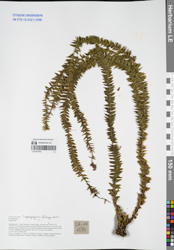
Lycopodium squarrosum G. Forst. det. Averyanov, Leonid Vladimirovich at 02.11.2022
Collectors: Nguyen Huu Cuong Field collecting number: CLL0253. Collection date: 2019. Administrative regions: VN - Tinh Thanh Hoa. Groups of specimens: L. V. Averyanov specimens; L. V. Averyanov herbarium; Соглашение Минобрнауки №075-15-2021-1056Original label text:FLORA OF VIETNAM
Record creation: 2023-04-03, Galina Savich, PhotoScan D2.. Processing status: work_status_1Citation: Specimen LE 01169596 // Virtual herbarium of Komarov Botanical Institute RAS — http://re.herbariumle.ru/01169596Lycopodiaceae
Lycopodium squarrosum G. Forst.
Thanh Hoa Prov.
Nguyen Huu Cuong.
CLL0253, 2019.
Det. Averyanov, Leonid Vladimirovich at 02.11.2022
LE 01253973
Huperzia serrata (Thunb.) Trevis. det. Averyanov, Leonid Vladimirovich at 15.02.2024
Collectors: Averyanov, Leonid Vladimirovich; Nguyen Van Canh; Truong Ba Vuong; Maisak, Tatiana Viktorovna Field collecting number: AL2589. Collection date: 08.11.2023. Administrative regions: VN - Tinh Lam GJong. Groups of specimens: Образцы общего сектора; L. V. Averyanov specimens; L. V. Averyanov herbarium; Соглашение Минобрнауки №075-15-2021-1056; Flora of VietnamOriginal label text:Lycopodiaceae
Hupperzia sp.
Lam Dong Province, Lac Duong District, Bidoup Nui Ba National Par, southern slopes of Bidoup Mountain about 5 km to the south from Bidoup peak around point 12º04.076’N 108º38.927E. Primary broad-leaved evergreen forest on granite slopes at elevation about 2200 m a.s.l. Clustering epiphyte on mossy tree. Not rare.
08 November 2023, L. Averyanov, Nguyen Van Canh, Truong Ba Vuong, T. Maisak, AL2589.
LE 01253974
Lycopodium clavatum L. det. Averyanov, Leonid Vladimirovich at 08.11.2023
Collectors: Averyanov, Leonid Vladimirovich; Nguyen Van Canh; Truong Ba Vuong; Maisak, Tatiana Viktorovna Field collecting number: AL2525. Collection date: 08.11.2023. Administrative regions: VN - Tinh Lam GJong. Groups of specimens: Образцы общего сектора; L. V. Averyanov specimens; L. V. Averyanov herbarium; Соглашение Минобрнауки №075-15-2021-1056; Flora of VietnamOriginal label text:FLORA OF VIETNAM
Lycopodiaceae
Lycopodium clavatum L.
Lam Dong Province, Lac Duong District, Bidoup Nui Ba National Par, southern slopes of Bidoup Mountain about 5 km to the south from Bidoup peak around point 12º04.076’N 108º38.927E. Open grassy Pinus kesiya forest and woodlands at elevation about 1900 m a.s.l. Creeping herb in open place. Occasional.
08 November 2023, L. Averyanov, Nguyen Van Canh, Truong Ba Vuong, T. Maisak, AL2525 (BD 032).