View
Add
Copy
Edit
Delete
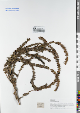
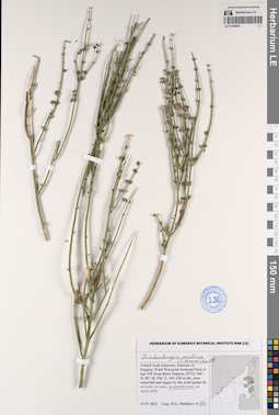
LE 01077511
Lindenbergia philippensis (Cham. & Schltdl.) Benth. det. Averyanov, Leonid Vladimirovich at 05.04.2017
Collectors: Averyanov, Leonid Vladimirovich; et al. Field collecting number: LA-VN2147. Collection date: 05.04.2017. Administrative regions: LA - Luang Prabang Province. Groups of specimens: L. V. Averyanov specimens; L. V. Averyanov herbarium; Соглашение Минобрнауки №075-15-2021-1056Original label text:FLORA OF LAOS
Scrophulariaceae
Lindenbergia philippensis Benth.
Luang Prabang prov., Pon Xay distr., along the way to Bane Phou Souong village, Pha Hiua Bin Toc Mountain, around point 19°57′37.0′'N 102°25′03.0′'E.
Degraded primary evergreen and semideciduous forest on very steep rocky mountain slopes composed by solid marble like highly eroded limestone at elev. 600-850 m a.s.l.
Terrestrial herb to 1 m tall on open rocky slope. Flowers yellow. Not rare.
LA-VN 2147 5 April 2017
Coll.: L.Averyanov, N.T.Hiep, N.S.Khang, C.Q.Ngan, T.Maisak, Vichith Lamxay, Koudkeo Phommachanh, Phizar Sayalath, Keooudone Souvannakhoummane.
Coordinates (geographic position): 19° 57′ 37″ N, 102° 25′ 3″ E ±1000 mRecord creation: 2021-11-24, Tatiana Maisak, PhotoScan D2. Processing status: work_status_1Citation: Specimen LE 01077511 // Virtual herbarium of Komarov Botanical Institute RAS — http://re.herbariumle.ru/01077511Scrophulariaceae
Lindenbergia philippensis Benth.
Luang Prabang prov., Pon Xay distr., along the way to Bane Phou Souong village, Pha Hiua Bin Toc Mountain, around point 19°57′37.0′'N 102°25′03.0′'E.
Degraded primary evergreen and semideciduous forest on very steep rocky mountain slopes composed by solid marble like highly eroded limestone at elev. 600-850 m a.s.l.
Terrestrial herb to 1 m tall on open rocky slope. Flowers yellow. Not rare.
LA-VN 2147 5 April 2017
Coll.: L.Averyanov, N.T.Hiep, N.S.Khang, C.Q.Ngan, T.Maisak, Vichith Lamxay, Koudkeo Phommachanh, Phizar Sayalath, Keooudone Souvannakhoummane.
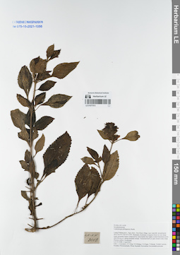
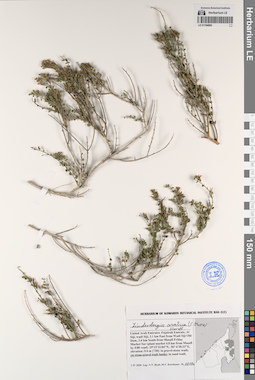
LE 01077513
Lindenbergia philippensis (Cham. & Schltdl.) Benth. det. Averyanov, Leonid Vladimirovich at 02.04.2017
Collectors: Averyanov, Leonid Vladimirovich; et al. Field collecting number: LA-VN2008. Collection date: 02.04.2017. Administrative regions: LA - Luang Prabang Province. Groups of specimens: L. V. Averyanov specimens; L. V. Averyanov herbarium; Соглашение Минобрнауки №075-15-2021-1056Original label text:FLORA OF LAOS
Scrophulariaceae
Lindenbergia philippensis Benth.
Luang Prabang prov., Ngoy distr., Don Khun village, near waterfall, around point 20°31′36.9′'N 102°35′15.8′'E.
Remnants of primary evergreen forest on very steep rocky mountain slopes composed by solid marble like highly eroded limestone at elev. 450-550 m a.s.l. along mountain stream.
Terrestrial herb on open stream rocky slope. Flowers yellow. Occasional.
LA-VN 2008 2 April 2017
Coll.: L.Averyanov, N.T.Hiep, N.S.Khang, C.Q.Ngan, T.Maisak, Vichith Lamxay, Koudkeo Phommachanh, Phizar Sayalath, Keooudone Souvannakhoummane.
Coordinates (geographic position): 20° 31′ 36.9″ N, 102° 35′ 15.8″ E ±1000 mRecord creation: 2021-11-24, Tatiana Maisak, PhotoScan D2. Processing status: work_status_1Citation: Specimen LE 01077513 // Virtual herbarium of Komarov Botanical Institute RAS — http://re.herbariumle.ru/01077513Scrophulariaceae
Lindenbergia philippensis Benth.
Luang Prabang prov., Ngoy distr., Don Khun village, near waterfall, around point 20°31′36.9′'N 102°35′15.8′'E.
Remnants of primary evergreen forest on very steep rocky mountain slopes composed by solid marble like highly eroded limestone at elev. 450-550 m a.s.l. along mountain stream.
Terrestrial herb on open stream rocky slope. Flowers yellow. Occasional.
LA-VN 2008 2 April 2017
Coll.: L.Averyanov, N.T.Hiep, N.S.Khang, C.Q.Ngan, T.Maisak, Vichith Lamxay, Koudkeo Phommachanh, Phizar Sayalath, Keooudone Souvannakhoummane.
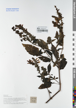
LE 01077514
Lindenbergia philippensis (Cham. & Schltdl.) Benth. det. Averyanov, Leonid Vladimirovich at 22.04.2017
Collectors: Averyanov, Leonid Vladimirovich; et al. Field collecting number: LA-VN1509. Collection date: 22.04.2017. Administrative regions: LA - Vientiane Province. Groups of specimens: L. V. Averyanov specimens; L. V. Averyanov herbarium; Соглашение Минобрнауки №075-15-2021-1056Original label text:FLORA OF LAOS
Scrophulariaceae
Lindenbergia philippensis Benth.
Vientiane prov., Vang Vieng distr., Oa Hom village, around point 19°06′52.4′'N 102°22′35.8′'E.
Secondary broad-leaved evergreen and semideciduous dry forest with on very steep rocky mountain slopes composed by solid marble like highly eroded limestone at elev. 550-650 m a.s.l.
Terrestrial and lithophytic herb to 0.5 m tall in open place of steep rocky slope. Flowers yellow. Occasional.
LA-VN 1509 22 March 2017
Coll.: L.Averyanov, N.T.Hiep, N.S.Khang, C.Q.Ngan, T.Maisak, Khamla Inkhavilay, Hongthong Southyvohanh, Pinmany Sisavath, Chanthala Cheuaysamphanh.
Coordinates (geographic position): 19° 6′ 52.4″ N, 102° 22′ 35.8″ E ±1000 mRecord creation: 2021-11-24, Tatiana Maisak, PhotoScan D2. Processing status: work_status_1Citation: Specimen LE 01077514 // Virtual herbarium of Komarov Botanical Institute RAS — http://re.herbariumle.ru/01077514Scrophulariaceae
Lindenbergia philippensis Benth.
Vientiane prov., Vang Vieng distr., Oa Hom village, around point 19°06′52.4′'N 102°22′35.8′'E.
Secondary broad-leaved evergreen and semideciduous dry forest with on very steep rocky mountain slopes composed by solid marble like highly eroded limestone at elev. 550-650 m a.s.l.
Terrestrial and lithophytic herb to 0.5 m tall in open place of steep rocky slope. Flowers yellow. Occasional.
LA-VN 1509 22 March 2017
Coll.: L.Averyanov, N.T.Hiep, N.S.Khang, C.Q.Ngan, T.Maisak, Khamla Inkhavilay, Hongthong Southyvohanh, Pinmany Sisavath, Chanthala Cheuaysamphanh.
LE 01194038
Lindenbergia arabica (S.Moore) Hartl det. Byalt, Vyacheslav Vyacheslavovich
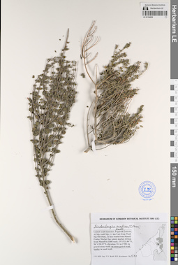
Collectors: Byalt, Vyacheslav Vyacheslavovich; Korshunov, Mikhail Vladimirovich Field collecting number: 1591. Collection date: 01.04.2020. Administrative regions: AE - United Arab Emirates. Place of collection: Fujairah Emirate, Al Siji, wadi Siji, 3.1 km East from Wadi Siji Old Dam, 3.6 km South from Masafi Friday Market Sur (plant market 4.8 km from Masafi by E88 road) [730]: on stone-gravel wadi banks, under gardens.Groups of specimens: Образцы общего сектора; Соглашение Минобрнауки №075-15-2021-1056; Бялт В.В.: Флора ФуджейрыOriginal label text: United Arab Emirates, Fujairah Emirate, Al Siji, wadi Siji, 3.1 km East from Wadi Siji Old Dam, 3.6 km South from Masafi Friday Market Sur (plant market 4.8 km from Masafi by E88 road). 25°15'33.84"N, 56° 6'30.33"E, elevation 314 m. [730]: on stone-gravel wadi banks, under gardens, 1 IV 2020, fr., V.V. Byalt, M.V. Korshunov 1591
LE 01194053
Lindenbergia arabica (S.Moore) Hartl det. Byalt, Vyacheslav Vyacheslavovich
Collectors: Melnikov, Denis Germanovich Field collecting number: 84. Collection date: 15.04.2022. Administrative regions: AE - United Arab Emirates. Place of collection: Emirate of Fujaira, Wadi Wurayah National Park, 8 km NW from Khor Fakkan, near waterfall and upper by the wadi [point 4]: on gravelly scree.Groups of specimens: Образцы общего сектора; Соглашение Минобрнауки №075-15-2021-1056; Бялт В.В.: Флора ФуджейрыOriginal label text: United Arab Emirates. Emirate of Fujaira, Wadi Wurayah National Park, 8 km NW from Khor Fakkan, 25°23, 366’ N, 56° 18, 356’ E, 165–220 m alt., near waterfall and upper by the wadi [point 4]: on gravelly scree, 15 IV 2022, fl., D.G. Melnikov 84
LE 01194062
Lindenbergia arabica (S.Moore) Hartl det. Byalt, Vyacheslav Vyacheslavovich
Collectors: Byalt, Vyacheslav Vyacheslavovich; Korshunov, Mikhail Vladimirovich Field collecting number: 1618a. Collection date: 01.04.2020. Administrative regions: AE - United Arab Emirates. Place of collection: Fujairah Emirate, Al Siji, wadi Siji, 3.1 km East from Wadi Siji Old Dam, 3.6 km South from Masafi Friday Market Sur (plant market 4.8 km from Masafi by E88 road) [730]: on stone-gravel wadi banks, under gardens.Groups of specimens: Образцы общего сектора; Соглашение Минобрнауки №075-15-2021-1056; Бялт В.В.: Флора ФуджейрыOriginal label text: United Arab Emirates, Fujairah Emirate, Al Siji, wadi Siji, 3.1 km East from Wadi Siji Old Dam, 3.6 km South from Masafi Friday Market Sur (plant market 4.8 km from Masafi by E88 road). 25°15'33.84"N, 56° 6'30.33"E, elevation 314 m. [730]: on stone-gravel wadi banks, under gardens, 1 IV 2020, fr., V.V. Byalt, M.V. Korshunov 1618a