View
Add
Copy
Edit
Delete
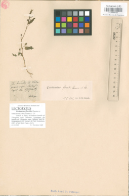
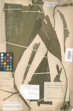
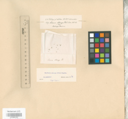
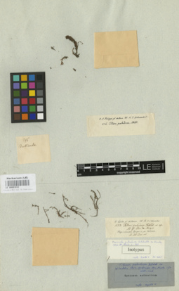
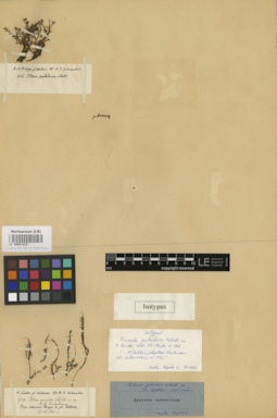
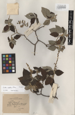
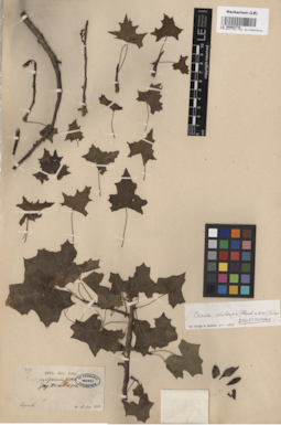
LE 00000155
Lectotype of Cardamine flaccida Chamisso et Schlechtendal
Place of collection: In humidis ad Talcaguano regni Chilensis.Groups of specimens: Образцы общего сектора; Типовые образцы Общего сектораComment:[Imported description]
Family: Brassicaceae
Taxon: Cardamine flaccida Chamisso et Schlechtendal
Type specimen category: Lectotype
Collectors: Eschscholtz
Locality: In humidis ad Talcaguano regni Chilensis
Family: Brassicaceae
Taxon: Cardamine flaccida Chamisso et Schlechtendal
Type specimen category: Lectotype
Collectors: Eschscholtz
Locality: In humidis ad Talcaguano regni Chilensis
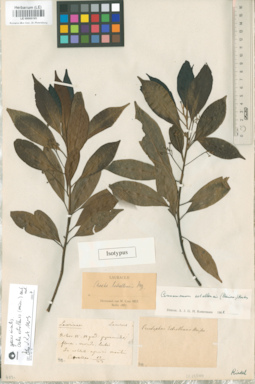
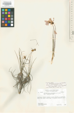
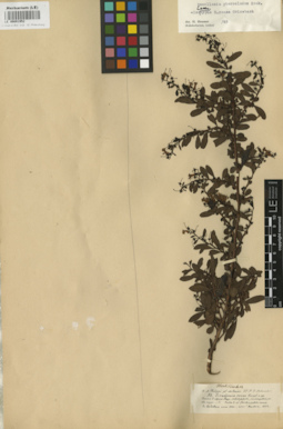
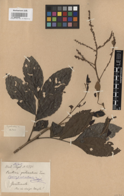
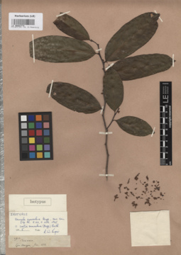
LE 00000195
Isotype of Oreodaphne estrellensis Meissn.
Collection date: 12.1823. Place of collection: In collib. apricis montis Estrellae.Groups of specimens: Образцы общего сектора; Типовые образцы Общего сектораComment:[Imported description]
Family: Lauraceae
Taxon: Oreodaphne estrellensis Meissn.
Type specimen category: Isotype
Collectors: [Riedel]
Collection date: 12.1823
Locality: In collib. apricis montis Estrellae
Family: Lauraceae
Taxon: Oreodaphne estrellensis Meissn.
Type specimen category: Isotype
Collectors: [Riedel]
Collection date: 12.1823
Locality: In collib. apricis montis Estrellae
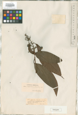
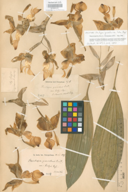
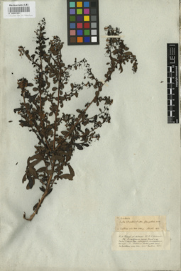
LE 00000224
Isotype of Nectandra barcellensis Meisn.
Field collecting number: 1926. Collection date: 12.1851. Administrative regions: BR - Brazil. Place of collection: Brasilia borealis, secus Rio negro, inter Barcellos et San Gabriel.Groups of specimens: Образцы общего сектора; Типовые образцы Общего сектораComment:[Imported description]
Family: Lauraceae
Taxon: Nectandra barcellensis Meisn.
Type specimen category: Isotype
Collectors: R. Spruce
Record number: 1926
Collection date: 12.1851
Country: Brazil
Locality: Brasilia borealis, secus Rio negro, inter Barcellos et San Gabriel
Family: Lauraceae
Taxon: Nectandra barcellensis Meisn.
Type specimen category: Isotype
Collectors: R. Spruce
Record number: 1926
Collection date: 12.1851
Country: Brazil
Locality: Brasilia borealis, secus Rio negro, inter Barcellos et San Gabriel
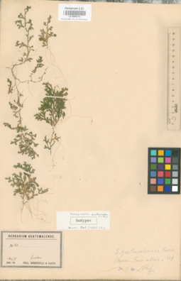
LE 00000310
Isotype of Selaginella guatemalensis Baker
Field collecting number: 162. Collection date: 08.1870. Place of collection: Herbarium Gyatemalense.Groups of specimens: Образцы общего сектора; Типовые образцы Общего сектораComment:[Imported description]
Family: Selaginellaceae
Taxon: Selaginella guatemalensis Baker
Type specimen category: Isotype
Collectors: Bernoulli et Cario
Record number: 162
Collection date: 08.1870
Locality: Herbarium Gyatemalense
Family: Selaginellaceae
Taxon: Selaginella guatemalensis Baker
Type specimen category: Isotype
Collectors: Bernoulli et Cario
Record number: 162
Collection date: 08.1870
Locality: Herbarium Gyatemalense
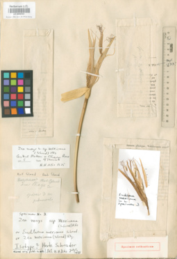
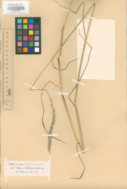
LE 00000361
Euchlaena mexicana Schrad.
Collection date: 12.08.1837. Place of collection: [Cult. In Horto Halensi].Groups of specimens: Образцы общего сектора; Типовые образцы Общего сектораComment:[Imported description]
Family: Poaceae
Taxon: Euchlaena mexicana Schrad.
Type specimen category: Original material vel Isotype ?
Collection date: 12.08.1837
Locality: [Cult. In Horto Halensi]
Family: Poaceae
Taxon: Euchlaena mexicana Schrad.
Type specimen category: Original material vel Isotype ?
Collection date: 12.08.1837
Locality: [Cult. In Horto Halensi]
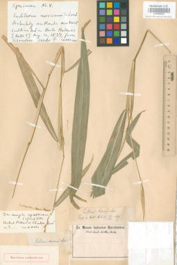
LE 00000362
Specimen originale of Euchlaena mexicana Schrad.
Collection date: 12.08.1837. Place of collection: Cult. In Horto Halensi.Groups of specimens: Образцы общего сектораComment:[Imported description]
Family: Poaceae
Taxon: Euchlaena mexicana Schrad.
Type specimen category: Original material
Collection date: 12.08.1837
Locality: Cult. In Horto Halensi
Family: Poaceae
Taxon: Euchlaena mexicana Schrad.
Type specimen category: Original material
Collection date: 12.08.1837
Locality: Cult. In Horto Halensi
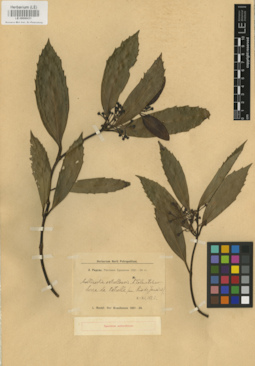
LE 00000429
Specimen originale of Mollinedia estrellensis Tolm.
Collection date: 10.1823. Administrative regions: BR - Brazil. Place of collection: Serra da Estrella (Pr. Rio de Janeiro).Groups of specimens: Образцы общего сектораComment:[Imported description]
Family: Monimiaceae
Taxon: Mollinedia estrellensis Tolm.
Type specimen category: Original material
Collectors: L. Riedel
Collection date: 10.1823
Country: Brazil
Locality: Serra da Estrella (Pr. Rio de Janeiro)
Family: Monimiaceae
Taxon: Mollinedia estrellensis Tolm.
Type specimen category: Original material
Collectors: L. Riedel
Collection date: 10.1823
Country: Brazil
Locality: Serra da Estrella (Pr. Rio de Janeiro)
LE 00000430
Specimen originale of Mollinedia estrellensis Tolm.
Collection date: 10.1823. Administrative regions: BR - Brazil. Place of collection: Serra da Estrella (Pr. Rio de Janeiro).Groups of specimens: Образцы общего сектораComment:[Imported description]
Family: Monimiaceae
Taxon: Mollinedia estrellensis Tolm.
Type specimen category: Original material
Collectors: L. Riedel
Collection date: 10.1823
Country: Brazil
Locality: Serra da Estrella (Pr. Rio de Janeiro)
Family: Monimiaceae
Taxon: Mollinedia estrellensis Tolm.
Type specimen category: Original material
Collectors: L. Riedel
Collection date: 10.1823
Country: Brazil
Locality: Serra da Estrella (Pr. Rio de Janeiro)
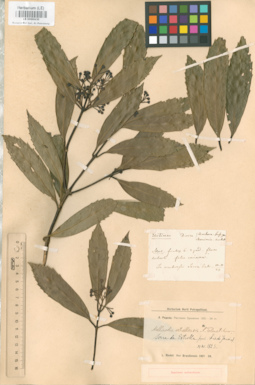
LE 00000431
Specimen originale of Mollinedia estrellensis Tolm.
Collection date: 10.1823. Administrative regions: BR - Brazil. Place of collection: Serra da Estrella (Pr. Rio de Janeiro).Groups of specimens: Образцы общего сектораComment:[Imported description]
Family: Monimiaceae
Taxon: Mollinedia estrellensis Tolm.
Type specimen category: Original material
Collectors: L. Riedel
Collection date: 10.1823
Country: Brazil
Locality: Serra da Estrella (Pr. Rio de Janeiro)
Family: Monimiaceae
Taxon: Mollinedia estrellensis Tolm.
Type specimen category: Original material
Collectors: L. Riedel
Collection date: 10.1823
Country: Brazil
Locality: Serra da Estrella (Pr. Rio de Janeiro)
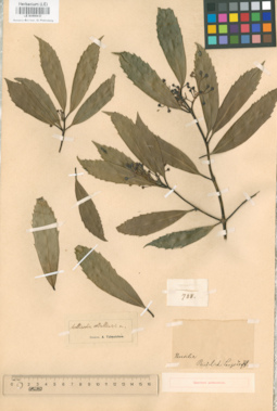
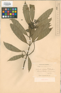
LE 00000432
Specimen originale of Mollinedia estrellensis Tolm.
Field collecting number: 788. Administrative regions: BR - Brazil. Groups of specimens: Образцы общего сектораComment:[Imported description]
Family: Monimiaceae
Taxon: Mollinedia estrellensis Tolm.
Type specimen category: Original material
Collectors: L. Riedel et Langsdorff
Record number: 788
Country: Brazil
Family: Monimiaceae
Taxon: Mollinedia estrellensis Tolm.
Type specimen category: Original material
Collectors: L. Riedel et Langsdorff
Record number: 788
Country: Brazil
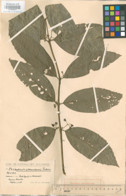
LE 00000433
Specimen originale of Mollinedia guatemalensis Perkins
Field collecting number: II 813. Collection date: 04.1913. Place of collection: dept. Alta Verapaz, 350 met. Culilguizim Worhovav. Kleiam Strauch..Groups of specimens: Образцы общего сектораComment:[Imported description]
Family: Monimiaceae
Taxon: Mollinedia guatemalensis Perkins
Type specimen category: Original material
Collectors: H. Türckheim
Record number: II 813
Collection date: 04.1913
Country: Guatemala
Locality: dept. Alta Verapaz, 350 met. Culilguizim Worhovav. Kleiam Strauch.
Altitude: 350 met
Family: Monimiaceae
Taxon: Mollinedia guatemalensis Perkins
Type specimen category: Original material
Collectors: H. Türckheim
Record number: II 813
Collection date: 04.1913
Country: Guatemala
Locality: dept. Alta Verapaz, 350 met. Culilguizim Worhovav. Kleiam Strauch.
Altitude: 350 met
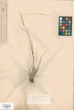
LE 00000637
Specimen originale of Stipa philippii Steud.
Field collecting number: 97. Collection date: 03.1852. Place of collection: Pl. chilenses, in pascuis ad Osorno frequens.Groups of specimens: Образцы общего сектораComment:[Imported description]
Family: Poaceae
Taxon: Stipa philippii Steud.
Type specimen category: Original material
Collectors: Philippi R.A.
Record number: 97
Collection date: 03.1852
Country: Chili
Locality: Pl. chilenses, in pascuis ad Osorno frequens
Family: Poaceae
Taxon: Stipa philippii Steud.
Type specimen category: Original material
Collectors: Philippi R.A.
Record number: 97
Collection date: 03.1852
Country: Chili
Locality: Pl. chilenses, in pascuis ad Osorno frequens
LE 00000638
Specimen originale of Stipa philippii Steud.
Field collecting number: 97. Collection date: 03.1852. Place of collection: Pl. chilenses, in pascuis ad Osorno frequens.Groups of specimens: Образцы общего сектораComment:[Imported description]
Family: Poaceae
Taxon: Stipa philippii Steud.
Type specimen category: Original material
Collectors: Philippi R.A.
Record number: 97
Collection date: 03.1852
Country: Chili
Locality: Pl. chilenses, in pascuis ad Osorno frequens
Family: Poaceae
Taxon: Stipa philippii Steud.
Type specimen category: Original material
Collectors: Philippi R.A.
Record number: 97
Collection date: 03.1852
Country: Chili
Locality: Pl. chilenses, in pascuis ad Osorno frequens
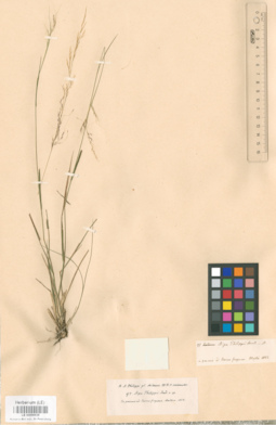
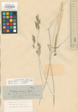
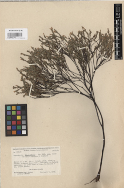
LE 00000644
Agrostis asperula Phil.
Field collecting number: 509. Place of collection: Pl. Chilens.,pr. Valdivia.Groups of specimens: Образцы общего сектора; Типовые образцы Общего сектораComment:[Imported description]
Family: Poaceae
Taxon: Agrostis asperula Phil.
Type specimen category: Cotype
Collectors: Philippi R.A.
Record number: 509
Country: Chili
Locality: Pl. Chilens.,pr. Valdivia
Family: Poaceae
Taxon: Agrostis asperula Phil.
Type specimen category: Cotype
Collectors: Philippi R.A.
Record number: 509
Country: Chili
Locality: Pl. Chilens.,pr. Valdivia
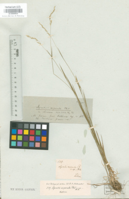
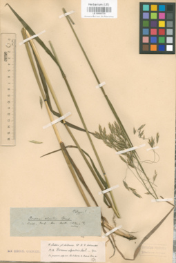
LE 00000651
Agrostis lechleri Steud.
Field collecting number: 410. Place of collection: Pl. chilenses. Ad margines viarum pr. Angachilla prov Valdivia.Groups of specimens: Образцы общего сектора; Типовые образцы Общего сектораComment:[Imported description]
Family: Poaceae
Taxon: Agrostis lechleri Steud.
Type specimen category: Cotype
Collectors: Lechler W.
Record number: 410
Country: Chili
Locality: Pl. chilenses. Ad margines viarum pr. Angachilla prov Valdivia
Family: Poaceae
Taxon: Agrostis lechleri Steud.
Type specimen category: Cotype
Collectors: Lechler W.
Record number: 410
Country: Chili
Locality: Pl. chilenses. Ad margines viarum pr. Angachilla prov Valdivia
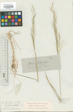
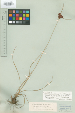
LE 00000673
Isotype of Relchela panicoides Steud.
Field collecting number: 435. Collection date: 12.1851. Place of collection: Pl. chilenses, prop ecol. Arique et pr. Techa.Groups of specimens: Образцы общего сектора; Типовые образцы Общего сектораComment:[Imported description]
Family: Poaceae
Taxon: Relchela panicoides Steud.
Type specimen category: Isotype
Collectors: Lechler W.
Record number: 435
Collection date: 12.1851
Country: Chili
Locality: Pl. chilenses, prop ecol. Arique et pr. Techa
Family: Poaceae
Taxon: Relchela panicoides Steud.
Type specimen category: Isotype
Collectors: Lechler W.
Record number: 435
Collection date: 12.1851
Country: Chili
Locality: Pl. chilenses, prop ecol. Arique et pr. Techa
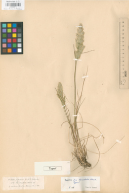
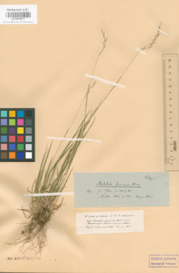
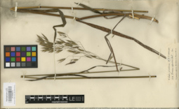
LE 00000714
Type of Poa denudata Steud.
Field collecting number: 578. Collection date: 11.1859. Place of collection: Pl. chilenses, in rupibus pr. Corral prov. Valdiviens.Groups of specimens: Образцы общего сектора; Типовые образцы Общего сектораComment:[Imported description]
Family: Poaceae
Taxon: Poa denudata Steud.
Type specimen category: Type
Collectors: Lechler W.
Record number: 578
Collection date: 11.1859
Country: Chili
Locality: Pl. chilenses, in rupibus pr. Corral prov. Valdiviens
Family: Poaceae
Taxon: Poa denudata Steud.
Type specimen category: Type
Collectors: Lechler W.
Record number: 578
Collection date: 11.1859
Country: Chili
Locality: Pl. chilenses, in rupibus pr. Corral prov. Valdiviens
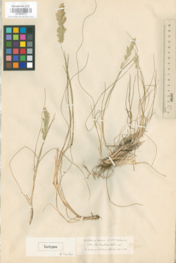
LE 00000715
Isotype of Poa denudata Steud.
Field collecting number: 578. Collection date: 11.1859. Place of collection: Pl. chilenses, in rupibus pr. Corral prov. Valdiviens.Groups of specimens: Образцы общего сектора; Типовые образцы Общего сектораComment:[Imported description]
Family: Poaceae
Taxon: Poa denudata Steud.
Type specimen category: Isotype
Collectors: Lechler W.
Record number: 578
Collection date: 11.1859
Country: Chili
Locality: Pl. chilenses, in rupibus pr. Corral prov. Valdiviens
Family: Poaceae
Taxon: Poa denudata Steud.
Type specimen category: Isotype
Collectors: Lechler W.
Record number: 578
Collection date: 11.1859
Country: Chili
Locality: Pl. chilenses, in rupibus pr. Corral prov. Valdiviens
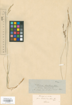
LE 00000730
Isotype of Festuca dumetorum Phil.
Field collecting number: 985a. Place of collection: Pl. chilens., Valdivia.Groups of specimens: Образцы общего сектора; Типовые образцы Общего сектораComment:[Imported description]
Family: Poaceae
Taxon: Festuca dumetorum Phil.
Type specimen category: Isotype
Collectors: Philippe
Record number: 985a
Country: Chili
Locality: Pl. chilens., Valdivia
Family: Poaceae
Taxon: Festuca dumetorum Phil.
Type specimen category: Isotype
Collectors: Philippe
Record number: 985a
Country: Chili
Locality: Pl. chilens., Valdivia
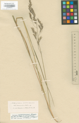
LE 00000737
Isotype of Festuca insularis M. Pop.
Field collecting number: 276. Collection date: 12.1850. Place of collection: Pl. chilenses, in insula Valenzuela pr. u. Valdivia. D. 1..Groups of specimens: Образцы общего сектора; Типовые образцы Общего сектораComment:[Imported description]
Family: Poaceae
Taxon: Festuca insularis Steud.
Type specimen category: Isotype
Collectors: Lechler W.
Record number: 276
Collection date: 12.1850
Country: Chili
Locality: Pl. chilenses, in insula Valenzuela pr. u. Valdivia. D. 1.
Family: Poaceae
Taxon: Festuca insularis Steud.
Type specimen category: Isotype
Collectors: Lechler W.
Record number: 276
Collection date: 12.1850
Country: Chili
Locality: Pl. chilenses, in insula Valenzuela pr. u. Valdivia. D. 1.
LE 00000738
Isotype of Festuca insularis M. Pop.
Field collecting number: 276. Collection date: 12.1850. Place of collection: Pl. chilenses, in insula Valenzuela pr. u. Valdivia. D. 1..Groups of specimens: Образцы общего сектора; Типовые образцы Общего сектораComment:[Imported description]
Family: Poaceae
Taxon: Festuca insularis Steud.
Type specimen category: Isotype
Collectors: Lechler W.
Record number: 276
Collection date: 12.1850
Country: Chili
Locality: Pl. chilenses, in insula Valenzuela pr. u. Valdivia. D. 1.
Family: Poaceae
Taxon: Festuca insularis Steud.
Type specimen category: Isotype
Collectors: Lechler W.
Record number: 276
Collection date: 12.1850
Country: Chili
Locality: Pl. chilenses, in insula Valenzuela pr. u. Valdivia. D. 1.
LE 00000750
Isotype of Bromus alpestris Steud.
Field collecting number: 1314. Place of collection: Pl. chilenses, in pascuis alpinis Cordillera de Ranes.Groups of specimens: Образцы общего сектора; Типовые образцы Общего сектораComment:[Imported description]
Family: Poaceae
Taxon: Bromus alpestris Steud.
Type specimen category: Isotype
Collectors: Lechler W.
Record number: 1314
Country: Chili
Locality: Pl. chilenses, in pascuis alpinis Cordillera de Ranes
Family: Poaceae
Taxon: Bromus alpestris Steud.
Type specimen category: Isotype
Collectors: Lechler W.
Record number: 1314
Country: Chili
Locality: Pl. chilenses, in pascuis alpinis Cordillera de Ranes
LE 00000751
Isotype of Bromus alpestris Steud.
Field collecting number: 1314. Place of collection: Pl. chilenses, in pascuis alpinis Cordillera de Ranes.Groups of specimens: Образцы общего сектора; Типовые образцы Общего сектораComment:[Imported description]
Family: Poaceae
Taxon: Bromus alpestris Steud.
Type specimen category: Isotype
Collectors: Lechler W.
Record number: 1314
Country: Chili
Locality: Pl. chilenses, in pascuis alpinis Cordillera de Ranes
Family: Poaceae
Taxon: Bromus alpestris Steud.
Type specimen category: Isotype
Collectors: Lechler W.
Record number: 1314
Country: Chili
Locality: Pl. chilenses, in pascuis alpinis Cordillera de Ranes
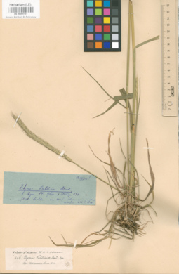
LE 00000761
Elymus valdiviae Steud.
Field collecting number: 446. Collection date: 11.1853. Place of collection: Pl. chilenses, Prov. Valdiviensis.Groups of specimens: Образцы общего сектора; Типовые образцы Общего сектораComment:[Imported description]
Family: Poaceae
Taxon: Elymus valdiviae Steud.
Type specimen category: Isotype?
Collectors: Lechler W.
Record number: 446
Collection date: 11.1853
Country: Chili
Locality: Pl. chilenses, Prov. Valdiviensis
Family: Poaceae
Taxon: Elymus valdiviae Steud.
Type specimen category: Isotype?
Collectors: Lechler W.
Record number: 446
Collection date: 11.1853
Country: Chili
Locality: Pl. chilenses, Prov. Valdiviensis
LE 00000762
Elymus valdiviae Steud.
Field collecting number: 446. Collection date: 11.1853. Place of collection: Pl. chilenses, Prov. Valdiviensis.Groups of specimens: Образцы общего сектора; Типовые образцы Общего сектораComment:[Imported description]
Family: Poaceae
Taxon: Elymus valdiviae Steud.
Type specimen category: Isotype?
Collectors: Lechler W.
Record number: 446
Collection date: 11.1853
Country: Chili
Locality: Pl. chilenses, Prov. Valdiviensis
Family: Poaceae
Taxon: Elymus valdiviae Steud.
Type specimen category: Isotype?
Collectors: Lechler W.
Record number: 446
Collection date: 11.1853
Country: Chili
Locality: Pl. chilenses, Prov. Valdiviensis
LE 00000778
Isotype of Cyperus haemostachys Steud.
Field collecting number: 283. Collection date: 11.1850. Place of collection: Pl. chilenses, in insula Valenzuella et pr. u. Valdivia.Groups of specimens: Образцы общего сектора; Типовые образцы Общего сектораComment:[Imported description]
Family: Cyperaceae
Taxon: Cyperus haemostachys Steud.
Type specimen category: Isotype
Collectors: Lechler W.
Record number: 283
Collection date: 11.1850
Country: Chili
Locality: Pl. chilenses, in insula Valenzuella et pr. u. Valdivia
Family: Cyperaceae
Taxon: Cyperus haemostachys Steud.
Type specimen category: Isotype
Collectors: Lechler W.
Record number: 283
Collection date: 11.1850
Country: Chili
Locality: Pl. chilenses, in insula Valenzuella et pr. u. Valdivia
LE 00000780
Isotype of Carex chlorolepis Steudel
Field collecting number: 309. Collection date: 11.1852. Place of collection: Pl. chilenses, prope San Juan in pascius.Groups of specimens: Образцы общего сектора; Типовые образцы Общего сектораComment:[Imported description]
Family: Cyperaceae
Taxon: Carex chlorolepis Steudel
Type specimen category: Isotype
Collectors: R.A. Philippe
Record number: 309
Collection date: 11.1852
Country: Chili
Locality: Pl. chilenses, prope San Juan in pascius
Family: Cyperaceae
Taxon: Carex chlorolepis Steudel
Type specimen category: Isotype
Collectors: R.A. Philippe
Record number: 309
Collection date: 11.1852
Country: Chili
Locality: Pl. chilenses, prope San Juan in pascius
LE 00000790
Isolectotype of Carex trichodes Steudel ex Boott
Field collecting number: 3055. Collection date: 12.1868. Place of collection: Pl. chilenses, ad scaturigines Sichahue Cordiller. de Ranco..Groups of specimens: Образцы общего сектора; Типовые образцы Общего сектораComment:[Imported description]
Family: Cyperaceae
Taxon: Carex trichodes Steudel ex Boott
Type specimen category: Isolectotype
Collectors: Lechler W.
Record number: 3055
Collection date: 12.1868
Country: Chili
Locality: Pl. chilenses, ad scaturigines Sichahue Cordiller. de Ranco.
Family: Cyperaceae
Taxon: Carex trichodes Steudel ex Boott
Type specimen category: Isolectotype
Collectors: Lechler W.
Record number: 3055
Collection date: 12.1868
Country: Chili
Locality: Pl. chilenses, ad scaturigines Sichahue Cordiller. de Ranco.
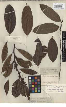
LE 00000960
Isolectotype of Carludovica brachypus Drude
Field collecting number: 1. Collection date: 1831. Place of collection: Iter Brasillense.Groups of specimens: Образцы общего сектора; Типовые образцы Общего сектораComment:[Imported description]
Family: Cyclanthaceae
Taxon: Carludovica brachypus Drude
Type specimen category: Isolectotype
Collectors: I. Regel et B. Luschnath
Record number: 1
Collection date: 1831
Country: [Brazil]
Locality: Iter Brasillense
Family: Cyclanthaceae
Taxon: Carludovica brachypus Drude
Type specimen category: Isolectotype
Collectors: I. Regel et B. Luschnath
Record number: 1
Collection date: 1831
Country: [Brazil]
Locality: Iter Brasillense
LE 00001025
Syntype of Lemna oblonga Phil.
Field collecting number: 729. Collection date: 1859. Place of collection: Pl. chilens., Santiago.Groups of specimens: Образцы общего сектора; Типовые образцы Общего сектораComment:[Imported description]
Family: Lemnaceae
Taxon: Lemna oblonga Phil.
Type specimen category: Syntype
Collectors: Philippi R.A.
Record number: 729
Collection date: 05.[1859]
Country: Chili
Locality: Pl. chilens., Santiago
Family: Lemnaceae
Taxon: Lemna oblonga Phil.
Type specimen category: Syntype
Collectors: Philippi R.A.
Record number: 729
Collection date: 05.[1859]
Country: Chili
Locality: Pl. chilens., Santiago
LE 00001261
Isotype of Vellozia grao-mogulensis L.B. Sm.
Field collecting number: 49216. Collection date: 16.08.1960. Administrative regions: BR - Brazil. Place of collection: Serra Grao Mogul, north base of mountain, 600-700 m. alt..Groups of specimens: Образцы общего сектора; Типовые образцы Общего сектораComment:[Imported description]
Family: Velloziaceae
Taxon: Vellozia grao-mogulensis L.B. Sm.
Type specimen category: Isotype
Collectors: B. Maguire, G.M.Megalhaes,C.K.Maguire
Record number: 49216
Collection date: 16.08.1960
Country: Brazil
Locality: Serra Grao Mogul, north base of mountain, 600-700 m. alt.
Altitude: 600-700 m. alt.
LE 00001451
Holotype of Stanhopea graveolens var. lietzei Regel
Field collecting number: 87.6. Collection date: 16.06.1887. Groups of specimens: Образцы общего сектора; Типовые образцы Общего сектораComment:[Imported description]
Family: Orchidaceae
Taxon: Stanhopea graveolens var. lietzei Regel
Type specimen category: Holotype
Collectors: Ex horto bot. Petropolitano
Record number: 87.6
Collection date: 16.06.1887
Country: Brazil,Cult.in Hort bot. Petropolitano
Family: Orchidaceae
Taxon: Stanhopea graveolens var. lietzei Regel
Type specimen category: Holotype
Collectors: Ex horto bot. Petropolitano
Record number: 87.6
Collection date: 16.06.1887
Country: Brazil,Cult.in Hort bot. Petropolitano
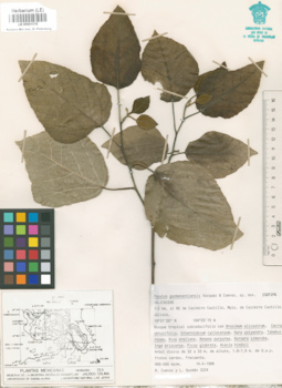
LE 00001518
Isotype of Populus guzmanantlensis A.Vázquez et Cuevas
Field collecting number: 3224. Collection date: 14.10.1988. Place of collection: 1-2 km. al NE de Casimiro Castillo.Groups of specimens: Образцы общего сектора; Типовые образцы Общего сектораComment:[Imported description]
Family: Salicaceae
Taxon: Populus guzmanantlensis A.Vázquez et Cuevas
Type specimen category: Isotype
Collectors: R.Cuevas, L. Guzmán
Record number: 3224
Collection date: 14.10.1988
Country: Mexico
Locality: 1-2 km. al NE de Casimiro Castillo
Altitude: 400-500 m.
Family: Salicaceae
Taxon: Populus guzmanantlensis A.Vázquez et Cuevas
Type specimen category: Isotype
Collectors: R.Cuevas, L. Guzmán
Record number: 3224
Collection date: 14.10.1988
Country: Mexico
Locality: 1-2 km. al NE de Casimiro Castillo
Altitude: 400-500 m.
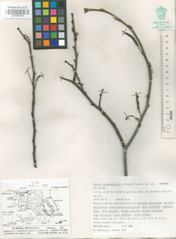
LE 00001519
Isotype of Populus guzmanantlensis A.Vázquez et Cuevas
Field collecting number: 3224. Collection date: 14.10.1988. Place of collection: 1-2 km. al NE de Casimiro Castillo.Groups of specimens: Образцы общего сектора; Типовые образцы Общего сектораComment:[Imported description]
Family: Salicaceae
Taxon: Populus guzmanantlensis A.Vázquez et Cuevas
Type specimen category: Isotype
Collectors: R.Cuevas, L. Guzmán
Record number: 3224
Collection date: 14.10.1988
Country: Mexico
Locality: 1-2 km. al NE de Casimiro Castillo
Altitude: 400-500m.
Family: Salicaceae
Taxon: Populus guzmanantlensis A.Vázquez et Cuevas
Type specimen category: Isotype
Collectors: R.Cuevas, L. Guzmán
Record number: 3224
Collection date: 14.10.1988
Country: Mexico
Locality: 1-2 km. al NE de Casimiro Castillo
Altitude: 400-500m.
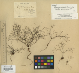
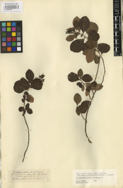
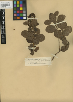
LE 00001650
Isotype of Brisegnoa chilensis J.Rèmy
Field collecting number: 584. Administrative regions: CL - Chile. Groups of specimens: Образцы общего сектора; Типовые образцы Общего сектораComment:[Imported description]
Family: Polygonaceae
Taxon: Brisegnoa chilensis J.Rèmy
Type specimen category: Isotype
Collectors: M.Cl.Gay
Record number: 584
Country: Chile
Family: Polygonaceae
Taxon: Brisegnoa chilensis J.Rèmy
Type specimen category: Isotype
Collectors: M.Cl.Gay
Record number: 584
Country: Chile
LE 00001897
Specimen originale of Gynandropsis densiflora β pallens Linden et Planch.
Field collecting number: 1734. Collection date: 1848. Place of collection: N. Grenade, prov. Bampilona, l. Boja.Groups of specimens: Образцы общего сектораComment:[Imported description]
Family: Capparaceae
Taxon: Gynandropsis densiflora β pallens Linden et Planch.
Type specimen category: Original material
Collectors: L. Schlim
Record number: 1734
Collection date: 1848
Locality: N. Grenade, prov. Bampilona, l. Boja
Altitude: 9000 p.
Family: Capparaceae
Taxon: Gynandropsis densiflora β pallens Linden et Planch.
Type specimen category: Original material
Collectors: L. Schlim
Record number: 1734
Collection date: 1848
Locality: N. Grenade, prov. Bampilona, l. Boja
Altitude: 9000 p.
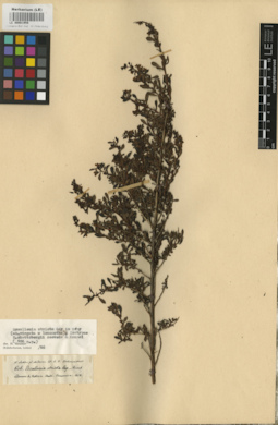
LE 00001932
Isotype of Crassula paludosa Schlect. ex Reiche
Field collecting number: 472. Administrative regions: CL - Chile. Place of collection: Pl. chilenses. Prope coloniam Arique in pr. Valdivia. Ad fl. Rio de Arique.Groups of specimens: Образцы общего сектора; Типовые образцы Общего сектораComment:[Imported description]
Family: Crassulaceae
Taxon: Crassula paludosa Schlect. ex Reiche
Type specimen category: Isotype
Collectors: W. Lechler
Record number: 472
Country: Chile
Locality: Pl. chilenses. Prope coloniam Arique in pr. Valdivia. Ad fl. Rio de Arique
Family: Crassulaceae
Taxon: Crassula paludosa Schlect. ex Reiche
Type specimen category: Isotype
Collectors: W. Lechler
Record number: 472
Country: Chile
Locality: Pl. chilenses. Prope coloniam Arique in pr. Valdivia. Ad fl. Rio de Arique
LE 00001933
Isotype of Crassula paludosa Schlect. ex Reiche
Field collecting number: 472. Administrative regions: CL - Chile. Place of collection: Pl. chilenses. Prope coloniam Arique in pr. Valdivia. Ad fl. Rio de Arique.Groups of specimens: Образцы общего сектора; Типовые образцы Общего сектораComment:[Imported description]
Family: Crassulaceae
Taxon: Crassula paludosa Schlect. ex Reiche
Type specimen category: Isotype
Collectors: W. Lechler
Record number: 472
Country: Chile
Locality: Pl. chilenses. Prope coloniam Arique in pr. Valdivia. Ad fl. Rio de Arique
Family: Crassulaceae
Taxon: Crassula paludosa Schlect. ex Reiche
Type specimen category: Isotype
Collectors: W. Lechler
Record number: 472
Country: Chile
Locality: Pl. chilenses. Prope coloniam Arique in pr. Valdivia. Ad fl. Rio de Arique
LE 00001952
Isolectotype of Escallonia rosea Griseb.
Field collecting number: 54. Collection date: 03.1852. Administrative regions: CL - Chile. Place of collection: Pl. chilenses. In Corillera.Groups of specimens: Образцы общего сектора; Типовые образцы Общего сектораComment:[Imported description]
Family: Escalloniaceae
Taxon: Escallonia rosea Grisebach
Type specimen category: Isolectotype
Collectors: R. A. Philippi
Record number: 54
Collection date: 03.1852
Country: Chile
Locality: Pl. chilenses. In Corillera
Altitude: circa 3000-3500'
Family: Escalloniaceae
Taxon: Escallonia rosea Grisebach
Type specimen category: Isolectotype
Collectors: R. A. Philippi
Record number: 54
Collection date: 03.1852
Country: Chile
Locality: Pl. chilenses. In Corillera
Altitude: circa 3000-3500'
LE 00001953
Isolectotype of Escallonia rosea Griseb.
Field collecting number: 54. Collection date: 03.1852. Administrative regions: CL - Chile. Place of collection: Pl. chilenses. In Corillera.Groups of specimens: Образцы общего сектора; Типовые образцы Общего сектораComment:[Imported description]
Family: Escalloniaceae
Taxon: Escallonia rosea Grisebach
Type specimen category: Isolectotype
Collectors: R. A. Philippi
Record number: 54
Collection date: 03.1852
Country: Chile
Locality: Pl. chilenses. In Corillera
Altitude: circa 3000-3500'
Family: Escalloniaceae
Taxon: Escallonia rosea Grisebach
Type specimen category: Isolectotype
Collectors: R. A. Philippi
Record number: 54
Collection date: 03.1852
Country: Chile
Locality: Pl. chilenses. In Corillera
Altitude: circa 3000-3500'
LE 00001955
Escallonia dumetorum Phil. ex Phil. et Griseb.
Field collecting number: 862. Administrative regions: CL - Chile. Place of collection: Pl. chilenses. Pr. S. Juan in pr. Valdiviensi in dumetis.Groups of specimens: Образцы общего сектора; Типовые образцы Общего сектораComment:[Imported description]
Family: Escalloniaceae
Taxon: Escallonia dumetorum Phil. ex Phil. et Griseb.
Type specimen category: Isotype ?
Collectors: R. A. Philippi
Record number: 862
Country: Chile
Locality: Pl. chilenses. Pr. S. Juan in pr. Valdiviensi in dumetis
Family: Escalloniaceae
Taxon: Escallonia dumetorum Phil. ex Phil. et Griseb.
Type specimen category: Isotype ?
Collectors: R. A. Philippi
Record number: 862
Country: Chile
Locality: Pl. chilenses. Pr. S. Juan in pr. Valdiviensi in dumetis
LE 00001956
Specimen originale of Escallonia dumetorum Phil. ex Phil. et Griseb.
Field collecting number: 862. Administrative regions: CL - Chile. Place of collection: Pl. chilenses. Pr. S. Juan in pr. Valdiviensi in dumetis.Groups of specimens: Образцы общего сектораComment:[Imported description]
Family: Escalloniaceae
Taxon: Escallonia dumetorum Phil. ex Phil. et Griseb.
Type specimen category: Original material
Collectors: R. A. Philippi
Record number: 862
Country: Chile
Locality: Pl. chilenses. Pr. S. Juan in pr. Valdiviensi in dumetis
Family: Escalloniaceae
Taxon: Escallonia dumetorum Phil. ex Phil. et Griseb.
Type specimen category: Original material
Collectors: R. A. Philippi
Record number: 862
Country: Chile
Locality: Pl. chilenses. Pr. S. Juan in pr. Valdiviensi in dumetis
LE 00001959
Isotype of Escallonia skottsbergii Acevedo et Kausel
Field collecting number: 606. Collection date: 01.1852. Administrative regions: CL - Chile. Place of collection: Pl. chilenses. Llannos de Valdivia. Huiti.Groups of specimens: Образцы общего сектора; Типовые образцы Общего сектораComment:[Imported description]
Family: Escalloniaceae
Taxon: Escallonia skottsbergii Acevedo et Kausel
Type specimen category: Isotype
Collectors: W. Lechler
Record number: 606
Collection date: 01.1852
Country: Chile
Locality: Pl. chilenses. Llannos de Valdivia. Huiti
Family: Escalloniaceae
Taxon: Escallonia skottsbergii Acevedo et Kausel
Type specimen category: Isotype
Collectors: W. Lechler
Record number: 606
Collection date: 01.1852
Country: Chile
Locality: Pl. chilenses. Llannos de Valdivia. Huiti
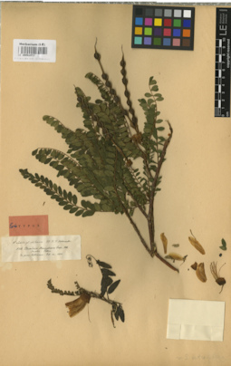
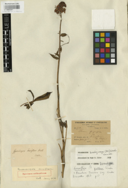
LE 00002472
Lectotype of Edwardsia macnabiana Graham
Field collecting number: 536. Collection date: 10.1850. Administrative regions: CL - Chile. Place of collection: Pl. Chilenses, in prov. Valdiviensi.Groups of specimens: Образцы общего сектора; Типовые образцы Общего сектораComment:[Imported description]
Family: Fabaceae
Taxon: Edwardsia macnabiana Graham
Type specimen category: Lectotype
Collectors: W. Lechler
Record number: 536
Collection date: 10.1850
Country: Chile
Locality: Pl. Chilenses, in prov. Valdiviensi
Family: Fabaceae
Taxon: Edwardsia macnabiana Graham
Type specimen category: Lectotype
Collectors: W. Lechler
Record number: 536
Collection date: 10.1850
Country: Chile
Locality: Pl. Chilenses, in prov. Valdiviensi
LE 00003132
Isotype of Croton redolens Pittier
Field collecting number: 11886. Collection date: 06.09.1925. Administrative regions: VE - Venezuela (Bolivarian Republic of). Place of collection: Near Las Trincheras, 900 m; road Caracas-La Guayva, in xerophytic formation.Groups of specimens: Образцы общего сектора; Типовые образцы Общего сектораComment:[Imported description]
Family: Euphorbiaceae
Taxon: Croton redolens Pittier
Type specimen category: Isotypus
Identified by: Pittier
Collectors: H. Pittier
Record number: 11886
Collection date: 06.09.1925
Country: Venezuela
Locality: Near Las Trincheras, 900 m; road Caracas-La Guayva, in xerophytic formation
Family: Euphorbiaceae
Taxon: Croton redolens Pittier
Type specimen category: Isotypus
Identified by: Pittier
Collectors: H. Pittier
Record number: 11886
Collection date: 06.09.1925
Country: Venezuela
Locality: Near Las Trincheras, 900 m; road Caracas-La Guayva, in xerophytic formation
LE 00003520
Specimen originale of Cupania guatemalensis Radlk.
Field collecting number: 12771. Place of collection: Guatemala.Groups of specimens: Образцы общего сектораComment:[Imported description]
Family: Sapindaceae
Taxon: Cupania guatemalensis Radlk.
Type specimen category: Original material
Identified by: Radlk.
Collectors: Herb. Kegel
Record number: 12771
Country: Guatemala
Locality: Guatemala
Family: Sapindaceae
Taxon: Cupania guatemalensis Radlk.
Type specimen category: Original material
Identified by: Radlk.
Collectors: Herb. Kegel
Record number: 12771
Country: Guatemala
Locality: Guatemala
LE 00003728
Isotype of Sauvagesia linearifolia subsp. venezuelensis Maguire et Wurdack
Field collecting number: 37625. Collection date: 09.01.1954. Administrative regions: VE - Venezuela (Bolivarian Republic of). Place of collection: Rio Siapa, Casiquiare, Territorio de Amazonas. Frequent in Sabana Hechimoni on left bank of Cano Hechimoni 8 km. above mouth..Groups of specimens: Образцы общего сектора; Типовые образцы Общего сектораComment:[Imported description]
Family: Ochnaceae
Taxon: Sauvagesia linearifolia subsp. venezuelensis Maguire et Wurdack
Type specimen category: Isotypus
Identified by: Maguire et Wurdack
Collectors: B. Maguire, J.J. Wurdack, G.S. Bunting
Record number: 37625
Collection date: 09.01.1954
Country: Venezuela
Locality: Rio Siapa, Casiquiare, Territorio de Amazonas. Frequent in Sabana Hechimoni on left bank of Cano Hechimoni 8 km. above mouth.
Altitude: 100-130 m
LE 00003773
Isotype of Samyda suaveolens Poepp. et Endl.
Field collecting number: 2912. Place of collection: Amazonas.Groups of specimens: Образцы общего сектора; Типовые образцы Общего сектораComment:[Imported description]
Family: Flacourtiaceae
Taxon: Samyda suaveolens Poepp. et Endl.
Type specimen category: Isotypus
Identified by: Poepp. et Endl.
Collectors: Pöppig
Record number: 2912
Country: [Brazil]
Locality: Amazonas
Family: Flacourtiaceae
Taxon: Samyda suaveolens Poepp. et Endl.
Type specimen category: Isotypus
Identified by: Poepp. et Endl.
Collectors: Pöppig
Record number: 2912
Country: [Brazil]
Locality: Amazonas
LE 00003774
Isotype of Samyda suaveolens Poepp. et Endl.
Field collecting number: 2912. Place of collection: Ega, Amazonas.Groups of specimens: Образцы общего сектора; Типовые образцы Общего сектораComment:[Imported description]
Family: Flacourtiaceae
Taxon: Samyda suaveolens Poepp. et Endl.
Type specimen category: Isotypus
Identified by: Poepp. et Endl.
Collectors: Pöppig
Record number: 2912
Collection date: 01.[1]832
Country: [Brazil]
Locality: Ega, Amazonas
Family: Flacourtiaceae
Taxon: Samyda suaveolens Poepp. et Endl.
Type specimen category: Isotypus
Identified by: Poepp. et Endl.
Collectors: Pöppig
Record number: 2912
Collection date: 01.[1]832
Country: [Brazil]
Locality: Ega, Amazonas
LE 00003778
Isolectotype of Vasconcellea chilensis Planch.
Collection date: 1838. Place of collection: Coquimbo.Groups of specimens: Образцы общего сектора; Типовые образцы Общего сектораComment:[Imported description]
Family: Caricaceae
Taxon: Vasconcellea chilensis Planch.
Type specimen category: Isolectotypus
Identified by: Planch.
Collectors: Cl. Gay
Collection date: 1838
Country: [Chile]
Locality: Coquimbo
Family: Caricaceae
Taxon: Vasconcellea chilensis Planch.
Type specimen category: Isolectotypus
Identified by: Planch.
Collectors: Cl. Gay
Collection date: 1838
Country: [Chile]
Locality: Coquimbo