View
Add
Copy
Edit
Delete
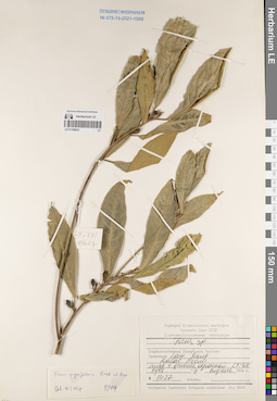
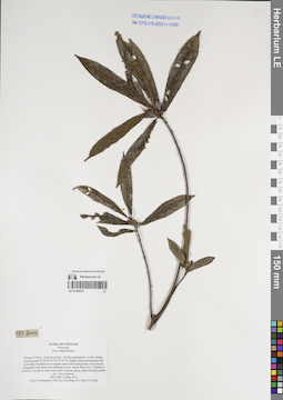
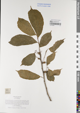
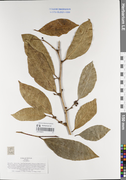
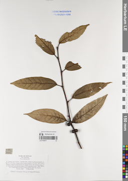
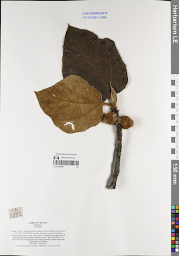
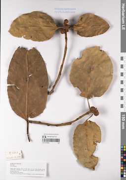
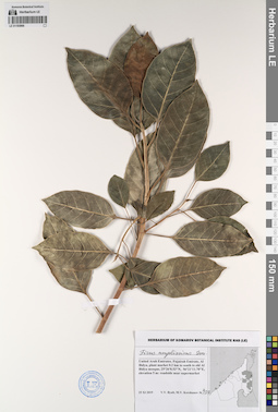
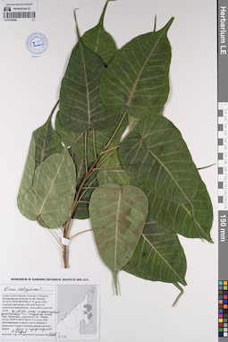
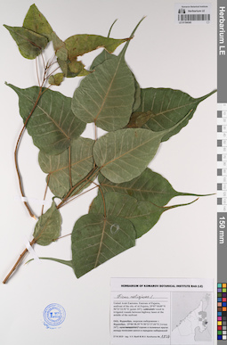
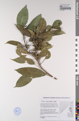
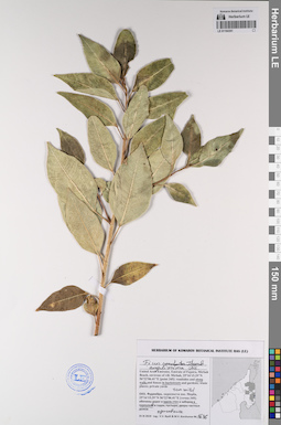
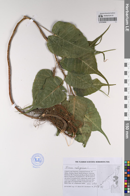
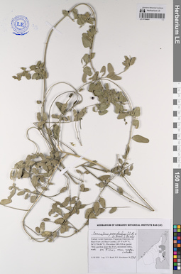
LE 01168832
Ficus pyriformis Hook. & Arn. det. Tien Hiep Nguyen at 08.1997
Collectors: Unknown Field collecting number: LX-VN 1427. Collection date: 11.04.1984. Administrative regions: VN - Tinh Lam GJong. Groups of specimens: L. V. Averyanov specimens; L. V. Averyanov herbarium; Соглашение Минобрнауки №075-15-2021-1056Original label text:FLORA VIETNAMICA
Record creation: 2022-07-07, Galina Savich, PhotoScan D2.. Processing status: work_status_1Citation: Specimen LE 01168832 // Virtual herbarium of Komarov Botanical Institute RAS — http://re.herbariumle.ru/01168832Moraceae
Ficus pyriformis Hook. & Arn.
Lam Dong Prov.
11.04.1984, LX-VN 1427
Det. Tien Hiep Nguyen at 08.1997
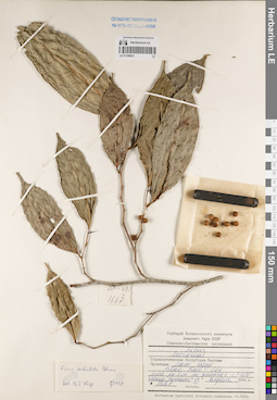
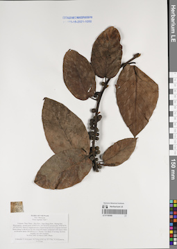
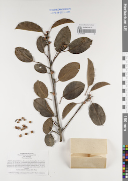
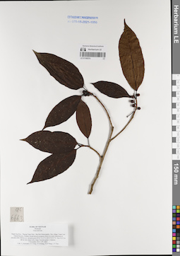
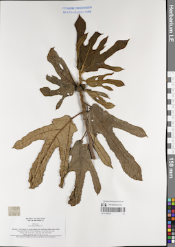
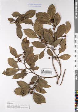
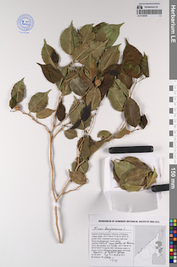
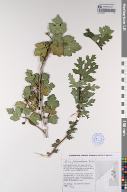
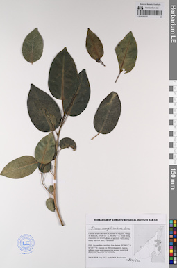
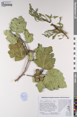
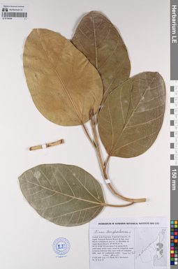
LE 01168833
Ficus subulata Blume. det. Tien Hiep Nguyen at 08.1997
Collectors: Unknown Field collecting number: LX-VN 1667. Collection date: 18.04.1984. Administrative regions: VN - Tinh Lam GJong. Groups of specimens: L. V. Averyanov specimens; L. V. Averyanov herbarium; Соглашение Минобрнауки №075-15-2021-1056Original label text:FLORA VIETNAMICA
Moraceae
Ficus subulata Blume.
Lam Dong Prov.
18.04.1984, LX-VN 1667.
Det. Tien Hiep Nguyen at 08.1997
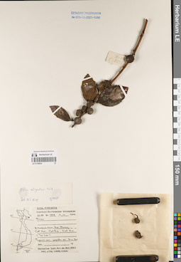
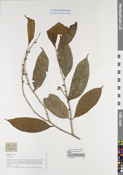
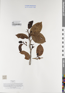
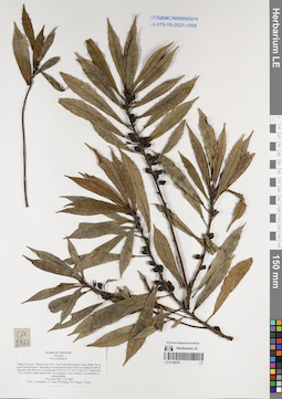
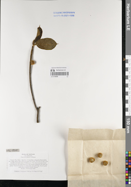
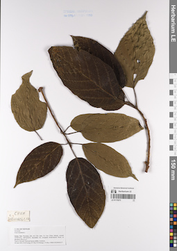
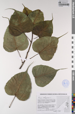
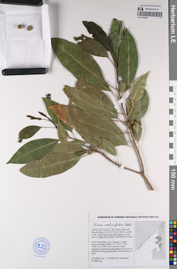
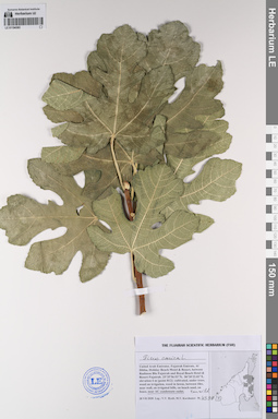
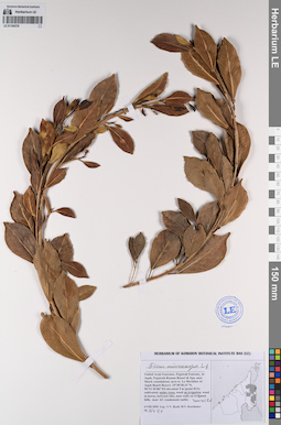
LE 01168834
Ficus oligodon Miq. det. Tien Hiep Nguyen at 08.1997
Collectors: Unknown Field collecting number: LX-VN 3818. Collection date: 11.01.1988. Administrative regions: VN - Thanh Pho Hai Phong. Groups of specimens: L. V. Averyanov specimens; L. V. Averyanov herbarium; Соглашение Минобрнауки №075-15-2021-1056Original label text:FLORA VIETNAMICA
Record creation: 2022-07-07, Galina Savich, PhotoScan D2.. Processing status: work_status_1Citation: Specimen LE 01168834 // Virtual herbarium of Komarov Botanical Institute RAS — http://re.herbariumle.ru/01168834Moraceae
Ficus oligodon Miq.
Hai Phong Prov.
11.01.1988, LX-VN 3818
Det. Tien Hiep Nguyen at 08.1997
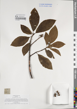
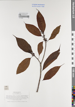
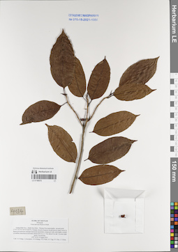
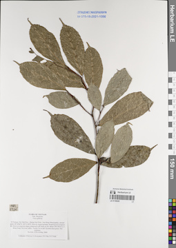
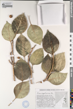
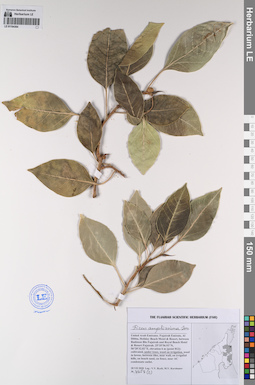
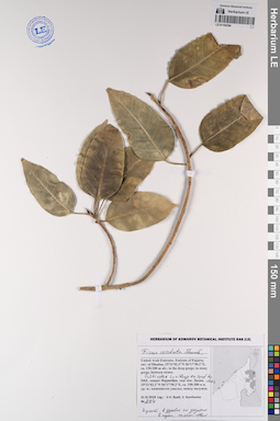
LE 01169355
Ficus chartacea (Wall. ex Kurz) Wall. ex King det. Averyanov, Leonid Vladimirovich at 06.08.2011
Collectors: Averyanov, Leonid Vladimirovich; et al. Field collecting number: CPC4082. Collection date: 06.08.2011. Administrative regions: VN - Tinh Quang Binh. Groups of specimens: L. V. Averyanov specimens; L. V. Averyanov herbarium; Соглашение Минобрнауки №075-15-2021-1056Original label text:FLORA OF VIETNAM
Moraceae
Ficus chartacea Wall. ex King
Quang Binh Prov., Minh Hoa Distr., Thuong Hoa municipality, around point 17°41’14.3”N 105°53’28.9”E. Primary short evergreen broad-leaved mossy forest on tops and along ridge edge composed with solid crystalline limestone at elevation 700-750 m a.s.l. Treelet about 4 m tall. Syconia yellowish-green, sometime with purple tint. Not common.
CPC 4082 6 August 2011
Coll.: N.T.Hiep, L.Averyanov, N.S.Khang, N.Q.Vinh, N.V.Tap, P.V.The, L.T.Kien.
LE 01169357
Ficus subpyriformis det. Averyanov, Leonid Vladimirovich at 10.05.2011
Collectors: Averyanov, Leonid Vladimirovich; et al. Field collecting number: CPC3000. Collection date: 10.05.2011. Administrative regions: VN - Tinh Quang Tri. Groups of specimens: L. V. Averyanov specimens; L. V. Averyanov herbarium; Соглашение Минобрнауки №075-15-2021-1056Original label text:FLORA OF VIETNAM
Moraceae
Ficus subpyriformis
Quang Tri Prov., Da Krong Distr., Ta Rut municipality, A Pul village, around point 16°24’29”N 107°01’07”E. Highly destroyed primary and secondary broadleaved evergreen open forest along rocky river canyon composed with shale and sandstone at elev. about 300 m a.s.l. Treelet or shrub to 3 m tall on open river rocks. Syconia green, often wit dirty purple tint. Very common.
CPC 3000 10 May 2011
Coll.: L.Averyanov, P.K.Loc, N.Q.Hieu, P.V.The, N.T.Vinh.
LE 01169360
Ficus sagittata Vahl det. Averyanov, Leonid Vladimirovich at 26.03.2005
Collectors: Averyanov, Leonid Vladimirovich; et al. Field collecting number: HAL6963. Collection date: 26.03.2005. Administrative regions: VN - Tinh Thua Thien-Hue. Groups of specimens: L. V. Averyanov specimens; L. V. Averyanov herbarium; Соглашение Минобрнауки №075-15-2021-1056Original label text:FLORA OF VIETNAM
Fam. Moraceae
Ficus sagittata Vahl ?
Vietnam, Thua Thien – Hue Prov., Nam Dong Distr., Huong Son Municipality, around point 16°09'52''N, 107°36'22''E (around plot 16°09'36''N, 107°36'10''E). Heavily logged primary closed broad-leaved evergreen lowland forest along La Ma River on very steep hill slopes composed with clayey shale at elevation about 300-450 m a.s.l. Woody vine about 10 m long. Syconia brightly red. Not common.
No HAL 6963 26 March 2005. Photo.
Collectors: L.Averyanov, N.T.Hiep, P.K.Loc, P.V.The, A.Averyanova, N.T.Vinh.
LE 01169363
Ficus tinctoria Forst.f. det. Averyanov, Leonid Vladimirovich at 11.04.2015
Collectors: Averyanov, Leonid Vladimirovich; et al. Field collecting number: LA-VN1354. Collection date: 11.04.2015. Administrative regions: LA - Houaphan. Groups of specimens: L. V. Averyanov specimens; L. V. Averyanov herbarium; Соглашение Минобрнауки №075-15-2021-1056Original label text:FLORA OF LAOS
Moraceae
Ficus tinctoria?
Houphan Prov., Hem Distr., Na Puok village, Pu Tham Nhon mountain around point 20°10'00.0''N 103°24'37.0''E. Primary and secondary broad-leaved evergreen dry forest on very steep rocky mountain slopes composed by solid marble-like highly eroded limestone at elev. 1050-1150 m a.s.l. Treelet 5-6 m tall. Syconia light green. Common.
LA-VN 1354 11 April 2015
Coll.: N.T.Hiep, L.Averyanov, N.S.Khang, N.Q.Hieu, T.Maisak, Pheng Phengsintham.
LE 01169364
Ficus nervosa Roth det. Averyanov, Leonid Vladimirovich at 22.04.2005
Collectors: Averyanov, Leonid Vladimirovich; et al. Field collecting number: HAL7363. Collection date: 22.04.2005. Administrative regions: VN - Tinh Thua Thien-Hue. Groups of specimens: L. V. Averyanov specimens; L. V. Averyanov herbarium; Соглашение Минобрнауки №075-15-2021-1056Original label text:FLORA OF VIETNAM
Fam. Moraceae
Ficus nervosa Heyne ex Roth
Vietnam, Thua Thien – Hue Prov., A Luoi Distr., A Roang Municipality, Tra Lenh Forestry Department station, around point 16°04'41''N, 107°29'06''E. Primary closed evergreen broad-leaved forest on very steep mountain slopes composed with shale, sandstone and granite at elevation 700-800 m a.s.l. Tree 6-10 m tall along rocky stream valley. Syconia green. Occasional.
No HAL 7363 22 April 2005.
Collectors: L.Averyanov, P.K.Loc, J.Regalado, T.V.Thao, N.T.Vinh.
LE 01169365
Ficus ceratophylla det. Averyanov, Leonid Vladimirovich at 22.05.2004
Collectors: Averyanov, Leonid Vladimirovich; et al. Field collecting number: HAL4774. Collection date: 22.05.2004. Administrative regions: VN - Tinh Bac Kan. Groups of specimens: L. V. Averyanov specimens; L. V. Averyanov herbarium; Соглашение Минобрнауки №075-15-2021-1056Original label text:FLORA OF VIETNAM
Fam. Moraceae
Ficus ceratophylla
N.Vietnam, Bac Kan Prov., Cho Don Distr., Ban Thi Municipality, village Phia Khao, around point 22є16'10''N, 105є31'01''E at elevation 700-850 m a.s.l. (Tang Gia mountain). Primary broad-leaved evergreen closed forest on very steep slopes and cliffs near and on tops of rocky ridge composed with solid marble-like stratified limestone. Treelet about 5 m tall. Syconia dull green. Occasional.
No HAL 4774 22 May 2004
Collectors: L.Averyanov, N.T.Hiep, P.V.The, N.T.Vinh.
LE 01169366
Ficus superba Miq. det. Averyanov, Leonid Vladimirovich at 27.02.2005
Collectors: Averyanov, Leonid Vladimirovich; et al. Field collecting number: HAL6400. Collection date: 27.02.2005. Administrative regions: VN - Tinh Quang Ninh. Groups of specimens: L. V. Averyanov specimens; L. V. Averyanov herbarium; Соглашение Минобрнауки №075-15-2021-1056Original label text:FLORA OF VIETNAM
Plants of Halong Bay National Park
Fam. Moraceae
Ficus superba Miq.
Vietnam, Quang Ninh Prov., Ha Long city, Ha Long Bay, Me Cung Cave. 20°50’14’’N, 107°04’26’’E. Secondary open broad-leaved evergreen forest and shrubs on very steep rocky slopes and cliffs of remnant island mountains composed with solid highly eroded crystalline limestone at elev. 20-30 m a.s.l. Evergreen tree about 6 m tall. Syconia light green to deep purple-violet. Very common.
No HAL 6400 27 February 2005. Photo.
Collectors: N.T.Hiep, L.Averyanov, P.K.Loc, P.V.The, A.Averyanova.

LE 01169369
Ficus variolosa Benth. det. Averyanov, Leonid Vladimirovich at 25.07.2011
Collectors: Averyanov, Leonid Vladimirovich; et al. Field collecting number: CPC3721. Collection date: 25.07.2011. Administrative regions: VN - Tinh Quang Binh. Groups of specimens: L. V. Averyanov specimens; L. V. Averyanov herbarium; Соглашение Минобрнауки №075-15-2021-1056Original label text:FLORA OF VIETNAM
Moraceae
Ficus variolosa Lind. ex Benth.
Quang Binh Prov., Minh Hoa Distr., Thuong Hoa municipality, environs of Mo O O O village, around point 17°38’00.4”N 105°55’57.9”E, Kalap Mountain. Primary mixed and coniferous forest (with Dacrydium elatum and Dacrycarpus imbricatus) on very steep rocky slope and on rocky top of remnant mountain composed with highly eroded solid crystalline limestone at elevation 750-800 m a.s.l. Tree 7-10 m tall, 5-6 cm DBH on steep shady rocky slope near to mountain top. Syconia green with purple tint. Common.
CPC 3721 25 July 2011
Coll.: N.T.Hiep, L.Averyanov, N.S.Khang, N.Q.Vinh.
LE 01169370
Ficus sundaica Bl. det. Averyanov, Leonid Vladimirovich at 15.03.2013
Collectors: Averyanov, Leonid Vladimirovich; et al. Field collecting number: LA-VN454. Collection date: 15.03.2013. Administrative regions: LA - Vientiane Province. Groups of specimens: L. V. Averyanov specimens; L. V. Averyanov herbarium; Соглашение Минобрнауки №075-15-2021-1056Original label text:FLORA OF LAOS
Moraceae
Ficus sundaica Blume?
Vientiane Prov., Vang Vieng Distr., Phol Xai village, about 8 km to the W of Vang Vieng town, Phar Poon Mt., around point 18°56’11.5”N 102°20’05.0”E. Dry broad-leaved primary and secondary evergreen forest on very steep rocky slopes and on vertical cliffs of remnant highly eroded rocky limestone mountains composed by solid crystalline limestone at elevation 300-900 m. Tree 5 m tall, 10 cm DBH on rocky top of mountain at elevation 800-900 m. Syconia orange to orange-red. Common.
LA-VN 454 15 March 2013
Coll.: N.T.Hiep, L.Averyanov, N.S.Khang, P.V.The, S.Lorphengsy
LE 01169372
Ficus nervosa Roth det. Averyanov, Leonid Vladimirovich at 08.08.2011
Collectors: Averyanov, Leonid Vladimirovich; et al. Field collecting number: CPC4134. Collection date: 08.08.2011. Administrative regions: VN - Tinh Quang Binh. Groups of specimens: L. V. Averyanov specimens; L. V. Averyanov herbarium; Соглашение Минобрнауки №075-15-2021-1056Original label text:FLORA OF VIETNAM
Moraceae
Ficus nervosa Heyne et Roth
Quang Binh Prov., Minh Hoa Distr., Thuong Hoa municipality, around point 17°41’14.3”N 105°53’28.9”E. Primary closed evergreen broad-leaved shady forest in depression between remnant limestone mountains composed with solid highly eroded crystalline limestone at elevation about 650 m a.s.l. Tree about 8 m tall. Syconia light green. Occasional.
CPC 4134 8 August 2011
Coll.: N.T.Hiep, L.Averyanov, N.S.Khang, N.Q.Vinh, N.V.Tap, P.V.The, L.T.Kien.
LE 01169373
Ficus gibbosa Blume det. Averyanov, Leonid Vladimirovich at 13.11.2013
Collectors: Averyanov, Leonid Vladimirovich; et al. Field collecting number: CPC7095. Collection date: 13.11.2013. Administrative regions: VN - Tinh Son La. Groups of specimens: L. V. Averyanov specimens; L. V. Averyanov herbarium; Соглашение Минобрнауки №075-15-2021-1056Original label text:FLORA OF VIETNAM
Moraceae
Ficus gibbosa
Son La Prov., Van Ho Distr., Xuan Nha Municipality, Muong An village, territory of Xuan Nha natural reserve. Primary broad-leaved evergreen humid forest on very steep slopes and cliffs of remnant mountain composed by solid highly eroded crystalline limestone at elevation 800-1000 m a.s.l. around point 20°45’06.5’’N 104°46’37.8’’E. Tree 5-10 m tall in open place at mountain foothill. Syconia dull green. Common.
13 November 2013 CPC 7095
Coll.: L.Averyanov, N.T.Hiep, N.S.Khang, N.D.Thang, L.D.Qui
LE 01169374
Ficus nervosa Roth det. Averyanov, Leonid Vladimirovich at 03.11.2013
Collectors: Averyanov, Leonid Vladimirovich; et al. Field collecting number: CPC6663. Collection date: 03.11.2013. Administrative regions: VN - Tinh Thanh Hoa. Groups of specimens: L. V. Averyanov specimens; L. V. Averyanov herbarium; Соглашение Минобрнауки №075-15-2021-1056Original label text:FLORA OF VIETNAM
Moraceae
Ficus nervosa
Thanh Hoa Prov., Thuong Xuan Distr., Bat Mot Municipality, Duc village, Xuan Lien Natural Reserve. Primary broad-leaved evergreen forest on rocky limestone at elevation 800-1000 m a.s.l. around point 20°01’11.6’’N 104°57’47.5’’E. Tree 10-15 m tall on very steep rocky slope. Syconia green. Common.
3 November 2013 CPC 6663
Coll.: L.Averyanov, N.T.Hiep, N.S.Khang, N.D.Thang, L.V.Tien
LE 01169376
Ficus pyriformis Hook. & Arn. det. Averyanov, Leonid Vladimirovich at 07.11.2013
Collectors: Averyanov, Leonid Vladimirovich; et al. Field collecting number: CPC6863. Collection date: 07.11.2013. Administrative regions: VN - Tinh Thanh Hoa. Groups of specimens: L. V. Averyanov specimens; L. V. Averyanov herbarium; Соглашение Минобрнауки №075-15-2021-1056Original label text:FLORA OF VIETNAM
Moraceae
Ficus pyriformis?
Thanh Hoa Prov., Thuong Xuan Distr., Van Xuan Municipality, Quan village, Xuan Lien Natural Reserve. Secondary broad-leaved evergreen forest on sandstone hills at elevation 300-500 m a.s.l. around point 19°51’27.0’’N 105°12’46.0’’E. Undershrub 0.5-1 m tall on open stream rocks. Syconia green. Very common. Co-dominant of riparian shrubs.
7 November 2013 CPC 6863
Coll.: L.Averyanov, N.T.Hiep, N.S.Khang, N.D.Thang, L.D.Qui
LE 01169377
Ficus subincisa Buch.-Ham. ex Sm. det. Averyanov, Leonid Vladimirovich at 18.03.2002
Collectors: Averyanov, Leonid Vladimirovich; et al. Field collecting number: HAL2505. Collection date: 18.03.2002. Administrative regions: VN - Tinh Lao Cai. Groups of specimens: L. V. Averyanov specimens; L. V. Averyanov herbarium; Соглашение Минобрнауки №075-15-2021-1056Original label text:FLORA OF VIETNAM
Fam. Moraceae
Ficus subincisa Sm.
Northern Vietnam, Lao Cai Prov., Van Ban Distr., Khanh Yen Ha municipality, to the SW of Na Nheo village (in the vicinity of point 21°57'34''N, 104°13'49''E). Primary evergreen broad-leaved wet montane forest with Fokienia hodginsii on steep granite and quartzite slopes of SW exposition at elev. 1800-1900 m a.s.l. Treelet about 4 m hg on vertical granite cliff. Not common.
No HAL 2505 18 March 2002
Collectors: L.Averyanov, P.K.Loc, D.T.Doan (FFI Project).
LE 01169378
Ficus fulva Reinw. ex Blume det. Averyanov, Leonid Vladimirovich at 07.05.2011
Collectors: Averyanov, Leonid Vladimirovich; et al. Field collecting number: CPC2882. Collection date: 07.05.2011. Administrative regions: VN - Tinh Quang Tri. Groups of specimens: L. V. Averyanov specimens; L. V. Averyanov herbarium; Соглашение Минобрнауки №075-15-2021-1056Original label text:FLORA OF VIETNAM
Moraceae
Ficus fulva
Quang Tri Prov., Huong Hoa Distr., Huong Viet municipality around point 16°51’06”N 106°34’38”E.
Partially destroyed primary broadleaved evergreen forest on very steep rocky slopes of remnant hills composed with solid highly eroded crystalline limestone at elev. about 600-700 m a.s.l.
Tree 8-10 m tall in rather open place among secondary shrubs along road. Syconia brown. Common.
CPC 2882 7 May 2011
Coll.: L.Averyanov, P.K.Loc, N.Q.Hieu, P.V.The, N.T.Vinh.
LE 01169379
Ficus heterophylla L.f. det. Averyanov, Leonid Vladimirovich at 30.03.2006
Collectors: N. Tap; N. V. Trai Field collecting number: HLF6369. Collection date: 30.03.2006. Administrative regions: VN - Tinh Quang Tri. Groups of specimens: L. V. Averyanov specimens; L. V. Averyanov herbarium; Соглашение Минобрнауки №075-15-2021-1056Original label text:FLORA OF VIETNAM
Moraceae
Ficus heterophylla L.f.
Quang Tri Province
30.03.2006, N. Tap., N.V. Trai, HLF 6369.
LE 01169380
Ficus fulva Reinw. ex Blume det. Averyanov, Leonid Vladimirovich at 26.04.2005
Collectors: Averyanov, Leonid Vladimirovich; et al. Field collecting number: HAL7519. Collection date: 26.04.2015. Administrative regions: VN - Tinh Thua Thien-Hue. Groups of specimens: L. V. Averyanov specimens; L. V. Averyanov herbarium; Соглашение Минобрнауки №075-15-2021-1056Original label text:FLORA OF VIETNAM
Fam. Moraceae
Ficus fulva Reinw. ex Blume
Vietnam, Thua Thien – Hue Prov., A Luoi Distr., Hong Kim Municipality, Dut village, about 3 km to NE from point 16°17'54''N, 107°12'41''E near A Nor waterfall at elevation about 700-800 m a.s.l. Wet closed secondary broad-leaved forest on very steep slopes of A Nor stream composed with shale and granite. Tree 6-10 m tall on very steep slope along hill ridge. Syconia green yellow-brown haired. Locally common.
No HAL 7519 26 April 2005.
Collectors: L.Averyanov, P.K.Loc, T.V.Thao, N.T.Vinh.
LE 01169381
Ficus gibbosa Blume det. Averyanov, Leonid Vladimirovich at 10.05.2004
Collectors: Averyanov, Leonid Vladimirovich; et al. Field collecting number: HAL5276. Collection date: 10.05.2004. Administrative regions: VN - Tinh Ha Tinh. Groups of specimens: L. V. Averyanov specimens; L. V. Averyanov herbarium; Соглашение Минобрнауки №075-15-2021-1056Original label text:FLORA OF VIETNAM
Fam. Moraceae
Ficus gibbosa
N.Vietnam, Ha Tinh Prov., Huong Son Distr., Son Hong Municipality, around point 18°34'06''N, 105°11'40''E. Heavily logged primary broad-leaved evergreen dry forest on steep mt slopes composed with shale at elev about 250-350 m a.s.l. along Song Con river valley. Treelet 5-6 m tall. Syconia deep green. Not common.
No HAL 5276 10 May 2004
Collectors: P.K.Loc, L.Averyanov, P.V.The, N.T.Vinh.
LE 01170207
Ficus altissima Blume det. Cuong Huu Nguyen at 26.06.2022
Collectors: Cuong Huu Nguyen; et al. Field collecting number: CHKH 20220626204. Collection date: 26.06.2022. Administrative regions: VN - Tinh Quang Nam. Groups of specimens: L. V. Averyanov specimens; L. V. Averyanov herbarium; Соглашение Минобрнауки №075-15-2021-1056Original label text:FLORA OF VIETNAM
Record creation: 2023-02-06, Galina Savich, PhotoScan D2.. Processing status: work_status_1Citation: Specimen LE 01170207 // Virtual herbarium of Komarov Botanical Institute RAS — http://re.herbariumle.ru/01170207Moraceae
Ficus altissima Blume.
Quang Nam Prov.
Coll. Cuong Huu Nguyen et.al.
CHKH 20220626204, 26.06.2022
LE 01170265
Ficus curtipes Corner det. Cuong Huu Nguyen at 26.06.2022
Collectors: Cuong Huu Nguyen; et al. Field collecting number: CHKH20220626203. Collection date: 26.06.2022. Administrative regions: VN - Tinh Quang Nam. Groups of specimens: L. V. Averyanov specimens; L. V. Averyanov herbarium; Соглашение Минобрнауки №075-15-2021-1056Original label text:FLORA OF VIETNAM
Record creation: 2023-02-06, Galina Savich, PhotoScan D2.. Processing status: work_status_1Citation: Specimen LE 01170265 // Virtual herbarium of Komarov Botanical Institute RAS — http://re.herbariumle.ru/01170265Moraceae
Ficus curtipes Corner.
Quang Nam Prov.
Cuong Huu Nguyen et al.
CHKH20220626203
26.06.2022
LE 01170273
Ficus racemosa L. det. Cuong Huu Nguyen at 26.06.2022
Collectors: Cuong Huu Nguyen; et al. Field collecting number: CHKH20220626217. Collection date: 26.06.2022. Administrative regions: VN - Tinh Quang Nam. Groups of specimens: L. V. Averyanov specimens; L. V. Averyanov herbarium; Соглашение Минобрнауки №075-15-2021-1056Original label text:FLORA OF VIETNAM
Record creation: 2023-02-06, Galina Savich, PhotoScan D2.. Processing status: work_status_1Citation: Specimen LE 01170273 // Virtual herbarium of Komarov Botanical Institute RAS — http://re.herbariumle.ru/01170273Moraceae
Ficus racemosa L.
Quang Nam Prov.
Cuong Huu Nguyen et al.
CHKH20220626217
26.06.2022
LE 01193962
Ficus amplissima Sm. det. Byalt, Vyacheslav Vyacheslavovich
Collectors: Byalt, Vyacheslav Vyacheslavovich; Korshunov, Mikhail Vladimirovich Field collecting number: 1474. Collection date: 23.11.2019. Administrative regions: AE - United Arab Emirates. Place of collection: Фуджейра, горы Хаджар. Старая дорога Масафи-Дибба, сады в северо-западной окрестности пос. Аль Хала, пустырь частного сада Абдулы, низина с поливом.Groups of specimens: Образцы общего сектора; Соглашение Минобрнауки №075-15-2021-1056; Бялт В.В.: Флора ФуджейрыOriginal label text: United Arab Emirates. Mts. Hajar. Old road Masafi-Dibba, gardens in NW environs of vil. Al Khala, 25°29'02.84"N 56°11'22"E, ca. 180 m alt.: wasteland near private garden of Abdulah, irrigated place in hollow.– ОАЭ, Фуджейра, горы Хаджар. Старая дорога Масафи-Дибба, сады в сев.-зап. окр. пос. Аль Хала, 25 ° 29'02.84 "N 56 ° 11'22" E, ок. 180 м н. ур. м.: пустырь частного сада Абдулы, низина с поливом, 23 XI 2019, fr., V.V. Byalt, M.V. Korshunov 1474
LE 01193966
Ficus amplissima Sm. det. Byalt, Vyacheslav Vyacheslavovich
Collectors: Byalt, Vyacheslav Vyacheslavovich; Korshunov, Mikhail Vladimirovich Field collecting number: 327. Collection date: 25.11.2019. Administrative regions: AE - United Arab Emirates. Place of collection: Fujairah Emirate, Al Bidya, plant market 0.2 km to south to old Al Bidya mosque, roadside near supermarket.Groups of specimens: Образцы общего сектора; Соглашение Минобрнауки №075-15-2021-1056; Бялт В.В.: Флора ФуджейрыOriginal label text: United Arab Emirates, Fujairah Emirate, Al Bidya, plant market 0.2 km to south to old Al Bidya mosque, 25°26'8.53"N, 56°21'11.70"E, elevation 5 m: roadside near supermarket, 25 XI 2019, veg., V.V. Byalt, M.V. Korshunov 327
LE 01194339
Ficus benjamina L. det. Byalt, Vyacheslav Vyacheslavovich
Collectors: Byalt, Vyacheslav Vyacheslavovich; Korshunov, Mikhail Vladimirovich Field collecting number: 1704/345. Collection date: 25.11.2019. Administrative regions: AE - United Arab Emirates. Place of collection: Фуджейра, пос. Кидфа [point 343]: культивируется у ворот дома в переулке.Groups of specimens: Образцы общего сектора; Соглашение Минобрнауки №075-15-2021-1056; Бялт В.В.: Флора ФуджейрыOriginal label text: United Arab Emirates. Emirate of Fujaira, village Qidfa, 25°17'40.91"N 56°21'28.51"E [point 343]: cultivated near gates of home in backstreet. – ОАЭ, Фуджейра, пос. Кидфа, 25°17'40.91"N 56°21'28.51"E [point 343]: культивируется у ворот дома в переулке, 25 XI 2019, fr., V.V. Byalt & M.V. Korshunov 1704/345
LE 01194340
Ficus religiosa L. det. Byalt, Vyacheslav Vyacheslavovich
Collectors: Byalt, Vyacheslav Vyacheslavovich; Korshunov, Mikhail Vladimirovich Field collecting number: 1803/433. Collection date: 27.11.2019. Administrative regions: AE - United Arab Emirates. Place of collection: Фуджейра, морская набережная г. Фуджейра [точка 348]: одичавшее (сорное) у забора театра близ задних ворот театра через дорогу от "Амбрелла Бич".Groups of specimens: Образцы общего сектора; Соглашение Минобрнауки №075-15-2021-1056; Бялт В.В.: Флора ФуджейрыOriginal label text: United Arab Emirates. Emirate of Fujaira, seafront of the city of Al Fujeira, 25°08'49.51"N 56°21'15.68"E [point 348]: naturalized at the theater fence near back gates across from Umbrella beach. – ОАЭ, Фуджейра, морская набережная г. Фуджейра, 25°08'49.51"N 56°21'15.68"E [точка 348] одичавшее (сорняк) у забора театра близ задних ворот театра через дорогу от "Амбрелла Бич", 27 XI 2019, veg., V.V. Byalt & M.V. Korshunov 1803/433
LE 01194341
Ficus microcarpa L.f. det. Byalt, Vyacheslav Vyacheslavovich
Collectors: Byalt, Vyacheslav Vyacheslavovich; Korshunov, Mikhail Vladimirovich Field collecting number: 1634/269. Collection date: 24.11.2019. Administrative regions: AE - United Arab Emirates. Place of collection: Фуджейра, Аль Тайба в окрестностях г. Фуджейра: культивируется на аллее в 2 ряда в центре части фермы шейха Хамада II [точка 342].Groups of specimens: Образцы общего сектора; Соглашение Минобрнауки №075-15-2021-1056; Бялт В.В.: Флора ФуджейрыOriginal label text: United Arab Emirates. Emirate of Fujaira, Al Taiba in environs of the city of Al Fujeira, 25°09'29.6"N 56°17'31"E: cultivated in aley in 2 rows in central part of farm of the Sheikh Khamad II [point 342]. – ОАЭ, Фуджейра, Аль Тайба в окр. г. Фуджейра, 25°09'29.6"N 56°17'31"E: культивируется на аллее в 2 ряда в центре части фермы шейха Хамада II [точка 342], 24 XI 2019, veg., V.V. Byalt & M.V. Korshunov 1634/269
LE 01194342
Ficus religiosa L. det. Byalt, Vyacheslav Vyacheslavovich
Collectors: Byalt, Vyacheslav Vyacheslavovich; Korshunov, Mikhail Vladimirovich Field collecting number: 1665/326. Collection date: 25.11.2019. Administrative regions: AE - United Arab Emirates. Place of collection: пос. Бидие: одичавшее в поливном круге у супермаркета.Groups of specimens: Образцы общего сектора; Соглашение Минобрнауки №075-15-2021-1056; Бялт В.В.: Флора ФуджейрыOriginal label text: United Arab Emirates. Emirate of Fujaira, village Bidiye: spontaneous in irrigated circle near supermarket. – ОАЭ, Фуджейра, пос. Бидие: одичавшее в поливном круге у супремаркета, 25 XI 2019, veg., V.V. Byalt & M.V. Korshunov 1665/326
LE 01194343
Ficus johannis Boiss. det. Byalt, Vyacheslav Vyacheslavovich
Collectors: Byalt, Vyacheslav Vyacheslavovich; Korshunov, Mikhail Vladimirovich Field collecting number: 1731/119. Collection date: 23.11.2019. Administrative regions: AE - United Arab Emirates. Place of collection: Фуджейра, горы Хаджар. Старая дорога Масафи-Дибба: боковые склоны вади, на скалах.Groups of specimens: Образцы общего сектора; Соглашение Минобрнауки №075-15-2021-1056; Бялт В.В.: Флора ФуджейрыOriginal label text: United Arab Emirates. Mts. Hajar. Old road Masafi-Dibba, 25°22'10"N 56°11'08"E, ca. 490 m alt.: on wadi side slope, on rock. – ОАЭ, Фуджейра, горы Хаджар. Старая дорога Масафи-Дибба, 25 ° 22'10 "N 56 ° 11'08" E, ок. 490 м над уровнем моря: боковые склоны вади, на скалах, 23 XI 2019, fr., V.V. Byalt, M.V. Korshunov 1731/119
LE 01194344
Ficus religiosa L. det. Byalt, Vyacheslav Vyacheslavovich
Collectors: Byalt, Vyacheslav Vyacheslavovich; Korshunov, Mikhail Vladimirovich Field collecting number: 805/558. Collection date: 04.04.2018. Administrative regions: AE - United Arab Emirates. Place of collection: Фуджейра, пос. Аль Бидия, сорное вдоль забора сада.Groups of specimens: Образцы общего сектора; Соглашение Минобрнауки №075-15-2021-1056; Бялт В.В.: Флора ФуджейрыOriginal label text: United Arab Emirates. Emirate of Fujaira, village Al Bidiyah, 25°26'13" N, 56°20'2"° Е: weed along fence of garden. – ОАЭ, Фуджейра, посёлок Аль Бидия, 25°26'13" N, 56°20'2"° Е: сорняк вдоль забора сада, 3–4 IV 2018, veg., V.V. Byalt, M.V. Korshunov 805/558
LE 01194345
Ficus religiosa L. det. Byalt, Vyacheslav Vyacheslavovich
Collectors: Byalt, Vyacheslav Vyacheslavovich; Korshunov, Mikhail Vladimirovich Field collecting number: 1827. Collection date: 27.11.2019. Administrative regions: AE - United Arab Emirates. Place of collection: Фуджейра, морская набережная г. Фуджейра [точка 347]: сорное в поливных кругах между полосами шоссе в середине набережной.Groups of specimens: Образцы общего сектора; Соглашение Минобрнауки №075-15-2021-1056; Бялт В.В.: Флора ФуджейрыOriginal label text: United Arab Emirates. Emirate of Fujaira, seafront of the city of Al Fujeira, 25°07'18.09"N 56°21'22.92"E [point 347]: weed in irrigated rounds between highway lanes at the middle of the seefront. – ОАЭ, Фуджейра, морская набережная г. Фуджейра, 25°06'38.35"N 56°21'27.04"E [точка 347]: сорняк в поливных кругах между полосами шоссе в середине набережной, 27 XI 2019, veg., V.V. Byalt & M.V. Korshunov 1827
LE 01194346
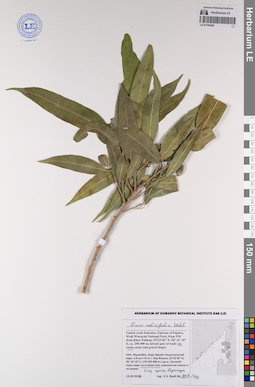
Ficus salicifolia Vahl det. Byalt, Vyacheslav Vyacheslavovich
Collectors: Byalt, Vyacheslav Vyacheslavovich; Korshunov, Mikhail Vladimirovich Field collecting number: 1691. Collection date: 23.11.2019. Administrative regions: AE - United Arab Emirates. Place of collection: Фуджейра, горы Хаджар. Граница эмиратов Фуджейра и Рас-эль-Хайма, старая дорога Масафи-Дибба, вади: на дне и боковых склонах и в каменистом сухом водотоке.Groups of specimens: Образцы общего сектора; Соглашение Минобрнауки №075-15-2021-1056; Бялт В.В.: Флора ФуджейрыOriginal label text: United Arab Emirates. Mts. Hajar. Border of emirate of Fujaira and Ras al Khaima, old road Masafi-Dibba, 25°21'17.57"N 56°10'47.12"E, ca. 515 m alt.: Wadi bottom and side slopes in a stony dry stream.– ОАЭ, Фуджейра, горы Хаджар. Граница эмиратов Фуджейра и Рас-эль-Хайма, старая дорога Масафи-Дибба, 25 ° 21'17.57 "N 56 ° 10'47.12" E, ок. 515 м. Вади: на дне и боковых склонах и в каменистом сухом водотоке, 23 XI 2019, fr., V.V. Byalt, M.V. Korshunov 1691
LE 01194347
Ficus amplissima Sm. det. Byalt, Vyacheslav Vyacheslavovich
Collectors: Byalt, Vyacheslav Vyacheslavovich; Korshunov, Mikhail Vladimirovich Field collecting number: 806/592. Collection date: 04.04.2018. Administrative regions: AE - United Arab Emirates. Place of collection: Фуджейра, пос. Аль Бидия: культивируется у забора сада.Groups of specimens: Образцы общего сектора; Соглашение Минобрнауки №075-15-2021-1056; Бялт В.В.: Флора ФуджейрыOriginal label text: United Arab Emirates. Emirate of Fujaira, village Al Bidiyah, 25°26'13" N, 56°20'2"° Е: cultivated by fence of garden.– ОАЭ, Фуджейра, посёлок Аль Бидия, 25°26'13" N, 56°20'2"° Е: культивируется у забора сада. 3 IV 2018, veg., V.V. Byalt, M.V. Korshunov 806/592
LE 01194349
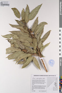
Ficus salicifolia Vahl det. Byalt, Vyacheslav Vyacheslavovich
Collectors: Byalt, Vyacheslav Vyacheslavovich; Korshunov, Mikhail Vladimirovich Field collecting number: 1722. Collection date: 23.11.2019. Administrative regions: AE - United Arab Emirates. Place of collection: Фуджейра, горы Хаджар. Граница эмиратов Фуджейра и Рас-эль-Хайма, старая дорога Масафи-Дибба, вади: на дне и боковых склонах, и в каменистом сухом водотоке.Groups of specimens: Образцы общего сектора; Соглашение Минобрнауки №075-15-2021-1056; Бялт В.В.: Флора ФуджейрыOriginal label text: United Arab Emirates. Mts. Hajar. Border of emirate of Fujaira and Ras al Khaima, old road Masafi-Dibba, 25°21'17.57"N 56°10'47.12"E, ca. 515 m alt.: Wadi bottom and side slopes in a stony dry stream.– ОАЭ, Фуджейра, горы Хаджар. Граница эмиратов Фуджейра и Рас-эль-Хайма, старая дорога Масафи-Дибба, 25 ° 21'17.57 "N 56 ° 10'47.12" E, ок. 515 м. Вади: на дне и боковых склонах и в каменистом сухом водотоке, 23 XI 2019, fr., V.V. Byalt, M.V. Korshunov 1722
LE 01194350
Ficus amplissima Sm. det. Byalt, Vyacheslav Vyacheslavovich at 19.05.2023
Additional identifications: Ficus cordata Thunb. det. Byalt, Vyacheslav Vyacheslavovich Collectors: Byalt, Vyacheslav Vyacheslavovich; Korshunov, Mikhail Vladimirovich Field collecting number: 1778/1757 (448). Collection date: 27.11.2019. Administrative regions: AE - United Arab Emirates. Place of collection: Фуджейра, морская набережная г. Фуджейра [точка 346]: сорное в поливных кругах между полосами шоссе, одичавшее, подрост.Groups of specimens: Образцы общего сектора; Соглашение Минобрнауки №075-15-2021-1056; Бялт В.В.: Флора ФуджейрыOriginal label text: United Arab Emirates. Emirate of Fujaira, seafront of the city of Al Fujeira, 25°06'38.35"N 56°21'27.04"E [point 346]: weed in irrigated round between highway lanes. – ОАЭ, Фуджейра, морская набережная г. Фуджейра, 25°06'38.35"N 56°21'27.04"E [точка 346]: сорняк в поливных кругах между полосами шоссе, одичавшее, подрост, 27 XI 2019, veg., V.V. Byalt & M.V. Korshunov 1757/448, 1778
LE 01194351
Ficus amplissima Sm. det. Byalt, Vyacheslav Vyacheslavovich
Additional identifications: Ficus cordata Thunb. det. Byalt, Vyacheslav Vyacheslavovich Collectors: Byalt, Vyacheslav Vyacheslavovich; Korshunov, Mikhail Vladimirovich Field collecting number: 1646. Collection date: 25.11.2019. Administrative regions: AE - United Arab Emirates. Place of collection: Фуджейра, окрестности пос. Мерба [точка 345]: вдоль стены в переулках, одичавшее.Groups of specimens: Образцы общего сектора; Соглашение Минобрнауки №075-15-2021-1056; Бялт В.В.: Флора ФуджейрыOriginal label text: United Arab Emirates. Emirate of Fujaira, Mirbah Beach, environs of vill. Mirbah, 25°16'15.29"N 56°22'06.41"E [point 345]: along wall in backstreet, run wild. – ОАЭ, Фуджейра, окресности пос. Мерба, 25°16'15.29"N 56°22'06.41"E [точка 345]: вдоль стены в переулках, одичавшее, 25 XI 2019, veg., V.V. Byalt & M.V. Korshunov 1646
LE 01194361
Ficus johannis Boiss. det. Byalt, Vyacheslav Vyacheslavovich
Collectors: Byalt, Vyacheslav Vyacheslavovich; Korshunov, Vladimir Mikhailovich; Melnikov, Denis Germanovich Field collecting number: 115 (2). Collection date: 18.04.2022. Administrative regions: AE - United Arab Emirates. Place of collection: Emirate of Fujaira, environs of Tawaian, high mountains on border with Musandam (Oman) [point 707d]: in stony valley of dry creek.Groups of specimens: Образцы общего сектора; Соглашение Минобрнауки №075-15-2021-1056; Бялт В.В.: Флора ФуджейрыOriginal label text: United Arab Emirates. Emirate of Fujaira, environs of Tawaian, high mountains on border with Musandam (Oman), 25°38’ N, 56° 07’ E, 1000–1126 m alt. [point 707d]: in stony valley of dry creek, 18 IV 2022, fr., veg., V.V. Byalt, V.M. Korshunov, D.G. Melnikov 115(2)
LE 01194363
Ficus carica L. det. Byalt, Vyacheslav Vyacheslavovich
Collectors: Byalt, Vyacheslav Vyacheslavovich; Korshunov, Mikhail Vladimirovich Field collecting number: 4399 (3). Collection date: 28.07.2020. Administrative regions: AE - United Arab Emirates. Place of collection: Fujairah Emirate, Al Dibba, Holiday Beach Motel & Resort, between Radisson Blu Fujairah and Royal Beach Hotel & Resort Fujairah [point 812]: run wild near AC condensate outlet.Groups of specimens: Образцы общего сектора; Соглашение Минобрнауки №075-15-2021-1056; Бялт В.В.: Флора ФуджейрыOriginal label text: United Arab Emirates, Fujairah Emirate, Al Dibba, Holiday Beach Motel & Resort, between Radisson Blu Fujairah and Royal Beach Hotel & Resort Fujairah. 25°35'56.93"N, 56°20'32.02"E, elevation 6 m [point 812]: run wild near AC condensate outlet, 28 VII 2020, veg., V.V. Byalt, M.V. Korshunov 4399(3)
LE 01194364
Ficus amplissima Sm. det. Byalt, Vyacheslav Vyacheslavovich
Collectors: Byalt, Vyacheslav Vyacheslavovich; Korshunov, Mikhail Vladimirovich Field collecting number: 4353 (2). Collection date: 28.07.2020. Administrative regions: AE - United Arab Emirates. Place of collection: Fujairah Emirate, Al Dibba, Holiday Beach Motel & Resort, between Radisson Blu Fujairah and Royal Beach Hotel & Resort Fujairah [point 812]: under trees, run wild on irrigation.Groups of specimens: Образцы общего сектора; Соглашение Минобрнауки №075-15-2021-1056; Бялт В.В.: Флора ФуджейрыOriginal label text: United Arab Emirates, Fujairah Emirate, Al Dibba, Holiday Beach Motel & Resort, between Radisson Blu Fujairah and Royal Beach Hotel & Resort Fujairah. 25°35'56.93"N, 56°20'32.02"E, elevation 6 m [point 812]: under trees, run wild on irrigation, 28 VII 2020, fr., V.V. Byalt, M.V. Korshunov 4353 (2)
LE 01194366
Ficus religiosa L. det. Byalt, Vyacheslav Vyacheslavovich
Collectors: Byalt, Vyacheslav Vyacheslavovich; Korshunov, Mikhail Vladimirovich Field collecting number: 4252 (2). Collection date: 28.07.2020. Administrative regions: AE - United Arab Emirates. Place of collection: Fujairah Emirate, Al Dibba, Holiday Beach Motel & Resort, between Radisson Blu Fujairah and Royal Beach Hotel & Resort Fujairah [point 812]: run wild near wall.Groups of specimens: Образцы общего сектора; Соглашение Минобрнауки №075-15-2021-1056; Бялт В.В.: Флора ФуджейрыOriginal label text: United Arab Emirates, Fujairah Emirate, Al Dibba, Holiday Beach Motel & Resort, between Radisson Blu Fujairah and Royal Beach Hotel & Resort Fujairah. 25°35'56.93"N, 56°20'32.02"E, elevation 6 m [point 812]: run wild near wall, 28 VII 2020, veg., V.V. Byalt, M.V. Korshunov 4252(2)
LE 01194368
Ficus benghalensis L. det. Byalt, Vyacheslav Vyacheslavovich
Collectors: Byalt, Vyacheslav Vyacheslavovich; Korshunov, Mikhail Vladimirovich Field collecting number: 4448. Collection date: 04.08.2020. Administrative regions: AE - United Arab Emirates. Place of collection: Fujairah Emirate, Al Aqah, Fujairah Rotana Resort & Spa, near Shark roundabout, next to Le Meridien Al Aqah Beach Resort [point 813]: run wild near fence.Groups of specimens: Образцы общего сектора; Соглашение Минобрнауки №075-15-2021-1056; Бялт В.В.: Флора ФуджейрыOriginal label text: United Arab Emirates, Fujairah Emirate, Al Aqah, Fujairah Rotana Resort & Spa, near Shark roundabout, next to Le Meridien Al Aqah Beach Resort. 25°30'30.31"N, 56°21'45.86"E, elevation 5 m [point 813]: run wild near fence, 4 VIII 2020, veg., V.V. Byalt, M.V. Korshunov 4448
LE 01194379
Ficus microcarpa L.f. det. Byalt, Vyacheslav Vyacheslavovich
Collectors: Byalt, Vyacheslav Vyacheslavovich; Korshunov, Mikhail Vladimirovich Field collecting number: 4421. Collection date: 04.08.2020. Administrative regions: AE - United Arab Emirates. Place of collection: Fujairah Emirate, Al Aqah, Fujairah Rotana Resort & Spa, near Shark roundabout, next to Le Meridien Al Aqah Beach Resort [point 813]: under trees, weed on irrigation, run wild.Groups of specimens: Образцы общего сектора; Соглашение Минобрнауки №075-15-2021-1056; Бялт В.В.: Флора ФуджейрыOriginal label text: United Arab Emirates, Fujairah Emirate, Al Aqah, Fujairah Rotana Resort & Spa, near Shark roundabout, next to Le Meridien Al Aqah Beach Resort. 25°30'30.31"N, 56°21'45.86"E, elevation 5 m [point 813]: under trees, weed on irrigation, run wild, 4 VIII 2020, veg., V.V. Byalt, M.V. Korshunov 4421
LE 01194394
Ficus amplissima Sm. det. Byalt, Vyacheslav Vyacheslavovich at 09.06.2023
Additional identifications: Ficus cordata Thunb. det. Byalt, Vyacheslav Vyacheslavovich Collectors: Byalt, Vyacheslav Vyacheslavovich; Korshunov, Vladimir Mikhailovich Field collecting number: 804. Collection date: 31.03.2018. Administrative regions: AE - United Arab Emirates. Place of collection: эмират Фуджейра, окрестности пос. Дадна, культивируется в небольшой деревне по дороге в горы из пос. Дадна.Groups of specimens: Образцы общего сектора; Соглашение Минобрнауки №075-15-2021-1056; Бялт В.В.: Флора ФуджейрыOriginal label text: United Arab Emirates. Emirate of Fujaira, env. of Dhadna, 25°31'02.2"N 56°17'50.2"E, ca. 150–200 m alt.: cultivated in small village on road to mountains from Dadnah. – ОАЭ, эмират Фуджейра, окр. пос. Дадна, 25°31'02.2"N 56°17'50.2"E, ca. 150–200 м н. ур. м.: культивируется в небольшой деревне по дорогев горы из Дадны, 31 III 2018, veg., V.V. Byalt, V.M. Korshunov 804
LE 01194395
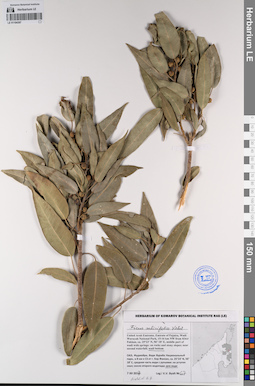
Ficus salicifolia Vahl det. Byalt, Vyacheslav Vyacheslavovich
Collectors: Byalt, Vyacheslav Vyacheslavovich Field collecting number: 803/219. Collection date: 13.12.2017. Administrative regions: AE - United Arab Emirates. Place of collection: Фуджейра, Вади Вурайа Национальный парк, в 8 км северо-западнее г. Хор Факкан, боковой отрог вади: на уступах скал, близ сухого водопада.Groups of specimens: Образцы общего сектора; Соглашение Минобрнауки №075-15-2021-1056; Бялт В.В.: Флора ФуджейрыOriginal label text: United Arab Emirates. Emirate of Fujaira, Wadi Wurayah National Park, 8 km NW from Khor Fakkan, 25°23’46” N, 56° 16’ 10” E, ca. 250–400 m, lateral spur of wadi: on rocks.– ОАЭ, Фуджейра, Вади Вурайа Национальный парк, в 8 км к СЗ от г. Хор Факкан, 25°23’ 35” N, 56° 16’ 10” E, боковой отрог вади: на уступах скал, близ сухого водопада, 13 III 2017, veg., V.V. Byalt 803/219
LE 01194396
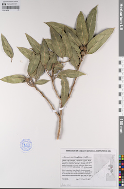
Ficus salicifolia Vahl det. Byalt, Vyacheslav Vyacheslavovich
Collectors: Byalt, Vyacheslav Vyacheslavovich Field collecting number: 68. Collection date: 07.12.2017. Administrative regions: AE - United Arab Emirates. Place of collection: Фуджейра, Вади Вурайа Национальный парк, в 8 км северо-западнее г. Хор Факкан, средняя часть вади с ручьями: дно вади.Groups of specimens: Образцы общего сектора; Соглашение Минобрнауки №075-15-2021-1056; Бялт В.В.: Флора ФуджейрыOriginal label text: United Arab Emirates. Emirate of Fujaira, Wadi Wurayah National Park, 15-16 km NW from Khor Fakkan, ca. 25°23’ N, 56° 18’ E, middle part of wadi with springs: wadi bottom.– ОАЭ, Фуджейра, Вади Вурайа Национальный парк, в 8 км к СЗ от г. Хор Факкан, ca. 25°23’ N, 56° 18’ E, средняя часть вади с ручьями: дно вади, 7 XII 2017, fr.,V.V. Byalt 68
LE 01194397
Ficus salicifolia Vahl det. Byalt, Vyacheslav Vyacheslavovich
Collectors: Byalt, Vyacheslav Vyacheslavovich Field collecting number: 67. Collection date: 07.12.2017. Administrative regions: AE - United Arab Emirates. Place of collection: Фуджейра, Вади Вурайа Национальный парк, в 8 км северо-западнее г. Хор Факкан, средняя часть вади с ручьями: дно вади.Groups of specimens: Образцы общего сектора; Соглашение Минобрнауки №075-15-2021-1056; Бялт В.В.: Флора ФуджейрыOriginal label text: United Arab Emirates. Emirate of Fujaira, Wadi Wurayah National Park, 15-16 km NW from Khor Fakkan, ca. 25°23’ N, 56° 18’ E, middle part of wadi with springs: wadi bottom.– ОАЭ, Фуджейра, Вади Вурайа Национальный парк, в 8 км к СЗ от г. Хор Факкан, ca. 25°23’ N, 56° 18’ E, средняя часть вади с ручьями: дно вади, 7 XII 2017, fr.,V.V. Byalt 67
LE 01194398
Ficus salicifolia Vahl det. Byalt, Vyacheslav Vyacheslavovich
Collectors: Byalt, Vyacheslav Vyacheslavovich Field collecting number: 66. Collection date: 07.12.2017. Administrative regions: AE - United Arab Emirates. Place of collection: Фуджейра, Вади Вурайа Национальный парк, в 8 км северо-западнее г. Хор Факкан, средняя часть вади с ручьями: дно вади, в верхней части.Groups of specimens: Образцы общего сектора; Соглашение Минобрнауки №075-15-2021-1056; Бялт В.В.: Флора ФуджейрыOriginal label text: United Arab Emirates. Emirate of Fujaira, Wadi Wurayah National Park, 15-16 km NW from Khor Fakkan, ca. 25°23’ N, 56° 18’ E, middle part of wadi with springs: wadi bottom in upper part.– ОАЭ, Фуджейра, Вади Вурайа Национальный парк, в 8 км к СЗ от г. Хор Факкан, ca. 25°23’ N, 56° 18’ E, средняя часть вади с ручьями: дно вади, в верхней части, 7 XII 2017, fr.,V.V. Byalt 66
LE 01194641
Cocculus pendulus (J. R. Forst. & G. Forst.) Diels det. Byalt, Vyacheslav Vyacheslavovich
Collectors: Byalt, Vyacheslav Vyacheslavovich; Korshunov, Mikhail Vladimirovich Field collecting number: 271. Collection date: 11.03.2020. Administrative regions: AE - United Arab Emirates. Place of collection: Fujairah Emirate, Al Hayl Fort (Al Hayl Castle) [point 704]: on Ficus, near the Fort, near the water intake.Groups of specimens: Образцы общего сектора; Соглашение Минобрнауки №075-15-2021-1056; Бялт В.В.: Флора ФуджейрыOriginal label text: United Arab Emirates, Fujairah Emirate, Al Hayl Fort (Al Hayl Castle). 25° 5'4.59"N, 56°13'36.84"E, elevation 240–310 m [point 704]: on Ficus, near the Fort, near the water intake, 11 III 2020, fr., V.V. Byalt, M.V. Korshunov 271