View
Add
Copy
Edit
Delete
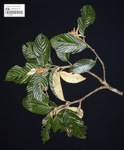
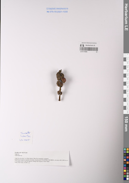
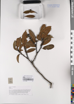
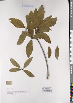
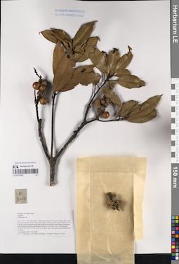
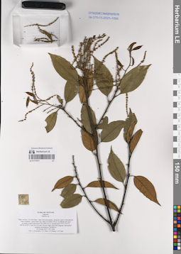
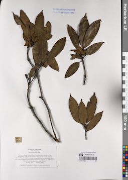
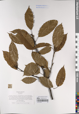
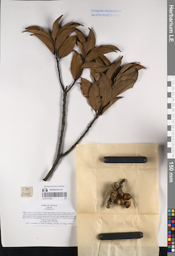
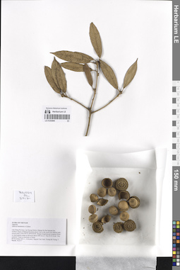
LE 01125084
Quercus sp. det. Averyanov, Leonid Vladimirovich at 04.05.2024
Collectors: Nguyen Huu Cuong; Nguyen Van Ly; Averyanov, Leonid Vladimirovich; Maisak, Tatiana Viktorovna Field collecting number: AL3080. Collection date: 04.05.2024. Administrative regions: VN - Tinh Thanh Hoa. Groups of specimens: L. V. Averyanov specimens; L. V. Averyanov photos; Flora of VietnamOriginal label text:FLORA OF VIETNAM
Fagaceae
Quercus sp.
Thanh Hoa Province, Quan Hoa District, Nam Dong Community, Ban Lo Village, Ke Stream, the territory of Nam Dong National Reserve around point 22º25’46’’N 105º36’58’E. Primary and old secondary broad-leaved evergreen humid forest on very steep rocky slopes on solid, marble-like highly eroded limestone at elevation 900–1200 m a.s.l. on steep rocky slope. Medium size tree on rocky mossy mountain top. Occasional.
04 May 2024, Nguyen Huu Cuong, Nguyen Van Ly, L. Averyanov, T. Maisak, AL3080.
All photos © L. Averyanov
Record creation: 2024-06-19, Аверьянов Леонид Владимирович. Processing status: work_status_1Citation: Specimen LE 01125084 // Virtual herbarium of Komarov Botanical Institute RAS — http://re.herbariumle.ru/01125084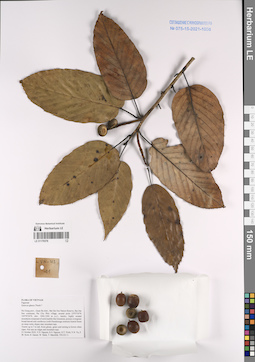
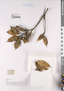
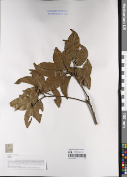
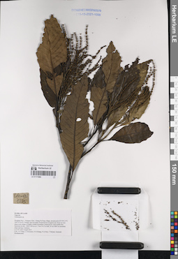
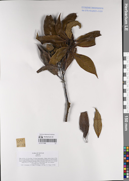
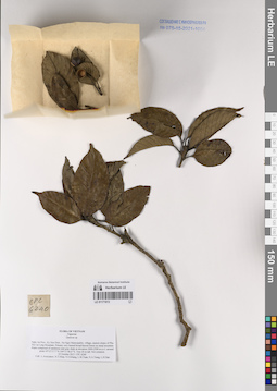
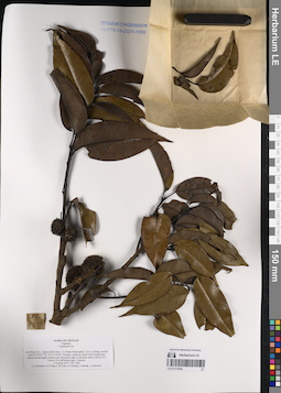
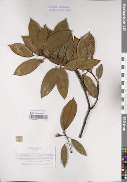
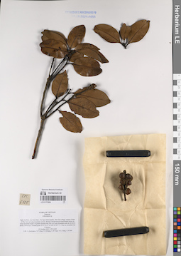
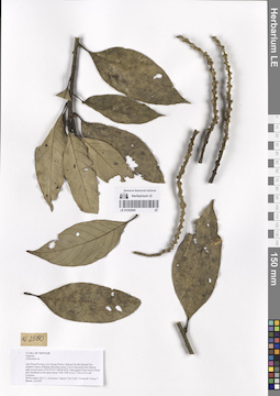
LE 01170376
Quercus glauca Thunb. ⟮prelim. ID⟯ det. Nguyen Van Du at 21.10.2022
Collectors: Nguyen Van Du; Khang Sinh Nguyen; et al. Field collecting number: VN-US11. Collection date: 21.10.2022. Administrative regions: VN - Tinh Ha Giang. Groups of specimens: L. V. Averyanov specimens; L. V. Averyanov herbarium; Соглашение Минобрнауки №075-15-2021-1056; Flora of VietnamOriginal label text:FLORA OF VIETNAM
Fagaceae
Quercus glauca Thunb.?
Ha Giang Prov.
V.D. Nguyen, Khang Sinh Nguyen et al, VN-US11
21.10.2022.
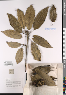
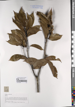
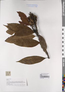
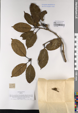
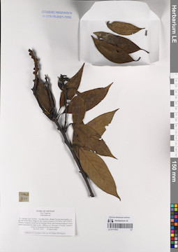
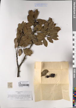
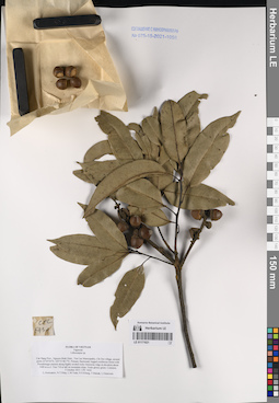
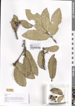
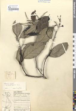
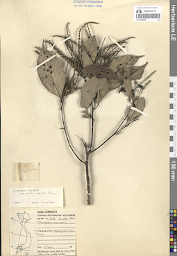
LE 01170378
Quercus thorelii Hickel & A.Camus ⟮prelim. ID⟯ det. Nguyen Van Du at 21.10.2022
Collectors: Nguyen Van Du; Khang Sinh Nguyen; et al. Field collecting number: VN-US06. Collection date: 21.10.2022. Administrative regions: VN - Tinh Ha Giang. Groups of specimens: L. V. Averyanov specimens; L. V. Averyanov herbarium; Соглашение Минобрнауки №075-15-2021-1056; Flora of VietnamOriginal label text:FLORA OF VIETNAM
Fagaceae
Quercus aff. thorelii Hickel & A.Camus.?
Ha Giang Prov.
Nguyen Van Du , Khang Sinh Nguyen et al., VN-US06
21.10.2022.
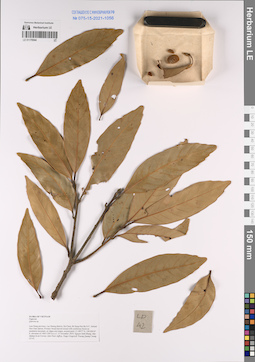
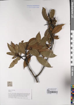
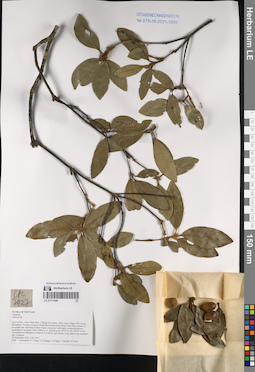
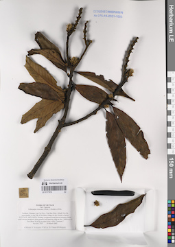
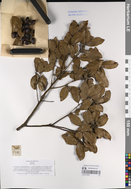
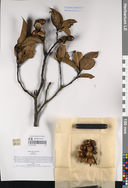
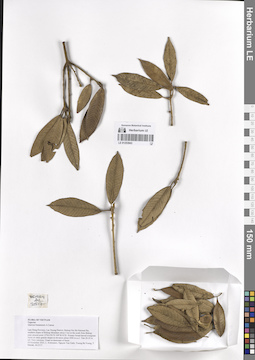
LE 01170544
Quercus sp. det. Khang Sinh Nguyen, Averyanov, Leonid Vladimirovich at 15.11.2019
Collectors: Khang Sinh Nguyen; et al. Field collecting number: LD042. Collection date: 15.11.2019. Administrative regions: VN - Tinh Lam GJong. Groups of specimens: L. V. Averyanov specimens; L. V. Averyanov herbarium; Соглашение Минобрнауки №075-15-2021-1056; Flora of VietnamOriginal label text:FLORA OF VIETNAM
Fagaceae
Quercus sp.
Lam Dong province, Lac Duong district, Da Chais, Bi Doup-Nui Ba N.P., behind Hon Giao station, Primary broad-leaved mixed with coniferous forest on sandstone mountain, at ridges and slopes, around point 12.18977o N, 108.68414o E, elevation of 1460-1500 m a.s.l. 15 November 2019, Nguyen Sinh Khang, Mac Mahan Scott Forrest, Zale Peter Jeffrey, Paige Gregory& Truong Quang Cuong, LD 42.

LE 01170555
Castanopsis sp. det. Khang Sinh Nguyen at 25.10.2022
Collectors: Khang Sinh Nguyen; et al. Field collecting number: LC-DKT011. Collection date: 25.10.2022. Administrative regions: VN - Tinh Lao Cai. Groups of specimens: L. V. Averyanov specimens; L. V. Averyanov herbarium; Соглашение Минобрнауки №075-15-2021-1056; Flora of VietnamOriginal label text:FLORA OF VIETNAM
Fagaceae
Castanopsis sp.
Lao Cai prov., Sa Pa distr., Ngu Chi Son commune, on the trail to Ngu Chi Son mountain, around point from N22.42325º E103.75105º to N22.40975º E103.74072º, alt. 1800-2500 m a.s.l., primary evergreen broad-leaved humid forest on granite mountain.Tree up to 10 m tall. Common.
24-25 October 2022, Van Du Nguyen, Khang Sinh Nguyen, Xuan Thanh Trinh, Van Nam Vu, F. M. Scott, H. Daniel, W. Mark, T. Marchlik, LC-DKT 11
LE 01170595
Lithocarpus sp. det. Nguyen Van Du at 03.11.2022
Collectors: Nguyen Van Du; Khang Sinh Nguyen; et al. Field collecting number: LS-DKT s.n.. Collection date: 03.11.2022. Administrative regions: VN - Tinh Lang Son. Groups of specimens: L. V. Averyanov specimens; L. V. Averyanov herbarium; Соглашение Минобрнауки №075-15-2021-1056; Flora of VietnamOriginal label text:FLORA OF VIETNAM
Record creation: 2023-05-10, Galina Savich, PhotoScan D2.. Processing status: work_status_1Citation: Specimen LE 01170595 // Virtual herbarium of Komarov Botanical Institute RAS — http://re.herbariumle.ru/01170595Fagaceae
Lithocarpus sp.
Lang Son Prov.
Nguyen Van Du, Khang Sinh Nguyen et al.
LS-DKT s.n., 03.11.2022.
LE 01170695
Lithocarpus sp. det. Nguyen Van Du at 25.10.2022
Collectors: Nguyen Van Du; Khang Sinh Nguyen; et al. Field collecting number: LC-DKT15. Collection date: 25.10.2022. Administrative regions: VN - Tinh Lao Cai. Groups of specimens: L. V. Averyanov specimens; L. V. Averyanov herbarium; Соглашение Минобрнауки №075-15-2021-1056; Flora of VietnamOriginal label text:FLORA OF VIETNAM
Fagaceae
Lithocarpus sp.
Lao Cai prov., Sa Pa distr., Ngu Chi Son commune, on the trail to Ngu Chi Son mountain, around point from N22.42325º E103.75105º to N22.40975º E103.74072º, alt. 1800-2500 m a.s.l., primary evergreen broad-leaved humid forest on granite mountain. Tree up to 12 m tall. Not rare. 24-25 October 2022, Van Du Nguyen, Khang Sinh Nguyen, Xuan Thanh Trinh, Van Nam Vu, F. M. Scott, H. Daniel, W. Mark, T. Marchlik, LC-DKT 15.
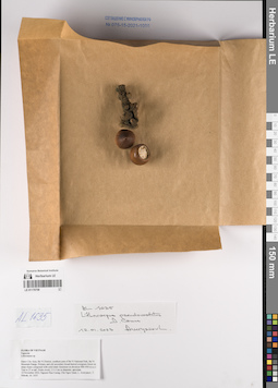
LE 01170758
Lithocarpus pseudovestitus A.Camus. det. Averyanov, Leonid Vladimirovich at 12.01.2023
Collectors: Nguyen Huu Cuong; Chu Ngoc Quan; Averyanov, Leonid Vladimirovich; Maisak, Tatiana Viktorovna Field collecting number: AL1635. Collection date: 12.11.2022. Administrative regions: VN - Thanh Pho Ha Noi. Groups of specimens: L. V. Averyanov specimens; L. V. Averyanov herbarium; Соглашение Минобрнауки №075-15-2021-1056; Flora of VietnamOriginal label text:FLORA OF VIETNAM
Fagaceae
Lithocarpus sp.
Hanoi City Area, Ba Vi District, southern prat of Ba Vi National Park, Ba Vi Mountain Range. Primary and old secondary broad-leaved evergreen forest on steep slopes composed with solid shaly limestone at elevation 900–950 m a.s.l. Tree to 25 m tall. Fruits ovoid, 2.5–3 cm in diameter, apiculate.
12 November 2022, Nguyen Huu Cuong, Chu Ngoc Quan, L. Averyanov, T. Maisak, AL 1635.
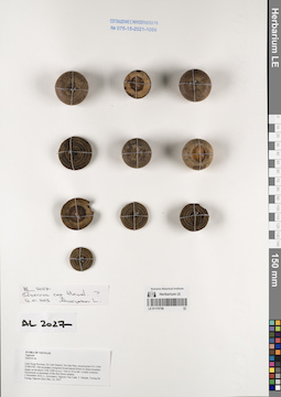
LE 01170759
Quercus rex Hemsl. det. Averyanov, Leonid Vladimirovich at 01.12.2022
Collectors: Averyanov, Leonid Vladimirovich; Nguyen Van Canh; Maisak, Tatiana Viktorovna; Truong Ba Vuong; Nguyen Quoc Bao Field collecting number: AL2027. Collection date: 01.12.2022. Administrative regions: VN - Tinh Lam GJong. Groups of specimens: L. V. Averyanov specimens; L. V. Averyanov herbarium; Соглашение Минобрнауки №075-15-2021-1056; Flora of VietnamOriginal label text:FLORA OF VIETNAM
Fagaceae
Quercus sp.
Lam Dong Province, Di Linh District, Nui San Pass, around point N11.2566 E108.0383.
Old secondary evergreen broad-leaved forest on steep mountain slopes at elevation 1100–1200 m a.s.l.
Tree to 30 m tall. Locally common. Occasional co-dominant of the first forest stratum.
1 December 2022, L. Averyanov, Nguyen Van Canh, T. Maisak, Truong Ba Vuong, Nguyen Quoc Bao, AL 2027.
LE 01170999
Castanopsis sp. det. Averyanov, Leonid Vladimirovich at 23.09.2016
Collectors: Averyanov, Leonid Vladimirovich; Tien Hiep Nguyen; et al. Field collecting number: CPC7990. Collection date: 23.09.2016. Administrative regions: VN - Tinh Son La. Groups of specimens: L. V. Averyanov specimens; L. V. Averyanov herbarium; Соглашение Минобрнауки №075-15-2021-1056; Flora of VietnamOriginal label text:FLORA OF VIETNAM
Fagaceae
Castanopsis sp.
Son La Prov., Moc Chau Distr., Chieng Son comm., Pha Luong village, Pha Luong Mountain (elevation from Pha Luong village at 930 m to Mt. peak at 1860 m a.s.l.). Open secondary scrub after fire on flat sandy Pha Luong summit composed with eroded red-brown sandstone at elevation 1800-1850 m a.s.l. around point 20°40’23.0N 104°37’52.0E. Tree 6-8 m tall. Fruits light green. Common.
23 September 2016 CPC 7990
Coll.: L.Averyanov, N.T.Hiep, N.S.Khang, C.Q.Ngan, T.V.Maisak, N.T.Son.
LE 01171000
Quercus sp. det. Averyanov, Leonid Vladimirovich at 27.09.2016
Collectors: Averyanov, Leonid Vladimirovich; Tien Hiep Nguyen; et al. Field collecting number: CPC8094. Collection date: 27.09.2016. Administrative regions: VN - Tinh Son La. Groups of specimens: L. V. Averyanov specimens; L. V. Averyanov herbarium; Соглашение Минобрнауки №075-15-2021-1056; Flora of VietnamOriginal label text:FLORA OF VIETNAM
Fagaceae
Quercus sp.
Son La Prov., Moc Chau Distr., Chieng Son comm., about 1 km to NE from Chieng Son Village, around point 20°46’02.0N 104°37’03.1E. Remnants of primary broad-leaved evergreen forest on tops of hills composed with karstic highly eroded yellow-white limestone at elevation 1150-1250 m a.s.l. Tree 6-8 m tall on mountain top. Not rare.
27 September 2016 CPC 8094
Coll.: L.Averyanov, N.T.Hiep, N.S.Khang, C.Q.Ngan, T.V.Maisak, N.T.Son.
LE 01171001
Quercus sp. det. Averyanov, Leonid Vladimirovich at 27.09.2016
Collectors: Averyanov, Leonid Vladimirovich; Tien Hiep Nguyen; et al. Field collecting number: CPC8093. Collection date: 27.09.2016. Administrative regions: VN - Tinh Son La. Groups of specimens: L. V. Averyanov specimens; L. V. Averyanov herbarium; Соглашение Минобрнауки №075-15-2021-1056; Flora of VietnamOriginal label text:FLORA OF VIETNAM
Fagaceae
Quercus sp.
Son La Prov., Moc Chau Distr., Chieng Son comm., about 1 km to NE from Chieng Son Village, around point 20°46’02.0N 104°37’03.1E. Remnants of primary broad-leaved evergreen forest on tops of hills composed with karstic highly eroded yellow-white limestone at elevation 1150-1250 m a.s.l. Tree 6-8 m tall on mountain top. Not rare.
27 September 2016 CPC 8093
Coll.: L.Averyanov, N.T.Hiep, N.S.Khang, C.Q.Ngan, T.V.Maisak, N.T.Son.
LE 01171002
Castanopsis sp. det. Averyanov, Leonid Vladimirovich at 23.09.2016
Collectors: Averyanov, Leonid Vladimirovich; Tien Hiep Nguyen; et al. Field collecting number: CPC7990. Collection date: 23.09.2016. Administrative regions: VN - Tinh Son La. Groups of specimens: L. V. Averyanov specimens; L. V. Averyanov herbarium; Соглашение Минобрнауки №075-15-2021-1056; Flora of VietnamOriginal label text:FLORA OF VIETNAM
Fagaceae
Castanopsis sp.
Son La Prov., Moc Chau Distr., Chieng Son comm., Pha Luong village, Pha Luong Mountain (elevation from Pha Luong village at 930 m to Mt. peak at 1860 m a.s.l.). Open secondary scrub after fire on flat sandy Pha Luong summit composed with eroded red-brown sandstone at elevation 1800-1850 m a.s.l. around point 20°40’23.0N 104°37’52.0E. Tree 6-8 m tall. Fruits light green. Common.
23 September 2016 CPC 7990
Coll.: L.Averyanov, N.T.Hiep, N.S.Khang, C.Q.Ngan, T.V.Maisak, N.T.Son.
LE 01171003
Quercus sp. det. Tien Hiep Nguyen at 11.04.2015
Collectors: Tien Hiep Nguyen; Averyanov, Leonid Vladimirovich; et al. Field collecting number: LA-VN1262. Collection date: 11.04.2015. Administrative regions: LA - Houaphan. Groups of specimens: L. V. Averyanov specimens; L. V. Averyanov herbarium; Соглашение Минобрнауки №075-15-2021-1056; Flora of LaosOriginal label text:FLORA OF LAOS
Fagaceae
Quercus sp.
Houphan Prov., Xon Distr., Nong Hua Pa Noi village, around point 20°13'02.1''N 103°24'23.3''E. Primary and secondary broad-leaved evergreen forest on very steep rocky mountain slopes composed by shaly limestone at elev. 1100-1200 m a.s.l.
Tree 20-30 m tall. Common.
LA-VN 1262 11 April 2015
Coll.: N.T.Hiep, L.Averyanov, N.S.Khang, N.Q.Hieu, T.Maisak, Pheng Phengsintham.
LE 01171004
Castanopsis sp. det. Tien Hiep Nguyen at 08.04.2015
Collectors: Tien Hiep Nguyen; Averyanov, Leonid Vladimirovich; et al. Field collecting number: LA-VN1225. Collection date: 08.04.2015. Administrative regions: LA - Houaphan. Groups of specimens: L. V. Averyanov specimens; L. V. Averyanov herbarium; Соглашение Минобрнауки №075-15-2021-1056; Flora of LaosOriginal label text:FLORA OF LAOS
Fagaceae
Castanopsis sp.
Houphan Prov., Viengxay Distr., Khang Pa Pong village, around point 20°19'41.4''N 104°25'10.6''E. Primary and secondary broad-leaved evergreen dry forest on very steep rocky slopes of highly eroded mountains composed by solid marble-like limestone at elev. 1000-1100 m a.s.l. Tree 10-12 m tall, 20 cm DBH on mountain slope and top. Common.
LA-VN 1225 8 April 2015
Coll.: N.T.Hiep, L.Averyanov, N.S.Khang, N.Q.Hieu, T.Maisak, Somneuk Bouthamounty.
LE 01171005
Lithocarpus sp. det. Tien Hiep Nguyen at 02.04.2015
Collectors: Tien Hiep Nguyen; Averyanov, Leonid Vladimirovich; et al. Field collecting number: LA-VN898. Collection date: 02.04.2015. Administrative regions: LA - Xiangkhouang. Groups of specimens: L. V. Averyanov specimens; L. V. Averyanov herbarium; Соглашение Минобрнауки №075-15-2021-1056; Flora of LaosOriginal label text:FLORA OF LAOS
Fagaceae
Lithocarpus sp.
Xiangkhouang Prov., Peak Distr., Oran village, around point 19°38’53”N 103°23’12”E. Primary and secondary broad-leaved evergreen dry forest on shale sandstone slopes and along ridge edge at elev. about 1750-1850 m a.s.l. Tree 10 m tall. Common.
LA-VN 898 2 April 2015
Coll.: N.T.Hiep, L.Averyanov, N.S.Khang, N.Q.Hieu, T.Maisak, Pheng Phengsintham.
LE 01171006
Quercus sp. det. Averyanov, Leonid Vladimirovich at 22.09.2016
Collectors: Averyanov, Leonid Vladimirovich; Tien Hiep Nguyen; et al. Field collecting number: CPC7927. Collection date: 22.09.2016. Administrative regions: VN - Tinh Son La. Groups of specimens: L. V. Averyanov specimens; L. V. Averyanov herbarium; Соглашение Минобрнауки №075-15-2021-1056; Flora of VietnamOriginal label text:FLORA OF VIETNAM
Fagaceae
Quercus sp.
Son La Prov., Moc Chau Distr., Chieng Son comm., Pha Luong village, Pha Luong Mountains. Primary evergreen broad-leaved and mixed forest with Pinus cernua on mountain tops and steep summit slopes composed with highly eroded red-brown sandstone at elevation 1400-1500 m a.s.l. around point 20°41’33.2N 104°37’37.0E. Terrestrial and lithophytic treelet to 5 m tall in open mossy rocky place near mountain top. Common.
22 September 2016 CPC 7927.
Coll.: L.Averyanov, N.T.Hiep, N.S.Khang, C.Q.Ngan, T.V.Maisak, N.T.Son.
LE 01171007
Lithocarpus sp. det. Averyanov, Leonid Vladimirovich at 23.09.2016
Collectors: Averyanov, Leonid Vladimirovich; Tien Hiep Nguyen; et al. Field collecting number: CPC8008. Collection date: 23.09.2016. Administrative regions: VN - Tinh Son La. Groups of specimens: L. V. Averyanov specimens; L. V. Averyanov herbarium; Соглашение Минобрнауки №075-15-2021-1056; Flora of VietnamOriginal label text:FLORA OF VIETNAM
Fagaceae
Lithocarpus sp.
Son La Prov., Moc Chau Distr., Chieng Son comm., Pha Luong village, Pha Luong Mountain (elevation from Pha Luong village at 930 m to Mt. peak at 1860 m a.s.l.). Primary cloud evergreen broad-leaved forest on flat Pha Luong summit composed with eroded red-brown sandstone at elevation 1750-1850 m a.s.l. around point 20°40’23.0N 104°37’52.0E. Tree 7-9 m tall in open rocky place near mountain top. Common.
23 September 2016 CPC 8008.
Coll.: L.Averyanov, N.T.Hiep, N.S.Khang, C.Q.Ngan, T.V.Maisak, N.T.Son.
LE 01171008
Quercus sp. det. Averyanov, Leonid Vladimirovich at 25.10.2013
Collectors: Averyanov, Leonid Vladimirovich; Tien Hiep Nguyen; et al. Field collecting number: CPC6238. Collection date: 25.10.2013. Administrative regions: VN - Tinh Nghe An. Groups of specimens: L. V. Averyanov specimens; L. V. Averyanov herbarium; Соглашение Минобрнауки №075-15-2021-1056; Flora of VietnamOriginal label text:FLORA OF VIETNAM
Fagaceae
Quercus sp.
Nghe An Prov., Ky Son Distr., Na Ngoi Municipality, eastern slopes of Phu Xai Lai Leng Mountain. Primary very humid broad-leaved forest on steep mountain slopes composed of sandstone and gray shale at elevation 2400-2500 m a.s.l. around point 19°12’17.7’’N 104°11’06.6’’E. Tree 20-30 m tall. Very common.
25 October 2013 CPC 6238
Coll.: L.Averyanov, N.T.Hiep, N.S.Khang, L.M.Tuan, N.A.Trang, L.H.Dan
LE 01171009
Quercus sp. det. Averyanov, Leonid Vladimirovich at 25.10.2013
Collectors: Averyanov, Leonid Vladimirovich; Tien Hiep Nguyen; et al. Field collecting number: CPC6235. Collection date: 25.10.2013. Administrative regions: VN - Tinh Nghe An. Groups of specimens: L. V. Averyanov specimens; L. V. Averyanov herbarium; Соглашение Минобрнауки №075-15-2021-1056; Flora of VietnamOriginal label text:FLORA OF VIETNAM
Fagaceae
Quercus sp.
Nghe An Prov., Ky Son Distr., Na Ngoi Municipality, eastern slopes of Phu Xai Lai Leng Mountain. Primary very humid broad-leaved forest on steep mountain slopes composed of sandstone and gray shale at elevation 2400-2500 m a.s.l. around point 19°12’17.7’’N 104°11’06.6’’E. Tree 20 m tall. Common.
25 October 2013 CPC 6235
Coll.: L.Averyanov, N.T.Hiep, N.S.Khang, L.M.Tuan, N.A.Trang, L.H.Dan
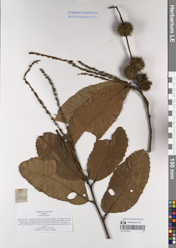
LE 01171010
Castanopsis indica A.DC. ⟮prelim. ID⟯ det. Averyanov, Leonid Vladimirovich at 01.11.2013
Collectors: Averyanov, Leonid Vladimirovich; Tien Hiep Nguyen; Khang Sinh Nguyen Field collecting number: CPC6428. Collection date: 01.11.2013. Administrative regions: VN - Tinh Thanh Hoa. Groups of specimens: L. V. Averyanov specimens; L. V. Averyanov herbarium; Соглашение Минобрнауки №075-15-2021-1056; Flora of VietnamOriginal label text:FLORA OF VIETNAM
Fagaceae
Castanopsis indica?
Thanh Hoa Prov., Thuong Xuan Distr., Bat Mot Municipality, Vin village, Xuan Lien Natural Reserve. Remnants of primary broad-leaved evergreen humid forest on rocky, highly eroded, crystalline limestone at elevation 750-800 m a.s.l. around point 19°59’11.4’’N 104°58’31.8’’E. Tree to 15 m tall along steep rocky stream slope. Very common.
1 November 2013 CPC 6428
L.Averyanov, N.T.Hiep, N.S.Khang
LE 01171011
Quercus sp. det. Averyanov, Leonid Vladimirovich at 29.10.2013
Collectors: Averyanov, Leonid Vladimirovich; Tien Hiep Nguyen; et al. Field collecting number: CPC6406. Collection date: 29.10.2013. Administrative regions: VN - Tinh Nghe An. Groups of specimens: L. V. Averyanov specimens; L. V. Averyanov herbarium; Соглашение Минобрнауки №075-15-2021-1056; Flora of VietnamOriginal label text:FLORA OF VIETNAM
Fagaceae
Quercus sp.
Nghe An Prov., Ky Son Distr., Nam Can municipality, along the road to international Gate (Vietnam - Laos) Nam Can.
Open secondary forest, woodlands and open secondary scrub at elevation 750-1000 m a.s.l. around point 19°27’19.4’’N 104°06’25.8’’E. Tree 10-15 m tall. Flowers light yellowish, fragrant. Particularly common at elevations 700-800 m.
29 October 2013 CPC 6406
Coll.: L.Averyanov, N.T.Hiep, N.S.Khang, L.M.Tuan
LE 01171012
Lithocarpus sp. det. Averyanov, Leonid Vladimirovich at 19.03.2002
Collectors: Averyanov, Leonid Vladimirovich; Phan Ke Loc; D.T. Doan Field collecting number: HAL2514. Collection date: 19.03.2002. Administrative regions: VN - Tinh Lao Cai. Groups of specimens: L. V. Averyanov specimens; L. V. Averyanov herbarium; Соглашение Минобрнауки №075-15-2021-1056; Flora of VietnamOriginal label text:FLORA OF VIETNAM
Fam. Fagaceae
Lithocarpus sp.
Northern Vietnam, Lao Cai Prov., Van Ban Distr., Khanh Yen Ha municipality, to the SW of Na Nheo village (in the vicinity of point 21ш57'34''N, 104ш13'49''E). Primary evergreen broad-leaved montane forest with Fokienia hodginsii along granite and quartzite ridge at elev. 1900 m a.s.l. Tree up to 35 m hg. Common. Usual co-dominant of first forest stratum.
No HAL 2514 19 March 2002
_______________________________________________
Collectors: L.Averyanov, P.K.Loc, D.T.Doan (FFI Project).
LE 01171013
Quercus sp. det. Averyanov, Leonid Vladimirovich at 25.10.2013
Collectors: Averyanov, Leonid Vladimirovich; Tien Hiep Nguyen; et al. Field collecting number: CPC6240. Collection date: 25.10.2013. Administrative regions: VN - Tinh Nghe An. Groups of specimens: L. V. Averyanov specimens; L. V. Averyanov herbarium; Соглашение Минобрнауки №075-15-2021-1056; Flora of VietnamOriginal label text:FLORA OF VIETNAM
Fagaceae
Quercus sp.
Nghe An Prov., Ky Son Distr., Na Ngoi Municipality, eastern slopes of Phu Xai Lai Leng Mountain. Primary very humid broad-leaved forest on steep mountain slopes composed of sandstone and gray shale at elevation 2400-2500 m a.s.l. around point 19°12’17.7’’N 104°11’06.6’’E. Tree 20 m tall. Not common.
25 October 2013 CPC 6240
Coll.: L.Averyanov, N.T.Hiep, N.S.Khang, L.M.Tuan, N.A.Trang, L.H.Dan
LE 01171014
Lithocarpus truncatus Rehder. det. Averyanov, Leonid Vladimirovich at 19.03.2002
Collectors: Averyanov, Leonid Vladimirovich; Phan Ke Loc; et al. Field collecting number: HAL2527. Collection date: 19.03.2002. Administrative regions: VN - Tinh Lao Cai. Groups of specimens: L. V. Averyanov specimens; L. V. Averyanov herbarium; Соглашение Минобрнауки №075-15-2021-1056; Flora of VietnamOriginal label text:FLORA OF VIETNAM
Fam. Fagaceae
Lithocarpus truncatus (Hook.f.) Rehder et Wils.
Northern Vietnam, Lao Cai Prov., Van Ban Distr., Khanh Yen Ha municipality, to the SW of Na Nheo village (in the vicinity of point 21ш57'34''N, 104ш13'49''E). Primary evergreen broad-leaved montane forest with Fokienia hodginsii along granite and quartzite ridge at elev. 1900 m a.s.l. Tree about 10 m hg on open rocky cliffs. Common ?
No HAL 2527 19 March 2002
_______________________________________________
Collectors: L.Averyanov, P.K.Loc, D.T.Doan (FFI Project).
LE 01171015
Quercus annulata Buckley. det. Averyanov, Leonid Vladimirovich at 19.03.2002
Collectors: Averyanov, Leonid Vladimirovich; Phan Ke Loc; et al. Field collecting number: HAL2525. Collection date: 19.03.2002. Administrative regions: VN - Tinh Lao Cai. Groups of specimens: L. V. Averyanov specimens; L. V. Averyanov herbarium; Соглашение Минобрнауки №075-15-2021-1056; Flora of VietnamOriginal label text:FLORA OF VIETNAM
Fam. Fagaceae
Quercus annulata Wall.
Northern Vietnam, Lao Cai Prov., Van Ban Distr., Khanh Yen Ha municipality, to the SW of Na Nheo village (in the vicinity of point 21ш57'34''N, 104ш13'49''E). Primary evergreen broad-leaved montane forest with Fokienia hodginsii along granite and quartzite ridge at elev. 1900 m a.s.l. Tree 6-8 m hg on open rocky cliffs. Not rare.
No HAL 2525 19 March 2002
_______________________________________________
Collectors: L.Averyanov, P.K.Loc, D.T.Doan (FFI Project).
LE 01171016
Castanopsis sp. det. Averyanov, Leonid Vladimirovich at 04.10.2013
Collectors: Averyanov, Leonid Vladimirovich; Tien Hiep Nguyen; et al. Field collecting number: CPC5389. Collection date: 04.10.2013. Administrative regions: VN - Tinh Cao Bang. Groups of specimens: L. V. Averyanov specimens; L. V. Averyanov herbarium; Соглашение Минобрнауки №075-15-2021-1056; Flora of VietnamOriginal label text:FLORA OF VIETNAM
Fagaceae
Castanopsis sp.
Cao Bang Prov., Nguyen Binh Distr., Ca Thanh Municipality, Cao Lu village, around point 22°42'47.7"N, 105°51'50.8"E.
Primary coniferous forest with Pseudotsuga sinensis along highly eroded rocky limestone ridge at elevation about 1300 m a.s.l. Tree to 10 m tall along ridge. Common.
4 October 2013 CPC 5389
L.Averyanov, N.T.Hiep, L.M.Tuan, N.S.Khang, T.Maisak, L.Osinovets
LE 01171017
Quercus sp. det. Averyanov, Leonid Vladimirovich at 03.10.2013
Collectors: Averyanov, Leonid Vladimirovich; Tien Hiep Nguyen; et al. Field collecting number: CPC5380. Collection date: 03.10.2013. Administrative regions: VN - Tinh Cao Bang. Groups of specimens: L. V. Averyanov specimens; L. V. Averyanov herbarium; Соглашение Минобрнауки №075-15-2021-1056; Flora of VietnamOriginal label text:FLORA OF VIETNAM
Fagaceae
Quercus sp.
Cao Bang Prov., Nguyen Binh Distr., Ca Thanh Municipality, Ta Pin village, around point 22°43'56.4"N, 105°51'16.4"E.
Primary coniferous forest with Pseudotsuga sinensis along highly eroded rocky limestone ridge at elevation about 1400 m a.s.l. Tree to 10 m tall and 30 cm dbh along ridge. Very common. Usual forest co-dominant.
3 October 2013 CPC 5380
L.Averyanov, N.T.Hiep, L.M.Tuan, N.S.Khang, T.Maisak, L.Osinovets
LE 01171018
Quercus sp. det. Averyanov, Leonid Vladimirovich at 03.10.2013
Collectors: Averyanov, Leonid Vladimirovich; Tien Hiep Nguyen; et al. Field collecting number: CPC5380. Collection date: 03.10.2013. Administrative regions: VN - Tinh Cao Bang. Groups of specimens: L. V. Averyanov specimens; L. V. Averyanov herbarium; Соглашение Минобрнауки №075-15-2021-1056; Flora of VietnamOriginal label text:FLORA OF VIETNAM
Fagaceae
Quercus sp.
Cao Bang Prov., Nguyen Binh Distr., Ca Thanh Municipality, Ta Pin village, around point 22°43'56.4"N, 105°51'16.4"E.
Primary coniferous forest with Pseudotsuga sinensis along highly eroded rocky limestone ridge at elevation about 1400 m a.s.l. Tree to 10 m tall and 30 cm dbh along ridge. Very common. Usual forest co-dominant.
3 October 2013 CPC 5380
L.Averyanov, N.T.Hiep, L.M.Tuan, N.S.Khang, T.Maisak, L.Osinovets
LE 01171019
Quercus sp. det. Averyanov, Leonid Vladimirovich at 10.06.2004
Collectors: Averyanov, Leonid Vladimirovich; Phan Ke Loc; et al. Field collecting number: HAL5583. Collection date: 10.06.2004. Administrative regions: VN - Tinh Cao Bang. Groups of specimens: L. V. Averyanov specimens; L. V. Averyanov herbarium; Соглашение Минобрнауки №075-15-2021-1056; Flora of VietnamOriginal label text:FLORA OF VIETNAM
Fam. Fagaceae
Quercus sp.
N.Vietnam, Cao Bang Prov., Trung Khanh Distr., Ngoc Khe Municipality, Pac Nga village, around point 22є54'59''N, 106є31'44''E, at elevation 800-850 m a.s.l. Remnants of primary evergreen broad-leaved forest along tops of rocky ridges and mesae composed with light gray solid marble-like highly eroded crystalline limestone. Tree 8-12 m tall. Very common. Co-dominant of 1-2 forest stratum.
No HAL 5583 10 June 2004
_______________________________________________
Collectors: L.Averyanov, P.K.Loc, P.V.The, N.T.Vinh.
LE 01171020
Quercus sp. det. Averyanov, Leonid Vladimirovich at 10.06.2004
Collectors: Averyanov, Leonid Vladimirovich; Phan Ke Loc; et al. Field collecting number: HAL5595. Collection date: 10.06.2004. Administrative regions: VN - Tinh Cao Bang. Groups of specimens: L. V. Averyanov specimens; L. V. Averyanov herbarium; Соглашение Минобрнауки №075-15-2021-1056; Flora of VietnamOriginal label text:FLORA OF VIETNAM
Fam. Fagaceae
Quercus sp.
N.Vietnam, Cao Bang Prov., Trung Khanh Distr., Ngoc Khe Municipality, Pac Nga village, around point 22є54'59''N, 106є31'44''E, at elevation 800-850 m a.s.l. Remnants of primary evergreen broad-leaved forest along tops of rocky ridges and mesae composed with light gray solid marble-like highly eroded crystalline limestone. Tree 8-12 m tall. Very common.
No HAL 5595 10 June 2004
_______________________________________________
Collectors: L.Averyanov, P.K.Loc, P.V.The, N.T.Vinh.
LE 01171021
Lithocarpus sp. det. Averyanov, Leonid Vladimirovich at 05.10.2013
Collectors: Averyanov, Leonid Vladimirovich; Tien Hiep Nguyen; et al. Field collecting number: CPC5434. Collection date: 05.10.2013. Administrative regions: VN - Tinh Cao Bang. Groups of specimens: L. V. Averyanov specimens; L. V. Averyanov herbarium; Соглашение Минобрнауки №075-15-2021-1056; Flora of VietnamOriginal label text:FLORA OF VIETNAM
Fagaceae
Lithocarpus sp.
Cao Bang Prov., Nguyen Binh Distr., Yen Lac Municipality, Chi Doi village, around point 22°45'34"N, 105°51'48.7"E.
Primary fractionaly logged coniferous forest with Pseudotsuga sinensis along highly eroded rocky limestone ridge at elevation about 1400 m a.s.l. Tree 7-8 m tall on mountain slope. Fruits glossy green. Common.
5 October 2013 CPC 5434
L.Averyanov, N.T.Hiep, L.M.Tuan, N.S.Khang, T.Maisak, L.Osinovets
LE 01171022
Lithocarpus sp. det. Averyanov, Leonid Vladimirovich at 23.10.2013
Collectors: Averyanov, Leonid Vladimirovich; Tien Hiep Nguyen; et al. Field collecting number: CPC6085. Collection date: 23.10.2013. Administrative regions: VN - Tinh Nghe An. Groups of specimens: L. V. Averyanov specimens; L. V. Averyanov herbarium; Соглашение Минобрнауки №075-15-2021-1056; Flora of VietnamOriginal label text:FLORA OF VIETNAM
Fagaceae
Lithocarpus sp.
Nghe An Prov., Ky Son Distr., Na Ngoi Municipality, Phu Kha village, eastern slopes of Phu Xai Lai Leng mountain system.
Primary broad-leaved cloud humid forest on steep mountain slopes on granite around Phu Xai Lai Leng Mountain peak at elevation about 2700 m a.s.l. around point 19°11’52.2’’N 104°10’54.7’’E. Tree 10-15 m tall. Very common. Main co-dominant of the forest along ridge tops (about 80% of forest stands).
23 October 2013 CPC 6085
Coll.: L.Averyanov, N.T.Hiep, N.S.Khang, L.M.Tuan, N.A.Trang, L.H.Dan
LE 01171023
Lithocarpus sp. det. Averyanov, Leonid Vladimirovich at 23.10.2013
Collectors: Averyanov, Leonid Vladimirovich; Tien Hiep Nguyen; et al. Field collecting number: CPC6095. Collection date: 23.10.2013. Administrative regions: VN - Tinh Nghe An. Groups of specimens: L. V. Averyanov specimens; L. V. Averyanov herbarium; Соглашение Минобрнауки №075-15-2021-1056; Flora of VietnamOriginal label text:FLORA OF VIETNAM
Fagaceae
Lithocarpus sp.
Nghe An Prov., Ky Son Distr., Na Ngoi Municipality, Phu Kha village, eastern slopes of Phu Xai Lai Leng mountain system.
Primary broad-leaved cloud humid forest on steep mountain slopes on granite around Phu Xai Lai Leng Mountain peak at elevation about 2700 m a.s.l. around point 19°11’52.2’’N 104°10’54.7’’E. Tree 10-15(20) m tall. Common along ridge tops.
23 October 2013 CPC 6095
Coll.: L.Averyanov, N.T.Hiep, N.S.Khang, L.M.Tuan, N.A.Trang, L.H.Dan
LE 01171024
Lithocarpus sp. det. Averyanov, Leonid Vladimirovich at 23.10.2013
Collectors: Averyanov, Leonid Vladimirovich; Tien Hiep Nguyen; et al. Field collecting number: CPC6105. Collection date: 23.10.2013. Administrative regions: VN - Tinh Nghe An. Groups of specimens: L. V. Averyanov specimens; L. V. Averyanov herbarium; Соглашение Минобрнауки №075-15-2021-1056; Flora of VietnamOriginal label text:FLORA OF VIETNAM
Fagaceae
Lithocarpus sp.
Nghe An Prov., Ky Son Distr., Na Ngoi Municipality, Phu Kha village, eastern slopes of Phu Xai Lai Leng mountain system.
Primary broad-leaved cloud humid forest on steep mountain slopes on granite around Phu Xai Lai Leng Mountain peak at elevation about 2700 m a.s.l. around point 19°11’52.2’’N 104°10’54.7’’E. Tree on mountain top. Common.
23 October 2013 CPC 6105
Coll.: L.Averyanov, N.T.Hiep, N.S.Khang, L.M.Tuan, N.A.Trang, L.H.Dan
LE 01253941
Quercus sp. det. Averyanov, Leonid Vladimirovich at 08.11.2023
Collectors: Averyanov, Leonid Vladimirovich; Nguyen Van Canh; Truong Ba Vuong; Maisak, Tatiana Viktorovna Field collecting number: AL2558. Collection date: 08.11.2023. Administrative regions: VN - Tinh Lam GJong. Groups of specimens: Образцы общего сектора; L. V. Averyanov specimens; L. V. Averyanov herbarium; Соглашение Минобрнауки №075-15-2021-1056; Flora of VietnamOriginal label text:FLORA OF VIETNAM
Fagaceae
Quercus sp.
Lam Dong Province, Lac Duong District, Bidoup Nui Ba National Par, southern slopes of Bidoup Mountain about 5 km to the south from Bidoup peak around point 12º04.076’N 108º38.927E. Open grassy Pinus kesiya forest and woodlands at elevation about 1700–1900 m a.s.l. Tree to 8 m tall. Common.
08 November 2023, L. Averyanov, Nguyen Van Canh, Truong Ba Vuong, T. Maisak, AL2558.

LE 01253942
Quercus sp. det. Averyanov, Leonid Vladimirovich at 08.11.2023
Collectors: Averyanov, Leonid Vladimirovich; Nguyen Van Canh; Truong Ba Vuong; Maisak, Tatiana Viktorovna Field collecting number: AL2559. Collection date: 08.11.2023. Administrative regions: VN - Tinh Lam GJong. Groups of specimens: Образцы общего сектора; L. V. Averyanov specimens; L. V. Averyanov herbarium; Соглашение Минобрнауки №075-15-2021-1056; Flora of VietnamOriginal label text:FLORA OF VIETNAM
Fagaceae
Quercus sp.
Lam Dong Province, Lac Duong District, Bidoup Nui Ba National Par, southern slopes of Bidoup Mountain about 5 km to the south from Bidoup peak around point 12º04.076’N 108º38.927E. Open grassy Pinus kesiya forest and woodlands at elevation about 1700–1900 m a.s.l. Tree to 8 m tall. Common.
08 November 2023, L. Averyanov, Nguyen Van Canh, Truong Ba Vuong, T. Maisak, AL2559.
LE 01253943
Quercus braianensis A.Camus. det. Averyanov, Leonid Vladimirovich at 08.11.2023
Collectors: Averyanov, Leonid Vladimirovich; Nguyen Van Canh; Truong Ba Vuong; Maisak, Tatiana Viktorovna Field collecting number: AL2517. Collection date: 08.11.2023. Administrative regions: VN - Tinh Lam GJong. Groups of specimens: Образцы общего сектора; L. V. Averyanov specimens; L. V. Averyanov herbarium; Соглашение Минобрнауки №075-15-2021-1056; Flora of VietnamOriginal label text:FLORA OF VIETNAM
Fagaceae
Quercus braianensis A.Camus
Lam Dong Province, Lac Duong District, Bidoup Nui Ba National Par, southern slopes of Bidoup Mountain about 5 km to the south from Bidoup peak around point 12º04.076’N 108º38.927E. Primary broad-leaved evergreen forest on steep granite slopes at elevation about 2000 m a.s.l. Tree 20-25 m tall. Very common. Usual co-dominant of forest.
08 November 2023, L. Averyanov, Nguyen Van Canh, Truong Ba Vuong, T. Maisak, AL2517 (BD 024).
LE 01253944
Quercus braianensis A.Camus. det. Averyanov, Leonid Vladimirovich at 08.11.2023
Collectors: Averyanov, Leonid Vladimirovich; Nguyen Van Canh; Truong Ba Vuong; Maisak, Tatiana Viktorovna Field collecting number: AL2517. Collection date: 08.11.2023. Administrative regions: VN - Tinh Lam GJong. Groups of specimens: Образцы общего сектора; L. V. Averyanov specimens; L. V. Averyanov herbarium; Соглашение Минобрнауки №075-15-2021-1056; Flora of VietnamOriginal label text:FLORA OF VIETNAM
Fagaceae
Quercus braianensis A.Camus
Lam Dong Province, Lac Duong District, Bidoup Nui Ba National Par, southern slopes of Bidoup Mountain about 5 km to the south from Bidoup peak around point 12º04.076’N 108º38.927E. Primary broad-leaved evergreen forest on steep granite slopes at elevation about 2000 m a.s.l. Tree 20-25 m tall. Very common. Usual co-dominant of forest.
08 November 2023, L. Averyanov, Nguyen Van Canh, Truong Ba Vuong, T. Maisak, AL2517 (BD 024).
LE 01253945
Lithocarpus sp. det. Averyanov, Leonid Vladimirovich at 08.11.2023
Collectors: Averyanov, Leonid Vladimirovich; Nguyen Van Canh; Truong Ba Vuong; Maisak, Tatiana Viktorovna Field collecting number: AL2560. Collection date: 08.11.2023. Administrative regions: VN - Tinh Lam GJong. Groups of specimens: Образцы общего сектора; L. V. Averyanov specimens; L. V. Averyanov herbarium; Соглашение Минобрнауки №075-15-2021-1056; Flora of VietnamOriginal label text:FLORA OF VIETNAM
Fagaceae
Lithocarpus sp.
Lam Dong Province, Lac Duong District, Bidoup Nui Ba National Par, southern slopes of Bidoup Mountain about 5 km to the south from Bidoup peak around point 12º04.076’N 108º38.927E. Open grassy Pinus kesiya forest and woodlands at elevation about 1700–1900 m a.s.l. Tree to 8 m tall. Common.
08 November 2023, L. Averyanov, Nguyen Van Canh, Truong Ba Vuong, T. Maisak, AL2560.
LE 01254299
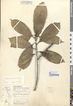
Lithocarpus aggregatus Barnett det. Luong Ngoc Toan at 05.1965
Collectors: Luong Ngoc Toan Field collecting number: N2-57. Collection date: 21.04.1964. Administrative regions: VN - Tinh Lao Cai. Groups of specimens: L. V. Averyanov specimens; L. V. Averyanov herbarium; Соглашение Минобрнауки №075-15-2021-1056; Flora of VietnamOriginal label text:FLORA OF VIETNAM
Record creation: 2024-03-29, Galina Savich, PhotoScan D2.. Processing status: work_status_1Citation: Specimen LE 01254299 // Virtual herbarium of Komarov Botanical Institute RAS — http://re.herbariumle.ru/01254299Fagaceae
Lithocarpus aggregatus Barnett.
Lao Cai Prov.
N 2-57, 21.04.1964
Det. Luong Ngoc Toan 05.1965
LE 01254300
Lithocarpus aggregatus Barnett det. Luong Ngoc Toan at 05.1965
Collectors: Luong Ngoc Toan Field collecting number: N2-57. Collection date: 21.04.1964. Administrative regions: VN - Tinh Lao Cai. Groups of specimens: L. V. Averyanov specimens; L. V. Averyanov herbarium; Соглашение Минобрнауки №075-15-2021-1056; Flora of VietnamOriginal label text:FLORA OF VIETNAM
Record creation: 2024-03-29, Galina Savich, PhotoScan D2.. Processing status: work_status_1Citation: Specimen LE 01254300 // Virtual herbarium of Komarov Botanical Institute RAS — http://re.herbariumle.ru/01254300Fagaceae
Lithocarpus aggregatus Barnett.
Lao Cai Prov.
N 2-57, 21.04.1964
Det. Luong Ngoc Toan 05.1965
LE 01254301
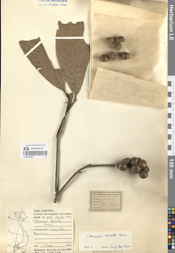
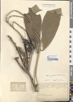
Lithocarpus bonnetii (Hickel & A.Camus) A.Camus. det. Luong Ngoc Toan at 05.1965
Collectors: Luong Ngoc Toan Field collecting number: N4357. Collection date: 16.03.1962. Administrative regions: VN - Tinh Lang Son. Groups of specimens: L. V. Averyanov specimens; L. V. Averyanov herbarium; Соглашение Минобрнауки №075-15-2021-1056; Flora of VietnamOriginal label text:FLORA OF VIETNAM
Record creation: 2024-03-29, Galina Savich, PhotoScan D2.. Processing status: work_status_1Citation: Specimen LE 01254301 // Virtual herbarium of Komarov Botanical Institute RAS — http://re.herbariumle.ru/01254301Fagaceae
Lithocarpus bonnetii (Hickel & A.Camus) A.Camus.
Lang Son Prov.
N 4357, 16.03.1962
Det. Luong Ngoc Toan 05.1965
LE 01254302
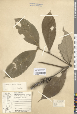
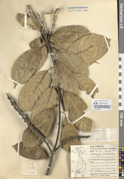
Lithocarpus bonnetii (Hickel & A.Camus) A.Camus. det. Luong Ngoc Toan at 1965
Collectors: Luong Ngoc Toan Field collecting number: N102. Collection date: 10.10.1960. Administrative regions: VN - Vietnam. Groups of specimens: L. V. Averyanov specimens; L. V. Averyanov herbarium; Соглашение Минобрнауки №075-15-2021-1056; Flora of VietnamOriginal label text:FLORA OF VIETNAM
Record creation: 2024-03-29, Galina Savich, PhotoScan D2.. Processing status: work_status_1Citation: Specimen LE 01254302 // Virtual herbarium of Komarov Botanical Institute RAS — http://re.herbariumle.ru/01254302Fagaceae
Lithocarpus bonnetii (Hickel & A.Camus) A.Camus.
Vietnam.
N 102, 10.10.1960
Det. Luong Ngoc Toan 1965
LE 01254303
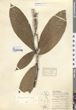
Lithocarpus bonnetii (Hickel & A.Camus) A.Camus. det. Luong Ngoc Toan at 1965
Collectors: Luong Ngoc Toan Field collecting number: N4375. Collection date: 16.03.1962. Administrative regions: VN - Tinh Lang Son. Groups of specimens: L. V. Averyanov specimens; L. V. Averyanov herbarium; Соглашение Минобрнауки №075-15-2021-1056; Flora of VietnamOriginal label text:FLORA OF VIETNAM
Record creation: 2024-03-29, Galina Savich, PhotoScan D2.. Processing status: work_status_1Citation: Specimen LE 01254303 // Virtual herbarium of Komarov Botanical Institute RAS — http://re.herbariumle.ru/01254303Fagaceae
Lithocarpus bonnetii (Hickel & A.Camus) A.Camus.
Lang Son Prov.
N 4375, 16.03.1962
Det. Luong Ngoc Toan 1965
LE 01254304
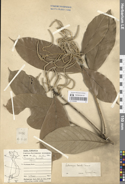
Lithocarpus bonnetii (Hickel & A.Camus) A.Camus. det. Luong Ngoc Toan at 1965
Collectors: Luong Ngoc Toan Field collecting number: N102. Collection date: 10.10.1960. Administrative regions: VN - Vietnam. Groups of specimens: L. V. Averyanov specimens; L. V. Averyanov herbarium; Соглашение Минобрнауки №075-15-2021-1056; Flora of VietnamOriginal label text:FLORA OF VIETNAM
Record creation: 2024-03-29, Galina Savich, PhotoScan D2.. Processing status: work_status_1Citation: Specimen LE 01254304 // Virtual herbarium of Komarov Botanical Institute RAS — http://re.herbariumle.ru/01254304Fagaceae
Lithocarpus bonnetii (Hickel & A.Camus) A.Camus.
Vietnam.
N 102, 10.10.1960
Det. Luong Ngoc Toan 1965
LE 01254305
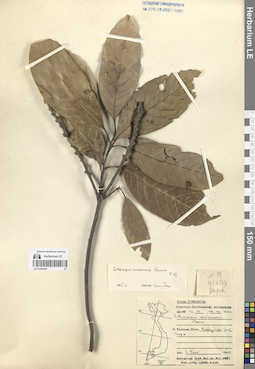
Lithocarpus annamensis (Hickel & A.Camus) Barnett. det. Luong Ngoc Toan at 05.1965
Collectors: Luong Ngoc Toan Field collecting number: N019. Collection date: 04.06.1963. Administrative regions: VN - Tinh Lao Cai. Groups of specimens: L. V. Averyanov specimens; L. V. Averyanov herbarium; Соглашение Минобрнауки №075-15-2021-1056; Flora of VietnamOriginal label text:FLORA OF VIETNAM
Record creation: 2024-03-29, Galina Savich, PhotoScan D2.. Processing status: work_status_1Citation: Specimen LE 01254305 // Virtual herbarium of Komarov Botanical Institute RAS — http://re.herbariumle.ru/01254305Fagaceae
Lithocarpus annamensis (Hickel & A.Camus) Barnett.
Lao Cai Prov.
N 019 ,04.06.1963
Det. Luong Ngoc Toan 05.1965
LE 01254306
Lithocarpus annamensis (Hickel & A.Camus) Barnett. det. Luong Ngoc Toan at 05.1965
Collectors: Luong Ngoc Toan Field collecting number: N019. Collection date: 04.06.1963. Administrative regions: VN - Tinh Lao Cai. Groups of specimens: L. V. Averyanov specimens; L. V. Averyanov herbarium; Соглашение Минобрнауки №075-15-2021-1056; Flora of VietnamOriginal label text:FLORA OF VIETNAM
Record creation: 2024-03-29, Galina Savich, PhotoScan D2.. Processing status: work_status_1Citation: Specimen LE 01254306 // Virtual herbarium of Komarov Botanical Institute RAS — http://re.herbariumle.ru/01254306Fagaceae
Lithocarpus annamensis (Hickel & A.Camus) Barnett.
Lao Cai Prov.
N 019 ,04.06.1963
Det. Luong Ngoc Toan 05.1965
LE 01254307
Lithocarpus bonnetii (Hickel & A.Camus) A.Camus. det. Luong Ngoc Toan at 05.1965
Collectors: Unknown Field collecting number: N4766. Collection date: 29.11.1961. Administrative regions: VN - Vietnam. Groups of specimens: L. V. Averyanov specimens; L. V. Averyanov herbarium; Соглашение Минобрнауки №075-15-2021-1056; Flora of VietnamOriginal label text:FLORA OF VIETNAM
Record creation: 2024-03-29, Galina Savich, PhotoScan D2.. Processing status: work_status_1Citation: Specimen LE 01254307 // Virtual herbarium of Komarov Botanical Institute RAS — http://re.herbariumle.ru/01254307Fagaceae
Lithocarpus bonnetii (Hickel & A.Camus) A.Camus.
Vietnam.
N 4766, 29.11.1961
Det. Luong Ngoc Toan 05.1965
LE 01254308
Lithocarpus annamensis (Hickel & A.Camus) Barnett. det. Luong Ngoc Toan at 05.1965
Collectors: Luong Ngoc Toan Field collecting number: N019. Collection date: 04.06.1963. Administrative regions: VN - Tinh Lao Cai. Groups of specimens: L. V. Averyanov specimens; L. V. Averyanov herbarium; Соглашение Минобрнауки №075-15-2021-1056; Flora of VietnamOriginal label text:FLORA OF VIETNAM
Record creation: 2024-03-29, Galina Savich, PhotoScan D2.. Processing status: work_status_1Citation: Specimen LE 01254308 // Virtual herbarium of Komarov Botanical Institute RAS — http://re.herbariumle.ru/01254308Fagaceae
Lithocarpus annamensis (Hickel & A.Camus) Barnett.
Lao Cai Prov.
N 019 ,04.06.1963
Det. Luong Ngoc Toan 05.1965