View
Add
Copy
Edit
Delete
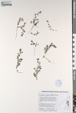
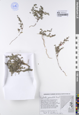
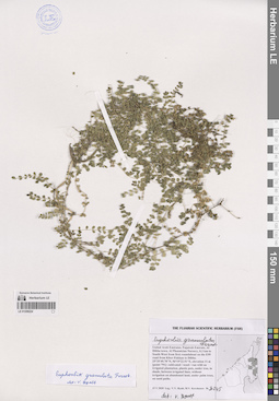
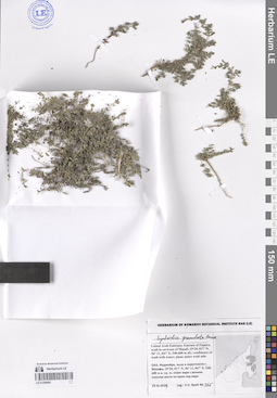
LE 01193961
Euphorbia granulata Forssk. det. Geltman, Dmitri Victorovich
Collectors: Byalt, Vyacheslav Vyacheslavovich; Korshunov, Mikhail Vladimirovich Field collecting number: 1416. Collection date: 22.11.2019. Administrative regions: AE - United Arab Emirates. Place of collection: Фуджейра, пос. Авала, сорняк во дворе форта Ахвала.Groups of specimens: Образцы общего сектора; Соглашение Минобрнауки №075-15-2021-1056; Бялт В.В.: Флора ФуджейрыOriginal label text: United Arab Emirates. Emirate of Fujaira, vil. Ahwala, 24°54'31.11"N 56°18'11.596"E, ca. 80 m alt.: weed in the yard of Ahwala Fort. – ОАЭ, Фуджейра, пос. Авала, 24 ° 54'31,11 "N 56 ° 18'11,596" E, ок. 80 м н.ур.м.: сорняк во дворе форта Ахвала, 22 XI 2019,fl., fr., V.V. Byalt, M.V. Korshunov 1416
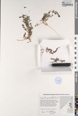
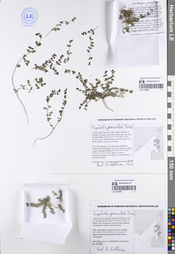
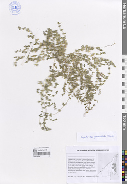
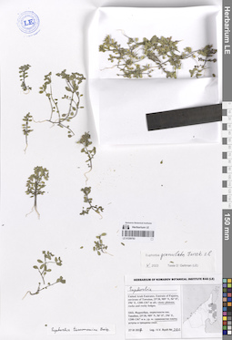
LE 01194039
Euphorbia granulata Forssk. det. Geltman, Dmitri Victorovich at 2021
Collectors: Byalt, Vyacheslav Vyacheslavovich; Korshunov, Mikhail Vladimirovich Field collecting number: s.n.. Collection date: 04.04.2020. Administrative regions: AE - United Arab Emirates. Place of collection: Fujairah Emirate, Masafi friday market, E88 Al Dhaid – Masafi road, 5.2 km to Masafi [point 732]: weed/cultivated in plant market and plant nursery; in garden; on household trash.Groups of specimens: Образцы общего сектора; Соглашение Минобрнауки №075-15-2021-1056; Бялт В.В.: Флора ФуджейрыOriginal label text: United Arab Emirates, Fujairah Emirate, Masafi friday market, E88 Al Dhaid – Masafi road, 5.2 km to Masafi.
25°17'28.28"N, 56° 6'48.62"E, elevation 370 m. [point 732]: weed/cultivated in plant market and plant nursery; in garden; on houshold trash, 3 IV 2020, V.V. Byalt, M.V. Korshunov
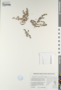
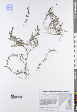
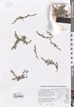
LE 01194157
Euphorbia granulata Forssk. det. Byalt, Vyacheslav Vyacheslavovich
Administrative regions: AE - United Arab Emirates. Groups of specimens: Образцы общего сектора; Соглашение Минобрнауки №075-15-2021-1056Record creation: 2023-05-12, Larisa Orlova, PhotoScan D2. Part 1.Citation: Specimen LE 01194157 // Virtual herbarium of Komarov Botanical Institute RAS — http://re.herbariumle.ru/01194157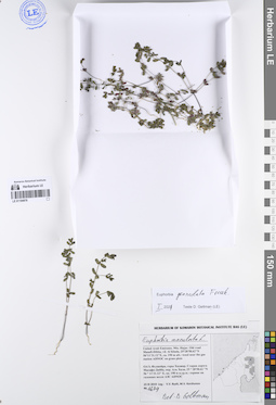
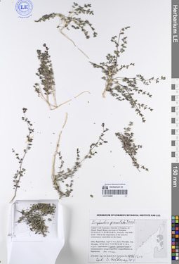
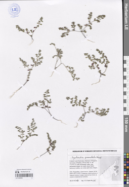
LE 01194878
Euphorbia granulata Forssk. det. Geltman, Dmitri Victorovich at 01.2021
Additional identifications: Euphorbia maculata L. det. Geltman, Dmitri Victorovich Collectors: Byalt, Vyacheslav Vyacheslavovich; Korshunov, Mikhail Vladimirovich Field collecting number: 1679. Collection date: 23.11.2019. Administrative regions: AE - United Arab Emirates. Place of collection: Фуджейра, горы Хаджар, старая дорога Масафи-Дибба, окрестности пос. Аль Хала, сорное возле АЗС ADNOC на газонах.Groups of specimens: Образцы общего сектора; Соглашение Минобрнауки №075-15-2021-1056; Бялт В.В.: Флора ФуджейрыOriginal label text: United Arab Emirates. Mts. Hajar. Old road Masafi-Dibba, vil. Al Khala, 25°28'58.62"N 56°11'31.12"E, ca. 190 m alt.: weeds near the gas station ADNOC on grass plots.– ОАЭ, Фуджейра, горы Хаджар. Старая дорога Масафи-Дибба, окр. Аль Хала, 25 ° 28'58.62 "N 56 ° 11'31.12" E, ок. 190 м н.ур.м.: сорняк возле АЗС ADNOC на газоннах, 23 XI 2019 V.V. Byalt, M.V. Korshunov 1679
LE 01194879
Euphorbia granulata Forssk. det. Geltman, Dmitri Victorovich at 2021
Collectors: Byalt, Vyacheslav Vyacheslavovich; Korshunov, Mikhail Vladimirovich Field collecting number: s.n. Collection date: 06.04.2020. Administrative regions: AE - United Arab Emirates. Place of collection: Fujairah emirate, wadi Al Sahm, 5.4 km from E84 road (Maleha-Fujairah), 4.2 km straight North-West from Al Hail Castle (Al Hail Fort). Small wadi to mountain apex [point 739]: in stone wadi; gravel wadi; mountain sides, among stones and rocks on sides.Groups of specimens: Образцы общего сектора; Соглашение Минобрнауки №075-15-2021-1056; Бялт В.В.: Флора ФуджейрыOriginal label text: United Arab Emirates, Fujairah emirate, wadi Al Sahm, 5.4 km from E84 road (Maleha-Fujairah), 4.2 km straight North-West from Al Hail Castle (Al Hail Fort). Small wadi to mountain apex.
25° 6'10.20"N, 56°11'36.18"E, elevation 400–550 m. [point 739]: in stone wadi; gravel wadi; mountain sides, among stones and rocks on sides, 6 IV 2020, V.V. Byalt, M.V. Korshunov s.n

LE 01194880
Euphorbia granulata Forssk. det. Geltman, Dmitri Victorovich at 2021
Collectors: Byalt, Vyacheslav Vyacheslavovich; Korshunov, Mikhail Vladimirovich Field collecting number: 1546. Collection date: 23.11.2019. Administrative regions: AE - United Arab Emirates. Place of collection: Фуджейра, горы Хаджар, граница эмиратов Фуджейра и Рас-эль-Хайма, старая дорога Масафи-Дибба, на дне и боковых склонах вади; на скалах и в каменистом сухом водотоке.Groups of specimens: Образцы общего сектора; Соглашение Минобрнауки №075-15-2021-1056; Бялт В.В.: Флора ФуджейрыOriginal label text: United Arab Emirates. Mts. Hajar. Border of emirate of Fujaira and Ras al Khaima, old road Masafi-Dibba, 25°21'17.57"N 56°10'47.12"E, ca. 515 m alt.: on wadi bottom and side slopes; on rocks and in a stony dry stream.– ОАЭ, Фуджейра, горы Хаджар. Граница эмиратов Фуджейра и Рас-эль-Хайма, старая дорога Масафи-Дибба, 25 ° 21'17.57 "N 56 ° 10'47.12" E, ок. 515 м.: на дне и боковых склонах вади; на скалах и в каменистом сухом водотоке, 23 XI 2019, V.V. Byalt, M.V. Korshunov 1546 Det. D. Geltman, 2021
LE 01194881
Euphorbia granulata Forssk. det. Geltman, Dmitri Victorovich
Collectors: Byalt, Vyacheslav Vyacheslavovich; Korshunov, Mikhail Vladimirovich Field collecting number: 1796. Collection date: 28.11.2019. Administrative regions: AE - United Arab Emirates. Place of collection: Фуджейра, окрестности пос. Мерба [точка 349]: зарастающий просописом Prosopis sp. пустырь (местами с солянками Salsola sp.).Groups of specimens: Образцы общего сектора; Соглашение Минобрнауки №075-15-2021-1056; Бялт В.В.: Флора ФуджейрыOriginal label text: United Arab Emirates. Emirate of Fujaira, env. of vill. Mirbah, 25°15'41.67"N 56°21'29.11"E [point 349]: overgrown with Prosopis juliflora wasteland (in places with saltwarts).– ОАЭ, Фуджейра, окресности пос. Мерба, 25°15'41.67"N 56°21'29.11"E [точка 349]: зарастающий просописом пустырь (местами с солянками), 28 XI 2019 V.V. Byalt & M.V. Korshunov 1796 Det. D. Geltman
LE 01194882
Euphorbia granulata Forssk. det. Geltman, Dmitri Victorovich
Collectors: Byalt, Vyacheslav Vyacheslavovich; Korshunov, Mikhail Vladimirovich Field collecting number: 1608. Collection date: 01.04.2020. Administrative regions: AE - United Arab Emirates. Place of collection: Fujairah Emirate, Al Siji, wadi Siji, 3.1 km East from Wadi Siji Old Dam, 3.6 km South from Masafi Friday Market Sur (plant market 4.8 km from Masafi by E88 road) [730]: in gravel-stony wadi; on stone-gravel wadi banks; in sand wadi.Groups of specimens: Образцы общего сектора; Соглашение Минобрнауки №075-15-2021-1056; Бялт В.В.: Флора ФуджейрыOriginal label text: United Arab Emirates, Fujairah Emirate, Al Siji, wadi Siji, 3.1 km East from Wadi Siji Old Dam, 3.6 km South from Masafi Friday Market Sur (plant market 4.8 km from Masafi by E88 road). 25°15'33.84"N, 56° 6'30.33"E, elevation 314 m. [730]: in gravel-stony wadi; on stone-gravel wadi banks; in sand wadi, 1 IV 2020, V.V. Byalt, M.V. Korshunov 1608 Det. D. Geltman
LE 01194883
Euphorbia granulata Forssk. det. Geltman, Dmitri Victorovich at 2021
Collectors: Byalt, Vyacheslav Vyacheslavovich; Korshunov, Mikhail Vladimirovich Field collecting number: 1896/614. Collection date: 29.11.2019. Administrative regions: AE - United Arab Emirates. Place of collection: Фуджейра, дорога Аль Даид-Мазафи, окрестности г. Манама, дикорастущее в понижении в конце водотока с водосбором на барханах, на песке.Groups of specimens: Образцы общего сектора; Соглашение Минобрнауки №075-15-2021-1056; Бялт В.В.: Флора ФуджейрыOriginal label text: United Arab Emirates. Emirate of Fujaira, Al Dhaid-Masafi Road, environs of Manama, 25°36'10.31"N 55°58'25.48"E, 26 m alt.: wild in the depression at the end of a watercourse watershed on the dunes, – ОАЭ, Фуджейра, дорога Аль Даид-Мазафи, окр. Манама, 25°36'10.31"N 55°58'25.48"E, 26 м н.ур.м.: дикорастущее в понижении в конце водотока с водосбором на барханах, на песке, 29 XI 2019 V.V. Byalt & M.V. Korshunov 1896/614 Det. D. Geltman
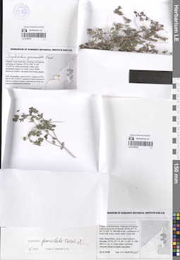
LE 01259224
Euphorbia granulata Forssk. det. Byalt, Vyacheslav Vyacheslavovich
Collectors: Byalt, Vyacheslav Vyacheslavovich; Korshunov, Mikhail Vladimirovich Field collecting number: 3245. Collection date: 15.05.2020. Administrative regions: AE - United Arab Emirates. Place of collection: Fujairah Emirate, Al Dibba town, Al Phoenician Nursery, 0.3 km to South-West from first roundabout on the E99 road from Khorfakkan to Dibba [point 791]: common weed under palm trees, on sand paths.Groups of specimens: Образцы общего сектора; Соглашение Минобрнауки №075-15-2021-1056; Бялт В.В.: Флора ФуджейрыOriginal label text: United Arab Emirates, Fujairah Emirate, Al Dibba town, Al Phoenician Nursery, 0.3 km to South-West from first roundabout on the E99 road from Khorfakkan to Dibba. 25°35'49.78"N, 56°19'22.51"E, elevation 11 m [point 791]: common weed under palm trees, on sand paths, 26 V 2020, fl., fr., V.V. Byalt, M.V. Korshunov 3245
LE 01259566
Euphorbia granulata Forssk. det. Byalt, Vyacheslav Vyacheslavovich
Collectors: Byalt, Vyacheslav Vyacheslavovich; Korshunov, Mikhail Vladimirovich Field collecting number: 3500. Collection date: 08.06.2020. Administrative regions: AE - United Arab Emirates. Place of collection: Fujairah Emirate, Al Dibba town, The Green Nursery Sales Dibba, 0.2 km South from Khalid Hadi Resort Dibba [point 795]: weed on irrigated plantation under palm trees.Groups of specimens: Образцы общего сектора; Соглашение Минобрнауки №075-15-2021-1056; The Fujairah Scientific Herbarium (FSH); Бялт В.В.: Флора ФуджейрыOriginal label text: United Arab Emirates, Fujairah Emirate, Al Dibba town, The Green Nursery Sales Dibba, 0.2 km South from Khalid Hadi Resort Dibba. 25°34'29.81"N, 56°14'16.32"E, elevation 44 m [point 795]: weed on irrigated plantation under palm trees. 8 VI 2020, V.V. Byalt, M.V. Korshunov 3500
LE 01259781
Euphorbia granulata var. glabrata (J.Gay) Boiss. det. Byalt, Vyacheslav Vyacheslavovich
Collectors: Byalt, Vyacheslav Vyacheslavovich Field collecting number: 87. Collection date: 22.03.2017. Administrative regions: AE - United Arab Emirates. Place of collection: Фуджейра, Вади Вурайа Национальный парк, в 8 км северо-западнее г. Хор Факкан, огороженные загоны для таров в горах: в низине; на каменистом склоне; низинки с песком среди каменных полей (с поливом).Groups of specimens: Образцы общего сектора; Соглашение Минобрнауки №075-15-2021-1056; Бялт В.В.: Флора ФуджейрыOriginal label text: United Arab Emirates. Emirate of Fujaira, Wadi Wurayah National Park, 8 km NW from Khor Fakkan, ca. 25°23’ N, 56° 18’ E, ca. 160–170 m alt., fenced paddocks for tar in the mountains: in the hollow; on gravelly slopes; the hollows with sand among the stone fields (with irrigation). – ОАЭ, Фуджейра, Вади Вурайа Национальный парк, в 8 км к СЗ от г. Хор Факкан, ca. 25°23’ N, 56° 18’ E, огороженные загоны для таров в горах: в низине; на каменистом склоне; низинки с песком среди каменных полей (с поливом), 22 III 2017, V.V. Byalt 87
LE 01259782
Euphorbia granulata Forssk. det. Byalt, Vyacheslav Vyacheslavovich
Collectors: Byalt, Vyacheslav Vyacheslavovich Field collecting number: 245. Collection date: 26.03.2017. Administrative regions: AE - United Arab Emirates. Place of collection: Фуджейра, окрестности г. Дадна, широкая горная долина и горные склоны: скалы и каменистые склоны северо-западной экспозиции.Groups of specimens: Образцы общего сектора; Соглашение Минобрнауки №075-15-2021-1056; Бялт В.В.: Флора ФуджейрыOriginal label text: United Arab Emirates. Emirate of Fujaira, environs of Dadna, 25°24, 018’ N, 56° 17,475’ E: wide mountain valley and mountain slopeson rocks and stony slopes NW exp. Фуджейра, окрестности г. Дадна, 25°24, 018’ N, 56° 17,475’ E: широкая горная долина и горные склоны: на скалах и каменистых склонах NW эксп., 26-27 III 2017, fl., Byalt 245
LE 01259783
Euphorbia granulata Forssk. ⟮s. l.⟯ det. Geltman, Dmitri Victorovich at 05.2023
Additional identifications: Euphorbia sp. det. Byalt, Vyacheslav Vyacheslavovich; Euphorbia turcomanica Boiss. det. Byalt, Vyacheslav Vyacheslavovich Collectors: Byalt, Vyacheslav Vyacheslavovich Field collecting number: 322. Collection date: 27.03.2017. Administrative regions: AE - United Arab Emirates. Place of collection: Фуджейра, окрестности пос. Тавайан, каменистое плато.Groups of specimens: Образцы общего сектора; Соглашение Минобрнауки №075-15-2021-1056; Бялт В.В.: Флора ФуджейрыOriginal label text: United Arab Emirates. Emirate of Fujaira, environs of Tawaian, 25°38, 989’ N, 56° 07, 296’ E, 1200–1367 m alt.: stony plateau. – ОАЭ, Фуджейра, окрестности пос. Тавайан, 25°38, 989’ N, 56° 07, 296’ E, 1200–1367 м н. ур. м.: каменистое плото, 27 III 2017, V.V. Byalt 322

LE 01259787
Euphorbia granulata Forssk. det. Byalt, Vyacheslav Vyacheslavovich
Collectors: Byalt, Vyacheslav Vyacheslavovich Field collecting number: 252. Collection date: 26.03.2017. Administrative regions: AE - United Arab Emirates. Place of collection: Фуджейра, окрестности г. Дадна, широкая горная долина и горные склоны: каменистые поля в вади.Groups of specimens: Образцы общего сектора; Соглашение Минобрнауки №075-15-2021-1056; Бялт В.В.: Флора ФуджейрыOriginal label text: United Arab Emirates. Emirate of Fujaira, environs of Dadna, 25°24, 018’ N, 56° 17,475’ E: wide mountain valley and mountain slopes: in wadi; stony fields between wadies. – ОАЭ, Фуджейра, окрестности г. Дадна, 25°24, 018’ N, 56° 17,475’ E: широкая горная долина и горные склоны: в вади; каменистые поля. 26-27 III 2017, V.V. Byalt 252
LE 01259788
Euphorbia granulata Forssk. ⟮s. l.⟯ det. Geltman, Dmitri Victorovich at 05.2023
Collectors: Byalt, Vyacheslav Vyacheslavovich Field collecting number: 425. Collection date: 29.03.2017. Administrative regions: AE - United Arab Emirates. Place of collection: Фуджейра, вади в окрестности пос. Мазафи, плоские места по краю над вади.Groups of specimens: Образцы общего сектора; Соглашение Минобрнауки №075-15-2021-1056; Бялт В.В.: Флора ФуджейрыOriginal label text: United Arab Emirates. Emirate of Fujaira, wadi in environs of Masafi, 25°20, 017’ N, 56° 11, 847’ E, 540–600 m alt.: plane under wadi side.– ОАЭ, Фуджейра, вади в окрестности г. Мазафи, 25°20, 017’ N, 56° 11, 847’ E, 540–600 м н. ур. м.: плоские места по краю над вади, 29 III 2017, V.V. Byalt 425
LE 01259800
Euphorbia granulata Forssk. det. Byalt, Vyacheslav Vyacheslavovich
Collectors: Byalt, Vyacheslav Vyacheslavovich Field collecting number: 425. Collection date: 29.03.2017. Administrative regions: AE - United Arab Emirates. Place of collection: Фуджейра, вади в окрестности пос. Мазафи, отрог вади с ручьем; плоские места по краю над вади.Groups of specimens: Образцы общего сектора; Соглашение Минобрнауки №075-15-2021-1056; Бялт В.В.: Флора ФуджейрыOriginal label text: United Arab Emirates. Emirate of Fujaira, wadi in environs of Masafi, 25°20, 017’ N, 56° 11, 847’ E, 540–600 m alt.: confluence of wadi with water; plane under wadi side.– ОАЭ, Фуджейра, вади в окрестности г. Мазафи, 25°20, 017’ N, 56° 11, 847’ E, 540–600 м н. ур. м.: отрог вади с ручьем; плоские места по краю над вади, 29 III 2017, V.V. Byalt 425