View
Add
Copy
Edit
Delete
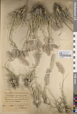
LE 01240324
Enneapogon persicus Boiss. det. Tzvelev, Nikolai Nikolaievich at 1956
Collectors: Egorova, Tatiana Vladimirovna; Tzvelev, Nikolai Nikolaievich; Czerepanov, Sergei Kirillovich Field collecting number: 1364. Collection date: 28.06.1956. Administrative regions: AM - Syunik'i Marz. Place of collection: нижний горный пояс, каменистый склон горы в 1 км севернее г. Мегри.Groups of specimens: Образцы сектора Восточной Европы; Соглашение Минобрнауки №075-15-2021-1056; Herbarium Instituti Botanici Academiae Sc. URSSOriginal label text:Herbarium Instituti Botanici Academiae Sc. URSS. Enneapogon persicus Boiss. Армянская ССР. Мегринский р-н. Нижн. горн. пояс. Каменистый склон горы в 1 км к сев. от гор. Мегри. 28 1956 VI. № 1364. Собр. Т.В. Егорова, Н.Н. Цвелев С.К. Черепанов. Опред. Н. Цвелев
Landscape in location of collection: нижний горный пояс, каменистый склон горыCoordinates (geographic position): 38° 55′ 15.41″ N, 46° 14′ 41.2″ E ±200 mRecord creation: 2023-07-05, Artyom Borodushkin, PhotoScan D2.Citation: Specimen LE 01240324 // Virtual herbarium of Komarov Botanical Institute RAS — http://re.herbariumle.ru/01240324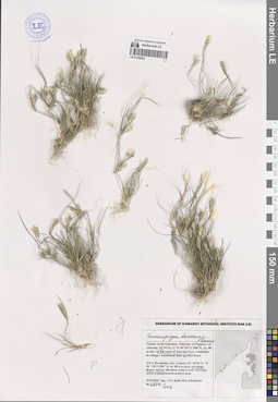
LE 01259202
Enneapogon desvauxii Beauv. det. Byalt, Vyacheslav Vyacheslavovich
Collectors: Byalt, Vyacheslav Vyacheslavovich; Korshunov, Mikhail Vladimirovich Field collecting number: 1422/100. Collection date: 22.11.2019. Administrative regions: AE - United Arab Emirates. Place of collection: Фуджейра, пос. Авала, двор форта Ахвала.Groups of specimens: Образцы общего сектора; Соглашение Минобрнауки №075-15-2021-1056; Бялт В.В.: Флора ФуджейрыOriginal label text: United Arab Emirates. Emirate of Fujaira, vil. Ahwala, 24°54'31.11"N 56°18'11.596"E, ca. 80 m alt.: in the yard of Ahwala Fort. – ОАЭ, Фуджейра, пос. Авала, 24 ° 54'31,11 "N 56 ° 18'11,596" E, ок. 80 м н.ур.м.: во дворе форта Ахвала, 22 XI 2019, fl., fr.,
V.V. Byalt, M.V. Korshunov 1422/100
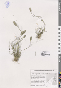
LE 01259217
Enneapogon desvauxii Beauv. det. Byalt, Vyacheslav Vyacheslavovich
Collectors: Byalt, Vyacheslav Vyacheslavovich; Korshunov, Mikhail Vladimirovich Field collecting number: 1514/192. Collection date: 23.11.2019. Administrative regions: AE - United Arab Emirates. Place of collection: Фуджейра, горы Хаджар. Граница эмиратов Фуджейра и Рас-эль-Хайма, старая дорога Масафи-Дибба, вади: на дне.Groups of specimens: Образцы общего сектора; Соглашение Минобрнауки №075-15-2021-1056; Бялт В.В.: Флора ФуджейрыOriginal label text: United Arab Emirates. Mts. Hajar. Border of emirate of Fujaira and Ras al Khaima, old road Masafi-Dibba, 25°21'17.57"N 56°10'47.12"E, ca. 515 m alt.: on wadi bottom.– ОАЭ, Фуджейра, горы Хаджар. Граница эмиратов Фуджейра и Рас-эль-Хайма, старая дорога Масафи-Дибба, 25 ° 21'17.57 "N 56 ° 10'47.12" E, ок. 515 м. Вади: на дне, 23 XI 2019, fl., V.V. Byalt, M.V. Korshunov 1514/192
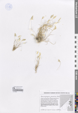
LE 01259453
Enneapogon persicus Boiss. det. Byalt, Vyacheslav Vyacheslavovich
Collectors: Byalt, Vyacheslav Vyacheslavovich; Korshunov, Mikhail Vladimirovich Field collecting number: 1013a. Collection date: 24.03.2020. Administrative regions: AE - United Arab Emirates. Place of collection: Fujairah Emirate, 0.6 km East-North-East to cell tower on the mountain peak, 3.5 km West to Ghub, 8 km West-South-West to Dibba [point 720]: on abandoned baghara (winter season dryland farm).Groups of specimens: Образцы общего сектора; Соглашение Минобрнауки №075-15-2021-1056; Бялт В.В.: Флора ФуджейрыOriginal label text: UAE, Fujairah emirate, 0.6 km East-North-East to cell tower on the mountain peak, 3.5 km West to Ghub, 8 km West-South-West to Dibba. 25°34'34.49"N, 56°10'6.31"E, elevation 730 m. [point 720]: on abandoned baghara (winter season dryland farm), 24 III 2020, fr., V.V. Byalt, M.V. Korshunov 1013a