View
Add
Copy
Edit
Delete

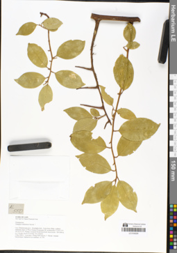
LE 00015383
Specimen originale of Elaeagnus moorcroftii Wall. ex Schltdl.
Place of collection: Shalbar.Groups of specimens: Образцы общего сектораComment:[Imported description]
Family: Elaeagnaceae
Taxon: Elaeagnus moorcroftii Wall.
Type specimen category: Original material
Collectors: Hb. Calerett
Locality: Shalbar
Family: Elaeagnaceae
Taxon: Elaeagnus moorcroftii Wall.
Type specimen category: Original material
Collectors: Hb. Calerett
Locality: Shalbar
LE 01048289
Elaeagnus tonkinensis Servett. ? det. Averyanov, Leonid Vladimirovich at 03.05.2018
Collectors: Averyanov, Leonid Vladimirovich; Khang Sinh Nguyen; Maisak, Tatiana Viktorovna; et al. Field collecting number: AL550. Collection date: 03.05.2018. Administrative regions: LA - Khammouan. Groups of specimens: L. V. Averyanov specimens; L. V. Averyanov herbarium; L. V. Averyanov photosOriginal label text:FLORA OF LAOS Hin Nam No Nature Protected Area Elaeagnaceae Elaeagnus tonkinensis Servett. ? Laos, Khammouane prov., Boualapha distr., Nong Seng village, southern sandstone slopes of Phou Chuang (Poujeuang) Mt. around point 17°34'13.3"N 105°47'57.5"E. Primary evergreen broad-leaved dry forest at elev. 700-1000 m a.s.l. Woody vine 8-12 m long. Not common. 3 May 2018, L. Averyanov, Khang Sinh Nguyen, T. Maisak, Littideth Xaiyavongsa, Siphanom Keovankham, AL 550.
Coordinates (geographic position): 17° 34′ 13.3″ N, 105° 47′ 57.5″ E ±1000 mRecord creation: 2019-01-19, Leonid Averyanov, PhotoScan D1Citation: Specimen LE 01048289 // Virtual herbarium of Komarov Botanical Institute RAS — http://re.herbariumle.ru/01048289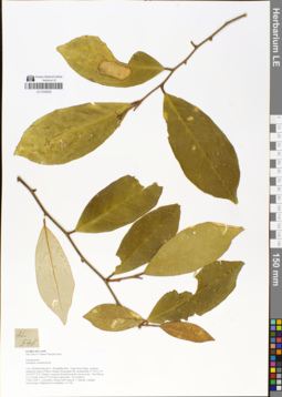
LE 01048293
Elaeagnus conferta Roxb. det. Averyanov, Leonid Vladimirovich at 03.05.2018
Collectors: Averyanov, Leonid Vladimirovich; Khang Sinh Nguyen; Maisak, Tatiana Viktorovna; et al. Field collecting number: AL546. Collection date: 03.05.2018. Administrative regions: LA - Khammouan. Groups of specimens: L. V. Averyanov specimens; L. V. Averyanov herbarium; L. V. Averyanov photosOriginal label text:FLORA OF LAOS Hin Nam No Nature Protected Area Elaeagnaceae Elaeagnus conferta Roxb. Laos, Khammouane prov., Boualapha distr., Nong Seng village, southern sandstone slopes of Phou Chuang (Poujeuang) Mt. around point 17°34'13.3"N 105°47'57.5"E. Primary evergreen broad-leaved dry forest at elev. 700-1000 m a.s.l. Woody vine to 15 m long in open place. Not common. 3 May 2018, L. Averyanov, Khang Sinh Nguyen, T. Maisak, Littideth Xaiyavongsa, Siphanom Keovankham, AL 546.
Coordinates (geographic position): 17° 34′ 13.3″ N, 105° 47′ 57.5″ E ±1000 mRecord creation: 2019-01-19, Leonid Averyanov, PhotoScan D1Citation: Specimen LE 01048293 // Virtual herbarium of Komarov Botanical Institute RAS — http://re.herbariumle.ru/01048293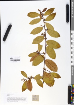
LE 01049037
Elaeagnus difficilis Serv. det. Averyanov, Leonid Vladimirovich at 13.09.2019
Additional identifications: Elaeagnus sp. det. Averyanov, Leonid Vladimirovich at 19.10.2018 Collectors: Averyanov, Leonid Vladimirovich; Khang Sinh Nguyen; Maisak, Tatiana Viktorovna; Truong Duc Thieu Field collecting number: VR1041. Collection date: 19.10.2018. Administrative regions: VN - Tinh Ha Giang. Groups of specimens: L. V. Averyanov specimens; L. V. Averyanov herbarium; L. V. Averyanov photosOriginal label text:FLORA OF VIETNAM
Coordinates (geographic position): 23° 3′ 0.4″ N, 104° 52′ 2.2″ E ±1000 mComment: Elaeagnaceae
Elaeagnus sp.
Ha Giang prov., Quan Ba distr., Tung Vai commune, Thang village, around point 23º03ʹ00.4ʺN 104º52ʹ02.2ʺE, steep rocky slopes of river valley composed with eroded limestone at elevation 1000–1060 m a.s.l. Remnants of primary evergreen broad-leaved very humid forest. Scandent shrub or woody vine to 10 m long on open shrubs along river. Flowers pale light yellow. Not common. 19 October 2018, L. Averyanov, Nguyen Sinh Khang, T. Maisak, Truong Quang Ngan, VR 1041.
All photos © L. Averyanov & K.S. Nguyen
Record creation: 2019-05-09, Leonid Averyanov, PhotoScan D1Citation: Specimen LE 01049037 // Virtual herbarium of Komarov Botanical Institute RAS — http://re.herbariumle.ru/01049037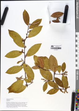
LE 01049077
Elaeagnus difficilis Serv. det. Averyanov, Leonid Vladimirovich at 13.09.2019
Additional identifications: Elaeagnus sp. det. Averyanov, Leonid Vladimirovich at 19.10.2018 Collectors: Averyanov, Leonid Vladimirovich; Khang Sinh Nguyen; Maisak, Tatiana Viktorovna; Truong Duc Thieu Field collecting number: VR1041. Collection date: 19.10.2018. Administrative regions: VN - Tinh Ha Giang. Groups of specimens: L. V. Averyanov specimens; L. V. Averyanov herbarium; L. V. Averyanov photosOriginal label text:FLORA OF VIETNAM Elaeagnaceae Elaeagnus sp. Ha Giang prov., Quan Ba distr., Tung Vai commune, Thang village, around point 23º03ʹ00.4ʺN 104º52ʹ02.2ʺE, steep rocky slopes of river valley composed with eroded limestone at elevation 1000–1060 m a.s.l. Remnants of primary evergreen broad-leaved very humid forest. Scandent shrub or woody vine to 10 m long on open shrubs along river. Flowers pale light yellow. Not common. 19 October 2018, L. Averyanov, Nguyen Sinh Khang, T. Maisak, Truong Quang Ngan, VR 1041.
Coordinates (geographic position): 23° 3′ 0.4″ N, 104° 52′ 2.2″ E ±1000 mComment: All photos © L. Averyanov & K.S. Nguyen
Record creation: 2019-05-09, Leonid Averyanov, PhotoScan D1Citation: Specimen LE 01049077 // Virtual herbarium of Komarov Botanical Institute RAS — http://re.herbariumle.ru/01049077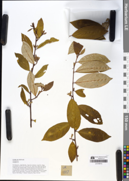
LE 01049112
Elaeagnus sarmentosa Rehder ⟮prelim. ID⟯ det. Averyanov, Leonid Vladimirovich at 13.09.2019
Additional identifications: Elaeagnus sp. det. Averyanov, Leonid Vladimirovich at 18.10.2018 Collectors: Averyanov, Leonid Vladimirovich; Khang Sinh Nguyen; Maisak, Tatiana Viktorovna; Truong Duc Thieu Field collecting number: VR1007. Collection date: 18.10.2018. Administrative regions: VN - Tinh Ha Giang. Groups of specimens: L. V. Averyanov specimens; L. V. Averyanov herbarium; L. V. Averyanov photosOriginal label text:FLORA OF VIETNAM
Coordinates (geographic position): 23° 2′ 55″ N, 104° 56′ 1.4″ E ±1000 mComment: Elaeagnaceae
Elaeagnus sp.
Ha Giang prov., Quan Ba distr., Tung Vai commune, Lung Kho village, around point 23º02ʹ55.0ʺN 104º56ʹ01.4ʺE, steep rocky slopes near hill top composed with stratified highly eroded limestone at elevation 900–980 m a.s.l. Remnants of primary evergreen broad-leaved very humid forest. Climbing shrub or woody vine to 10 m long in open place among secondary shrubs. Flowers dull yellow. Occasional. 18 October 2018, L. Averyanov, Nguyen Sinh Khang, T. Maisak, Truong Duc Thieu, VR 1007.
All photos © L. Averyanov & K.S. Nguyen
Record creation: 2019-05-09, Leonid Averyanov, PhotoScan D1Citation: Specimen LE 01049112 // Virtual herbarium of Komarov Botanical Institute RAS — http://re.herbariumle.ru/01049112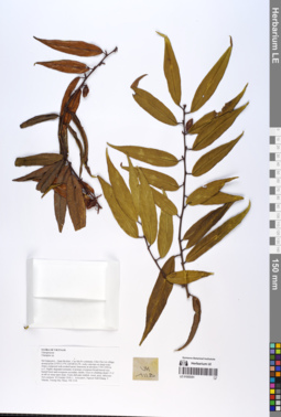
LE 01055351
Elaeagnus delavayi Lecomte ⟮prelim. ID⟯ det. Averyanov, Leonid Vladimirovich at 13.09.2019
Additional identifications: Elaeagnus sp. det. Averyanov, Leonid Vladimirovich at 20.10.2018 Collectors: Averyanov, Leonid Vladimirovich; Khang Sinh Nguyen; Maisak, Tatiana Viktorovna; Truong Duc Thieu Field collecting number: VR1118. Collection date: 20.10.2018. Administrative regions: VN - Tinh Ha Giang. Groups of specimens: L. V. Averyanov specimens; L. V. Averyanov photos; L. V. Averyanov herbariumOriginal label text:FLORA OF VIETNAM.
Coordinates (geographic position): 23° 5′ 13.5″ N, 104° 48′ 30.2″ E ±1000 mComment: Elaeagnaceae.
Elaeagnus sp.
Ha Giang prov., Quan Ba distr., Cao Ma Po commune, Chin Chu Lin village, around point 23º05ʹ13.5ʺN 104º48ʹ30.2ʺE, rocky outcrops on steep rocky slopes composed with eroded karstic limestone at elevation 1750–1950 m a.s.l. Highly degraded remnants of primary evergreen broad-leaved very humid forest and evergreen secondary shrubs. Erect or climbing shrub 1.5–2 m tall on steep open slope. Fruits dull pale reddish, sweet, juicy, delicious. Not common.20 October 2018, L. Averyanov, Nguyen Sinh Khang, T. Maisak, Truong Duc Thieu, VR 1118.
All photos © L. Averyanov & K.S. Nguyen
Record creation: 2019-06-11, Leonid Averyanov, PhotoScan D1Citation: Specimen LE 01055351 // Virtual herbarium of Komarov Botanical Institute RAS — http://re.herbariumle.ru/01055351