View
Add
Copy
Edit
Delete
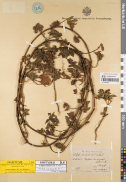
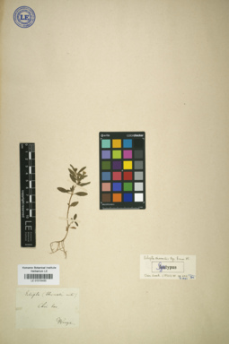
LE 01001598
Isotype of Eclipta dentata H. Lév. et Vaniot
Field collecting number: 1038. Collection date: 10.09.1908. Administrative regions: KR - Korea (Republic of). Place of collection: Quelpaert, in arenosis littoris E..Groups of specimens: Образцы сектора Центральной и Восточной Азии; Типовые образцы сектора Центральной и Восточной АзииComment:[Imported description]
Taxon: Eclipta dentata H. Lév. et Vaniot
Type specimen category: Isotypus
Original paper: Bull. Acad. Geogr. Bot. 20 : 11 (1910)
Collectors: E. Taquet
Record number: 1038
Collection date: 1908.09.10
Country: Korea
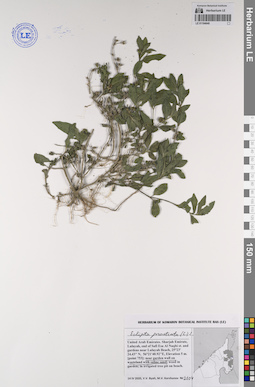
LE 01008334
Eclipta prostrata (L.) L.
Field collecting number: 238. Collection date: 10.1907. Administrative regions: KR - Korea (Republic of). Place of collection: in humidis et fossis Quelpaert.Groups of specimens: Образцы сектора Центральной и Восточной АзииComment:[Imported description]
Taxon: Eclipta prostrata (L.) L.
Type specimen category: General specimen
Collectors: E. Taquet
Record number: 238
Collection date: 1907.10
Country: Korea
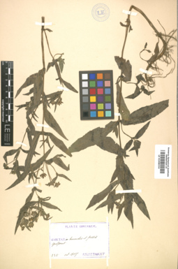
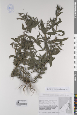
LE 01008335
Eclipta prostrata (L.) L.
Collection date: 07.1902. Administrative regions: KR - Korea (Republic of). Place of collection: inter Chemulpo et Seoul.Groups of specimens: Образцы сектора Центральной и Восточной АзииComment:[Imported description]
Taxon: Eclipta prostrata (L.) L.
Type specimen category: General specimen
Collectors: M. Wassiliew
Collection date: 1902.07
Country: Korea

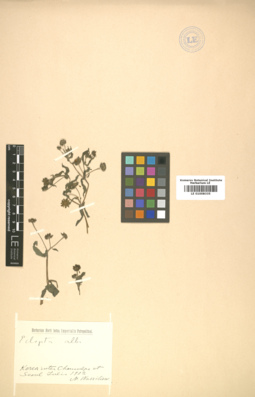
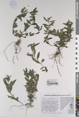
LE 01017217
Eclipta thermalis Bunge
Collectors: Bunge, Alexander Andrejewitsch von Field collecting number: [sine num.]. Collection date: 1831. Administrative regions: CN - China. Place of collection: China bor..Groups of specimens: Образцы сектора Центральной и Восточной АзииComment:[Imported description]
Taxon: Eclipta thermalis Bunge
Type specimen category: ?syntype
Original paper: 1833, Enum. pl. China bor. : 39
Collectors: [Bunge]
Record number: [sine num.]
Collection date: [1831]
Country: China
State/Province: Beijing
on the same sheet
LE 01017218
Eclipta thermalis Bunge
Collectors: Bunge, Alexander Andrejewitsch von Field collecting number: [sine num.]. Collection date: 08.1831. Administrative regions: CN - China. Place of collection: на дороге к р. Хуньхэ от фр[анцузского] кладбища, растет на берегу стоячих луж.Groups of specimens: Образцы сектора Центральной и Восточной АзииComment:[Imported description]
Taxon: Eclipta thermalis Bunge
Type specimen category: ?syntype
Original paper: 1833, Enum. pl. China bor. : 39
Collectors: [Bunge]
Record number: [sine num.]
Collection date: 08.1831
Country: China
State/Province: Beijing

LE 01017219
Eclipta thermalis Bunge
Field collecting number: [sine num.]. Collection date: 1831. Administrative regions: CN - China. Place of collection: Pekin.Groups of specimens: Образцы сектора Центральной и Восточной АзииComment:[Imported description]
Taxon: Eclipta thermalis Bunge
Type specimen category: ?syntype
Original paper: 1833, Enum. pl. China bor. : 39
Collectors: Kirilow
Record number: [sine num.]
Collection date: [1831]
Country: China
State/Province: Beijing
Herb. Fischer
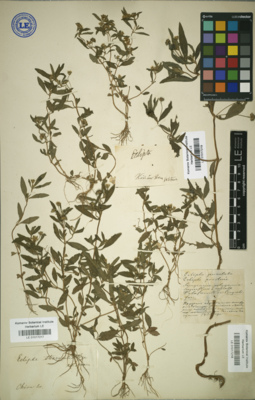
LE 01018485
Syntype of Eclipta thermalis Bunge
Collectors: Bunge, Alexander Andrejewitsch von Field collecting number: [sine num.]. Collection date: 1831. Administrative regions: CN - China. Place of collection: Chin. bor..Groups of specimens: Образцы сектора Центральной и Восточной Азии; Типовые образцы сектора Центральной и Восточной АзииComment:[Imported description]
Taxon: Eclipta thermalis Bunge
Type specimen category: syntype
Original paper: 1833, Enum. pl. China bor. : 39
Collectors: Bunge
Record number: [sine num.]
Collection date: [1831]
Country: China
State/Province: Beijing
LE 01194640
Eclipta prostrata (L.) L. det. Byalt, Vyacheslav Vyacheslavovich
Collectors: Byalt, Vyacheslav Vyacheslavovich; Korshunov, Mikhail Vladimirovich Field collecting number: 2104. Collection date: 14.04.2020. Administrative regions: AE - United Arab Emirates. Place of collection: Sharjah Emirate, Luluyah, end of Safi Esa Al Naqbi st. and gardens near Luluyah Beach [point 753]: near garden wall on wasteland with saline sand.Groups of specimens: Образцы общего сектора; Соглашение Минобрнауки №075-15-2021-1056; Бялт В.В.: Флора ФуджейрыOriginal label text: United Arab Emirates, Sharjah Emirate, Luluyah, end of Safi Esa Al Naqbi st. and gardens near Luluyah Beach. 25°23'24.43"N, 56°21'40.92"E, elevation 5 m. [point 753]: near garden wall on wasteland with saline sand, 14 IV 2020, fl., fr., V.V. Byalt, M.V. Korshunov 2104
LE 01259009
Eclipta procumbens Michx. det. Byalt, Vyacheslav Vyacheslavovich
Collectors: Byalt, Vyacheslav Vyacheslavovich; Korshunov, Mikhail Vladimirovich Field collecting number: 3033. Collection date: 19.05.2020. Administrative regions: AE - United Arab Emirates. Place of collection: Fujairah Emirate, Al Bidiya, Al Qalamoon Nursery, 0.3 km East from Eid Prayer Ground Bidyah [point 781a]: weed on irrigation in plantation.Groups of specimens: Образцы общего сектора; Соглашение Минобрнауки №075-15-2021-1056; Бялт В.В.: Флора ФуджейрыOriginal label text: United Arab Emirates, Fujairah Emirate, Al Bidiya, Al Qalamoon Nursery, 0.3 km East from Eid Prayer Ground Bidyah, 25°25'24.70"N, 56°20'18.77"E, elevation 22 m: [point 781a]: weed on irrigation in plantation, 19 V 2020, fl., fr., V.V. Byalt, M.V. Korshunov 3033
LE 01259011
Eclipta prostrata (L.) L. det. Byalt, Vyacheslav Vyacheslavovich
Collectors: Byalt, Vyacheslav Vyacheslavovich; Korshunov, Mikhail Vladimirovich Field collecting number: 2929. Collection date: 15.05.2020. Administrative regions: AE - United Arab Emirates. Place of collection: Fujairah Emirate, Al Bidiya, Al Qalamoon Nursery, 0.3 km East from Eid Prayer Ground Bidyah [point 781]: weed on irrigation under date palms.Groups of specimens: Образцы общего сектора; Соглашение Минобрнауки №075-15-2021-1056; Бялт В.В.: Флора ФуджейрыOriginal label text: United Arab Emirates, Fujairah Emirate, Al Bidiya, Al Qalamoon Nursery, 0.3 km East from Eid Prayer Ground Bidyah, 25°25'24.70"N, 56°20'18.77"E, elevation 22 m [point 781weed on irrigation under date palms, 15 V 2020, fl., fr., V.V. Byalt, M.V. Korshunov 2929
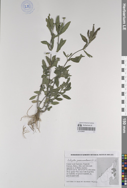
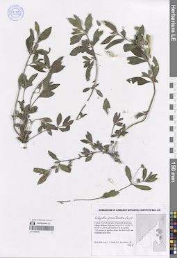
LE 01259036
Eclipta prostrata (L.) L. det. Byalt, Vyacheslav Vyacheslavovich
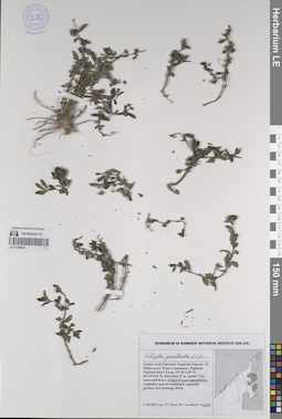
Collectors: Byalt, Vyacheslav Vyacheslavovich; Korshunov, Mikhail Vladimirovich Field collecting number: 690. Collection date: 17.03.2020. Administrative regions: AE - United Arab Emirates. Place of collection: Fujairah Emirate, Al Dibba town, Wam Community. Fujairah National Dairy Farm [point 714]: weed on irrigated grass plantation.Groups of specimens: Образцы общего сектора; Соглашение Минобрнауки №075-15-2021-1056; Бялт В.В.: Флора ФуджейрыOriginal label text: United Arab Emirates, Fujairah Emirate, Al Dibba town, Wam Community. Fujairah National Dairy Farm.
25°36'2.49"N, 56°14'2.64"E, elevation 25 m. [point 714]: weed on irrigated grass plantation, 17 III 2020, fl., fr., V.V. Byalt, M.V. Korshunov 690
LE 01259051
Eclipta prostrata (L.) L. det. Byalt, Vyacheslav Vyacheslavovich
Additional identifications: Eclipta procumbens Michx. det. Byalt, Vyacheslav Vyacheslavovich Collectors: Byalt, Vyacheslav Vyacheslavovich; Korshunov, Mikhail Vladimirovich Field collecting number: 2122. Collection date: 14.04.2020. Administrative regions: AE - United Arab Emirates. Place of collection: Fujairah Emirate, Bidya, villas and sideroads opposite to Al Bidiya market [point 752]: gravel-sand wadi.Groups of specimens: Образцы общего сектора; Соглашение Минобрнауки №075-15-2021-1056; Бялт В.В.: Флора ФуджейрыOriginal label text: United Arab Emirates, Fujairah Emirate, Bidya, villas and sideroads opposite to Al Bidiya market. 25°25'57.34"N, 56°21'6.57"E, elevation 10 m. [point 752]: in gravel-sand wadi, 14 IV 2020, fl., fr., V.V. Byalt, M.V. Korshunov 2122
LE 01259739
Eclipta prostrata (L.) L. det. Byalt, Vyacheslav Vyacheslavovich
Collectors: Byalt, Vyacheslav Vyacheslavovich; Korshunov, Mikhail Vladimirovich Field collecting number: 1395. Collection date: 30.03.2020. Administrative regions: AE - United Arab Emirates. Place of collection: Fujairah Emirate, village Bithna, Bithna Fort [point 725]: weed in garden close the fort wall.Groups of specimens: Образцы общего сектора; Соглашение Минобрнауки №075-15-2021-1056; Бялт В.В.: Флора ФуджейрыOriginal label text: UAE, Fujairah Emirate, village Bithna, Bithna Fort. 25°11'13.38"N, 56°14'17.34"E, elevation 172 m. [point 725]: weed in garden close the fort wall, 30 III 2020, fl., fr., V.V. Byalt, M.V. Korshunov 1395