View
Add
Copy
Edit
Delete
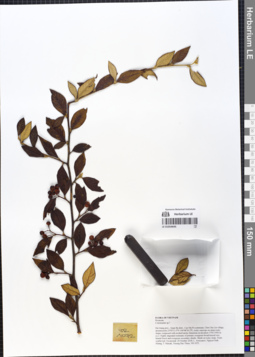
LE 01054645
Cotoneaster pannosus Franch. det. Averyanov, Leonid Vladimirovich at 01.12.2019
Additional identifications: Cotoneaster sp. ⟮prelim. ID⟯ det. Averyanov, Leonid Vladimirovich at 20.10.2018 Collectors: Averyanov, Leonid Vladimirovich; Khang Sinh Nguyen; Maisak, Tatiana Viktorovna; Truong Duc Thieu Field collecting number: VR1072. Collection date: 20.10.2018. Administrative regions: VN - Tinh Ha Giang. Groups of specimens: L. V. Averyanov specimens; L. V. Averyanov herbarium; L. V. Averyanov photosOriginal label text:FLORA OF VIETNAM
Coordinates (geographic position): 23° 5′ 13.5″ N, 104° 48′ 30.2″ E ±1000 mComment: Rosaceae
Cotoneaster sp.?
Ha Giang prov., Quan Ba distr., Cao Ma Po commune, Chin Chu Lin village, around point 23º05ʹ13.5ʺN 104º48ʹ30.2ʺE, rocky outcrops on steep rocky slopes composed with eroded karstic limestone at elevation 1750–1950 m a.s.l. Highly degraded remnants of primary evergreen broad-leaved very humid forest and evergreen secondary shrubs. Shrub on rocky slope. Fruits scarlet-red. Occasional. 20 October 2018, L. Averyanov, Nguyen Sinh Khang, T. Maisak, Truong Duc Thieu, VR 1072.
All photos © L. Averyanov & K.S. Nguyen
Record creation: 2019-05-23, Leonid Averyanov, PhotoScan D1Citation: Specimen LE 01054645 // Virtual herbarium of Komarov Botanical Institute RAS — http://re.herbariumle.ru/01054645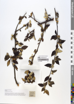
LE 01055886
Cotoneaster pannosus Franch. det. Khang Sinh Nguyen at 13.05.2017
Collectors: Khang Sinh Nguyen Field collecting number: NSK 880. Collection date: 13.05.2017. Administrative regions: VN - Tinh Ha Giang. Groups of specimens: L. V. Averyanov specimens; L. V. Averyanov herbariumOriginal label text:FLORA OF VIETNAM Rosaceae Cotoneaster pannosus Franch. Ha Giang province, Quan Ba district, Cao Ma Po commune, Vang Cha Phin village, around point 23°05?27.8??N, 104°48?28.1??E, at elevation of 1850 m a. s. l. Secondary evergreen broad-leaved forest on silicate mountain. Shrub about 1.5 m tall, flower purple. Not common. NSK 880, May 13, 2017. Nguyen Sinh Khang.
Coordinates (geographic position): 23° 5′ 27.8″ N, 104° 48′ 28.1″ E ±1000 mRecord creation: 2019-06-28, Leonid Averyanov, PhotoScan D1Citation: Specimen LE 01055886 // Virtual herbarium of Komarov Botanical Institute RAS — http://re.herbariumle.ru/01055886