View
Add
Copy
Edit
Delete
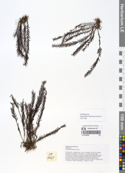
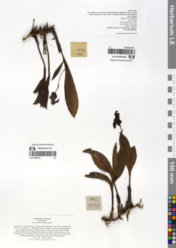
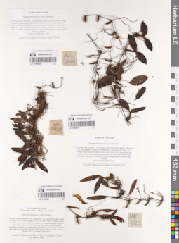
LE 01066820
Podochilus khasianus Hook.f. det. Averyanov, Leonid Vladimirovich at 11.10.2019
Collectors: Averyanov, Leonid Vladimirovich; Khang Sinh Nguyen; Maisak, Tatiana Viktorovna Field collecting number: VR1568. Collection date: 11.10.2019. Administrative regions: VN - Tinh Ha Giang. Groups of specimens: L. V. Averyanov specimens; L. V. Averyanov herbarium; Orchids of Vietnam, Laos and CambodiaOriginal label text:FLORA OF VIETNAM
Coordinates (geographic position): 23° 5′ 44.38″ N, 105° 1′ 17.11″ E ±1000 mRecord creation: 2020-01-05, Leonid Averyanov, PhotoScan D1. Processing status: work_status_1Citation: Specimen LE 01066820 // Virtual herbarium of Komarov Botanical Institute RAS — http://re.herbariumle.ru/01066820Orchidaceae
Podochilus khasianus Hook.f.,
Ha Giang Prov., Quan Ba Distr., Can Ty Commune, Sin Suoi Ho Village, around point 23.09566ºN 105.02142ºE. Very steep mountain slopes composed of solid highly eroded karstic limestone at elevation 800–1000 m a.s.l. Remnants of primary evergreen broad-leaved and coniferous (with Calocedrus rupestris and Xanthocyparis vietnamensis) humid forest. Lithophytic clustering herb on shady mossy rocks. Not rare. 11 October 2019, L. Averyanov, Nguyen Sinh Khang, T. Maisak, VR 1568.
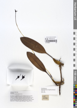
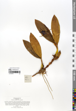
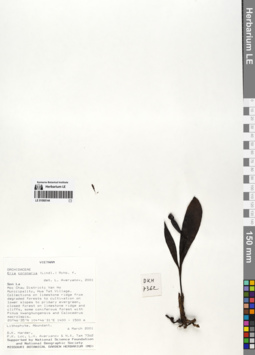
LE 01066821
Bulbophyllum longibrachiatum Z.H.Tsi det. Averyanov, Leonid Vladimirovich at 11.10.2019
Collectors: Averyanov, Leonid Vladimirovich; Khang Sinh Nguyen; Maisak, Tatiana Viktorovna Field collecting number: VR1570. Collection date: 11.10.2019. Administrative regions: VN - Tinh Ha Giang. Groups of specimens: L. V. Averyanov specimens; L. V. Averyanov herbarium; Orchids of Vietnam, Laos and CambodiaOriginal label text:FLORA OF VIETNAM
Orchidaceae
Bulbophyllum longibrachiatum Z.H. Tsi
Ha Giang Prov., Quan Ba Distr., Can Ty Commune, Sin Suoi Ho Village, around point 23.09566ºN 105.02142ºE. Very steep mountain slopes composed of solid highly eroded karstic limestone at elevation 800–1000 m a.s.l. Remnants of primary evergreen broad-leaved and coniferous (with Calocedrus rupestris and Xanthocyparis vietnamensis) humid forest. Creeping lithophytic and epiphytic herb. Leaves purple-violet below. Common. 11 October 2019, L. Averyanov, Nguyen Sinh Khang, T. Maisak, VR 1570.
All photos © L. Averyanov & K.S. Nguyen
Record creation: 2020-01-05, Leonid Averyanov, PhotoScan D1. Processing status: work_status_1Citation: Specimen LE 01066821 // Virtual herbarium of Komarov Botanical Institute RAS — http://re.herbariumle.ru/01066821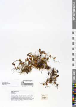
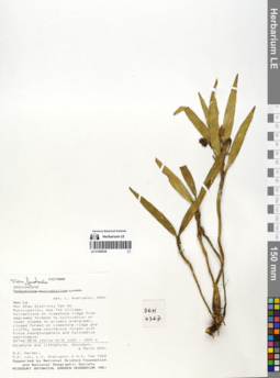
LE 01066822
Bulbophyllum sp. det. Averyanov, Leonid Vladimirovich at 11.10.2019
Collectors: Averyanov, Leonid Vladimirovich; Khang Sinh Nguyen; Maisak, Tatiana Viktorovna Field collecting number: VR1572. Collection date: 11.10.2019. Administrative regions: VN - Tinh Ha Giang. Groups of specimens: L. V. Averyanov specimens; L. V. Averyanov herbarium; Orchids of Vietnam, Laos and CambodiaOriginal label text:FLORA OF VIETNAM
Coordinates (geographic position): 23° 5′ 44.38″ N, 105° 1′ 17.11″ E ±1000 mComment: Orchidaceae
Bulbophyllum sp.
Ha Giang Prov., Quan Ba Distr., Can Ty Commune, Sin Suoi Ho Village, around point 23.09566ºN 105.02142ºE. Very steep mountain slopes composed of solid highly eroded karstic limestone at elevation 800–1000 m a.s.l. Remnants of primary evergreen broad-leaved and coniferous (with Calocedrus rupestris and Xanthocyparis vietnamensis) humid forest. Creeping epiphyte on old mossy tree. Occasional. 11 October 2019, L. Averyanov, Nguyen Sinh Khang, T. Maisak, VR 1572.
All photos © L. Averyanov & K.S. Nguyen
Record creation: 2020-01-05, Leonid Averyanov, PhotoScan D1. Processing status: work_status_1Citation: Specimen LE 01066822 // Virtual herbarium of Komarov Botanical Institute RAS — http://re.herbariumle.ru/01066822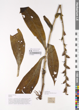
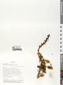
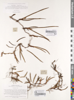
LE 01066823
Habenaria calcicola Aver. ⟮prelim. ID⟯ det. Averyanov, Leonid Vladimirovich at 11.10.2019
Collectors: Averyanov, Leonid Vladimirovich; Khang Sinh Nguyen; Maisak, Tatiana Viktorovna Field collecting number: VR1574. Collection date: 11.10.2019. Administrative regions: VN - Tinh Ha Giang. Groups of specimens: L. V. Averyanov specimens; L. V. Averyanov herbarium; Orchids of Vietnam, Laos and CambodiaOriginal label text:FLORA OF VIETNAM
Coordinates (geographic position): 23° 5′ 44.38″ N, 105° 1′ 17.11″ E ±1000 mRecord creation: 2020-01-05, Leonid Averyanov, PhotoScan D1. Processing status: work_status_1Citation: Specimen LE 01066823 // Virtual herbarium of Komarov Botanical Institute RAS — http://re.herbariumle.ru/01066823Orchidaceae
Habenaria calcicola Aver.?
Ha Giang Prov., Quan Ba Distr., Can Ty Commune, Sin Suoi Ho Village, around point 23.09566ºN 105.02142ºE. Very steep mountain slopes composed of solid highly eroded karstic limestone at elevation 800–1000 m a.s.l. Remnants of primary evergreen broad-leaved and coniferous (with Calocedrus rupestris and Xanthocyparis vietnamensis) humid forest. Terrestrial tuberiferous herb in shady place among rocks. Common.
11 October 2019, L. Averyanov, Nguyen Sinh Khang, T. Maisak, VR 1574.
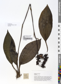
LE 01066824
Calanthe herbacea Lindl. det. Averyanov, Leonid Vladimirovich at 11.10.2019
Collectors: Averyanov, Leonid Vladimirovich; Khang Sinh Nguyen; Maisak, Tatiana Viktorovna Field collecting number: VR1581. Collection date: 11.10.2019. Administrative regions: VN - Tinh Ha Giang. Groups of specimens: L. V. Averyanov specimens; L. V. Averyanov herbarium; Orchids of Vietnam, Laos and CambodiaOriginal label text:FLORA OF VIETNAM
Orchidaceae
Calanthe herbacea Lindl.
Ha Giang Prov., Quan Ba Distr., Can Ty Commune, Sin Suoi Ho Village, around point 23.09566ºN 105.02142ºE. Very steep mountain slopes composed of solid highly eroded karstic limestone at elevation 800–1000 m a.s.l. Remnants of primary evergreen broad-leaved and coniferous (with Calocedrus rupestris and Xanthocyparis vietnamensis) humid forest. Terrestrial herb in shady rocky place. Not common. 11 October 2019, L. Averyanov, Nguyen Sinh Khang, T. Maisak, VR 1581.
All photos © L. Averyanov & K.S. Nguyen
Record creation: 2020-01-05, Leonid Averyanov, PhotoScan D1. Processing status: work_status_1Citation: Specimen LE 01066824 // Virtual herbarium of Komarov Botanical Institute RAS — http://re.herbariumle.ru/01066824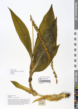
LE 01066825
Malaxis ophrydis (J.Koenig) Ormerod det. Averyanov, Leonid Vladimirovich at 11.10.2019
Collectors: Averyanov, Leonid Vladimirovich; Khang Sinh Nguyen; Maisak, Tatiana Viktorovna Field collecting number: VR1585. Collection date: 11.10.2019. Administrative regions: VN - Tinh Ha Giang. Groups of specimens: L. V. Averyanov specimens; L. V. Averyanov herbarium; Orchids of Vietnam, Laos and CambodiaOriginal label text:FLORA OF VIETNAM
Orchidaceae
Malaxis ophrydis (J. Koenig) Ormerod
Ha Giang Prov., Quan Ba Distr., Can Ty Commune, Sin Suoi Ho Village, around point 23.09566ºN 105.02142ºE. Very steep mountain slopes composed of solid highly eroded karstic limestone at elevation 800–1000 m a.s.l. Remnants of primary evergreen broad-leaved and coniferous (with Calocedrus rupestris and Xanthocyparis vietnamensis) humid forest. Terrestrial herb in shady place among rocks. Common.
11 October 2019, L. Averyanov, Nguyen Sinh Khang, T. Maisak, VR 1585.
All photos © L. Averyanov & K.S. Nguyen
Record creation: 2020-01-05, Leonid Averyanov, PhotoScan D1. Processing status: work_status_1Citation: Specimen LE 01066825 // Virtual herbarium of Komarov Botanical Institute RAS — http://re.herbariumle.ru/01066825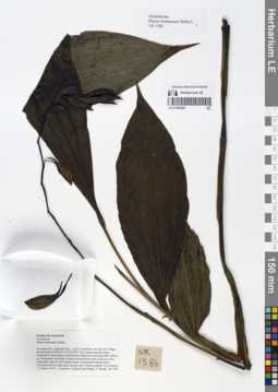
LE 01066826
Phaius mishmensis (Lindl. & Paxton) Rchb.f. det. Averyanov, Leonid Vladimirovich at 11.10.2019
Collectors: Averyanov, Leonid Vladimirovich; Khang Sinh Nguyen; Maisak, Tatiana Viktorovna Field collecting number: VR1586. Collection date: 11.10.2019. Administrative regions: VN - Tinh Ha Giang. Groups of specimens: L. V. Averyanov specimens; L. V. Averyanov herbarium; Orchids of Vietnam, Laos and CambodiaOriginal label text:FLORA OF VIETNAM
Coordinates (geographic position): 23° 5′ 44.38″ N, 105° 1′ 17.11″ E ±1000 mRecord creation: 2020-01-05, Leonid Averyanov, PhotoScan D1. Processing status: work_status_1Citation: Specimen LE 01066826 // Virtual herbarium of Komarov Botanical Institute RAS — http://re.herbariumle.ru/01066826Orchidaceae
Phaius mishmensis Rchb.f.,
Ha Giang Prov., Quan Ba Distr., Can Ty Commune, Sin Suoi Ho Village, around point 23.09566ºN 105.02142ºE. Very steep mountain slopes composed of solid highly eroded karstic limestone at elevation 800–1000 m a.s.l. Remnants of primary evergreen broad-leaved and coniferous (with Calocedrus rupestris and Xanthocyparis vietnamensis) humid forest. Terrestrial herb in shady place among rocks. Flowers pinkish. Not common. 11 October 2019, L. Averyanov, Nguyen Sinh Khang, T. Maisak, VR 1586.
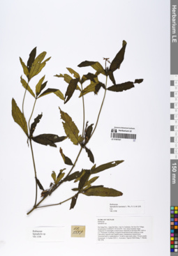
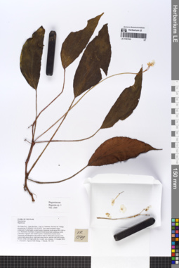
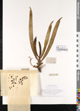
LE 01067021
Spiradiclis karstana L.Wu, X.Li & Q.R.Liu det. Averyanov, Leonid Vladimirovich at 11.10.2019
Collectors: Averyanov, Leonid Vladimirovich; Khang Sinh Nguyen; Maisak, Tatiana Viktorovna Field collecting number: VR1558. Collection date: 11.10.2019. Administrative regions: VN - Tinh Ha Giang. Groups of specimens: L. V. Averyanov specimens; L. V. Averyanov herbariumOriginal label text:FLORA OF VIETNAM
Rubiaceae
Spiradiclis karstana L. Wu, X. Li & Q.R. Liu
Ha Giang Prov., Quan Ba Distr., Can Ty Commune, Sin Suoi Ho Village, around point 23.09566ºN 105.02142ºE. Very steep mountain slopes composed of solid highly eroded karstic limestone at elevation 800–1000 m a.s.l. Remnants of primary evergreen broad-leaved and coniferous (with Calocedrus rupestris and Xanthocyparis vietnamensis) humid forest. Terrestrial herb or undershrub to 1 m tall in open rpcky place. Flowers purple. Occasional. 11 October 2019, L. Averyanov, Nguyen Sinh Khang, T. Maisak, VR 1558 (HN, LE01067021, LE01070220).
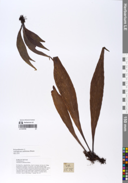
LE 01067022
Begonia longa C.-I Peng & W.C.Leong det. Averyanov, Leonid Vladimirovich at 06.04.2021
Additional identifications: Begonia sp. det. Averyanov, Leonid Vladimirovich at 11.10.2019; Holotype of Begonia semilunata Aver. det. Averyanov, Leonid Vladimirovich at 08.12.2020 Collectors: Averyanov, Leonid Vladimirovich; Khang Sinh Nguyen; Maisak, Tatiana Viktorovna Field collecting number: VR1549. Collection date: 11.10.2019. Administrative regions: VN - Tinh Ha Giang. Groups of specimens: L. V. Averyanov specimens; L. V. Averyanov herbariumOriginal label text:FLORA OF VIETNAM
Coordinates (geographic position): 23° 5′ 44.38″ N, 105° 1′ 17.11″ E ±1000 mComment: Begoniaceae
Begonia sp.
Ha Giang Prov., Quan Ba Distr., Can Ty Commune, Sin Suoi Ho Village, around point 23.09566ºN 105.02142ºE. Very steep mountain slopes composed of solid highly eroded karstic limestone at elevation 800–1000 m a.s.l. Remnants of primary evergreen broad-leaved and coniferous (with Calocedrus rupestris and Xanthocyparis vietnamensis) humid forest. Terrestrial and lithophytic rhizomatous herb in shady place among rocks. Leaves dark green above, light pale green below, petioles dull dirty purple. Flowers white with light pink tint. Locally very common. 11 October 2019, L. Averyanov, Nguyen Sinh Khang, T. Maisak, VR 1549.
Begonia longa C.-I Peng & W.C.Leong, 2014, in Ching-I Peng et al., Botanical Studies 55: 8 (Two new species of Begonia sect. Coelocentrum, B. guixiensis and B. longa, from Sino-Vietnamese limestone karsts)
TYPE: VIETNAM. Ha Giang Province, Quan Ba District, Can Ty Community, Sin Suoi Ho Village, elev. 650–1500 m; on face of limestone rock, in shaded and moist broadleaf forest on mountain slope. Locally frequent. Living collection made on 12 Nov 2004; type specimens (in flower) pressed from plants cultivated in the experimental greenhouse, Academia Sinica, 10 May 2007. Ching-I Peng, Wai-Chao Leong, Shin-Ming Ku, Tien Hiep Nguyen, Van The Pham & Xuan Tam Nguyen 20076-A (holotype: HAST; isotypes: A, E, FRIM, MO, P).
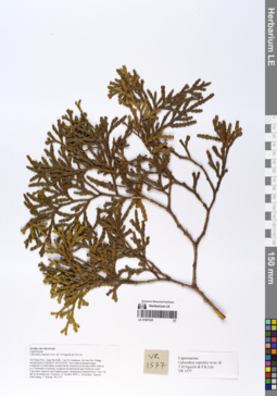
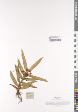
LE 01067023
Calocedrus rupestris Aver., T.H.Nguyên & P.K.Lôc det. Averyanov, Leonid Vladimirovich at 11.10.2019
Collectors: Averyanov, Leonid Vladimirovich; Khang Sinh Nguyen; Maisak, Tatiana Viktorovna Field collecting number: VR1577. Collection date: 11.10.2019. Administrative regions: VN - Tinh Ha Giang. Groups of specimens: L. V. Averyanov specimens; L. V. Averyanov herbariumOriginal label text:FLORA OF VIETNAM Cupressaceae Calocedrus rupestris Aver. & T.H.Nguyên & P.K.Lôc Ha Giang Prov., Quan Ba Distr., Can Ty Commune, Sin Suoi Ho Village, around point 23.09566ºN 105.02142ºE. Very steep mountain slopes composed of solid highly eroded karstic limestone at elevation 800–1000 m a.s.l. Remnants of primary evergreen broad-leaved and coniferous (with Calocedrus rupestris and Xanthocyparis vietnamensis) humid forest. Tree 7 m tall on mountain top. Common. 11 October 2019, L. Averyanov, Nguyen Sinh Khang, T. Maisak, VR 1577.
Coordinates (geographic position): 23° 5′ 44.38″ N, 105° 1′ 17.11″ E ±1000 mRecord creation: 2019-12-31, Leonid Averyanov, PhotoScan D1Citation: Specimen LE 01067023 // Virtual herbarium of Komarov Botanical Institute RAS — http://re.herbariumle.ru/01067023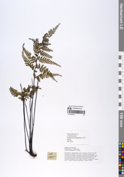
LE 01067024
Asplenium dianguiense X.C.Zhang det. Averyanov, Leonid Vladimirovich at 10.12.2019
Collectors: Averyanov, Leonid Vladimirovich; Khang Sinh Nguyen; Maisak, Tatiana Viktorovna Field collecting number: VR1555. Collection date: 11.10.2019. Administrative regions: VN - Tinh Ha Giang. Groups of specimens: L. V. Averyanov specimens; L. V. Averyanov herbariumOriginal label text:FLORA OF VIETNAM Polypodiaceae s.l. (Aspleniaceae) Asplenium dianguiense X.C. Zhang Ha Giang Prov., Quan Ba Distr., Can Ty Commune, Sin Suoi Ho Village, around point 23.09566ºN 105.02142ºE. Very steep mountain slopes composed of solid highly eroded karstic limestone at elevation 800–1000 m a.s.l. Remnants of primary evergreen broad-leaved and coniferous (with Calocedrus rupestris and Xanthocyparis vietnamensis) humid forest. Terrestrial and lithophytic fern on steep rocky slope. Occasional. 11 October 2019, L. Averyanov, Nguyen Sinh Khang, T. Maisak, VR 1555.
Coordinates (geographic position): 23° 5′ 44.38″ N, 105° 1′ 17.11″ E ±1000 mRecord creation: 2019-12-31, Leonid Averyanov, PhotoScan D1Citation: Specimen LE 01067024 // Virtual herbarium of Komarov Botanical Institute RAS — http://re.herbariumle.ru/01067024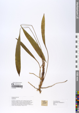
LE 01067025
Ophiopogon tonkinensis L.Rodr. det. Averyanov, Leonid Vladimirovich at 10.12.2019
Collectors: Averyanov, Leonid Vladimirovich; Khang Sinh Nguyen; Maisak, Tatiana Viktorovna Field collecting number: VR1551. Collection date: 11.10.2019. Administrative regions: VN - Tinh Ha Giang. Groups of specimens: L. V. Averyanov specimens; L. V. Averyanov herbariumOriginal label text:FLORA OF VIETNAM Convallariaceae Ophiopogon tonkinensis L. Rodr. Ha Giang Prov., Quan Ba Distr., Can Ty Commune, Sin Suoi Ho Village, around point 23.09566ºN 105.02142ºE. Very steep mountain slopes composed of solid highly eroded karstic limestone at elevation 800–1000 m a.s.l. Remnants of primary evergreen broad-leaved and coniferous (with Calocedrus rupestris and Xanthocyparis vietnamensis) humid forest. Terrestrial herb in shady place among rocks. Occasional. 11 October 2019, L. Averyanov, Nguyen Sinh Khang, T. Maisak, VR 1551.
Coordinates (geographic position): 23° 5′ 44.38″ N, 105° 1′ 17.11″ E ±1000 mRecord creation: 2019-12-31, Leonid Averyanov, PhotoScan D1Citation: Specimen LE 01067025 // Virtual herbarium of Komarov Botanical Institute RAS — http://re.herbariumle.ru/01067025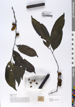
LE 01067026
Diospyros curranii Merr. det. Averyanov, Leonid Vladimirovich at 10.12.2019
Collectors: Averyanov, Leonid Vladimirovich; Khang Sinh Nguyen; Maisak, Tatiana Viktorovna Field collecting number: VR1550. Collection date: 11.10.2019. Administrative regions: VN - Tinh Ha Giang. Groups of specimens: L. V. Averyanov specimens; L. V. Averyanov herbariumOriginal label text:FLORA OF VIETNAM Ebenaceae Diospyros curranii Merr. Ha Giang Prov., Quan Ba Distr., Can Ty Commune, Sin Suoi Ho Village, around point 23.09566ºN 105.02142ºE. Very steep mountain slopes composed of solid highly eroded karstic limestone at elevation 800–1000 m a.s.l. Remnants of primary evergreen broad-leaved and coniferous (with Calocedrus rupestris and Xanthocyparis vietnamensis) humid forest. Tree 10-15 m tall. Fruits light dull brownish. Common. Timber of a good quality. 11 October 2019, L. Averyanov, Nguyen Sinh Khang, T. Maisak, VR 1550.
Coordinates (geographic position): 23° 5′ 44.38″ N, 105° 1′ 17.11″ E ±1000 mRecord creation: 2019-12-31, Leonid Averyanov, PhotoScan D1Citation: Specimen LE 01067026 // Virtual herbarium of Komarov Botanical Institute RAS — http://re.herbariumle.ru/01067026
LE 01067027
Aspidistra nigra Aver., Tillich & S.K.Nguyen ⟮prelim. ID⟯ det. Khang Sinh Nguyen at 09.04.2022
Additional identifications: Aspidistra sp. det. Averyanov, Leonid Vladimirovich at 11.10.2019; Aspidistra cornuta Aver. ⟨not published name⟩ det. Averyanov, Leonid Vladimirovich at 23.03.2022 Collectors: Averyanov, Leonid Vladimirovich; Khang Sinh Nguyen; Maisak, Tatiana Viktorovna Field collecting number: VR1552. Collection date: 11.10.2019. Administrative regions: VN - Tinh Ha Giang. Groups of specimens: L. V. Averyanov specimens; L. V. Averyanov herbariumOriginal label text:FLORA OF VIETNAM
Coordinates (geographic position): 23° 5′ 44.38″ N, 105° 1′ 17.11″ E ±1000 mRecord creation: 2019-12-31, Leonid Averyanov, PhotoScan D1Citation: Specimen LE 01067027 // Virtual herbarium of Komarov Botanical Institute RAS — http://re.herbariumle.ru/01067027Convallariaceae
Aspidistra sp.
Ha Giang Prov., Quan Ba Distr., Can Ty Commune, Sin Suoi Ho Village, around point 23.09566ºN 105.02142ºE. Very steep mountain slopes composed of solid highly eroded karstic limestone at elevation 800–1000 m a.s.l. Remnants of primary evergreen broad-leaved and coniferous (with Calocedrus rupestris and Xanthocyparis vietnamensis) humid forest. Terrestrial rhizomatous herb in shady place among rocks. Leaves dark green with many unclear yellowish spots (sometime uniform green). Old flowers looks black. Occasional. 11 October 2019, L. Averyanov, Nguyen Sinh Khang, T. Maisak, VR 1552.
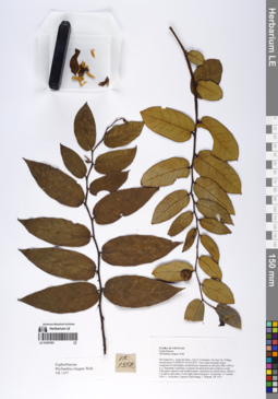
LE 01067061
Phyllanthus elegans Wall. det. Averyanov, Leonid Vladimirovich at 10.12.2019
Collectors: Averyanov, Leonid Vladimirovich; Khang Sinh Nguyen; Maisak, Tatiana Viktorovna Field collecting number: VR1557. Collection date: 11.10.2019. Administrative regions: VN - Tinh Ha Giang. Groups of specimens: L. V. Averyanov specimens; L. V. Averyanov herbariumOriginal label text:FLORA OF VIETNAM Euphorbiaceae Phyllanthus elegans Wall. Ha Giang Prov., Quan Ba Distr., Can Ty Commune, Sin Suoi Ho Village, around point 23.09566ºN 105.02142ºE. Very steep mountain slopes composed of solid highly eroded karstic limestone at elevation 800–1000 m a.s.l. Remnants of primary evergreen broad-leaved and coniferous (with Calocedrus rupestris and Xanthocyparis vietnamensis) humid forest. Shrub 2-3 m tall in open place. Fruits light yellowish-green. Occasional. 11 October 2019, L. Averyanov, Nguyen Sinh Khang, T. Maisak, VR 1557.
Coordinates (geographic position): 23° 5′ 44.38″ N, 105° 1′ 17.11″ E ±1000 mRecord creation: 2019-12-31, Leonid Averyanov, PhotoScan D1Citation: Specimen LE 01067061 // Virtual herbarium of Komarov Botanical Institute RAS — http://re.herbariumle.ru/01067061
LE 01067062
Quercus glauca Thunb. det. Averyanov, Leonid Vladimirovich at 10.12.2019
Collectors: Averyanov, Leonid Vladimirovich; Khang Sinh Nguyen; Maisak, Tatiana Viktorovna Field collecting number: VR1559. Collection date: 11.10.2019. Administrative regions: VN - Tinh Ha Giang. Groups of specimens: L. V. Averyanov specimens; L. V. Averyanov herbariumOriginal label text:FLORA OF VIETNAM Fagaceae Quercus glauca Thunb. Ha Giang Prov., Quan Ba Distr., Can Ty Commune, Sin Suoi Ho Village, around point 23.09566ºN 105.02142ºE. Very steep mountain slopes composed of solid highly eroded karstic limestone at elevation 800–1000 m a.s.l. Remnants of primary evergreen broad-leaved and coniferous (with Calocedrus rupestris and Xanthocyparis vietnamensis) humid forest. Tree 7-10 m tall on mountain top. Seeds glossy green. Not common. 11 October 2019, L. Averyanov, Nguyen Sinh Khang, T. Maisak, VR 1559.
Coordinates (geographic position): 23° 5′ 44.38″ N, 105° 1′ 17.11″ E ±1000 mRecord creation: 2019-12-31, Leonid Averyanov, PhotoScan D1Citation: Specimen LE 01067062 // Virtual herbarium of Komarov Botanical Institute RAS — http://re.herbariumle.ru/01067062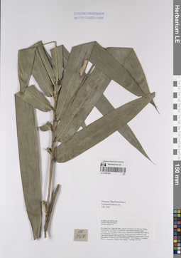
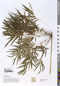
LE 01067063
Vietnamcalamus sp. det. Averyanov, Leonid Vladimirovich, Khang Sinh Nguyen at 11.10.2019
Collectors: Averyanov, Leonid Vladimirovich; Khang Sinh Nguyen; Maisak, Tatiana Viktorovna Field collecting number: VR1567. Collection date: 11.10.2019. Administrative regions: VN - Tinh Ha Giang. Groups of specimens: L. V. Averyanov specimens; L. V. Averyanov herbariumOriginal label text:FLORA OF VIETNAM Poaceae (Bambusoideae) Vietnamcalamus sp. Ha Giang Prov., Quan Ba Distr., Can Ty Commune, Sin Suoi Ho Village, around point 23.09566ºN 105.02142ºE. Very steep mountain slopes composed of solid highly eroded karstic limestone at elevation 800–1000 m a.s.l. Remnants of primary evergreen broad-leaved and coniferous (with Calocedrus rupestris and Xanthocyparis vietnamensis) humid forest. Woody grass about 3 m tall on rocky top of mountain. Very common. 11 October 2019, L. Averyanov, Nguyen Sinh Khang, T. Maisak, VR 1567.
Coordinates (geographic position): 23° 5′ 44.38″ N, 105° 1′ 17.11″ E ±1000 mRecord creation: 2019-12-31, Leonid Averyanov, PhotoScan D1Citation: Specimen LE 01067063 // Virtual herbarium of Komarov Botanical Institute RAS — http://re.herbariumle.ru/01067063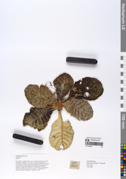
LE 01067064
Paraboea nutans D.Fang & D.H.Qin det. Averyanov, Leonid Vladimirovich at 10.12.2019
Collectors: Averyanov, Leonid Vladimirovich; Khang Sinh Nguyen; Maisak, Tatiana Viktorovna Field collecting number: VR1569. Collection date: 11.10.2019. Administrative regions: VN - Tinh Ha Giang. Groups of specimens: L. V. Averyanov specimens; L. V. Averyanov herbariumOriginal label text:FLORA OF VIETNAM Gesneriaceae Paraboea nutans D. Fang & D.H. Qin Ha Giang Prov., Quan Ba Distr., Can Ty Commune, Sin Suoi Ho Village, around point 23.09566ºN 105.02142ºE. Very steep mountain slopes composed of solid highly eroded karstic limestone at elevation 800–1000 m a.s.l. Remnants of primary evergreen broad-leaved and coniferous (with Calocedrus rupestris and Xanthocyparis vietnamensis) humid forest. Lithophytic rosulate herb on shady mossy vertical cliff. Leaves dark green above, almost gray-white below. Not common. 11 October 2019, L. Averyanov, Nguyen Sinh Khang, T. Maisak, VR 1569.
Coordinates (geographic position): 23° 5′ 44.38″ N, 105° 1′ 17.11″ E ±1000 mRecord creation: 2019-12-31, Leonid Averyanov, PhotoScan D1Citation: Specimen LE 01067064 // Virtual herbarium of Komarov Botanical Institute RAS — http://re.herbariumle.ru/01067064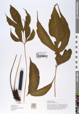
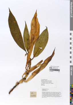
LE 01067065
Tectaria polymorpha (Hook.) Copel. det. Averyanov, Leonid Vladimirovich at 10.12.2019
Collectors: Averyanov, Leonid Vladimirovich; Khang Sinh Nguyen; Maisak, Tatiana Viktorovna Field collecting number: VR1573. Collection date: 11.10.2019. Administrative regions: VN - Tinh Ha Giang. Groups of specimens: L. V. Averyanov specimens; L. V. Averyanov herbariumOriginal label text:FLORA OF VIETNAM Polypodiaceae s.l. (Tectariaceae) Tectaria polymorpha (Wall. ex Hook.) Copel. Ha Giang Prov., Quan Ba Distr., Can Ty Commune, Sin Suoi Ho Village, around point 23.09566ºN 105.02142ºE. Very steep mountain slopes composed of solid highly eroded karstic limestone at elevation 800–1000 m a.s.l. Remnants of primary evergreen broad-leaved and coniferous (with Calocedrus rupestris and Xanthocyparis vietnamensis) humid forest. Terrestrial fern in shady rocky place. Common. 11 October 2019, L. Averyanov, Nguyen Sinh Khang, T. Maisak, VR 1573.
Coordinates (geographic position): 23° 5′ 44.38″ N, 105° 1′ 17.11″ E ±1000 mRecord creation: 2019-12-31, Leonid Averyanov, PhotoScan D1Citation: Specimen LE 01067065 // Virtual herbarium of Komarov Botanical Institute RAS — http://re.herbariumle.ru/01067065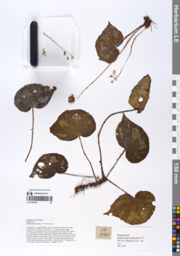
LE 01067066
Paratype of Begonia pseudodryadis C.Y.Wu var. bitepala Aver. det. Averyanov, Leonid Vladimirovich at 19.12.2019
Collectors: Averyanov, Leonid Vladimirovich; Khang Sinh Nguyen; Maisak, Tatiana Viktorovna Field collecting number: VR1571. Collection date: 11.10.2019. Administrative regions: VN - Tinh Ha Giang. Groups of specimens: L. V. Averyanov specimens; L. V. Averyanov herbariumOriginal label text:FLORA OF VIETNAM Begoniaceae Begonia pseudodryadis C.Y. Wu var. bitepala Aver., var. nov. Ha Giang Prov., Quan Ba Distr., Can Ty Commune, Sin Suoi Ho Village, around point 23.09566ºN 105.02142ºE. Very steep mountain slopes composed of solid highly eroded karstic limestone at elevation 800–1000 m a.s.l. Remnants of primary evergreen broad-leaved and coniferous (with Calocedrus rupestris and Xanthocyparis vietnamensis) humid forest. Rosulate lithophytic herb on vertical shady mossy cliff. Leaves dark olive-green with irregular whitish spots above, pale purple with light greenish spots below. Flowers light pink-purple, anther yellow. Locally common. 11 October 2019, L. Averyanov, Nguyen Sinh Khang, T. Maisak, VR 1571.
Coordinates (geographic position): 23° 5′ 44.38″ N, 105° 1′ 17.11″ E ±1000 mRecord creation: 2019-12-31, Leonid Averyanov, PhotoScan D1Citation: Specimen LE 01067066 // Virtual herbarium of Komarov Botanical Institute RAS — http://re.herbariumle.ru/01067066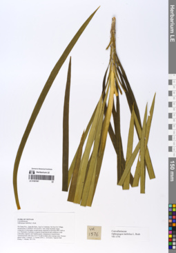
LE 01067067
Ophiopogon latifolius L.Rodr. det. Averyanov, Leonid Vladimirovich, Noriyuki Tanaka at 11.10.2019
Collectors: Averyanov, Leonid Vladimirovich; Khang Sinh Nguyen; Maisak, Tatiana Viktorovna Field collecting number: VR1576. Collection date: 11.10.2019. Administrative regions: VN - Tinh Ha Giang. Groups of specimens: L. V. Averyanov specimens; L. V. Averyanov herbariumOriginal label text:FLORA OF VIETNAM
Coordinates (geographic position): 23° 5′ 44.38″ N, 105° 1′ 17.11″ E ±1000 mRecord creation: 2019-12-31, Leonid Averyanov, PhotoScan D1Citation: Specimen LE 01067067 // Virtual herbarium of Komarov Botanical Institute RAS — http://re.herbariumle.ru/01067067Convallariaceae
Ophiopogon latifolius L. Rodr.
Ha Giang Prov., Quan Ba Distr., Can Ty Commune, Sin Suoi Ho Village, around point 23.09566ºN 105.02142ºE. Very steep mountain slopes composed of solid highly eroded karstic limestone at elevation 800–1000 m a.s.l. Remnants of primary evergreen broad-leaved and coniferous (with Calocedrus rupestris and Xanthocyparis vietnamensis) humid forest. Terrestrial herb with stem 0.6-0.7 m tall in shady place among rocks. Flowers almost white. Common. 11 October 2019, L. Averyanov, Nguyen Sinh Khang, T. Maisak, VR 1576.
LE 01067068
Antrophyum callifolium Blume det. Averyanov, Leonid Vladimirovich at 10.12.2019
Collectors: Averyanov, Leonid Vladimirovich; Khang Sinh Nguyen; Maisak, Tatiana Viktorovna Field collecting number: VR1575. Collection date: 11.10.2019. Administrative regions: VN - Tinh Ha Giang. Groups of specimens: L. V. Averyanov specimens; L. V. Averyanov herbariumOriginal label text:FLORA OF VIETNAM Polypodiaceae s.l. Antrophyum callifolium Blume Ha Giang Prov., Quan Ba Distr., Can Ty Commune, Sin Suoi Ho Village, around point 23.09566ºN 105.02142ºE. Very steep mountain slopes composed of solid highly eroded karstic limestone at elevation 800–1000 m a.s.l. Remnants of primary evergreen broad-leaved and coniferous (with Calocedrus rupestris and Xanthocyparis vietnamensis) humid forest. Lithophytic fern on shady mossy cliff. Common. 11 October 2019, L. Averyanov, Nguyen Sinh Khang, T. Maisak, VR 1575.
Coordinates (geographic position): 23° 5′ 44.38″ N, 105° 1′ 17.11″ E ±1000 mRecord creation: 2019-12-31, Leonid Averyanov, PhotoScan D1Citation: Specimen LE 01067068 // Virtual herbarium of Komarov Botanical Institute RAS — http://re.herbariumle.ru/01067068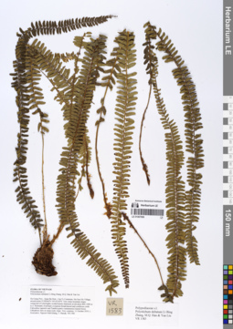
LE 01067069
Polystichum deltatum Li Bing Zhang, M.Q.Han & Yan Liu det. Averyanov, Leonid Vladimirovich at 10.12.2019
Collectors: Averyanov, Leonid Vladimirovich; Khang Sinh Nguyen; Maisak, Tatiana Viktorovna Field collecting number: VR1583. Collection date: 11.10.2019. Administrative regions: VN - Tinh Ha Giang. Groups of specimens: L. V. Averyanov specimens; L. V. Averyanov herbariumOriginal label text:FLORA OF VIETNAM
Coordinates (geographic position): 23° 5′ 44.38″ N, 105° 1′ 17.11″ E ±1000 mRecord creation: 2019-12-31, Leonid Averyanov, PhotoScan D1Citation: Specimen LE 01067069 // Virtual herbarium of Komarov Botanical Institute RAS — http://re.herbariumle.ru/01067069Polypodiaceae s.l.
Polystichum deltatum Li Bing Zhang, M.Q. Han & Yan Liu
Ha Giang Prov., Quan Ba Distr., Can Ty Commune, Sin Suoi Ho Village, around point 23.09566ºN 105.02142ºE. Very steep mountain slopes composed of solid highly eroded karstic limestone at elevation 800–1000 m a.s.l. Remnants of primary evergreen broad-leaved and coniferous (with Calocedrus rupestris and Xanthocyparis vietnamensis) humid forest. Lithophytic fern on steep rocky slope. Very common. 11 October 2019, L. Averyanov, Nguyen Sinh Khang, T. Maisak, VR 1583.
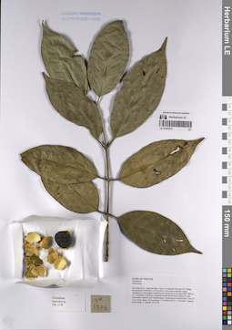
LE 01067070
Garcinia sp. det. Averyanov, Leonid Vladimirovich at 10.12.2019
Collectors: Averyanov, Leonid Vladimirovich; Khang Sinh Nguyen; Maisak, Tatiana Viktorovna Field collecting number: VR1578. Collection date: 11.10.2019. Administrative regions: VN - Tinh Ha Giang. Groups of specimens: L. V. Averyanov specimens; L. V. Averyanov herbariumOriginal label text:FLORA OF VIETNAM
Coordinates (geographic position): 23° 5′ 44.38″ N, 105° 1′ 17.11″ E ±1000 mRecord creation: 2019-12-31, Leonid Averyanov, PhotoScan D1Citation: Specimen LE 01067070 // Virtual herbarium of Komarov Botanical Institute RAS — http://re.herbariumle.ru/01067070Clusiaceae
Garcinia sp.
Ha Giang Prov., Quan Ba Distr., Can Ty Commune, Sin Suoi Ho Village, around point 23.09566ºN 105.02142ºE. Very steep mountain slopes composed of solid highly eroded karstic limestone at elevation 800–1000 m a.s.l. Remnants of primary evergreen broad-leaved and coniferous (with Calocedrus rupestris and Xanthocyparis vietnamensis) humid forest. Tree 10-15 m. Fruits green. Very common. 11 October 2019, L. Averyanov, Nguyen Sinh Khang, T. Maisak, VR 1578.
LE 01067071
Rohdea wattii (C.B.Clarke) Yamashita & M.N.Tamura det. Averyanov, Leonid Vladimirovich at 10.12.2019
Additional identifications: Tupistra wattii Hook.f. det. Averyanov, Leonid Vladimirovich at 10.12.2019 Collectors: Averyanov, Leonid Vladimirovich; Khang Sinh Nguyen; Maisak, Tatiana Viktorovna Field collecting number: VR1579. Collection date: 11.10.2019. Administrative regions: VN - Tinh Ha Giang. Groups of specimens: L. V. Averyanov specimens; L. V. Averyanov herbariumOriginal label text:FLORA OF VIETNAM Convallariaceae Rohdea wattii (C.B.Clarke) Yamashita & M.N.Tamura (= Tupistra wattii (C.B. Clarke) Hook.f.) Ha Giang Prov., Quan Ba Distr., Can Ty Commune, Sin Suoi Ho Village, around point 23.09566ºN 105.02142ºE. Very steep mountain slopes composed of solid highly eroded karstic limestone at elevation 800–1000 m a.s.l. Remnants of primary evergreen broad-leaved and coniferous (with Calocedrus rupestris and Xanthocyparis vietnamensis) humid forest. Terrestrial herb in shady place among rocks. Flowers and flower bracts green. Very common. 11 October 2019, L. Averyanov, Nguyen Sinh Khang, T. Maisak, VR 1579.
Coordinates (geographic position): 23° 5′ 44.38″ N, 105° 1′ 17.11″ E ±1000 mRecord creation: 2019-12-31, Leonid Averyanov, PhotoScan D1Citation: Specimen LE 01067071 // Virtual herbarium of Komarov Botanical Institute RAS — http://re.herbariumle.ru/01067071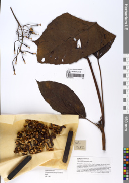
LE 01067072
Trigonostemon thyrsoideus Stapf det. Averyanov, Leonid Vladimirovich at 10.12.2019
Collectors: Averyanov, Leonid Vladimirovich; Khang Sinh Nguyen; Maisak, Tatiana Viktorovna Field collecting number: VR1582. Collection date: 11.10.2019. Administrative regions: VN - Tinh Ha Giang. Groups of specimens: L. V. Averyanov specimens; L. V. Averyanov herbariumOriginal label text:FLORA OF VIETNAM Euphorbiaceae Trigonostemon thyrsoideus Stapf Ha Giang Prov., Quan Ba Distr., Can Ty Commune, Sin Suoi Ho Village, around point 23.09566ºN 105.02142ºE. Very steep mountain slopes composed of solid highly eroded karstic limestone at elevation 800–1000 m a.s.l. Remnants of primary evergreen broad-leaved and coniferous (with Calocedrus rupestris and Xanthocyparis vietnamensis) humid forest. Treelet of shrub 3-5 m tall and 3-4 cm in diameter. Fruits light green. Common. 11 October 2019, L. Averyanov, Nguyen Sinh Khang, T. Maisak, VR 1582.
Coordinates (geographic position): 23° 5′ 44.38″ N, 105° 1′ 17.11″ E ±1000 mRecord creation: 2019-12-31, Leonid Averyanov, PhotoScan D1Citation: Specimen LE 01067072 // Virtual herbarium of Komarov Botanical Institute RAS — http://re.herbariumle.ru/01067072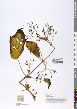
LE 01067073
Ornithoboea wildeana Craib det. Averyanov, Leonid Vladimirovich at 10.12.2019
Collectors: Averyanov, Leonid Vladimirovich; Khang Sinh Nguyen; Maisak, Tatiana Viktorovna Field collecting number: VR1584. Collection date: 11.10.2019. Administrative regions: VN - Tinh Ha Giang. Groups of specimens: L. V. Averyanov specimens; L. V. Averyanov herbariumOriginal label text:FLORA OF VIETNAM Gesneriaceae Ornithoboea wildeana Craib Ha Giang Prov., Quan Ba Distr., Can Ty Commune, Sin Suoi Ho Village, around point 23.09566ºN 105.02142ºE. Very steep mountain slopes composed of solid highly eroded karstic limestone at elevation 800–1000 m a.s.l. Remnants of primary evergreen broad-leaved and coniferous (with Calocedrus rupestris and Xanthocyparis vietnamensis) humid forest. Lithophytic herb to 1 m tall on steep rocky slope. Very common. 11 October 2019, L. Averyanov, Nguyen Sinh Khang, T. Maisak, VR 1584.
Coordinates (geographic position): 23° 5′ 44.38″ N, 105° 1′ 17.11″ E ±1000 mRecord creation: 2019-12-31, Leonid Averyanov, PhotoScan D1Citation: Specimen LE 01067073 // Virtual herbarium of Komarov Botanical Institute RAS — http://re.herbariumle.ru/01067073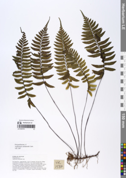
LE 01067074
Hymenasplenium unilaterale (Lam.) Hayata det. Averyanov, Leonid Vladimirovich at 19.02.2020
Additional identifications: Asplenium unilaterale Lam. det. Averyanov, Leonid Vladimirovich at 10.12.2019 Collectors: Averyanov, Leonid Vladimirovich; Khang Sinh Nguyen; Maisak, Tatiana Viktorovna Field collecting number: VR1587. Collection date: 11.10.2019. Administrative regions: VN - Tinh Ha Giang. Groups of specimens: L. V. Averyanov specimens; L. V. Averyanov herbariumOriginal label text:FLORA OF VIETNAM Polypodiaceae s.l. Asplenium unilaterale Lam. Ha Giang Prov., Quan Ba Distr., Can Ty Commune, Sin Suoi Ho Village, around point 23.09566ºN 105.02142ºE. Very steep mountain slopes composed of solid highly eroded karstic limestone at elevation 800–1000 m a.s.l. Remnants of primary evergreen broad-leaved and coniferous (with Calocedrus rupestris and Xanthocyparis vietnamensis) humid forest. Terrestrial and occasionally lithophytic fern on shady very steep rocky slope. Common. 11 October 2019, L. Averyanov, Nguyen Sinh Khang, T. Maisak, VR 1587.
Coordinates (geographic position): 23° 5′ 44.38″ N, 105° 1′ 17.11″ E ±1000 mRecord creation: 2019-12-31, Leonid Averyanov, PhotoScan D1Citation: Specimen LE 01067074 // Virtual herbarium of Komarov Botanical Institute RAS — http://re.herbariumle.ru/01067074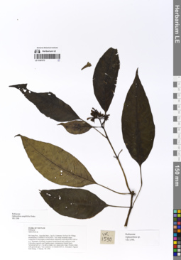
LE 01067075
Ophiorrhiza amplifolia Drake det. Averyanov, Leonid Vladimirovich at 11.10.2019
Collectors: Averyanov, Leonid Vladimirovich; Khang Sinh Nguyen; Maisak, Tatiana Viktorovna Field collecting number: VR1590. Collection date: 11.10.2019. Administrative regions: VN - Tinh Ha Giang. Groups of specimens: L. V. Averyanov specimens; L. V. Averyanov herbariumOriginal label text:FLORA OF VIETNAM
Rubiaceae
Ophiorrhiza amplifolia Drake
Ha Giang Prov., Quan Ba Distr., Can Ty Commune, Sin Suoi Ho Village, around point 23.09566ºN 105.02142ºE. Very steep mountain slopes composed of solid highly eroded karstic limestone at elevation 800–1000 m a.s.l. Remnants of primary evergreen broad-leaved and coniferous (with Calocedrus rupestris and Xanthocyparis vietnamensis) humid forest. Terrestrial herb to 1.5 m tall on shady very steep rocky slope. Flowers white with greenish apex. Very common. 11 October 2019, L. Averyanov, Nguyen Sinh Khang, T. Maisak, VR 1590 (HN, LE01067075, LE01070186).
LE 01067076
Neomicrocalamus prainii (Gamble) Keng f. det. Averyanov, Leonid Vladimirovich, Khang Sinh Nguyen at 11.10.2019
Collectors: Averyanov, Leonid Vladimirovich; Khang Sinh Nguyen; Maisak, Tatiana Viktorovna Field collecting number: VR1580. Collection date: 11.10.2019. Administrative regions: VN - Tinh Ha Giang. Groups of specimens: L. V. Averyanov specimens; L. V. Averyanov herbariumOriginal label text:FLORA OF VIETNAM Poaceae (Bambusoideae) Neomicrocalamus prainii (Gamble) Keng f.* Ha Giang Prov., Quan Ba Distr., Can Ty Commune, Sin Suoi Ho Village, around point 23.09566ºN 105.02142ºE. Very steep mountain slopes composed of solid highly eroded karstic limestone at elevation 800–1000 m a.s.l. Remnants of primary evergreen broad-leaved and coniferous (with Calocedrus rupestris and Xanthocyparis vietnamensis) humid forest. Woody grass with pendulous stems to 10 m long on very steep rocky slopes and cliffs. Locally very common. 11 October 2019, L. Averyanov, Nguyen Sinh Khang, T. Maisak, VR 1580.
Coordinates (geographic position): 23° 5′ 44.38″ N, 105° 1′ 17.11″ E ±1000 mRecord creation: 2019-12-31, Leonid Averyanov, PhotoScan D1Citation: Specimen LE 01067076 // Virtual herbarium of Komarov Botanical Institute RAS — http://re.herbariumle.ru/01067076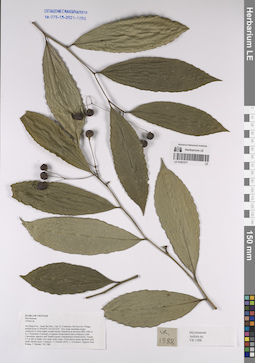
LE 01067077
Ardisia sp. det. Averyanov, Leonid Vladimirovich at 10.12.2019
Collectors: Averyanov, Leonid Vladimirovich; Khang Sinh Nguyen; Maisak, Tatiana Viktorovna Field collecting number: VR1588. Collection date: 11.10.2019. Administrative regions: VN - Tinh Ha Giang. Groups of specimens: L. V. Averyanov specimens; L. V. Averyanov herbarium; Flora of VietnamOriginal label text:FLORA OF VIETNAM
Coordinates (geographic position): 23° 5′ 44.38″ N, 105° 1′ 17.11″ E ±1000 mRecord creation: 2019-12-31, Leonid Averyanov, PhotoScan D1Citation: Specimen LE 01067077 // Virtual herbarium of Komarov Botanical Institute RAS — http://re.herbariumle.ru/01067077Myrsinaceae
Ardisia sp.
Ha Giang Prov., Quan Ba Distr., Can Ty Commune, Sin Suoi Ho Village, around point 23.09566ºN 105.02142ºE. Very steep mountain slopes composed of solid highly eroded karstic limestone at elevation 800–1000 m a.s.l. Remnants of primary evergreen broad-leaved and coniferous (with Calocedrus rupestris and Xanthocyparis vietnamensis) humid forest. Treelet 2-3 m tall on shady very steep rocky slope. Fruits glossy green speckled with small whitish spots. Common. 11 October 2019, L. Averyanov, Nguyen Sinh Khang, T. Maisak, VR 1588.
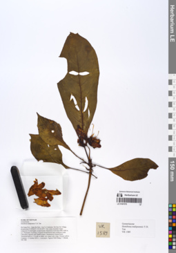
LE 01067078
Hemiboea malipoensis Y.H.Tan det. Averyanov, Leonid Vladimirovich at 10.12.2019
Collectors: Averyanov, Leonid Vladimirovich; Khang Sinh Nguyen; Maisak, Tatiana Viktorovna Field collecting number: VR1589. Collection date: 11.10.2019. Administrative regions: VN - Tinh Ha Giang. Groups of specimens: L. V. Averyanov specimens; L. V. Averyanov herbariumOriginal label text:FLORA OF VIETNAM Gesneriaceae Hemiboea malipoensis Y.H. Tan Ha Giang Prov., Quan Ba Distr., Can Ty Commune, Sin Suoi Ho Village, around point 23.09566ºN 105.02142ºE. Very steep mountain slopes composed of solid highly eroded karstic limestone at elevation 800–1000 m a.s.l. Remnants of primary evergreen broad-leaved and coniferous (with Calocedrus rupestris and Xanthocyparis vietnamensis) humid forest. Terrestrial herb to 1.5 m tall on shady very steep rocky slope. Flowers yellow. Common. 11 October 2019, L. Averyanov, Nguyen Sinh Khang, T. Maisak, VR 1589.
Coordinates (geographic position): 23° 5′ 44.38″ N, 105° 1′ 17.11″ E ±1000 mRecord creation: 2019-12-31, Leonid Averyanov, PhotoScan D1Citation: Specimen LE 01067078 // Virtual herbarium of Komarov Botanical Institute RAS — http://re.herbariumle.ru/01067078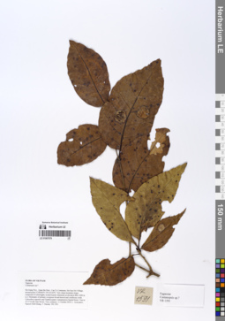
LE 01067079
Castanopsis sp. det. Averyanov, Leonid Vladimirovich at 10.12.2019
Collectors: Averyanov, Leonid Vladimirovich; Khang Sinh Nguyen; Maisak, Tatiana Viktorovna Field collecting number: VR1591. Collection date: 11.10.2019. Administrative regions: VN - Tinh Ha Giang. Groups of specimens: L. V. Averyanov specimens; L. V. Averyanov herbarium; Images of plants from the Indochinese Peninsula (Cambodia, Laos, Thailand, Vietnam and surrounding areas)Original label text:FLORA OF VIETNAM
Coordinates (geographic position): 23° 5′ 44.38″ N, 105° 1′ 17.11″ E ±1000 mRecord creation: 2019-12-31, Leonid Averyanov, PhotoScan D1. Processing status: work_status_1Citation: Specimen LE 01067079 // Virtual herbarium of Komarov Botanical Institute RAS — http://re.herbariumle.ru/01067079Fagaceae
Castanopsis sp.?
Ha Giang Prov., Quan Ba Distr., Can Ty Commune, Sin Suoi Ho Village, around point 23.09566ºN 105.02142ºE. Very steep mountain slopes composed of solid highly eroded karstic limestone at elevation 800–1000 m a.s.l. Remnants of primary evergreen broad-leaved and coniferous (with Calocedrus rupestris and Xanthocyparis vietnamensis) humid forest. Tree to 12-15 m tall, bars brown. Very common. 11 October 2019, L. Averyanov, Nguyen Sinh Khang, T. Maisak, VR 1591.
LE 01067080
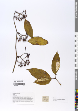
Cayratia corniculata Gagnep. det. Averyanov, Leonid Vladimirovich at 10.12.2019
Collectors: Averyanov, Leonid Vladimirovich; Khang Sinh Nguyen; Maisak, Tatiana Viktorovna Field collecting number: VR1592. Collection date: 11.10.2019. Administrative regions: VN - Tinh Ha Giang. Groups of specimens: L. V. Averyanov specimens; L. V. Averyanov herbariumOriginal label text:FLORA OF VIETNAM Vitaceae Cayratia corniculata Gagnep. Ha Giang Prov., Quan Ba Distr., Can Ty Commune, Sin Suoi Ho Village, around point 23.09566ºN 105.02142ºE. Very steep mountain slopes composed of solid highly eroded karstic limestone at elevation 800–1000 m a.s.l. Remnants of primary evergreen broad-leaved and coniferous (with Calocedrus rupestris and Xanthocyparis vietnamensis) humid forest. Herbaceous or semiwoody vine to 4 m long in open rocky place. Fruits white. Common. 11 October 2019, L. Averyanov, Nguyen Sinh Khang, T. Maisak, VR 1592.
Coordinates (geographic position): 23° 5′ 44.38″ N, 105° 1′ 17.11″ E ±1000 mRecord creation: 2019-12-31, Leonid Averyanov, PhotoScan D1Citation: Specimen LE 01067080 // Virtual herbarium of Komarov Botanical Institute RAS — http://re.herbariumle.ru/01067080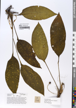
LE 01067134
Holotype of Aspidistra obliqua K.S. Nguyen & Aver. det. Averyanov, Leonid Vladimirovich at 11.10.2019
Collectors: Averyanov, Leonid Vladimirovich; Khang Sinh Nguyen; Maisak, Tatiana Viktorovna Field collecting number: VR1548. Collection date: 11.10.2019. Administrative regions: VN - Tinh Ha Giang. Groups of specimens: L. V. Averyanov specimens; L. V. Averyanov herbarium; L. V. Averyanov photosOriginal label text:FLORA OF VIETNAM Convallariaceae Aspidistra obliqua K.S. Nguyen & Aver., sp. nov. Ha Giang Prov., Quan Ba Distr., Can Ty Commune, Sin Suoi Ho Village, around point 23.09566ºN 105.02142ºE. Very steep mountain slopes composed of solid highly eroded karstic limestone at elevation 800–1000 m a.s.l. Remnants of primary evergreen broad-leaved and coniferous (with Calocedrus rupestris and Xanthocyparis vietnamensis) humid forest. Terrestrial rhizomatous herb in shady place among rocks. Leaves rigid, velvety dark green with unclear yellowish spots, pale green below. Flowers almost entirely black, stigma at apex yellow, below black. Not common. 11 October 2019, L. Averyanov, Nguyen Sinh Khang, T. Maisak, VR 1548 (holotype – LE 01067134, isotype – HN).
Coordinates (geographic position): 23° 5′ 44.38″ N, 105° 1′ 17.11″ E ±1000 mComment: From most close Aspidistra clausa var. latifolia and A. zhangii new species differs in velvetyleaves, almost black perianth lobes, 1–3 filaments fused with stile andstrongly oblique pistil with light yellowish transversely elliptic or circularunlobed stigma.
Record creation: 2019-12-31, Leonid Averyanov, PhotoScan D1Citation: Specimen LE 01067134 // Virtual herbarium of Komarov Botanical Institute RAS — http://re.herbariumle.ru/01067134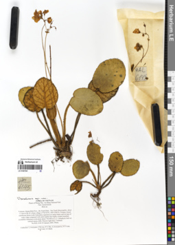
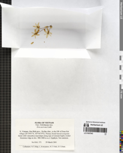
LE 01067541
Isotype of Paraboea stellata D.J.Middleton det. Khang Sinh Nguyen at 17.02.2020
Additional identifications: Paraboea sp. det. Averyanov, Leonid Vladimirovich at 25.01.2005 Collectors: Averyanov, Leonid Vladimirovich; et al. Field collecting number: HAL6145. Collection date: 25.01.2005. Administrative regions: VN - Tinh Quang Binh. Groups of specimens: L. V. Averyanov specimens; L. V. Averyanov herbariumOriginal label text:FLORA OF VIETNAM
Plants of Phong Nha - Ke Bang National Park
Fam. Gesneriaceae
Boea sp.
Vietnam, Quang Binh Prov., Bo Trach Distr., Tan Trach Municipality, about 1.5 km to SE of A Rem village (17º23'32''N, 106º12'46''E). Primary closed coniferous forest (with Calocedrus rupestris) on steep slopes and on tops of rocky ridge composed with solid marble-like highly eroded stratified crystalline limestone at elevation about 750-900 m a.s.l. Lithophytic herb on vertical mossy cliffs. Flowers light blue. Common.
No HAL 6145 25 January 2005. Photo.
Collectors: L.Averyanov, P.K.Loc, P.V.The, A.Averyanova, N.T.Vinh, N.Q.Vinh, N.T.Binh.
New species?
Record creation: 2020-02-07, Leonid Averyanov, PhotoScan D1Citation: Specimen LE 01067541 // Virtual herbarium of Komarov Botanical Institute RAS — http://re.herbariumle.ru/01067541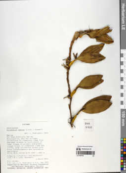
LE 01067872
Epigeneium amplum (Lindl.) Summerh. det. Averyanov, Leonid Vladimirovich at 06.03.2001
Collectors: D.K. Harder; Phan Ke Loc; Averyanov, Leonid Vladimirovich; Nguyen Xuan Tam Field collecting number: DKH7373. Collection date: 06.03.2001. Administrative regions: VN - Tinh Son La. Groups of specimens: L. V. Averyanov specimens; L. V. Averyanov herbarium; Orchids of Vietnam, Laos and CambodiaOriginal label text:FLORA OF VIETNAM
Orchidaceae Juss.
Epigeneium amplum (Lindl.) Summerhayes
N. Vietnam, Son La prov., Moc Chau distr., Van Ho municipality, near
Hua Tat village (20°46′35′'N, 104°46′31′'E). Coniferous forest with
Pinus kwangtungensis, Podocarpus sp. and Calocedrus macrolepis along
remnant limestone highly eroded ridge at elev. 1400-1500 m a.s.l.
Creeping lithophytic and epiphytic vine 1-2 m lg. Abundant.
DKH 7373 6 March 2001
Collectors:D.K.Harder, P.K.Loc, N.X.Tam, L. Averyanov.
LE 01067878
Epigeneium amplum (Lindl.) Summerh. det. Averyanov, Leonid Vladimirovich at 05.11.2006
Collectors: Tien Hiep Nguyen; Averyanov, Leonid Vladimirovich; The Van Pham Field collecting number: HAL9552. Collection date: 05.11.2006. Administrative regions: VN - Tinh Son La. Groups of specimens: L. V. Averyanov specimens; L. V. Averyanov herbarium; Orchids of Vietnam, Laos and CambodiaOriginal label text:FLORA OF VIETNAM
Orchidaceae
Epigeneium amplum (Lindl.) Summerh.
Son La Prov., Yen Chau Distr., Muong Lum Municipality, Na Hat village, around point 21°00′37″N 104°30′06″E.
Broad-leaved (and former coniferous forest with Calocedrus rupestris) evergreen forest on steep slopes and on tops of ridge composed with rocky crystalline solid marble-like highly eroded limestone at elev. 900 m a.s.l.
Creeping lithophyte on shady rocky slope. Flowers white to yellowish, lip dirty violet. Very common.
HAL 9552 05 Nov. 2006
Coll.: Nguyen Tien Hiep, L.Averyanov, Pham Van The.
LE 01067921
Epigeneium clemensiae Gagnep. det. Averyanov, Leonid Vladimirovich at 25.12.2022
Additional identifications: Epigeneium chapaense Gagnep. det. Averyanov, Leonid Vladimirovich at 06.03.2001 Collectors: D.K. Harder; Phan Ke Loc; Averyanov, Leonid Vladimirovich; Nguyen Xuan Tam Field collecting number: DKH7370. Collection date: 06.03.2001. Administrative regions: VN - Tinh Son La. Groups of specimens: L. V. Averyanov specimens; L. V. Averyanov herbarium; Orchids of Vietnam, Laos and CambodiaOriginal label text:FLORA OF VIETNAM
Orchidaceae Juss.
Epigeneium chapaense Gagnep.
N. Vietnam, Son La prov., Moc Chau distr., Van Ho municipality, near
Hua Tat village (20°46′35′'N, 104°46′31′'E). Coniferous forest with
Pinus kwangtungensis, Podocarpus sp. and Calocedrus macrolepis along
remnant limestone highly eroded ridge at elev. 1400-1500 m a.s.l.
Epiphyte. Abundant.
DKH 7370 6 March 2001
Collectors:D.K.Harder, P.K.Loc, N.X.Tam, L. Averyanov.
LE 01067943
Eria acervata Lindl. det. Averyanov, Leonid Vladimirovich at 29.03.2001
Collectors: Tien Hiep Nguyen; Averyanov, Leonid Vladimirovich; N.T.Vinh; D.T. Doan Field collecting number: HAL373. Collection date: 29.03.2001. Administrative regions: VN - Tinh Hoa Binh. Groups of specimens: L. V. Averyanov specimens; L. V. Averyanov herbarium; Orchids of Vietnam, Laos and CambodiaOriginal label text:FLORA OF VIETNAM
Orchidaceae Juss.
Eria acervata Lindl.
N. Vietnam, Hoa Binh prov., Da Bac distr., to the SW of Doan Ket village (20°54′01′'N, 105°04′19′'E). Primary broad-leaved evergreen forest with Calocedrus rupestris (?) along tops of remnant highly eroded limestone ridge at elev. 900-1000 m a.s.l. Epiphyte. Not common.
HAL 373 29 March 2001
Collectors: N.T.Hiep, L.Averyanov, N.T.Vinh, D.T.Doan.
LE 01068122
Eria coronaria (Lindl.) Rchb.f.
Collectors: Averyanov, Leonid Vladimirovich; et al. Field collecting number: HAL9502. Collection date: 04.11.2006. Administrative regions: VN - Tinh Son La. Groups of specimens: L. V. Averyanov specimens; L. V. Averyanov herbarium; Orchids of Vietnam, Laos and CambodiaOriginal label text:FLORA OF VIETNAM
Orchidaceae
Eria coronaria (Lindl.) Rchb.f.
Son La Prov., Yen Chau Distr., Muong Lum Municipality, Xao village, around point 20°59′54″N 104°38′47″E.
Broad-leaved and coniferous (with Pinus kwangtungensis and Calocedrus rupestris) evergreen forest on steep slopes and on tops of ridge composed with rocky crystalline solid marble-like highly eroded limestone at elev. 1100-1300 m a.s.l.
Lithophytic herb on mossy rocks along ridge edge. Flowers white, lip with purple striped side-lobes and yellow center. Very common.
HAL 9502 04 Nov. 2006
Coll.: Nguyen Tien Hiep, L.Averyanov, Pham Van The.
Coordinates (geographic position): 20° 59′ 54″ N, 104° 38′ 47″ E ±1000 mRecord creation: 2020-06-26, Leonid Averyanov, PhotoScan D1. Processing status: work_status_1Citation: Specimen LE 01068122 // Virtual herbarium of Komarov Botanical Institute RAS — http://re.herbariumle.ru/01068122Orchidaceae
Eria coronaria (Lindl.) Rchb.f.
Son La Prov., Yen Chau Distr., Muong Lum Municipality, Xao village, around point 20°59′54″N 104°38′47″E.
Broad-leaved and coniferous (with Pinus kwangtungensis and Calocedrus rupestris) evergreen forest on steep slopes and on tops of ridge composed with rocky crystalline solid marble-like highly eroded limestone at elev. 1100-1300 m a.s.l.
Lithophytic herb on mossy rocks along ridge edge. Flowers white, lip with purple striped side-lobes and yellow center. Very common.
HAL 9502 04 Nov. 2006
Coll.: Nguyen Tien Hiep, L.Averyanov, Pham Van The.
LE 01068144
Eria coronaria (Lindl.) Rchb.f. det. Averyanov, Leonid Vladimirovich at 06.03.2001
Collectors: D.K. Harder; Phan Ke Loc; Averyanov, Leonid Vladimirovich; Nguyen Xuan Tam Field collecting number: DKH7362. Collection date: 06.03.2001. Administrative regions: VN - Tinh Son La. Groups of specimens: L. V. Averyanov specimens; L. V. Averyanov herbarium; Orchids of Vietnam, Laos and CambodiaOriginal label text:FLORA OF VIETNAM
Orchidaceae Juss.
Eria coronaria (Lindl.) Rchb.f.
N. Vietnam, Son La prov., Moc Chau distr., Van Ho municipality, near
Hua Tat village (20°46′35′'N, 104°46′31′'E). Coniferous forest with
Pinus kwangtungensis, Podocarpus sp. and Calocedrus macrolepis along
remnant limestone highly eroded ridge at elev. 1400-1500 m a.s.l.
Lithophyte. Abundant.
DKH 7362 6 March 2001
Collectors:D.K.Harder, P.K.Loc, N.X.Tam, L. Averyanov.
LE 01068536
Eria foetida Aver.
Collectors: Averyanov, Leonid Vladimirovich; et al. Field collecting number: DKH7367. Collection date: 06.03.2001. Administrative regions: VN - Tinh Son La. Groups of specimens: L. V. Averyanov specimens; L. V. Averyanov herbarium; Orchids of Vietnam, Laos and CambodiaOriginal label text:FLORA OF VIETNAM
Orchidaceae Juss.
Eria foetida Aver.
N. Vietnam, Son La prov., Moc Chau distr., Van Ho municipality, near
Hua Tat village (20°46′35′'N, 104°46′31′'E). Coniferous forest with
Pinus kwangtungensis, Podocarpus sp. and Calocedrus macrolepis along
remnant limestone highly eroded ridge at elev. 1400-1500 m a.s.l.
Epiphyte. Flowers with sweetish unpleasant smell, yellow, tip of the
lip purple-violet. Very common.
DKH 7367 6 March 2001
Collectors: P.K.Loc, N.X.Tam, L. Averyanov.
Coordinates (geographic position): 20° 46′ 35″ N, 104° 46′ 31″ E ±1000 mRecord creation: 2020-06-26, Leonid Averyanov, PhotoScan D1. Processing status: work_status_1Citation: Specimen LE 01068536 // Virtual herbarium of Komarov Botanical Institute RAS — http://re.herbariumle.ru/01068536Orchidaceae Juss.
Eria foetida Aver.
N. Vietnam, Son La prov., Moc Chau distr., Van Ho municipality, near
Hua Tat village (20°46′35′'N, 104°46′31′'E). Coniferous forest with
Pinus kwangtungensis, Podocarpus sp. and Calocedrus macrolepis along
remnant limestone highly eroded ridge at elev. 1400-1500 m a.s.l.
Epiphyte. Flowers with sweetish unpleasant smell, yellow, tip of the
lip purple-violet. Very common.
DKH 7367 6 March 2001
Collectors: P.K.Loc, N.X.Tam, L. Averyanov.
LE 01068720
Eria pannea Lindl. det. Averyanov, Leonid Vladimirovich at 25.01.2005
Collectors: Averyanov, Leonid Vladimirovich; et al. Field collecting number: HAL6118. Collection date: 25.01.2005. Administrative regions: VN - Tinh Quang Binh. Groups of specimens: L. V. Averyanov specimens; L. V. Averyanov herbarium; Orchids of Vietnam, Laos and CambodiaOriginal label text:FLORA OF VIETNAM
Plants of Phong Nha - Ke Bang National Park
Orchidaceae
Eria pannea Lindl.
Vietnam, Quang Binh Prov., Bo Trach Distr., Tan Trach Municipality, about 1.5 km to SE of A Rem village (17°23′32′'N, 106°12′46′'E).
Primary closed coniferous forest (with Calocedrus rupestris) on steep slopes and on tops of rocky ridge composed with solid marble-like highly eroded stratified crystalline limestone at elevation about 750-900 m a.s.l.
Creeping epiphyte on high trees on Calocedrus rupestris and Podocarpus neriifolius. Not common.
HAL 6118 25 January 2005.
Collectors: L.Averyanov, P.K.Loc, P.V.The, A.Averyanova, N.T.Vinh, N.Q.Vinh, N.T.Binh.
LE 01068806
Eria rhomboidalis Tang & F.T.Wang det. Averyanov, Leonid Vladimirovich at 08.12.2021
Additional identifications: Epigeneium labuanum (Lindl.) Summerh. det. Averyanov, Leonid Vladimirovich at 25.01.2005 Collectors: Averyanov, Leonid Vladimirovich; et al. Field collecting number: HAL6123. Collection date: 25.01.2005. Administrative regions: VN - Tinh Quang Binh. Groups of specimens: L. V. Averyanov specimens; L. V. Averyanov herbarium; Orchids of Vietnam, Laos and CambodiaOriginal label text:FLORA OF VIETNAM
Plants of Phong Nha - Ke Bang National Park
Orchidaceae
Epigeneium labuanum (Lindl.) Summerh.
Vietnam, Quang Binh Prov., Bo Trach Distr., Tan Trach Municipality, about 1.5 km to SE of A Rem village (17°23′32′'N, 106°12′46′'E). Primary closed coniferous forest (with Calocedrus rupestris) on steep slopes and on tops of rocky ridge composed with solid marble-like highly eroded stratified crystalline limestone at elevation about 750-900 m a.s.l. Creeping lithophyte and epiphyte (Calocedrus rupestris, Podocarpus neriifolius). Very common.
HAL 6123 25 January 2005. Photo.
Collectors: L.Averyanov, P.K.Loc, P.V.The, A.Averyanova, N.T.Vinh, N.Q.Vinh, N.T.Binh.
Coordinates (geographic position): 17° 23′ 32″ N, 106° 12′ 46″ E ±1000 mRecord creation: 2020-09-03, Leonid Averyanov, PhotoScan D2. Processing status: work_status_1Citation: Specimen LE 01068806 // Virtual herbarium of Komarov Botanical Institute RAS — http://re.herbariumle.ru/01068806Plants of Phong Nha - Ke Bang National Park
Orchidaceae
Epigeneium labuanum (Lindl.) Summerh.
Vietnam, Quang Binh Prov., Bo Trach Distr., Tan Trach Municipality, about 1.5 km to SE of A Rem village (17°23′32′'N, 106°12′46′'E). Primary closed coniferous forest (with Calocedrus rupestris) on steep slopes and on tops of rocky ridge composed with solid marble-like highly eroded stratified crystalline limestone at elevation about 750-900 m a.s.l. Creeping lithophyte and epiphyte (Calocedrus rupestris, Podocarpus neriifolius). Very common.
HAL 6123 25 January 2005. Photo.
Collectors: L.Averyanov, P.K.Loc, P.V.The, A.Averyanova, N.T.Vinh, N.Q.Vinh, N.T.Binh.
LE 01068827
Eria rhomboidalis Tang & F.T.Wang det. Averyanov, Leonid Vladimirovich at 08.12.2021
Additional identifications: Epigeneium labuanum (Lindl.) Summerh. det. Averyanov, Leonid Vladimirovich at 06.03.2001 Collectors: D.K. Harder; et al. Field collecting number: DKH7360. Collection date: 06.03.2001. Administrative regions: VN - Tinh Son La. Groups of specimens: L. V. Averyanov specimens; L. V. Averyanov herbarium; Orchids of Vietnam, Laos and CambodiaOriginal label text:FLORA OF VIETNAM
Orchidaceae Juss.
Epigeneium labuanum (Lindl.) Summerhayes
N. Vietnam, Son La prov., Moc Chau distr., Van Ho municipality, near Hua Tat village (20°46′35′'N, 104°46′31′'E). Coniferous forest with Pinus kwangtungensis, Podocarpus sp. and Calocedrus macrolepis along remnant limestone highly eroded ridge at elev. 1400-1500 m a.s.l. Lithophyte and epiphyte. Tepals white with pink tint, Lip with yellow spot at the center and brownish-purple keels. Abundant.
DKH 7360 6 March 2001
Collectors: P.K.Loc, N.X.Tam, L. Averyanov.
LE 01068828
Eria rhomboidalis Tang & F.T.Wang det. Averyanov, Leonid Vladimirovich at 07.12.2021
Additional identifications: Epigeneium amplum (Lindl.) Summerh. Collectors: D.K. Harder; et al. Field collecting number: DKH7373a. Collection date: 06.03.2001. Administrative regions: VN - Tinh Son La. Groups of specimens: L. V. Averyanov specimens; L. V. Averyanov herbarium; Orchids of Vietnam, Laos and CambodiaOriginal label text:FLORA OF VIETNAM
Orchidaceae Juss.
Epigeneium amplum (Lindl.) Summerhayes
N. Vietnam, Son La prov., Moc Chau distr., Van Ho municipality, near
Hua Tat village (20°46′35′'N, 104°46′31′'E). Coniferous forest with
Pinus kwangtungensis, Podocarpus sp. and Calocedrus macrolepis along
remnant limestone highly eroded ridge at elev. 1400-1500 m a.s.l.
Creeping lithophytic and epiphytic vine 1-2 m lg. Abundant.
DKH 7373a 6 March 2001
Collectors: P.K.Loc, N.X.Tam, L. Averyanov.
Coordinates (geographic position): 20° 46′ 35″ N, 104° 46′ 31″ E ±1000 mRecord creation: 2020-09-03, Leonid Averyanov, PhotoScan D2. Processing status: work_status_1Citation: Specimen LE 01068828 // Virtual herbarium of Komarov Botanical Institute RAS — http://re.herbariumle.ru/01068828Orchidaceae Juss.
Epigeneium amplum (Lindl.) Summerhayes
N. Vietnam, Son La prov., Moc Chau distr., Van Ho municipality, near
Hua Tat village (20°46′35′'N, 104°46′31′'E). Coniferous forest with
Pinus kwangtungensis, Podocarpus sp. and Calocedrus macrolepis along
remnant limestone highly eroded ridge at elev. 1400-1500 m a.s.l.
Creeping lithophytic and epiphytic vine 1-2 m lg. Abundant.
DKH 7373a 6 March 2001
Collectors: P.K.Loc, N.X.Tam, L. Averyanov.
LE 01068917
Eria stricta Lindl. det. Averyanov, Leonid Vladimirovich at 06.12.2005
Collectors: Averyanov, Leonid Vladimirovich; et al. Field collecting number: HAL8348. Collection date: 06.12.2005. Administrative regions: VN - Tinh Ha Giang. Groups of specimens: L. V. Averyanov specimens; L. V. Averyanov herbarium; Orchids of Vietnam, Laos and CambodiaOriginal label text:FLORA OF VIETNAM
Orchidaceae
Eria stricta Lindl.
Vietnam, Ha Giang Prov., Quan Ba Distr, about 2 km to the NE of Quan Ba town, around point 23°05′49″N, 105°01′00″E at elevation about 1150 m a.s.l.
Primary coniferous forest with Calocedrus rupestris, Callitropsis vietnamensis and Pseudotsuga sinensis on rocky highly eroded marble-like limestone remnant mountains.
Epiphyte on mossy trees on shady wet rocky mossy slope. Flowers yellowish, lip white with purple marks. Very common.
HAL 8348 6 Dec 2005. Photo.
Collectors: L.Averyanov, P.K.Loc, T.V.Thao, P.V.The, N.S.Khang.
LE 01069103
Gastrochilus acutifolius (Lindl.) Kuntze det. Averyanov, Leonid Vladimirovich at 05.11.2006
Collectors: Tien Hiep Nguyen; Averyanov, Leonid Vladimirovich; The Van Pham Field collecting number: HAL9537. Collection date: 05.11.2006. Administrative regions: VN - Tinh Son La. Groups of specimens: L. V. Averyanov specimens; L. V. Averyanov herbarium; Orchids of Vietnam, Laos and CambodiaOriginal label text:FLORA OF VIETNAM
Orchidaceae
Gastrochilus acutifolius(Lindl.) Kuentze
Son La Prov., Yen Chau Distr., Muong Lum Municipality, Na Hat village, around point 21°00′37″N 104°30′06″E.
Broad-leaved (and former coniferous forest with Calocedrus rupestris) evergreen forest on steep slopes and on tops of ridge composed with rocky crystalline solid marble-like highly eroded limestone at elev. 900 m a.s.l.
Epiphyte in wet shady stream valley. Tepals yellow with brown-purple marks. Lip white. Not common.
HAL 9537 05 Nov. 2006 Photo.
Coll.: Nguyen Tien Hiep, L.Averyanov, Pham Van The.
LE 01069124
Gastrochilus calceolaris (Sm.) D.Don det. Averyanov, Leonid Vladimirovich at 26.02.2004
Collectors: Vo Minh Son; Vinh Tien Nguyen Field collecting number: HLF3138. Collection date: 26.02.2004. Administrative regions: VN - Tinh Nghe An. Groups of specimens: L. V. Averyanov specimens; L. V. Averyanov herbarium; Orchids of Vietnam, Laos and CambodiaOriginal label text:FLORA OF VIETNAM
Plants of the Pu Huong Nature Reserve
Orchidaceae
Gastrochilus calceolaris (Sm.) D.Don
Nghe An Prov., Con Cuong Distr., Binh Chuan Municipality, top ridge of Pu Pha Cau limestone mt., 19(18′13.3′'N, 104(53′50.2′'E, ca 1100-1250 m a.s.l. Epiphyte on trees in forest with the dominance of Calocedrus rupestris. Flowers yellow with red traces.
Collectors: Vo Minh Son, Nguyen Tien Vinh.
HLF 3138 26 Feb 2004
Collected with financial support from Luce Foundation (U.S.A)
Record creation: 2020-09-12, Leonid Averyanov, PhotoScan D2. Processing status: work_status_1Citation: Specimen LE 01069124 // Virtual herbarium of Komarov Botanical Institute RAS — http://re.herbariumle.ru/01069124Plants of the Pu Huong Nature Reserve
Orchidaceae
Gastrochilus calceolaris (Sm.) D.Don
Nghe An Prov., Con Cuong Distr., Binh Chuan Municipality, top ridge of Pu Pha Cau limestone mt., 19(18′13.3′'N, 104(53′50.2′'E, ca 1100-1250 m a.s.l. Epiphyte on trees in forest with the dominance of Calocedrus rupestris. Flowers yellow with red traces.
Collectors: Vo Minh Son, Nguyen Tien Vinh.
HLF 3138 26 Feb 2004
Collected with financial support from Luce Foundation (U.S.A)