View
Add
Copy
Edit
Delete
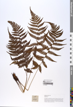
LE 01055394
Athyrium christensenii Tard. det. X.C.Zhang at 05.07.2019
Additional identifications: Diplazium sp. det. Averyanov, Leonid Vladimirovich at 21.10.2018 Collectors: Averyanov, Leonid Vladimirovich; Khang Sinh Nguyen; Maisak, Tatiana Viktorovna; Truong Duc Thieu Field collecting number: VR1144. Collection date: 21.10.2018. Administrative regions: VN - Tinh Ha Giang. Groups of specimens: L. V. Averyanov specimens; L. V. Averyanov herbarium; L. V. Averyanov photosOriginal label text:FLORA OF VIETNAM
Coordinates (geographic position): 23° 4′ 47.2″ N, 104° 48′ 55.6″ E ±1000 mComment: Polypodiaceae s.l.
Athyriaceae
Athyrium christensenii Tard.
Ha Giang prov., Quan Ba distr., Cao Ma Po commune, Chin Chu Lin village, around point 23º04ʹ47.2ʺN 104º48ʹ55.6ʺE, steep slopes and flattened top of mountain composed with sandstone at elevation 1800–1950 m a.s.l. Primary evergreen broad-leaved very humid forest. Terrestrial fern on shady mossy steep slope. Common. 21 October 2018, L. Averyanov, Nguyen Sinh Khang, T. Maisak, Truong Duc Thieu, VR 1144.
All photos © L. Averyanov & K.S. Nguyen
Record creation: 2019-06-11, Leonid Averyanov, PhotoScan D1Citation: Specimen LE 01055394 // Virtual herbarium of Komarov Botanical Institute RAS — http://re.herbariumle.ru/01055394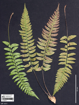
LE 01061107
Diplazium pullingeri (Baker) J.Sm. det. Averyanov, Leonid Vladimirovich at 07.10.2019
Collectors: Averyanov, Leonid Vladimirovich; Khang Sinh Nguyen; Maisak, Tatiana Viktorovna Field collecting number: VR1411a. Collection date: 07.10.2019. Administrative regions: VN - Tinh Ha Giang. Groups of specimens: L. V. Averyanov specimens; L. V. Averyanov photosOriginal label text:FLORA OF VIETNAM Polypodiaceae s.l. (Athyriaceae) Diplazium pullingeri (Baker) J. Sm.? Ha Giang Prov., Quan Ba Distr., Tung Vai Commune, Thang Village, around point 23.05349ºN 104.86446ºE, steep rocky slopes of river valley composed with eroded limestone mixed with sandstone at elevation 1000–1100 m a.s.l. Remnants of primary evergreen broad-leaved very humid forest along river. Lithophytic fern on wet mossy stream rocks. Common. 7 October 2019, L. Averyanov, Nguyen Sinh Khang, T. Maisak, VR 1411a.
Coordinates (geographic position): 23° 3′ 12.56″ N, 104° 51′ 52.06″ E ±1000 mComment: All photos © L. Averyanov & K.S. Nguyen
Record creation: 2019-12-31, Аверьянов Леонид ВладимировичCitation: Specimen LE 01061107 // Virtual herbarium of Komarov Botanical Institute RAS — http://re.herbariumle.ru/01061107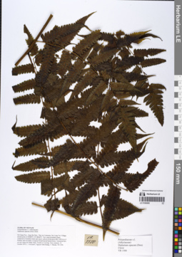
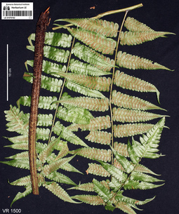
LE 01066985
Cornopteris opaca D.Don det. Averyanov, Leonid Vladimirovich at 19.02.2020
Additional identifications: Diplazium opacum (Don) Christ det. Averyanov, Leonid Vladimirovich at 10.12.2019 Collectors: Averyanov, Leonid Vladimirovich; Khang Sinh Nguyen; Maisak, Tatiana Viktorovna Field collecting number: VR1500. Collection date: 10.10.2019. Administrative regions: VN - Tinh Ha Giang. Groups of specimens: L. V. Averyanov specimens; L. V. Averyanov herbariumOriginal label text:FLORA OF VIETNAM Polypodiaceae s.l. (Athyriaceae) Diplazium opacum (Don) Christ Ha Giang Prov., Quan Ba Distr., Thai An Commune, Seo Lung Two Village, around point 22.96988ºN 105.08646ºE. Very steep mountain slopes composed of stratified shale and clayey subsoil at elevation 800–1000 m a.s.l. Primary and secondary evergreen broad-leaved humid forest. Terrestrial fern on very steep wet shady slope. Fronds to 2 m long. Very common. 10 October 2019, L. Averyanov, Nguyen Sinh Khang, T. Maisak, VR 1500.
Coordinates (geographic position): 22° 58′ 11.57″ N, 105° 5′ 11.26″ E ±1000 mRecord creation: 2019-12-31, Leonid Averyanov, PhotoScan D1Citation: Specimen LE 01066985 // Virtual herbarium of Komarov Botanical Institute RAS — http://re.herbariumle.ru/01066985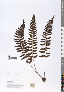
LE 01067001
Diplazium pullingeri (Baker) J.Sm. det. Averyanov, Leonid Vladimirovich at 10.12.2019
Collectors: Averyanov, Leonid Vladimirovich; Khang Sinh Nguyen; Maisak, Tatiana Viktorovna Field collecting number: VR1411a. Collection date: 07.10.2019. Administrative regions: VN - Tinh Ha Giang. Groups of specimens: L. V. Averyanov specimens; L. V. Averyanov herbariumOriginal label text:FLORA OF VIETNAM Polypodiaceae s.l. (Athyriaceae) Diplazium pullingeri (Baker) J. Sm.? Ha Giang Prov., Quan Ba Distr., Tung Vai Commune, Thang Village, around point 23.05349ºN 104.86446ºE, steep rocky slopes of river valley composed with eroded limestone mixed with sandstone at elevation 1000–1100 m a.s.l. Remnants of primary evergreen broad-leaved very humid forest along river. Lithophytic fern on wet mossy stream rocks. Common. 7 October 2019, L. Averyanov, Nguyen Sinh Khang, T. Maisak, VR 1411a.
Coordinates (geographic position): 23° 3′ 12.56″ N, 104° 51′ 52.06″ E ±1000 mRecord creation: 2019-12-31, Leonid Averyanov, PhotoScan D1Citation: Specimen LE 01067001 // Virtual herbarium of Komarov Botanical Institute RAS — http://re.herbariumle.ru/01067001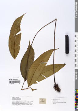
LE 01067120
Diplazium crassiusculum Ching det. Averyanov, Leonid Vladimirovich at 20.12.2019
Collectors: Averyanov, Leonid Vladimirovich; Khang Sinh Nguyen; Maisak, Tatiana Viktorovna Field collecting number: VR1527. Collection date: 10.10.2019. Administrative regions: VN - Tinh Ha Giang. Groups of specimens: L. V. Averyanov specimens; L. V. Averyanov herbariumOriginal label text:FLORA OF VIETNAM Polypodiaceae s.l. (Athyriaceae) Diplazium crassiusculum Ching Ha Giang Prov., Quan Ba Distr., Thai An Commune, Seo Lung Two Village, around point 22.96988ºN 105.08646ºE. Very steep mountain slopes composed of stratified shale and clayey subsoil at elevation 800–1000 m a.s.l. Primary and secondary evergreen broad-leaved humid forest. Terrestrial fern on steep shady slope. Common. 10 October 2019, L. Averyanov, Nguyen Sinh Khang, T. Maisak, VR 1527.
Coordinates (geographic position): 22° 58′ 11.57″ N, 105° 5′ 11.26″ E ±1000 mRecord creation: 2019-12-31, Leonid Averyanov, PhotoScan D1Citation: Specimen LE 01067120 // Virtual herbarium of Komarov Botanical Institute RAS — http://re.herbariumle.ru/01067120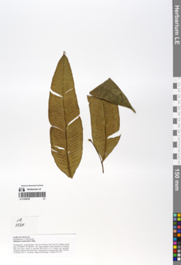
LE 01068358
Diplazium crassiusculum Ching det. Averyanov, Leonid Vladimirovich at 10.10.2019
Collectors: Averyanov, Leonid Vladimirovich; et al. Field collecting number: VR1527. Collection date: 10.10.2019. Administrative regions: VN - Tinh Ha Giang. Groups of specimens: L. V. Averyanov specimens; L. V. Averyanov herbariumOriginal label text:FLORA OF VIETNAM
Polypodiaceae s.l. (Athyriaceae)
Diplazium crassiusculum Ching
LE 01070182
Diplazium opacum (Don) Christ det. Averyanov, Leonid Vladimirovich at 10.12.2019
Additional identifications: Cornopteris opaca D.Don det. Averyanov, Leonid Vladimirovich at 19.02.2020 Collectors: Averyanov, Leonid Vladimirovich; Khang Sinh Nguyen; Maisak, Tatiana Viktorovna Field collecting number: VR1500. Collection date: 10.10.2019. Administrative regions: VN - Tinh Ha Giang. Groups of specimens: L. V. Averyanov specimens; L. V. Averyanov photosOriginal label text:FLORA OF VIETNAM
Coordinates (geographic position): 22° 58′ 11.57″ N, 105° 5′ 11.26″ E ±1000 mComment: Polypodiaceae s.l. (Athyriaceae)
Diplazium opacum (Don) Christ
Ha Giang Prov., Quan Ba Distr., Thai An Commune, Seo Lung Two Village, around point 22.96988ºN 105.08646ºE. Very steep mountain slopes composed of stratified shale and clayey subsoil at elevation 800–1000 m a.s.l. Primary and secondary evergreen broad-leaved humid forest. Terrestrial fern on very steep wet shady slope. Fronds to 2 m long. Very common. 10 October 2019, L. Averyanov, Nguyen Sinh Khang, T. Maisak, VR 1500.
All photos © L. Averyanov & K.S. Nguyen
Record creation: 2020-01-03, Аверьянов Леонид ВладимировичCitation: Specimen LE 01070182 // Virtual herbarium of Komarov Botanical Institute RAS — http://re.herbariumle.ru/01070182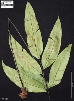
LE 01070233
Diplazium crassiusculum Ching det. Averyanov, Leonid Vladimirovich at 10.12.2019
Collectors: Averyanov, Leonid Vladimirovich; Khang Sinh Nguyen; Maisak, Tatiana Viktorovna Field collecting number: VR1527. Collection date: 10.10.2019. Administrative regions: VN - Tinh Ha Giang. Groups of specimens: L. V. Averyanov specimens; L. V. Averyanov photosOriginal label text:FLORA OF VIETNAM
Coordinates (geographic position): 22° 58′ 11.57″ N, 105° 5′ 11.26″ E ±1000 mComment: Polypodiaceae s.l. (Athyriaceae)
Diplazium crassiusculum Ching
Ha Giang Prov., Quan Ba Distr., Thai An Commune, Seo Lung Two Village, around point 22.96988ºN 105.08646ºE. Very steep mountain slopes composed of stratified shale and clayey subsoil at elevation 800–1000 m a.s.l. Primary and secondary evergreen broad-leaved humid forest. Terrestrial fern on steep shady slope. Common. 10 October 2019, L. Averyanov, Nguyen Sinh Khang, T. Maisak, VR 1527.
All photos © L. Averyanov & K.S. Nguyen
Record creation: 2020-01-04, Аверьянов Леонид ВладимировичCitation: Specimen LE 01070233 // Virtual herbarium of Komarov Botanical Institute RAS — http://re.herbariumle.ru/01070233