View
Add
Copy
Edit
Delete
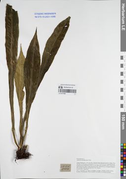
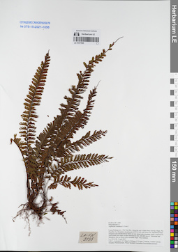
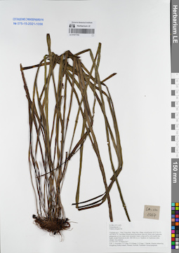
LE 01050170
Hymenasplenium unilaterale (Lam.) Hayata det. X.C.Zhang at 05.07.2019
Additional identifications: Asplenium sp. det. Averyanov, Leonid Vladimirovich at 23.04.2018; Asplenium unilaterale Lam. det. Averyanov, Leonid Vladimirovich at 23.04.2018 Collectors: Averyanov, Leonid Vladimirovich; Khang Sinh Nguyen; Tien Hiep Nguyen; Nguyen Quang Hieu; Chuong Quang Ngan; Maisak, Tatiana Viktorovna Field collecting number: VR716. Collection date: 23.04.2018. Administrative regions: VN - Tinh Ha Giang. Groups of specimens: L. V. Averyanov specimens; L. V. Averyanov herbarium; L. V. Averyanov photosOriginal label text:FLORA OF VIETNAM Polypodiaceae s.l. Asplenium sp. Ha Giang prov., Quan Ba distr., Tung Vai commune, Thang village, around point 23º03ʹ13.4ʺN 104º51ʹ48.8ʺE, steep rocky slopes of stream valley composed with eroded stratified highly eroded limestone at elevation 1000-1200 m a.s.l. Primary evergreen broad-leaved very humid forest. Lithophytic fern on moss rocks. Common. 23 April 2018, L. Averyanov, Nguyen Sinh Khang, Nguyen Tien Hiep, Nguyen Quang Hieu, Chuong Quang Ngan, T. Maisak, VR 716.
Coordinates (geographic position): 23° 3′ 13.4″ N, 104° 51′ 48.8″ E ±1000 mComment: All photos © L. Averyanov & K.S. Nguyen
Record creation: 2019-04-21, Leonid Averyanov, PhotoScan D1Citation: Specimen LE 01050170 // Virtual herbarium of Komarov Botanical Institute RAS — http://re.herbariumle.ru/01050170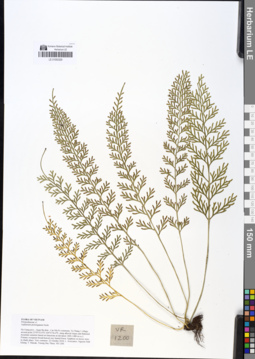
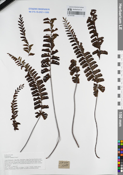
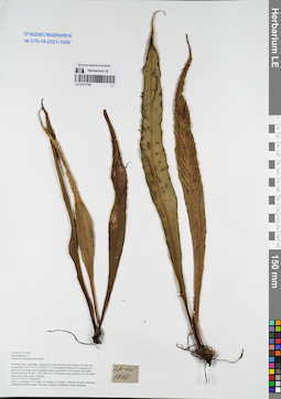
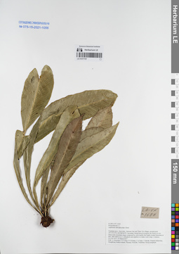
LE 01050329
Asplenium prolongatum Hook. det. Averyanov, Leonid Vladimirovich at 22.10.2018
Collectors: Averyanov, Leonid Vladimirovich; Khang Sinh Nguyen; Maisak, Tatiana Viktorovna; Truong Duc Thieu Field collecting number: VR1200. Collection date: 22.10.2018. Administrative regions: VN - Tinh Ha Giang. Groups of specimens: L. V. Averyanov specimens; L. V. Averyanov herbarium; L. V. Averyanov photosOriginal label text:FLORA OF VIETNAM Polypodiaceae s.l. Asplenium prolongatum Hook. Ha Giang prov., Quan Ba distr., Cao Ma Po commune, Va Thang 1 village, around point 23º05ʹ52.6ʺN 104º51ʹ26.4ʺE, steep alluvial slopes and flattened mountain summits based on limestone at elevation 1400–1480 m a.s.l. Primary evergreen broad-leaved very humid forest. Epiphyte on mossy trees in shady place. Very common. 22 October 2018, L. Averyanov, Nguyen Sinh Khang, T. Maisak, Truong Duc Thieu, VR 1200.
Coordinates (geographic position): 23° 5′ 52.6″ N, 104° 51′ 26.4″ E ±1000 mComment: All photos © L. Averyanov & K.S. Nguyen
Record creation: 2019-05-09, Leonid Averyanov, PhotoScan D1Citation: Specimen LE 01050329 // Virtual herbarium of Komarov Botanical Institute RAS — http://re.herbariumle.ru/01050329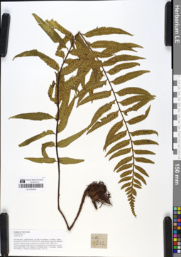
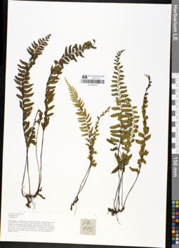
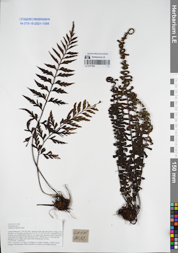
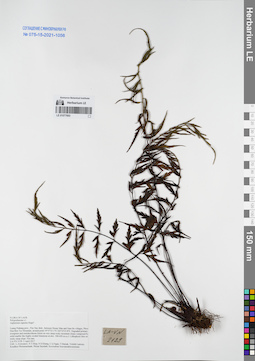
LE 01050406
Asplenium wrightii Hook. det. Averyanov, Leonid Vladimirovich at 04.07.2019
Additional identifications: Asplenium sp. det. Averyanov, Leonid Vladimirovich at 22.10.2018 Collectors: Averyanov, Leonid Vladimirovich; Khang Sinh Nguyen; Maisak, Tatiana Viktorovna; Truong Duc Thieu Field collecting number: VR1212. Collection date: 22.10.2018. Administrative regions: VN - Tinh Ha Giang. Groups of specimens: L. V. Averyanov specimens; L. V. Averyanov herbarium; L. V. Averyanov photosOriginal label text:FLORA OF VIETNAM
Coordinates (geographic position): 23° 5′ 52.6″ N, 104° 51′ 26.4″ E ±1000 mComment: Polypodiaceae s.l.
Asplenium sp.
Ha Giang prov., Quan Ba distr., Cao Ma Po commune, Va Thang 1 village, around point 23º05ʹ52.6ʺN 104º51ʹ26.4ʺE, steep alluvial slopes and flattened mountain summits based on limestone at elevation 1400–1480 m a.s.l. Primary evergreen broad-leaved very humid forest. Terrestrial fern on steep mossy shady slope. Very common. 22 October 2018, L. Averyanov, Nguyen Sinh Khang, T. Maisak, Truong Duc Thieu, VR 1212.
All photos © L. Averyanov & K.S. Nguyen
Record creation: 2019-05-09, Leonid Averyanov, PhotoScan D1Citation: Specimen LE 01050406 // Virtual herbarium of Komarov Botanical Institute RAS — http://re.herbariumle.ru/01050406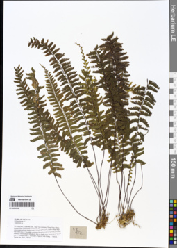
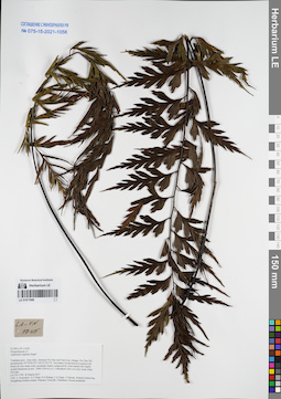
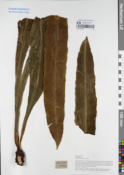
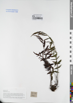
LE 01054140
Hymenasplenium cheilosorum (Mett.) Tag. det. X.C.Zhang at 05.07.2019
Additional identifications: Asplenium sp. det. Averyanov, Leonid Vladimirovich at 17.10.2018 Collectors: Averyanov, Leonid Vladimirovich; Khang Sinh Nguyen; Maisak, Tatiana Viktorovna; Truong Duc Thieu Field collecting number: VR952. Collection date: 17.10.2018. Administrative regions: VN - Tinh Ha Giang. Groups of specimens: L. V. Averyanov specimens; L. V. Averyanov herbarium; L. V. Averyanov photosOriginal label text:FLORA OF VIETNAM
Coordinates (geographic position): 23° 4′ 28.9″ N, 104° 55′ 32″ E ±1000 mComment: Polypodiaceae s.l.
Asplenium sp.
Ha Giang prov., Quan Ba distr., Tung Vai commune, Thung Pang village, around point 23º04ʹ28.9ʺN 104º55ʹ32.0ʺE, steep rocky slope to large deep cave composed with highly eroded marble-like white limestone at elevation 900–1000 m a.s.l. Secondary evergreen broad-leaved very humid forest with bamboo. Terrestrial and lithophytic fern on shady rocky stream slope. Not rare. 17 October 2018, L. Averyanov, Nguyen Sinh Khang, T. Maisak, Truong Duc Thieu, VR 952.
All photos © L. Averyanov & K.S. Nguyen
Record creation: 2019-05-03, Leonid Averyanov, PhotoScan D1Citation: Specimen LE 01054140 // Virtual herbarium of Komarov Botanical Institute RAS — http://re.herbariumle.ru/01054140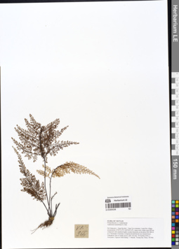
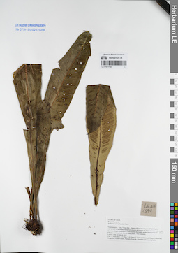
LE 01054158
Asplenium pulcherrimum (Baker) Ching det. X.C.Zhang at 05.07.2019
Additional identifications: Asplenium tenuifolium D. Don det. Averyanov, Leonid Vladimirovich at 18.10.2018 Collectors: Averyanov, Leonid Vladimirovich; Khang Sinh Nguyen; Maisak, Tatiana Viktorovna; Truong Duc Thieu Field collecting number: VR966. Collection date: 18.10.2018. Administrative regions: VN - Tinh Ha Giang. Groups of specimens: L. V. Averyanov specimens; L. V. Averyanov herbarium; L. V. Averyanov photosOriginal label text:FLORA OF VIETNAM
Coordinates (geographic position): 23° 2′ 55″ N, 104° 56′ 1.4″ E ±1000 mComment: Polypodiaceae s.l.
Aspleniaceae
Asplenium tenuifolium D. Don
Ha Giang prov., Quan Ba distr., Tung Vai commune, Lung Kho village, around point 23º02ʹ55.0ʺN 104º56ʹ01.4ʺE, steep rocky slopes near hill top composed with stratified highly eroded limestone at elevation 900–980 m a.s.l. Remnants of primary evergreen broad-leaved very humid forest. Lithophytic fern on shady mossy cliff. Not rare. 18 October 2018, L. Averyanov, Nguyen Sinh Khang, T. Maisak, Truong Duc Thieu, VR 966.
All photos © L. Averyanov & K.S. Nguyen
Record creation: 2019-05-03, Leonid Averyanov, PhotoScan D1Citation: Specimen LE 01054158 // Virtual herbarium of Komarov Botanical Institute RAS — http://re.herbariumle.ru/01054158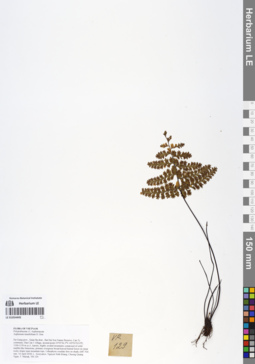
LE 01054445
Asplenium dianguiense X.C.Zhang det. X.C.Zhang at 05.07.2019
Additional identifications: Asplenium tenuifolium D. Don det. Averyanov, Leonid Vladimirovich at 14.04.2018 Collectors: Averyanov, Leonid Vladimirovich; Khang Sinh Nguyen; Chuong Quang Ngan; Maisak, Tatiana Viktorovna Field collecting number: VR129. Collection date: 14.04.2018. Administrative regions: VN - Tinh Ha Giang. Groups of specimens: L. V. Averyanov specimens; L. V. Averyanov herbarium; L. V. Averyanov photosOriginal label text:FLORA OF VIETNAM Polypodiaceae s.l. Aspleniaceae Asplenium tenuifolium D. Don Ha Giang prov., Quan Ba distr., Bat Dai Son Nature Reserve, Can Ty commune, Dau Cau 1 village, around point 23º05ʹ26.3ʺN 105º01ʹ03.0ʺE, 1100-1150 m a.s.l., karstic, highly eroded mountains composed of solid marble-like limestone, primary evergreen broad-leaved humid forest on steep rocky slopes near mountain tops. Lithophytic rosulate fern on shady cliff. Not rare. 14 April 2018, L. Averyanov, Nguyen Sinh Khang, Chuong Quang Ngan, T. Maisak, VR 129.
Comment: All photos © L. Averyanov & K.S. Nguyen
Record creation: 2019-05-03, Leonid Averyanov, PhotoScan D1Citation: Specimen LE 01054445 // Virtual herbarium of Komarov Botanical Institute RAS — http://re.herbariumle.ru/01054445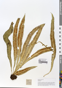
LE 01055412
Asplenium scortechinii Bedd. det. Averyanov, Leonid Vladimirovich at 07.09.2019
Additional identifications: Asplenium sp. det. Averyanov, Leonid Vladimirovich at 22.10.2018 Collectors: Averyanov, Leonid Vladimirovich; Khang Sinh Nguyen; Maisak, Tatiana Viktorovna; Truong Duc Thieu Field collecting number: VR1199. Collection date: 22.10.2018. Administrative regions: VN - Tinh Ha Giang. Groups of specimens: L. V. Averyanov specimens; L. V. Averyanov herbarium; L. V. Averyanov photosOriginal label text:FLORA OF VIETNAM.
Coordinates (geographic position): 23° 5′ 52.6″ N, 104° 51′ 26.4″ E ±1000 mComment: Polypodiaceae s.l.
Asplenium sp.
Ha Giang prov., Quan Ba distr., Cao Ma Po commune, Va Thang 1 village, around point 23º05ʹ52.6ʺN 104º51ʹ26.4ʺE, steep alluvial slopes and flattened mountain summits based on limestone at elevation 1400–1480 m a.s.l. Primary evergreen broad-leaved very humid forest. Epiphyte on mossy trees in shady place. Not common.22 October 2018, L. Averyanov, Nguyen Sinh Khang, T. Maisak, Truong Duc Thieu, VR 1199.
All photos © L. Averyanov & K.S. Nguyen
Record creation: 2019-06-11, Leonid Averyanov, PhotoScan D1Citation: Specimen LE 01055412 // Virtual herbarium of Komarov Botanical Institute RAS — http://re.herbariumle.ru/01055412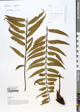
LE 01055965
Asplenium wrightii Hook. det. Averyanov, Leonid Vladimirovich at 17.07.2019
Additional identifications: Asplenium sp. det. Averyanov, Leonid Vladimirovich at 22.10.2018 Collectors: Averyanov, Leonid Vladimirovich; Nguyen Van Khang; Maisak, Tatiana Viktorovna; T.D. Thieu Field collecting number: VR1212. Collection date: 22.10.2018. Administrative regions: VN - Tinh Ha Giang. Groups of specimens: L. V. Averyanov specimens; L. V. Averyanov herbarium; L. V. Averyanov photosOriginal label text:FLORA OF VIETNAM Polypodiaceae s.l. Asplenium sp. Ha Giang prov., Quan Ba distr., Cao Ma Po commune, Va Thang 1 village, around point 23º05ʹ52.6ʺN 104º51ʹ26.4ʺE, steep alluvial slopes and flattened mountain summits based on limestone at elevation 1400–1480 m a.s.l. Primary evergreen broad-leaved very humid forest. Terrestrial fern on steep mossy shady slope. Very common. 22 October 2018, L. Averyanov, Nguyen Sinh Khang, T. Maisak, Truong Duc Thieu, VR 1212.
Coordinates (geographic position): 23° 5′ 52.6″ N, 104° 51′ 26.4″ E ±1000 mComment: All photos © L. Averyanov & K.S. Nguyen
Record creation: 2019-07-17, Leonid Averyanov, PhotoScan D1Citation: Specimen LE 01055965 // Virtual herbarium of Komarov Botanical Institute RAS — http://re.herbariumle.ru/01055965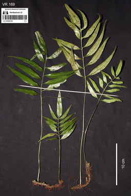
LE 01058129
Leptochilus ellipticus (Thunb.) Noot. det. Averyanov, Leonid Vladimirovich at 07.09.2019
Additional identifications: Asplenium sp. det. Averyanov, Leonid Vladimirovich at 15.04.2018 Collectors: Averyanov, Leonid Vladimirovich; Khang Sinh Nguyen; Chuong Quang Ngan; Maisak, Tatiana Viktorovna Field collecting number: VR169. Collection date: 15.04.2018. Administrative regions: VN - Tinh Ha Giang. Groups of specimens: L. V. Averyanov specimens; L. V. Averyanov photosOriginal label text:FLORA OF VIETNAM Polypodiaceae s.l. Asplenium sp. Ha Giang prov., Quan Ba distr., Bat Dai Son Nature Reserve, Can Ty commune, Lung Vay village, around point 23º05ʹ46.7ʺN 105º02ʹ53.1ʺE, 1100-1280 m a.s.l., karstic, highly eroded mountains composed of solid marble-like limestone, primary evergreen broad-leaved humid forest on steep rocky slopes near mountain tops. Creeping lithophytic or epiphytic fern in shady place. Occasional. 15 April 2018, L. Averyanov, Nguyen Sinh Khang, Chuong Quang Ngan, T. Maisak, VR 169.
Comment: All photos © L. Averyanov & K.S. Nguyen
Record creation: 2019-06-21, Аверьянов Леонид ВладимировичCitation: Specimen LE 01058129 // Virtual herbarium of Komarov Botanical Institute RAS — http://re.herbariumle.ru/01058129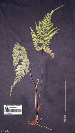
LE 01058161
Asplenium tenuifolium D.Don det. Averyanov, Leonid Vladimirovich at 16.04.2018
Collectors: Averyanov, Leonid Vladimirovich; Khang Sinh Nguyen; Chuong Quang Ngan; Maisak, Tatiana Viktorovna Field collecting number: VR289. Collection date: 16.04.2018. Administrative regions: VN - Tinh Ha Giang. Groups of specimens: L. V. Averyanov specimens; L. V. Averyanov photos; L. V. Averyanov herbariumOriginal label text:FLORA OF VIETNAM Polypodiaceae s.l. Aspleniaceae Asplenium tenuifolium D. Don Ha Giang prov., Quan Ba distr., Bat Dai Son Nature Reserve, Bat Dai Son commune, Pai Chu Phin village, around point 23º07ʹ54.9ʺN 104º59ʹ24.1ʺE, 1000-1220 m a.s.l., karstic, highly eroded mountains composed of solid marble-like limestone, primary evergreen broad-leaved and coniferous (with Pseudotsuga sinensis) humid forest on steep rocky slopes near mountain tops. Lithophyte on mossy rocks on rocky mountain top. Not common. 16 April 2018, L. Averyanov, Nguyen Sinh Khang, Chuong Quang Ngan, T. Maisak, VR 289.
Comment: All photos © L. Averyanov & K.S. Nguyen
Record creation: 2019-07-30, Аверьянов Леонид ВладимировичCitation: Specimen LE 01058161 // Virtual herbarium of Komarov Botanical Institute RAS — http://re.herbariumle.ru/01058161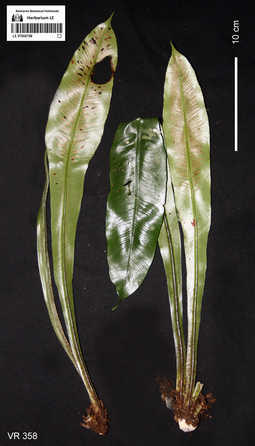
LE 01058198
Asplenium nidus L. det. Averyanov, Leonid Vladimirovich at 18.04.2018
Collectors: Averyanov, Leonid Vladimirovich; Khang Sinh Nguyen; Chuong Quang Ngan; Maisak, Tatiana Viktorovna Field collecting number: VR358. Collection date: 18.04.2018. Administrative regions: VN - Tinh Ha Giang. Groups of specimens: L. V. Averyanov specimens; L. V. Averyanov photos; L. V. Averyanov herbariumOriginal label text:FLORA OF VIETNAM Polypodiaceae s.l. Asplenium nidus L. Ha Giang prov., Quan Ba distr., Bat Dai Son Nature Reserve, Thanh Van commune, Mo Sai village, around point 23º07ʹ46.4ʺN 104º57ʹ56.2ʺE, at elevation 1000-1190 m a.s.l., karstic, highly eroded mountains composed of solid marble-like limestone, primary evergreen broad-leaved and mixed (with Pseudotsuga sinensis) humid forest on steep rocky slopes near mountain tops. Epiphyte and occasionally lithophyte on shady rocky mountain slope. Very common. 18 April 2018, L. Averyanov, Nguyen Sinh Khang, Chuong Quang Ngan, T. Maisak, VR 358.
Coordinates (geographic position): 23° 7′ 46.4″ N, 104° 57′ 56.2″ E ±1000 mComment: All photos © L. Averyanov & K.S. Nguyen
Record creation: 2019-07-30, Аверьянов Леонид ВладимировичCitation: Specimen LE 01058198 // Virtual herbarium of Komarov Botanical Institute RAS — http://re.herbariumle.ru/01058198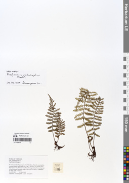
LE 01058616
Asplenium prolongatum Hook. det. Averyanov, Leonid Vladimirovich at 29.08.2019
Additional identifications: Asplenium belangeri Bory det. Averyanov, Leonid Vladimirovich at 23.10.1999 Collectors: Tien Hiep Nguyen; Phan Ke Loc; Averyanov, Leonid Vladimirovich Field collecting number: NTH3817. Collection date: 23.10.1999. Administrative regions: VN - Tinh Thai Nguyen. Groups of specimens: L. V. Averyanov specimens; L. V. Averyanov herbariumOriginal label text:FLORA OF VIETNAM Fam. Polypodiaceae s.l. Asplenium belangieri N. Vietnam, Thai Nguyen prov., Vo Nhai distr., Than Sa municipality, vicinities of Kim Son village (N 21º48' E 105º54'), 23.3 km to 18º of Thai Nguyen city. Primary broadleaved evergreen dry forest along tops of karst remnant limestone ridge at elev. 450-550 m a.s.l. Lithophyte on shady cliffs. Common. No NTH 3817 23 Oct. 1999 Collectors: N.T. Hiep, P.K. Loc, L. Averyanov.
Coordinates (geographic position): 21° 48′ N, 105° 54′ E ±1000 mRecord creation: 2019-08-29, Leonid Averyanov, PhotoScan D1Citation: Specimen LE 01058616 // Virtual herbarium of Komarov Botanical Institute RAS — http://re.herbariumle.ru/01058616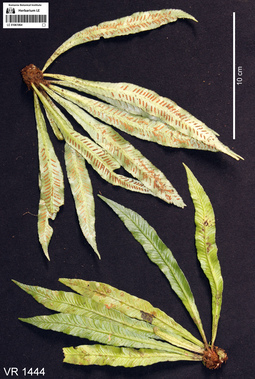
LE 01061064
Asplenium scortechinii Bedd. det. Averyanov, Leonid Vladimirovich at 10.12.2019
Collectors: Averyanov, Leonid Vladimirovich; Khang Sinh Nguyen; Maisak, Tatiana Viktorovna Field collecting number: VR1444. Collection date: 07.10.2019. Administrative regions: VN - Tinh Ha Giang. Groups of specimens: L. V. Averyanov specimens; L. V. Averyanov photosOriginal label text:FLORA OF VIETNAM
Coordinates (geographic position): 23° 3′ 12.56″ N, 104° 51′ 52.06″ E ±1000 mComment: Polypodiaceae s.l.
Asplenium scortechinii Bedd.
Ha Giang Prov., Quan Ba Distr., Tung Vai Commune, Thang Village, around point 23.05349ºN 104.86446ºE, steep rocky slopes of river valley composed with eroded limestone mixed with sandstone at elevation 1000–1100 m a.s.l. Remnants of primary evergreen broad-leaved very humid forest along river. Epiphyte on old mossy trees along stream. Common. 7 October 2019, L. Averyanov, Nguyen Sinh Khang, T. Maisak, VR 1444.
All photos © L. Averyanov & K.S. Nguyen
Record creation: 2020-01-02, Аверьянов Леонид ВладимировичCitation: Specimen LE 01061064 // Virtual herbarium of Komarov Botanical Institute RAS — http://re.herbariumle.ru/01061064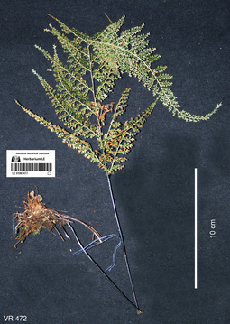
LE 01061477
Asplenium tenuifolium D.Don det. Averyanov, Leonid Vladimirovich at 19.04.2018
Collectors: Averyanov, Leonid Vladimirovich; Khang Sinh Nguyen; Chuong Quang Ngan; Maisak, Tatiana Viktorovna Field collecting number: VR472. Collection date: 19.04.2018. Administrative regions: VN - Tinh Ha Giang. Groups of specimens: L. V. Averyanov specimens; L. V. Averyanov photosOriginal label text:FLORA OF VIETNAM Polypodiaceae s.l. Aspleniaceae Asplenium tenuifolium D. Don Ha Giang prov., Quan Ba distr., Bat Dai Son Nature Reserve, Thanh Van commune, Tan village, Thong (Conifer) Mountain, around point 23º07ʹ40.3ʺN 104º57ʹ11.2ʺE, at elevation 1000-1195 m a.s.l., karstic, highly eroded mountains composed of solid marble-like limestone, primary evergreen broad-leaved and coniferous (with Pseudotsuga sinensis) humid forest on steep rocky slopes near mountain tops. Lithophyte on mossy rocks. Common. 19 April 2018, L. Averyanov, Nguyen Sinh Khang, Chuong Quang Ngan, T. Maisak, VR 472.
Coordinates (geographic position): 23° 7′ 40.3″ N, 104° 57′ 11.2″ E ±1000 mComment: All photos © L. Averyanov & K.S. Nguyen
Record creation: 2019-08-03, Аверьянов Леонид ВладимировичCitation: Specimen LE 01061477 // Virtual herbarium of Komarov Botanical Institute RAS — http://re.herbariumle.ru/01061477
LE 01062765
Asplenium scolopendrium L. det. Ivanenko, Yuri Alekseevich at 10.2020
Groups of specimens: Herbarium of Abraham EnsComment:Phyllitis 097
Record creation: 2020-08-09, Andrey Sytin, PhotoScan D2Citation: Specimen LE 01062765 // Virtual herbarium of Komarov Botanical Institute RAS — http://re.herbariumle.ru/01062765
LE 01062766
Asplenium scolopendrium L. det. Ivanenko, Yuri Alekseevich at 10.2020
Groups of specimens: Herbarium of Abraham EnsComment:Phyllitis 097
Record creation: 2020-08-09, Andrey Sytin, PhotoScan D2Citation: Specimen LE 01062766 // Virtual herbarium of Komarov Botanical Institute RAS — http://re.herbariumle.ru/01062766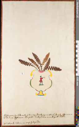
LE 01062769
Asplenium ceterach L. det. Ivanenko, Yuri Alekseevich at 10.2020
Groups of specimens: Herbarium of Abraham EnsComment:Asplenium 097
Record creation: 2020-08-09, Andrey Sytin, PhotoScan D2Citation: Specimen LE 01062769 // Virtual herbarium of Komarov Botanical Institute RAS — http://re.herbariumle.ru/01062769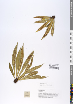
LE 01066978
Asplenium scortechinii Bedd. det. Averyanov, Leonid Vladimirovich at 10.12.2019
Collectors: Averyanov, Leonid Vladimirovich; Khang Sinh Nguyen; Maisak, Tatiana Viktorovna Field collecting number: VR1444. Collection date: 07.10.2019. Administrative regions: VN - Tinh Ha Giang. Groups of specimens: L. V. Averyanov specimens; L. V. Averyanov herbariumOriginal label text:FLORA OF VIETNAM Polypodiaceae s.l. Asplenium scortechinii Bedd. Ha Giang Prov., Quan Ba Distr., Tung Vai Commune, Thang Village, around point 23.05349ºN 104.86446ºE, steep rocky slopes of river valley composed with eroded limestone mixed with sandstone at elevation 1000–1100 m a.s.l. Remnants of primary evergreen broad-leaved very humid forest along river. Epiphyte on old mossy trees along stream. Common. 7 October 2019, L. Averyanov, Nguyen Sinh Khang, T. Maisak, VR 1444.
Coordinates (geographic position): 23° 3′ 12.56″ N, 104° 51′ 52.06″ E ±1000 mRecord creation: 2019-12-31, Leonid Averyanov, PhotoScan D1Citation: Specimen LE 01066978 // Virtual herbarium of Komarov Botanical Institute RAS — http://re.herbariumle.ru/01066978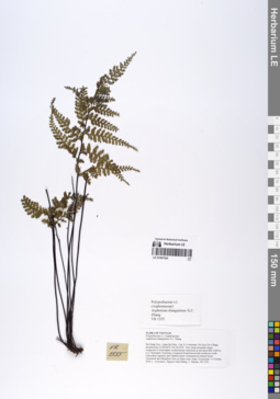
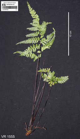
LE 01067024
Asplenium dianguiense X.C.Zhang det. Averyanov, Leonid Vladimirovich at 10.12.2019
Collectors: Averyanov, Leonid Vladimirovich; Khang Sinh Nguyen; Maisak, Tatiana Viktorovna Field collecting number: VR1555. Collection date: 11.10.2019. Administrative regions: VN - Tinh Ha Giang. Groups of specimens: L. V. Averyanov specimens; L. V. Averyanov herbariumOriginal label text:FLORA OF VIETNAM Polypodiaceae s.l. (Aspleniaceae) Asplenium dianguiense X.C. Zhang Ha Giang Prov., Quan Ba Distr., Can Ty Commune, Sin Suoi Ho Village, around point 23.09566ºN 105.02142ºE. Very steep mountain slopes composed of solid highly eroded karstic limestone at elevation 800–1000 m a.s.l. Remnants of primary evergreen broad-leaved and coniferous (with Calocedrus rupestris and Xanthocyparis vietnamensis) humid forest. Terrestrial and lithophytic fern on steep rocky slope. Occasional. 11 October 2019, L. Averyanov, Nguyen Sinh Khang, T. Maisak, VR 1555.
Coordinates (geographic position): 23° 5′ 44.38″ N, 105° 1′ 17.11″ E ±1000 mRecord creation: 2019-12-31, Leonid Averyanov, PhotoScan D1Citation: Specimen LE 01067024 // Virtual herbarium of Komarov Botanical Institute RAS — http://re.herbariumle.ru/01067024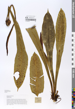
LE 01067035
Asplenium nidus L. det. Averyanov, Leonid Vladimirovich at 10.12.2019
Collectors: Averyanov, Leonid Vladimirovich; Khang Sinh Nguyen; Maisak, Tatiana Viktorovna; Chuong Quang Ngan Field collecting number: VR358. Collection date: 18.04.2018. Administrative regions: VN - Tinh Ha Giang. Groups of specimens: L. V. Averyanov specimens; L. V. Averyanov photos; L. V. Averyanov herbariumOriginal label text:FLORA OF VIETNAM Polypodiaceae s.l. Asplenium nidus L. Ha Giang prov., Quan Ba distr., Bat Dai Son Nature Reserve, Thanh Van commune, Mo Sai village, around point 23º07ʹ46.4ʺN 104º57ʹ56.2ʺE, at elevation 1000-1190 m a.s.l., karstic, highly eroded mountains composed of solid marble-like limestone, primary evergreen broad-leaved and mixed (with Pseudotsuga sinensis) humid forest on steep rocky slopes near mountain tops. Epiphyte and occasionally lithophyte on shady rocky mountain slope. Very common. 18 April 2018, L. Averyanov, Nguyen Sinh Khang, Chuong Quang Ngan, T. Maisak, VR 358 (HN, LE01058198).
Coordinates (geographic position): 23° 7′ 46.4″ N, 104° 57′ 56.2″ E ±1000 mComment: All photos © L. Averyanov & K.S. Nguyen
Record creation: 2020-01-05, Leonid Averyanov, PhotoScan D1Citation: Specimen LE 01067035 // Virtual herbarium of Komarov Botanical Institute RAS — http://re.herbariumle.ru/01067035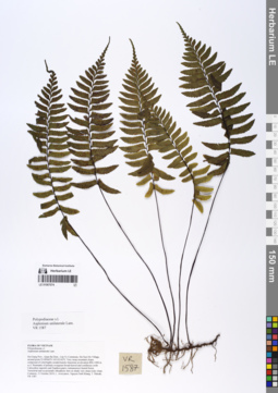
LE 01067074
Hymenasplenium unilaterale (Lam.) Hayata det. Averyanov, Leonid Vladimirovich at 19.02.2020
Additional identifications: Asplenium unilaterale Lam. det. Averyanov, Leonid Vladimirovich at 10.12.2019 Collectors: Averyanov, Leonid Vladimirovich; Khang Sinh Nguyen; Maisak, Tatiana Viktorovna Field collecting number: VR1587. Collection date: 11.10.2019. Administrative regions: VN - Tinh Ha Giang. Groups of specimens: L. V. Averyanov specimens; L. V. Averyanov herbariumOriginal label text:FLORA OF VIETNAM Polypodiaceae s.l. Asplenium unilaterale Lam. Ha Giang Prov., Quan Ba Distr., Can Ty Commune, Sin Suoi Ho Village, around point 23.09566ºN 105.02142ºE. Very steep mountain slopes composed of solid highly eroded karstic limestone at elevation 800–1000 m a.s.l. Remnants of primary evergreen broad-leaved and coniferous (with Calocedrus rupestris and Xanthocyparis vietnamensis) humid forest. Terrestrial and occasionally lithophytic fern on shady very steep rocky slope. Common. 11 October 2019, L. Averyanov, Nguyen Sinh Khang, T. Maisak, VR 1587.
Coordinates (geographic position): 23° 5′ 44.38″ N, 105° 1′ 17.11″ E ±1000 mRecord creation: 2019-12-31, Leonid Averyanov, PhotoScan D1Citation: Specimen LE 01067074 // Virtual herbarium of Komarov Botanical Institute RAS — http://re.herbariumle.ru/01067074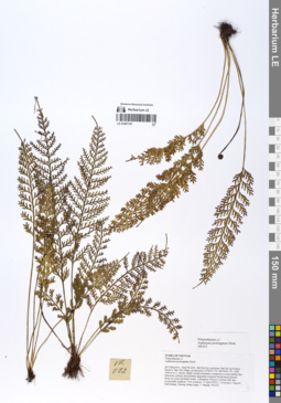
LE 01067147
Asplenium prolongatum Hook. det. Averyanov, Leonid Vladimirovich at 10.12.2019
Collectors: Averyanov, Leonid Vladimirovich; Khang Sinh Nguyen; Maisak, Tatiana Viktorovna; Chuong Quang Ngan Field collecting number: VR072. Collection date: 13.04.2018. Administrative regions: VN - Tinh Ha Giang. Groups of specimens: L. V. Averyanov specimens; L. V. Averyanov herbariumOriginal label text:FLORA OF VIETNAM Polypodiaceae s.l. Asplenium prolongatum Hook. Ha Giang prov., Quan Ba distr., Bat Dai Son commune, Bat Dai Son Nature Reserve, San Chu village, around point 23º08ʹ55.1ʺN 104º59ʹ45.7ʺE, 1000-1200 m a.s.l., karstic, highly eroded mountains composed of solid marble-like limestone, primary and partially degraded evergreen broad-leaved humid forest on rocky mountain slopes. Lithophyte of mossy vertical cliff, also occasionally epiphyte. Very common. 13 April 2018, L. Averyanov, Nguyen Sinh Khang, Chuong Quang Ngan, T. Maisak, VR 072 (HN, LE01085103 – photo).
Comment: All photos © L. Averyanov & K.S. Nguyen
Record creation: 2020-01-05, Leonid Averyanov, PhotoScan D1Citation: Specimen LE 01067147 // Virtual herbarium of Komarov Botanical Institute RAS — http://re.herbariumle.ru/01067147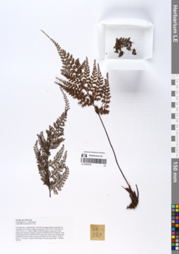
LE 01067278
Asplenium tenuifolium D.Don det. Averyanov, Leonid Vladimirovich at 10.12.2019
Collectors: Averyanov, Leonid Vladimirovich; Khang Sinh Nguyen; Maisak, Tatiana Viktorovna; Chuong Quang Ngan Field collecting number: VR289. Collection date: 16.04.2019. Administrative regions: VN - Tinh Ha Giang. Groups of specimens: L. V. Averyanov specimens; L. V. Averyanov herbariumOriginal label text:FLORA OF VIETNAM Polypodiaceae s.l. Aspleniaceae Asplenium tenuifolium D. Don Ha Giang prov., Quan Ba distr., Bat Dai Son Nature Reserve, Bat Dai Son commune, Pai Chu Phin village, around point 23º07ʹ54.9ʺN 104º59ʹ24.1ʺE, 1000-1220 m a.s.l., karstic, highly eroded mountains composed of solid marble-like limestone, primary evergreen broad-leaved and coniferous (with Pseudotsuga sinensis) humid forest on steep rocky slopes near mountain tops. Lithophyte on mossy rocks on rocky mountain top. Not common. 16 April 2018, L. Averyanov, Nguyen Sinh Khang, Chuong Quang Ngan, T. Maisak, VR 289 (HN, LE01058161 – photo).
Comment: All photos © L. Averyanov & K.S. Nguyen
Record creation: 2020-01-05, Leonid Averyanov, PhotoScan D1Citation: Specimen LE 01067278 // Virtual herbarium of Komarov Botanical Institute RAS — http://re.herbariumle.ru/01067278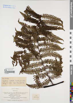
LE 01068289
Cyathea salletii Tardieu & C.Chr. ex C.Chr. & Tardieu det. Phan Ke Loc at 22.07.1995
Collectors: Averyanov, Leonid Vladimirovich; N.Q. Binh; Phan Ke Loc Field collecting number: VH2547. Collection date: 11.03.1997. Administrative regions: VN - Tinh Lam GJong. Groups of specimens: L. V. Averyanov specimens; L. V. Averyanov herbarium; Соглашение Минобрнауки №075-15-2021-1056Original label text:FLORA OF VIETNAM
Asplenium wrightii Eaton
S. Vietnam, Prov. Lam Dong, 14 km to NNW from Dalat city (N 12° 05′, E 108° 22′). Primary closed mixed forest with Pinus kesiya and P.
krempfii at 1740-1760 m alt.
Epiphytic and epilitic fern. Common.
VH 2547 11.03.1997
International Botanical Expedition of the U.S.A. National Geographic
Society (grant No 5803-96)
Collectors: L. Averyanov, N.Q. Binh, N.V. Duy, P.K. Loc
Coordinates (geographic position): 12° 5′ N, 108° 22′ E ±1000 mRecord creation: 2022-01-18, Galina Savich, PhotoScan D2Citation: Specimen LE 01068289 // Virtual herbarium of Komarov Botanical Institute RAS — http://re.herbariumle.ru/01068289Asplenium wrightii Eaton
S. Vietnam, Prov. Lam Dong, 14 km to NNW from Dalat city (N 12° 05′, E 108° 22′). Primary closed mixed forest with Pinus kesiya and P.
krempfii at 1740-1760 m alt.
Epiphytic and epilitic fern. Common.
VH 2547 11.03.1997
International Botanical Expedition of the U.S.A. National Geographic
Society (grant No 5803-96)
Collectors: L. Averyanov, N.Q. Binh, N.V. Duy, P.K. Loc
LE 01070143
Asplenium dianguiense X.C.Zhang det. X.C.Zhang at 2019
Collectors: Averyanov, Leonid Vladimirovich; Khang Sinh Nguyen; Maisak, Tatiana Viktorovna Field collecting number: VR1555. Collection date: 11.10.2019. Administrative regions: VN - Tinh Ha Giang. Groups of specimens: L. V. Averyanov specimens; L. V. Averyanov photosOriginal label text:FLORA OF VIETNAM
Coordinates (geographic position): 23° 5′ 44.38″ N, 105° 1′ 17.11″ E ±1000 mComment: Polypodiaceae s.l. (Aspleniaceae)
Asplenium dianguiense X.C. Zhang
Ha Giang Prov., Quan Ba Distr., Can Ty Commune, Sin Suoi Ho Village, around point 23.09566ºN 105.02142ºE. Very steep mountain slopes composed of solid highly eroded karstic limestone at elevation 800–1000 m a.s.l. Remnants of primary evergreen broad-leaved and coniferous (with Calocedrus rupestris and Xanthocyparis vietnamensis) humid forest. Terrestrial and lithophytic fern on steep rocky slope. Occasional. 11 October 2019, L. Averyanov, Nguyen Sinh Khang, T. Maisak, VR 1555.
All photos © L. Averyanov & K.S. Nguyen
Record creation: 2020-01-04, Аверьянов Леонид ВладимировичCitation: Specimen LE 01070143 // Virtual herbarium of Komarov Botanical Institute RAS — http://re.herbariumle.ru/01070143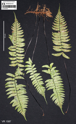
LE 01070190
Asplenium unilaterale Lam. det. Averyanov, Leonid Vladimirovich at 10.12.2019
Additional identifications: Hymenasplenium unilaterale (Lam.) Hayata det. Averyanov, Leonid Vladimirovich at 19.02.2020 Collectors: Averyanov, Leonid Vladimirovich; Khang Sinh Nguyen; Maisak, Tatiana Viktorovna Field collecting number: VR1587. Collection date: 11.10.2019. Administrative regions: VN - Tinh Ha Giang. Groups of specimens: L. V. Averyanov specimens; L. V. Averyanov photosOriginal label text:FLORA OF VIETNAM
Coordinates (geographic position): 23° 5′ 44.38″ N, 105° 1′ 17.11″ E ±1000 mComment: Polypodiaceae s.l.
Asplenium unilaterale Lam.
Ha Giang Prov., Quan Ba Distr., Can Ty Commune, Sin Suoi Ho Village, around point 23.09566ºN 105.02142ºE. Very steep mountain slopes composed of solid highly eroded karstic limestone at elevation 800–1000 m a.s.l. Remnants of primary evergreen broad-leaved and coniferous (with Calocedrus rupestris and Xanthocyparis vietnamensis) humid forest. Terrestrial and occasionally lithophytic fern on shady very steep rocky slope. Common. 11 October 2019, L. Averyanov, Nguyen Sinh Khang, T. Maisak, VR 1587.
All photos © L. Averyanov & K.S. Nguyen
Record creation: 2020-01-04, Аверьянов Леонид ВладимировичCitation: Specimen LE 01070190 // Virtual herbarium of Komarov Botanical Institute RAS — http://re.herbariumle.ru/01070190
LE 01073586
Additional identifications: Asplenium holosorum Christ det. Nuraliev, M. S.; Asplenium ensiforme Wall. det. Cheng-Wei Chen Collectors: Nuraliev, M. S. Field collecting number: NUR 100m. Collection date: 16.06.2009. Administrative regions: VN - Tinh Lao Cai. Original label text: Comment:
Asplenium holosorum Christ
Syn. of Asplenium ensiforme Wall.
Det. Cheng-Wei Chen
photo
NORTHERN VIETNAM
Lao Cai Prov., Sa Pa Distr., San Sa Ho municip.,
Hoang Lien National Park, Tram Ton area
Forest
Nuraliev M.S. NUR 100m 16.06.2009
All photos © M. Nuraliev
Record creation: 2020-09-04, Nuraliev MaximCitation: Specimen LE 01073586 // Virtual herbarium of Komarov Botanical Institute RAS — http://re.herbariumle.ru/01073586
LE 01073587
Asplenium ensiforme Wall.
Collectors: Nuraliev, M. S. Field collecting number: NUR 118a. Collection date: 24.06.2009. Administrative regions: VN - Tinh Lao Cai. Original label text:Asplenium ensiforme Wall.
photo
NORTHERN VIETNAM
Lao Cai Prov., Sa Pa Distr., San Sa Ho municip.,
Hoang Lien National Park, Tram Ton area
Forest, near a trail
N 22° 21' 00'' E 103° 46' 45'' elev. 2030 m
Nuraliev M.S. NUR 118a 24.06.2009
All photos © M. Nuraliev
Record creation: 2020-09-04, Nuraliev MaximCitation: Specimen LE 01073587 // Virtual herbarium of Komarov Botanical Institute RAS — http://re.herbariumle.ru/01073587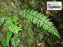
LE 01073588
Asplenium yoshinagae ssp. indicum (Sledge) Fraser-Jenk. det. Cheng-Wei Chen
Collectors: Nuraliev, M. S. Field collecting number: NUR 100n. Collection date: 30.06.2009. Administrative regions: VN - Tinh Lao Cai. Original label text:Asplenium yoshinagae ssp. indicum (Sledge) Fraser-Jenk.
Det. Cheng-Wei Chen
photo
NORTHERN VIETNAM
Lao Cai Prov., Sa Pa Distr., San Sa Ho municip.,
Hoang Lien National Park, Tram Ton area
Forest
Nuraliev M.S. NUR 100n 30.06.2009
All photos © M. Nuraliev
Record creation: 2020-09-04, Nuraliev MaximCitation: Specimen LE 01073588 // Virtual herbarium of Komarov Botanical Institute RAS — http://re.herbariumle.ru/01073588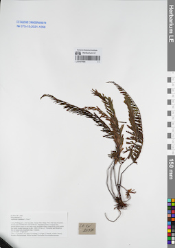
LE 01077684
Asplenium caudatum G.Forst. ⟮prelim. ID⟯ det. Averyanov, Leonid Vladimirovich at 04.04.2017
Collectors: Averyanov, Leonid Vladimirovich; Tien Hiep Nguyen; Khang Sinh Nguyen; et al. Field collecting number: LA-VN2057. Collection date: 04.04.2017. Administrative regions: LA - Luang Prabang Province. Groups of specimens: L. V. Averyanov specimens; L. V. Averyanov herbarium; Соглашение Минобрнауки №075-15-2021-1056Original label text:FLORA OF LAOS
Polypodiaceae s.l.
Asplenium caudatum G. Forst.?
Luang Prabang prov., Pon Xay distr., Houay Man village, Phou Pak Sang Mountain, around point 19°59′03.8′'N 102°25′09.0′'E.
Degraded primary evergreen and semideciduous forest on very steep rocky mountain slopes composed by solid marble like highly eroded limestone at elev. 1000-1150 m a.s.l. Terrestrial and lithophytic fern on steep rocky mountain slope. Common.
LA-VN 2057 4 April 2017
Coll.: L.Averyanov, N.T.Hiep, N.S.Khang, C.Q.Ngan, T.Maisak, Vichith Lamxay, Koudkeo Phommachanh, Phizar Sayalath, Keooudone Souvannakhoummane.
Coordinates (geographic position): 19° 59′ 3.8″ N, 102° 25′ 9″ E ±1000 mRecord creation: 2021-12-02, Tatiana Maisak, PhotoScan D2Citation: Specimen LE 01077684 // Virtual herbarium of Komarov Botanical Institute RAS — http://re.herbariumle.ru/01077684Polypodiaceae s.l.
Asplenium caudatum G. Forst.?
Luang Prabang prov., Pon Xay distr., Houay Man village, Phou Pak Sang Mountain, around point 19°59′03.8′'N 102°25′09.0′'E.
Degraded primary evergreen and semideciduous forest on very steep rocky mountain slopes composed by solid marble like highly eroded limestone at elev. 1000-1150 m a.s.l. Terrestrial and lithophytic fern on steep rocky mountain slope. Common.
LA-VN 2057 4 April 2017
Coll.: L.Averyanov, N.T.Hiep, N.S.Khang, C.Q.Ngan, T.Maisak, Vichith Lamxay, Koudkeo Phommachanh, Phizar Sayalath, Keooudone Souvannakhoummane.
LE 01077685
Asplenium rupestre Hope ⟮prelim. ID⟯ det. Averyanov, Leonid Vladimirovich at 05.04.2017
Collectors: Averyanov, Leonid Vladimirovich; Tien Hiep Nguyen; Khang Sinh Nguyen; et al. Field collecting number: LA-VN2092. Collection date: 05.04.2017. Administrative regions: LA - Luang Prabang Province. Groups of specimens: L. V. Averyanov specimens; L. V. Averyanov herbarium; Соглашение Минобрнауки №075-15-2021-1056Original label text:FLORA OF LAOS
Polypodiaceae s.l.
Asplenium rupestre Hope?
Luang Prabang prov., Pon Xay distr., between Houay Man and Nam Bo villages, Phou Hua Ben Toc Mountain, around point 19°57′33.1′'N 102°25′25.8′'E. Degraded primary evergreen and semideciduous forest on very steep rocky mountain slopes composed by solid marble like highly eroded limestone at elev. 500-650 m a.s.l.
Terrestrial and lithophytic fern in shady rocky place near mountain top. Not rare.LA-VN 2092 5 April 2017
Coll.: L.Averyanov, N.T.Hiep, N.S.Khang, C.Q.Ngan, T.Maisak, Vichith Lamxay, Koudkeo Phommachanh, Phizar Sayalath, Keooudone Souvannakhoummane.
Coordinates (geographic position): 19° 57′ 33.1″ N, 102° 25′ 25.8″ E ±1000 mRecord creation: 2021-12-02, Tatiana Maisak, PhotoScan D2. Processing status: work_status_1Citation: Specimen LE 01077685 // Virtual herbarium of Komarov Botanical Institute RAS — http://re.herbariumle.ru/01077685Polypodiaceae s.l.
Asplenium rupestre Hope?
Luang Prabang prov., Pon Xay distr., between Houay Man and Nam Bo villages, Phou Hua Ben Toc Mountain, around point 19°57′33.1′'N 102°25′25.8′'E. Degraded primary evergreen and semideciduous forest on very steep rocky mountain slopes composed by solid marble like highly eroded limestone at elev. 500-650 m a.s.l.
Terrestrial and lithophytic fern in shady rocky place near mountain top. Not rare.LA-VN 2092 5 April 2017
Coll.: L.Averyanov, N.T.Hiep, N.S.Khang, C.Q.Ngan, T.Maisak, Vichith Lamxay, Koudkeo Phommachanh, Phizar Sayalath, Keooudone Souvannakhoummane.
LE 01077688
Asplenium rupestre Hope ⟮prelim. ID⟯ det. Averyanov, Leonid Vladimirovich at 26.03.2017
Collectors: Averyanov, Leonid Vladimirovich; Tien Hiep Nguyen; Khang Sinh Nguyen; et al. Field collecting number: LA-VN1745. Collection date: 26.03.2017. Administrative regions: LA - Vientiane Province. Groups of specimens: L. V. Averyanov specimens; L. V. Averyanov herbarium; Соглашение Минобрнауки №075-15-2021-1056Original label text:FLORA OF LAOS
Polypodiaceae s.l.
Asplenium rupestre Hope?
Vientiane prov., Kasi distr., between Pa Chao and Nam Ken villages, Pa Chao Mt., around point 19°19′50.6′'N 102°21′20.5′'E.Secondary broad-leaved evergreen dry forest on very steep rocky mountain slopes composed by solid marble like highly eroded limestone at elev. 1000-1100 m a.s.l. Lithophytic fern on rocky steep slope. Not rare. LA-VN 1745 26 March 2017
Coll.: L.Averyanov, N.T.Hiep, N.S.Khang, C.Q.Ngan, T.Maisak, Khamla Inkhavilay, Hongthong Southyvohanh, Pinmany Sisavath, Chanthala Cheuaysamphanh.
Coordinates (geographic position): 19° 19′ 50.6″ N, 102° 21′ 20.5″ E ±1000 mRecord creation: 2021-12-02, Tatiana Maisak, PhotoScan D2. Processing status: work_status_1Citation: Specimen LE 01077688 // Virtual herbarium of Komarov Botanical Institute RAS — http://re.herbariumle.ru/01077688Polypodiaceae s.l.
Asplenium rupestre Hope?
Vientiane prov., Kasi distr., between Pa Chao and Nam Ken villages, Pa Chao Mt., around point 19°19′50.6′'N 102°21′20.5′'E.Secondary broad-leaved evergreen dry forest on very steep rocky mountain slopes composed by solid marble like highly eroded limestone at elev. 1000-1100 m a.s.l. Lithophytic fern on rocky steep slope. Not rare. LA-VN 1745 26 March 2017
Coll.: L.Averyanov, N.T.Hiep, N.S.Khang, C.Q.Ngan, T.Maisak, Khamla Inkhavilay, Hongthong Southyvohanh, Pinmany Sisavath, Chanthala Cheuaysamphanh.
LE 01077689
Asplenium antrophyoides Christ det. Averyanov, Leonid Vladimirovich at 05.04.2017
Collectors: Averyanov, Leonid Vladimirovich; Tien Hiep Nguyen; Khang Sinh Nguyen; et al. Field collecting number: LA-VN2104. Collection date: 05.04.2017. Administrative regions: LA - Luang Prabang Province. Groups of specimens: L. V. Averyanov specimens; L. V. Averyanov herbarium; Соглашение Минобрнауки №075-15-2021-1056Original label text:FLORA OF LAOS
Polypodiaceae s.l.
Asplenium antrophyoides Christ
Luang Prabang prov., Pon Xay distr., between Houay Man and Nam Bo villages, Phou Hua Ben Toc Mountain, around point 19°57′33.1′'N 102°25′25.8′'E.
Degraded primary evergreen and semideciduous forest on very steep rocky mountain slopes composed by solid marble like highly eroded limestone at elev. 500-650 m a.s.l.
Rosulate lthophytic ferb on shady cliffs near mountain top. Very common.
LA-VN 2104 5 April 2017
Coll.: L.Averyanov, N.T.Hiep, N.S.Khang, C.Q.Ngan, T.Maisak, Vichith Lamxay, Koudkeo Phommachanh, Phizar Sayalath, Keooudone Souvannakhoummane.
Coordinates (geographic position): 19° 57′ 33.1″ N, 102° 25′ 25.8″ E ±1000 mRecord creation: 2021-12-02, Tatiana Maisak, PhotoScan D2Citation: Specimen LE 01077689 // Virtual herbarium of Komarov Botanical Institute RAS — http://re.herbariumle.ru/01077689Polypodiaceae s.l.
Asplenium antrophyoides Christ
Luang Prabang prov., Pon Xay distr., between Houay Man and Nam Bo villages, Phou Hua Ben Toc Mountain, around point 19°57′33.1′'N 102°25′25.8′'E.
Degraded primary evergreen and semideciduous forest on very steep rocky mountain slopes composed by solid marble like highly eroded limestone at elev. 500-650 m a.s.l.
Rosulate lthophytic ferb on shady cliffs near mountain top. Very common.
LA-VN 2104 5 April 2017
Coll.: L.Averyanov, N.T.Hiep, N.S.Khang, C.Q.Ngan, T.Maisak, Vichith Lamxay, Koudkeo Phommachanh, Phizar Sayalath, Keooudone Souvannakhoummane.
LE 01077691
Asplenium caudatum G.Forst. ⟮prelim. ID⟯ det. Averyanov, Leonid Vladimirovich at 31.03.2017
Collectors: Averyanov, Leonid Vladimirovich; Tien Hiep Nguyen; Khang Sinh Nguyen; et al. Field collecting number: LA-VN1893. Collection date: 31.03.2017. Administrative regions: LA - Luang Prabang Province. Groups of specimens: L. V. Averyanov specimens; L. V. Averyanov herbarium; Соглашение Минобрнауки №075-15-2021-1056Original label text:FLORA OF LAOS
Polypodiaceae
Asplenium caudatum G.Forst.?
Luang Prabang prov., Ngoy distr., Nong Khiew village, Pha Deng Mountain around point 20°34′14.3′'N 102°37′31.8′'E.
Secondary semideciduous and evergreen dry forest on very steep rocky mountain slopes composed by solid marble like highly eroded limestone at elev. 700-825 m a.s.l.
Terrestrial and lithophytic fern on mossy mountain top. Common.
LA-VN 1893 31 March 2017
Coll.: L.Averyanov, N.T.Hiep, N.S.Khang, C.Q.Ngan, T.Maisak, Vichith Lamxay, Koudkeo Phommachanh, Phizar Sayalath, Keooudone Souvannakhoummane.
Coordinates (geographic position): 20° 34′ 14.3″ N, 102° 37′ 31.8″ E ±1000 mRecord creation: 2021-12-02, Tatiana Maisak, PhotoScan D2Citation: Specimen LE 01077691 // Virtual herbarium of Komarov Botanical Institute RAS — http://re.herbariumle.ru/01077691Polypodiaceae
Asplenium caudatum G.Forst.?
Luang Prabang prov., Ngoy distr., Nong Khiew village, Pha Deng Mountain around point 20°34′14.3′'N 102°37′31.8′'E.
Secondary semideciduous and evergreen dry forest on very steep rocky mountain slopes composed by solid marble like highly eroded limestone at elev. 700-825 m a.s.l.
Terrestrial and lithophytic fern on mossy mountain top. Common.
LA-VN 1893 31 March 2017
Coll.: L.Averyanov, N.T.Hiep, N.S.Khang, C.Q.Ngan, T.Maisak, Vichith Lamxay, Koudkeo Phommachanh, Phizar Sayalath, Keooudone Souvannakhoummane.
LE 01077693
Asplenium rupestre Hope ⟮prelim. ID⟯ det. Averyanov, Leonid Vladimirovich at 05.04.2017
Collectors: Averyanov, Leonid Vladimirovich; Tien Hiep Nguyen; Khang Sinh Nguyen; et al. Field collecting number: LA-VN2129. Collection date: 05.04.2017. Administrative regions: LA - Luang Prabang Province. Groups of specimens: L. V. Averyanov specimens; L. V. Averyanov herbarium; Соглашение Минобрнауки №075-15-2021-1056Original label text:FLORA OF LAOS
Polypodiaceae s.l.
Coordinates (geographic position): 19° 57′ 33.1″ N, 102° 25′ 25.8″ E ±1000 mRecord creation: 2021-12-02, Tatiana Maisak, PhotoScan D2Citation: Specimen LE 01077693 // Virtual herbarium of Komarov Botanical Institute RAS — http://re.herbariumle.ru/01077693Polypodiaceae s.l.
Asplenium rupestre Hope?
Luang Prabang prov., Pon Xay distr., between Houay Man and Nam Bo villages, Phou Hua Ben Toc Mountain, around point 19°57′33.1′'N 102°25′25.8′'E.
Degraded primary evergreen and semideciduous forest on very steep rocky mountain slopes composed by solid marble like highly eroded limestone at elev. 500-650 m a.s.l.
Lithophytic fern on rocky steep slope. Not rare.
LA-VN 2129 5 April 2017
Coll.: L.Averyanov, N.T.Hiep, N.S.Khang, C.Q.Ngan, T.Maisak, Vichith Lamxay, Koudkeo Phommachanh, Phizar Sayalath, Keooudone Souvannakhoummane.
LE 01077694
Asplenium antrophyoides Christ det. Averyanov, Leonid Vladimirovich at 05.04.2017
Collectors: Averyanov, Leonid Vladimirovich; Tien Hiep Nguyen; Khang Sinh Nguyen; et al. Field collecting number: LA-VN2131. Collection date: 05.04.2017. Administrative regions: LA - Luang Prabang Province. Groups of specimens: L. V. Averyanov specimens; L. V. Averyanov herbarium; Соглашение Минобрнауки №075-15-2021-1056Original label text:FLORA OF LAOS
Polypodiaceae s.l.
Asplenium antrophyoides Christ
Luang Prabang prov., Pon Xay distr., between Houay Man and Nam Bo villages, Phou Hua Ben Toc Mountain, around point 19°57′33.1′'N 102°25′25.8′'E.
Degraded primary evergreen and semideciduous forest on very steep rocky mountain slopes composed by solid marble like highly eroded limestone at elev. 500-650 m a.s.l.
Lithophytic fern in shady rocky slope near mountain top. Common.
LA-VN 2131 5 April 2017
Coll.: L.Averyanov, N.T.Hiep, N.S.Khang, C.Q.Ngan, T.Maisak, Vichith Lamxay, Koudkeo Phommachanh, Phizar Sayalath, Keooudone Souvannakhoummane.
Coordinates (geographic position): 19° 57′ 33.1″ N, 102° 25′ 25.8″ E ±1000 mRecord creation: 2021-12-02, Tatiana Maisak, PhotoScan D2Citation: Specimen LE 01077694 // Virtual herbarium of Komarov Botanical Institute RAS — http://re.herbariumle.ru/01077694Polypodiaceae s.l.
Asplenium antrophyoides Christ
Luang Prabang prov., Pon Xay distr., between Houay Man and Nam Bo villages, Phou Hua Ben Toc Mountain, around point 19°57′33.1′'N 102°25′25.8′'E.
Degraded primary evergreen and semideciduous forest on very steep rocky mountain slopes composed by solid marble like highly eroded limestone at elev. 500-650 m a.s.l.
Lithophytic fern in shady rocky slope near mountain top. Common.
LA-VN 2131 5 April 2017
Coll.: L.Averyanov, N.T.Hiep, N.S.Khang, C.Q.Ngan, T.Maisak, Vichith Lamxay, Koudkeo Phommachanh, Phizar Sayalath, Keooudone Souvannakhoummane.
LE 01077695
Asplenium caudatum G.Forst. ⟮prelim. ID⟯ det. Averyanov, Leonid Vladimirovich at 05.04.2017
Collectors: Averyanov, Leonid Vladimirovich; Tien Hiep Nguyen; Khang Sinh Nguyen; et al. Field collecting number: LA-VN2138. Collection date: 05.04.2017. Administrative regions: LA - Luang Prabang Province. Groups of specimens: L. V. Averyanov specimens; L. V. Averyanov herbarium; Соглашение Минобрнауки №075-15-2021-1056Original label text:FLORA OF LAOS
Polypodiaceae s.l.
Asplenium caudatum G. Forst.?
Luang Prabang prov., Pon Xay distr., along the way to Bane Phou Souong village, Pha Hiua Bin Toc Mountain, around point 19°57′37.0′'N 102°25′03.0′'E.
Degraded primary evergreen and semideciduous forest on very steep rocky mountain slopes composed by solid marble like highly eroded limestone at elev. 600-850 m a.s.l.
Terrestrial and lithophytic fern on steep rocky mountain slope. Very common.
LA-VN 2138 5 April 2017
Coll.: L.Averyanov, N.T.Hiep, N.S.Khang, C.Q.Ngan, T.Maisak, Vichith Lamxay, Koudkeo Phommachanh, Phizar Sayalath, Keooudone Souvannakhoummane.
Coordinates (geographic position): 19° 57′ 37″ N, 102° 25′ 3″ E ±1000 mRecord creation: 2021-12-02, Tatiana Maisak, PhotoScan D2Citation: Specimen LE 01077695 // Virtual herbarium of Komarov Botanical Institute RAS — http://re.herbariumle.ru/01077695Polypodiaceae s.l.
Asplenium caudatum G. Forst.?
Luang Prabang prov., Pon Xay distr., along the way to Bane Phou Souong village, Pha Hiua Bin Toc Mountain, around point 19°57′37.0′'N 102°25′03.0′'E.
Degraded primary evergreen and semideciduous forest on very steep rocky mountain slopes composed by solid marble like highly eroded limestone at elev. 600-850 m a.s.l.
Terrestrial and lithophytic fern on steep rocky mountain slope. Very common.
LA-VN 2138 5 April 2017
Coll.: L.Averyanov, N.T.Hiep, N.S.Khang, C.Q.Ngan, T.Maisak, Vichith Lamxay, Koudkeo Phommachanh, Phizar Sayalath, Keooudone Souvannakhoummane.
LE 01077700
Asplenium antrophyoides Christ det. Averyanov, Leonid Vladimirovich at 27.03.2017
Collectors: Averyanov, Leonid Vladimirovich; Tien Hiep Nguyen; Khang Sinh Nguyen; et al. Field collecting number: LA-VN1756. Collection date: 27.03.2017. Administrative regions: LA - Vientiane Province. Groups of specimens: L. V. Averyanov specimens; L. V. Averyanov herbarium; Соглашение Минобрнауки №075-15-2021-1056Original label text:FLORA OF LAOS
Polypodiaceae s.l.
Asplenium antrophyoides Christ
Vientiane prov., Kasi distr., between Pa Chao and Nam Ken villages, Pa Chao Mt., around point 19°19′35.5′'N 102°22′57.7′'E.
Secondary broad-leaved evergreen dry forest on very steep rocky mountain slopes composed by solid marble like highly eroded limestone at elev. 1100-1200 m a.s.l.
Lithophytic and epiphytic fern on rather open steep rocky slope. Common.
LA-VN 1756 27 March 2017
Coll.: L.Averyanov, N.T.Hiep, N.S.Khang, C.Q.Ngan, T.Maisak, Khamla Inkhavilay, Hongthong Southyvohanh, Pinmany Sisavath, Chanthala Cheuaysamphanh.
LE 01077701
Asplenium rupestre Hope ⟮prelim. ID⟯ det. Averyanov, Leonid Vladimirovich at 28.03.2017
Collectors: Averyanov, Leonid Vladimirovich; Tien Hiep Nguyen; Khang Sinh Nguyen; et al. Field collecting number: LA-VN1944. Collection date: 28.03.2017. Administrative regions: LA - Vientiane Province. Groups of specimens: L. V. Averyanov specimens; L. V. Averyanov herbarium; Соглашение Минобрнауки №075-15-2021-1056Original label text:FLORA OF LAOS
Polypodiaceae s.l.
Asplenium rupestre Hope?
Vientiane prov., Kasi distr., Si Sang Vone village, around point 19°06′10.9′'N 102°10′46.1′'E.
Secondary and primary evergreen dry forest on very steep rocky mountain slopes composed by solid marble like highly eroded limestone at elev. 600-750 m a.s.l.
Lithophytic fern on shady rocky slope near mountain top. Not rare.
LA-VN 1841 28 March 2017
Coll.: L.Averyanov, N.T.Hiep, N.S.Khang, C.Q.Ngan, T.Maisak, Khamla Inkhavilay, Hongthong Southyvohanh, Pinmany Sisavath, Chanthala Cheuaysamphanh.
Coordinates (geographic position): 19° 6′ 10.9″ N, 102° 10′ 46.1″ E ±1000 mRecord creation: 2021-12-02, Tatiana Maisak, PhotoScan D2Citation: Specimen LE 01077701 // Virtual herbarium of Komarov Botanical Institute RAS — http://re.herbariumle.ru/01077701Polypodiaceae s.l.
Asplenium rupestre Hope?
Vientiane prov., Kasi distr., Si Sang Vone village, around point 19°06′10.9′'N 102°10′46.1′'E.
Secondary and primary evergreen dry forest on very steep rocky mountain slopes composed by solid marble like highly eroded limestone at elev. 600-750 m a.s.l.
Lithophytic fern on shady rocky slope near mountain top. Not rare.
LA-VN 1841 28 March 2017
Coll.: L.Averyanov, N.T.Hiep, N.S.Khang, C.Q.Ngan, T.Maisak, Khamla Inkhavilay, Hongthong Southyvohanh, Pinmany Sisavath, Chanthala Cheuaysamphanh.
LE 01077702
Asplenium antrophyoides Christ det. Averyanov, Leonid Vladimirovich at 23.03.2017
Collectors: Averyanov, Leonid Vladimirovich; Tien Hiep Nguyen; Khang Sinh Nguyen; et al. Field collecting number: LA-VN1594. Collection date: 23.03.2017. Administrative regions: LA - Vientiane Province. Groups of specimens: L. V. Averyanov specimens; L. V. Averyanov herbarium; Соглашение Минобрнауки №075-15-2021-1056Original label text:FLORA OF LAOS
Polypodiaceae s.l.
Asplenium antrophyoides Christ
Vientiane prov., Vang Vieng distr., Patang village, around point 19°04′15.6′'N 102°24′33.2′'E.
Secondary broad-leaved semi-deciduous dry forest on very steep rocky mountain slopes composed by solid marble like highly eroded limestone at elev. about 670 m a.s.l.
Lithophytic fern in shady places. Very common.
LA-VN 1594 23 March 2017
Coll.: L.Averyanov, N.T.Hiep, N.S.Khang, C.Q.Ngan, T.Maisak, Khamla Inkhavilay, Hongthong Southyvohanh, Pinmany Sisavath, Chanthala Cheuaysamphanh.
Coordinates (geographic position): 19° 4′ 15.6″ N, 102° 24′ 33.2″ E ±1000 mRecord creation: 2021-12-02, Tatiana Maisak, PhotoScan D2Citation: Specimen LE 01077702 // Virtual herbarium of Komarov Botanical Institute RAS — http://re.herbariumle.ru/01077702Polypodiaceae s.l.
Asplenium antrophyoides Christ
Vientiane prov., Vang Vieng distr., Patang village, around point 19°04′15.6′'N 102°24′33.2′'E.
Secondary broad-leaved semi-deciduous dry forest on very steep rocky mountain slopes composed by solid marble like highly eroded limestone at elev. about 670 m a.s.l.
Lithophytic fern in shady places. Very common.
LA-VN 1594 23 March 2017
Coll.: L.Averyanov, N.T.Hiep, N.S.Khang, C.Q.Ngan, T.Maisak, Khamla Inkhavilay, Hongthong Southyvohanh, Pinmany Sisavath, Chanthala Cheuaysamphanh.
LE 01077703
Vittaria elongata Sw. det. Averyanov, Leonid Vladimirovich at 23.03.2017
Collectors: Averyanov, Leonid Vladimirovich; Tien Hiep Nguyen; Khang Sinh Nguyen; et al. Field collecting number: LA-VN1557. Collection date: 23.03.2017. Administrative regions: LA - Vientiane Province. Groups of specimens: L. V. Averyanov specimens; L. V. Averyanov herbarium; Соглашение Минобрнауки №075-15-2021-1056Original label text:FLORA OF LAOS
Polypodiaceae s.l.
Vittaria elongata Sw.
Vientiane prov., Vang Vieng distr., Khan Mac village, around point 18°51′26.4′'N 102°28′36.7′'E.
Secondary broad-leaved deciduous open dry forest with Euphorbia antiquorum on very steep rocky mountain slopes composed by solid marble like highly eroded limestone at elev. 400-500 m a.s.l.
Epiphyte on Asplenium nidus clumps. Not common.
LA-VN 1557 23 March 2017
Coll.: L.Averyanov, N.T.Hiep, N.S.Khang, C.Q.Ngan, T.Maisak, Khamla Inkhavilay, Hongthong Southyvohanh, Pinmany Sisavath, Chanthala Cheuaysamphanh.
Coordinates (geographic position): 18° 51′ 26.4″ N, 102° 28′ 36.7″ E ±1000 mRecord creation: 2021-12-02, Tatiana Maisak, PhotoScan D2Citation: Specimen LE 01077703 // Virtual herbarium of Komarov Botanical Institute RAS — http://re.herbariumle.ru/01077703Polypodiaceae s.l.
Vittaria elongata Sw.
Vientiane prov., Vang Vieng distr., Khan Mac village, around point 18°51′26.4′'N 102°28′36.7′'E.
Secondary broad-leaved deciduous open dry forest with Euphorbia antiquorum on very steep rocky mountain slopes composed by solid marble like highly eroded limestone at elev. 400-500 m a.s.l.
Epiphyte on Asplenium nidus clumps. Not common.
LA-VN 1557 23 March 2017
Coll.: L.Averyanov, N.T.Hiep, N.S.Khang, C.Q.Ngan, T.Maisak, Khamla Inkhavilay, Hongthong Southyvohanh, Pinmany Sisavath, Chanthala Cheuaysamphanh.
LE 01077707
Asplenium antrophyoides Christ det. Averyanov, Leonid Vladimirovich at 25.03.2017
Collectors: Averyanov, Leonid Vladimirovich; Tien Hiep Nguyen; Khang Sinh Nguyen; et al. Field collecting number: LA-VN1677. Collection date: 25.03.2017. Administrative regions: LA - Vientiane Province. Groups of specimens: L. V. Averyanov specimens; L. V. Averyanov herbarium; Соглашение Минобрнауки №075-15-2021-1056Original label text:FLORA OF LAOS
Polypodiaceae s.l.
Asplenium antrophyoides Christ
Vientiane prov., Kasi distr., between San and Tham Tai villages, around point 19°17′47.9′'N 102°08′58.9′'E.
Secondary broad-leaved evergreen dry forest on very steep rocky mountain slopes composed by solid marble like highly eroded limestone at elev. 900-1000 m a.s.l.
Lithophyte and epiphyte on shady rocky slope. Common.
LA-VN 1677 25 March 2017
Coll.: L.Averyanov, N.T.Hiep, N.S.Khang, C.Q.Ngan, T.Maisak, Khamla Inkhavilay, Hongthong Southyvohanh, Pinmany Sisavath, Chanthala Cheuaysamphanh.
Coordinates (geographic position): 19° 17′ 47.9″ N, 102° 8′ 58.9″ E ±1000 mRecord creation: 2021-12-02, Tatiana Maisak, PhotoScan D2Citation: Specimen LE 01077707 // Virtual herbarium of Komarov Botanical Institute RAS — http://re.herbariumle.ru/01077707Polypodiaceae s.l.
Asplenium antrophyoides Christ
Vientiane prov., Kasi distr., between San and Tham Tai villages, around point 19°17′47.9′'N 102°08′58.9′'E.
Secondary broad-leaved evergreen dry forest on very steep rocky mountain slopes composed by solid marble like highly eroded limestone at elev. 900-1000 m a.s.l.
Lithophyte and epiphyte on shady rocky slope. Common.
LA-VN 1677 25 March 2017
Coll.: L.Averyanov, N.T.Hiep, N.S.Khang, C.Q.Ngan, T.Maisak, Khamla Inkhavilay, Hongthong Southyvohanh, Pinmany Sisavath, Chanthala Cheuaysamphanh.
LE 01084074
Asplenium trichomanes L. det. Ivanenko, Yuri Alekseevich at 10.2020
Groups of specimens: Herbarium of Abraham EnsComment:trichomanes 097
Record creation: 2020-08-02, Andrey Sytin, PhotoScan D2Citation: Specimen LE 01084074 // Virtual herbarium of Komarov Botanical Institute RAS — http://re.herbariumle.ru/01084074
LE 01084115
Asplenium scolopendrium L. det. Ivanenko, Yuri Alekseevich at 10.2020
Groups of specimens: Herbarium of Abraham EnsComment:olea 0975
Record creation: 2020-08-02, Andrey Sytin, PhotoScan D2Citation: Specimen LE 01084115 // Virtual herbarium of Komarov Botanical Institute RAS — http://re.herbariumle.ru/01084115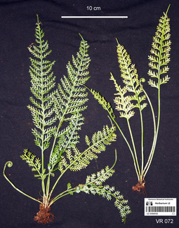
LE 01085103
Asplenium prolongatum Hook. det. Averyanov, Leonid Vladimirovich at 13.04.2018
Collectors: Averyanov, Leonid Vladimirovich; Khang Sinh Nguyen; Chuong Quang Ngan; Maisak, Tatiana Viktorovna Field collecting number: VR072. Collection date: 13.04.2018. Administrative regions: VN - Tinh Ha Giang. Groups of specimens: L. V. Averyanov specimens; L. V. Averyanov photos; L. V. Averyanov herbariumOriginal label text:FLORA OF VIETNAM Polypodiaceae s.l. Asplenium prolongatum Hook. Ha Giang prov., Quan Ba distr., Bat Dai Son commune, Bat Dai Son Nature Reserve, San Chu village, around point 23º08ʹ55.1ʺN 104º59ʹ45.7ʺE, 1000-1200 m a.s.l., karstic, highly eroded mountains composed of solid marble-like limestone, primary and partially degraded evergreen broad-leaved humid forest on rocky mountain slopes. Lithophyte of mossy vertical cliff, also occasionally epiphyte. Very common. 13 April 2018, L. Averyanov, Nguyen Sinh Khang, Chuong Quang Ngan, T. Maisak, VR 072.
Comment: All photos © L. Averyanov & K.S. Nguyen
Record creation: 2019-06-19, Аверьянов Леонид ВладимировичCitation: Specimen LE 01085103 // Virtual herbarium of Komarov Botanical Institute RAS — http://re.herbariumle.ru/01085103
LE 01093050
Asplenium oblanceolatum Copel. det. Cheng-Wei Chen
Collectors: Nuraliev, M. S. Field collecting number: NUR 51b. Collection date: 16.12.2009. Administrative regions: VN - Tinh Lao Cai. Original label text:Asplenium oblanceolatum Copel.
Det. Cheng-Wei Chen
photo
NORTHERN VIETNAM
Lao Cai Prov., Sa Pa Distr., San Sa Ho municip.,
Hoang Lien National Park, Cat Cat village area
Thac Bac river bank
N 22° 20' 20'' E 103° 49' 10'' elev. 1240 m
Nuraliev M.S. NUR 51b 16.12.2009
All photos © M. Nuraliev
Record creation: 2020-11-02, Nuraliev MaximCitation: Specimen LE 01093050 // Virtual herbarium of Komarov Botanical Institute RAS — http://re.herbariumle.ru/01093050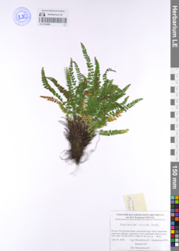
LE 01108099
Asplenium viride Huds. det. Melnikov, Denis Germanovich at 28.07.2018
Groups of specimens: Образцы сектора Восточной ЕвропыRecord creation: 2021-04-14, Denis Melnikov, PhotoScan D2. Processing status: data is not fully enteredCitation: Specimen LE 01108099 // Virtual herbarium of Komarov Botanical Institute RAS — http://re.herbariumle.ru/01108099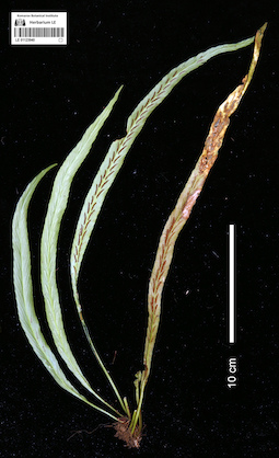
LE 01123940
Asplenium ensiforme Wall. det. Dong Shi Yong at 25.10.2022
Collectors: Nguyen Van Du; Khang Sinh Nguyen; et al. Field collecting number: LC-DKT-028. Collection date: 25.10.2022. Administrative regions: VN - Tinh Lao Cai. Groups of specimens: L. V. Averyanov herbarium; L. V. Averyanov photos; Flora of VietnamOriginal label text:FLORA OF VIETNAM
Aspleniaceae
Asplenium ensiforme ID by prof. Dong Shi Yong
Lao Cai prov., Sa Pa distr., Ngu Chi Son commune, on the trail to Ngu Chi Son mountain, around point from N22.42325º E103.75105º to N22.40975º E103.74072º, alt. 1800-2500 m a.s.l., primary evergreen broad-leaved humid forest on granite mountain.
Epiphytic herb. Rare
24-25 October 2022, Van Du Nguyen, Khang Sinh Nguyen, Xuan Thanh Trinh, Van Nam Vu, F. M. Scott, H. Daniel, W. Mark, T. Marchlik, LC-DKT 28
All photos © Nguyen Sinh Khang
Record creation: 2023-03-08, Аверьянов Леонид Владимирович. Processing status: work_status_1Citation: Specimen LE 01123940 // Virtual herbarium of Komarov Botanical Institute RAS — http://re.herbariumle.ru/01123940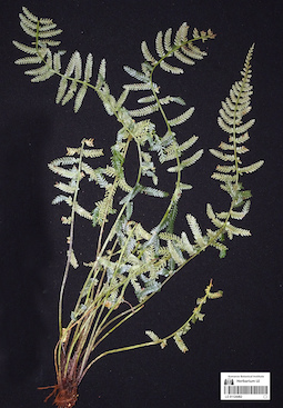
LE 01124462
Asplenium prolongatum Hook. det. Averyanov, Leonid Vladimirovich at 21.10.2023
Collectors: Cuong Huu Nguyen; Chu Ngoc Quan; Averyanov, Leonid Vladimirovich; Ly Van Nguyen; Maisak, Tatiana Viktorovna Field collecting number: AL2350. Collection date: 21.10.2023. Administrative regions: VN - Tinh Bac Kan. Groups of specimens: L. V. Averyanov specimens; L. V. Averyanov photos; Flora of VietnamOriginal label text:FLORA OF VIETNAM
Polypodiaceae s.l.
Asplenium prolongatum Hook.
Bac Kan Province, Ba Be District, Ba Be National Park. Dry evergreen broad-leaved secondary forest on cliffs composed by white crystalline marble-like highly eroded limestone along lake shore on point 22º24’58’’N 105º36’48’E at elev. of about 160 m a.s.l. Lithophytic fern on shady cliff. Not common.
21 October 2023, Nguyen Huu Cuong, Chu Ngoc Quan, L. Averyanov, Nguyen Van Ly, T. Maisak, AL2350.
All photos © - L. Averyanov
LE 01124683
Asplenium sp. det. Averyanov, Leonid Vladimirovich at 14.11.2023
Collectors: Averyanov, Leonid Vladimirovich; Nguyen Van Canh; Maisak, Tatiana Viktorovna Field collecting number: AL2800. Collection date: 14.11.2023. Administrative regions: VN - Tinh Lam GJong. Groups of specimens: L. V. Averyanov specimens; L. V. Averyanov photos; Flora of VietnamOriginal label text:FLORA OF VIETNAM
Polypodiaceae s.l. (Aspleniaceae)
Asplenium sp.
Lam Dong Province, Di Linh District, Brah Yang Mountain, primary and old secondary evergreen broad-leaved and mixed forest (with Pinus khasya) on granite around point 11º27.669ʹ N 108º03.543ʹ E at elevation of 1000-1100 m a.s.l. Lithophytic hern on wet stram rocks. Very common.
14 November 2023, L. Averyanov, Nguyen Van Canh, T. Maisak, AL2800.
All photos © - L. Averyanov