View
Add
Copy
Edit
Delete
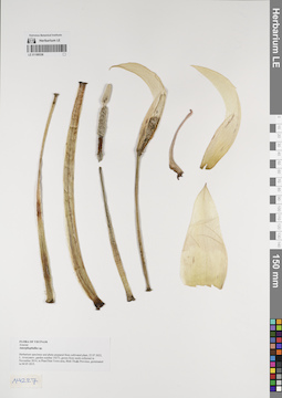
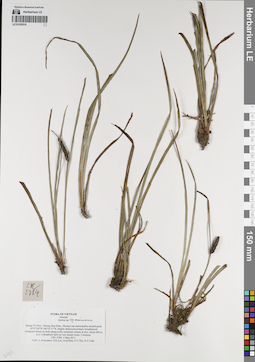
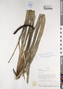
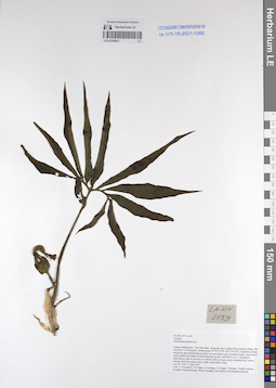
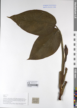
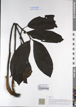
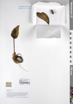
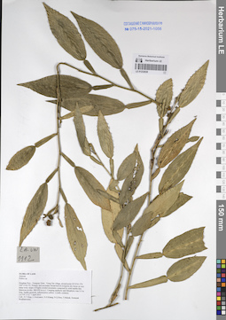
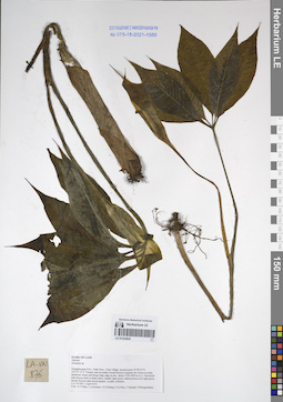
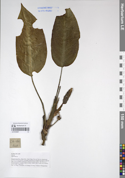
LE 01169336
Amorphophallus sp. det. Averyanov, Leonid Vladimirovich at 22.07.2022
Collectors: Averyanov, Leonid Vladimirovich Field collecting number: Averyanov s.n. g.n. 14273. Collection date: 22.07.2022. Administrative regions: VN - Tinh Binh Thuan. Groups of specimens: L. V. Averyanov specimens; L. V. Averyanov herbariumOriginal label text:FLORA OF VIETNAM
Araceae
Amorphophallus sp.
Herbarium specimen and photo prepared from cultivated plant, 22 07 2022, L. Averyanov, garden number 14273, grown from seeds collected in November 2014, in PhanThiet
Town area, Bình Thuận Province, germinated in 04 05 2015.
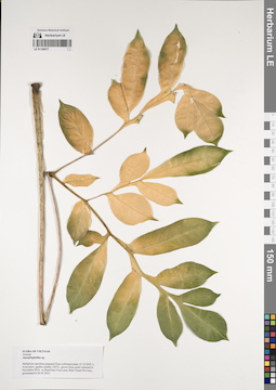
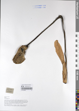
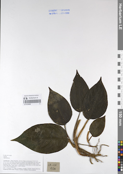
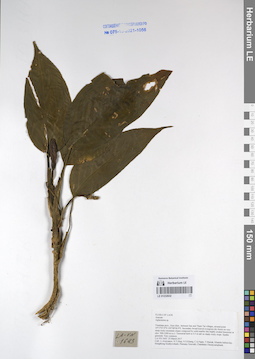
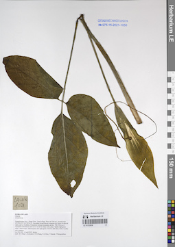
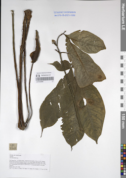
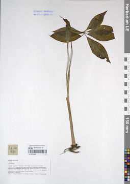
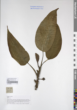
LE 01169577
Amorphophallus sp. det. Averyanov, Leonid Vladimirovich at 11.2014
Collectors: Averyanov, Leonid Vladimirovich Field collecting number: Garden number 14273. Collection date: 22.10.2022. Administrative regions: VN - Tinh Binh Thuan. Groups of specimens: L. V. Averyanov specimens; L. V. Averyanov herbariumOriginal label text:FLORA OF VIETNAM
Araceae
Amorphophallus sp.
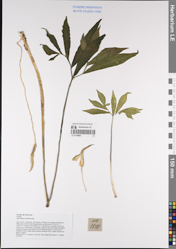
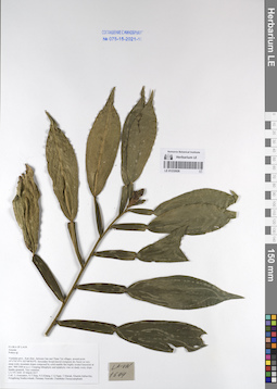
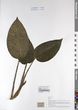
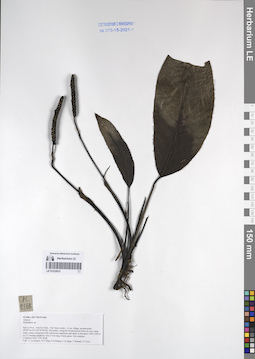
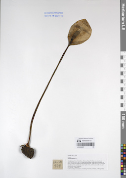
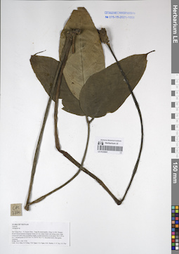
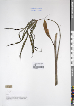
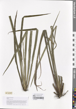
LE 01169656
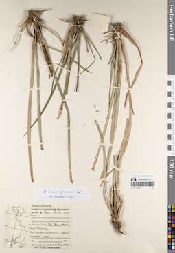
Sauromatum horsfieldii Miq. det. Averyanov, Leonid Vladimirovich at 26.05.2022
Collectors: Averyanov, Leonid Vladimirovich; Tran Huy Thai; Khang Sinh Nguyen; Maisak, Tatiana Viktorovna Field collecting number: VR1818. Collection date: 26.05.2022. Administrative regions: VN - Tinh Lao Cai. Groups of specimens: Образцы общего сектора; L. V. Averyanov specimens; L. V. Averyanov herbarium; Соглашение Минобрнауки №075-15-2021-1056Original label text:FLORA OF VIETNAM
Araceae
Sauromatum horsfieldii Miq.
Lao Cai Prov., Sapa Distr., the territory of Hoang Lien National Park allied to Sapa Town, route to Ham Rong mountain, around point N 22º20’02’’ E 103º50’55”, elevation 1600-1680 m a.s.l. Humid mossy secondary forest and scrub on very steep slopes of mountain composed with solid marble-like highly eroded limestone on the territory of town botanical garden. Terrestrial and lithophytic herb in shady places between limestone rocks. Spathe outside olive green. Common.
26 May 2022, L. Averyanov, Tran Huy Thai, Khang Sinh Nguyen, T. Maisak, VR 1818.

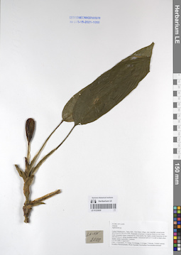
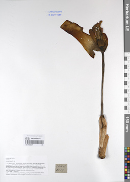
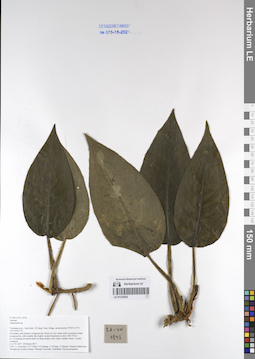
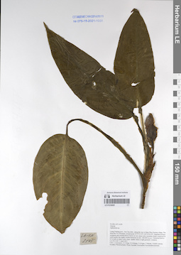
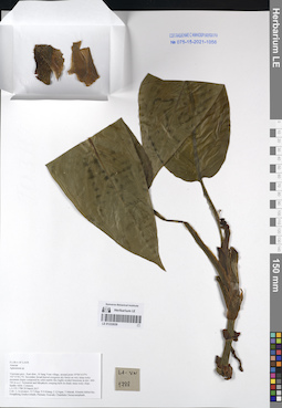
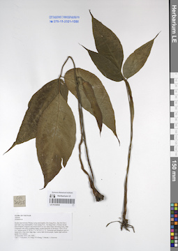
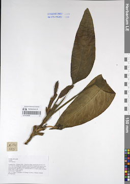
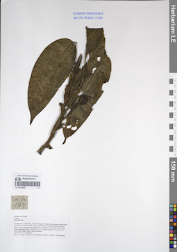
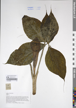
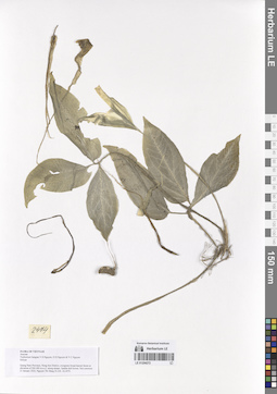
LE 01169657
Steudnera colocasiifolia K.Koch det. Averyanov, Leonid Vladimirovich at 16.05.2022
Collectors: Averyanov, Leonid Vladimirovich; Tran Huy Thai; Khang Sinh Nguyen; et al. Field collecting number: VR1685. Collection date: 16.05.2022. Administrative regions: VN - Tinh Dien Bien. Groups of specimens: Образцы общего сектора; L. V. Averyanov specimens; L. V. Averyanov herbarium; Соглашение Минобрнауки №075-15-2021-1056Original label text:FLORA OF VIETNAM
Araceae
Steudnera colocasiifolia K.Koch
Dien Bien Prov., Muong Nhe Distr., Muong Nhe Natural Reserve, Sin Thau Municipality, A Pa Chai Village around point about N22º22’50’’ E102º14’18”. Old humid secondary evergreen broad-leaved submontane forest of steep mountain slopes composed with sandstone at elevations 750–820 m a.s.l. along small stream. Terrestrial herb in wet place on very steep mountain slope. Inflorescence spathe brownish red. Occasional.
16 May 2022, L. Averyanov, Tran Huy Thai, Khang Sinh Nguyen, Cuong Huu Nguyen, T. Maisak, Bac Cam Khoa, VR 1685.
LE 01170248
Cleome chelidonii L.f. det. Cuong Huu Nguyen at 27.06.2022
Collectors: Cuong Huu Nguyen; et al. Field collecting number: CHKH20220627243. Collection date: 27.06.2022. Administrative regions: VN - Tinh Quang Nam. Groups of specimens: L. V. Averyanov specimens; L. V. Averyanov herbarium; Соглашение Минобрнауки №075-15-2021-1056Original label text:FLORA OF VIETNAM
Capparaceae
Cleome chelidonii L.f.
Quang Nam Province, Hoi An City area, Cu Lao Cham Islands, around 15°57'00.8"N 108°31'37.5"E. Secondary dry evergreen broad-leaved forest, at elevation 350 m a.s.l.
Perennial grass on open place. Very common.
27 June 2022, N.H.Cuong, D.V.Ha, N.S.Khang, C.X.Hai, CHKH20220627243.
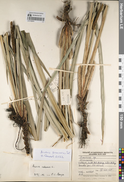
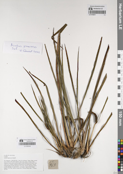
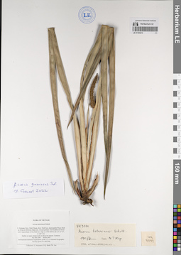
LE 01193016
Acorus gramineus Sol. det. Averyanov, Leonid Vladimirovich at 2011
Collectors: Averyanov, Leonid Vladimirovich; Phan Ke Loc; Nguyen Quang Hieu; Pham Van The; N.T.Vinh Field collecting number: 2784. Collection date: 05.05.2011. Administrative regions: VN - Vietnam. Subregion: Quang Tri Prov.. Place of collection: [Vietnam] Quang Tri Prov., Huong Hoa Distr., Huong Lap municipality around point 16°57'03''N, 106°35'17''E.Groups of specimens: Образцы общего сектора; Соглашение Минобрнауки №075-15-2021-1056; Flora of VietnamOriginal label text:Fam. Araceae. Acorus gramineus. Quang Tri Prov., Huong Hoa Distr., Huong Lap municipality around point 16°57'03''N, 106°35'17''E. Highly destroyed primary broadleaved evergreen forest on shale along rocky mountain stream at elev. about 600 m a.s.l. Lithophytic herb on wet stream rocks. Common. CPC 2784 5 May 2011 Coll. L. Averyanov, P.K. Loc, N.Q. Hieu, P.V. The, N.T. Vinh [Flora of Vietnam]
Landscape in location of collection: On shale along rocky mountain stream at elev. about 600 m a.s.l. Lithophytic herb on wet stream rocksHabitat / plant community in location of collecting: Highly destroyed primary broadleaved evergreen forestCoordinates (geographic position): 16° 57′ 3″ N, 106° 35′ 17″ E ±2000 mRecord creation: 2022-09-30, Larisa Orlova, PhotoScan D2.Citation: Specimen LE 01193016 // Virtual herbarium of Komarov Botanical Institute RAS — http://re.herbariumle.ru/01193016
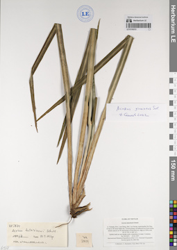
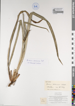
LE 01193017
Acorus gramineus Sol. det. Averyanov, Leonid Vladimirovich at 2005
Collectors: Averyanov, Leonid Vladimirovich; Phan Ke Loc; J. Regalado; T.V. Thao; N.T.Vinh Field collecting number: 7268. Collection date: 21.04.2005. Administrative regions: VN - Vietnam. Subregion: Thua Thien - Hue Prov.. Place of collection: Vietnam, Thua Thien - Hue Prov., A Luoi Distr., A Roang Municipality, Tra Lenh Forestry Department station, around point 16°04'41'' N, 107°29'06'' E.Groups of specimens: Образцы общего сектора; Соглашение Минобрнауки №075-15-2021-1056; Flora of VietnamOriginal label text:Fam. Araceae. Acorus gramineus Soland. Vietnam, Thua Thien - Hue Prov., A Luoi Distr., A Roang Municipality, Tra Lenh Forestry Department station, around point 16°04'41'' N, 107°29'06'' E. oPrimary closed evergreen broad-leaved forest on very steep mountain slopes composed with shale, sandstone and granite at elevation 700-800 m a.s.l. Lithophyte on wet rocks along rocky stream valley. Very common. Regular co-dominant of riparian lithophytic stream communities in the area. No HAL 7268 21 April 2005 Coll. L. Averyanov, P.K. Loc, J. Regaldo, T.V. Thao, N.T. Vinh [Flora of Vietnam]
Landscape in location of collection: On very steep mountain slopes composed with shale, sandstone and granite at elevation 700-800 m a.s.l. Lithophyte on wet rocks along rocky stream valleyHabitat / plant community in location of collecting: Primary closed evergreen broad-leaved forestCoordinates (geographic position): 16° 4′ 41″ N, 107° 29′ 6″ E ±2000 mRecord creation: 2022-09-30, Larisa Orlova, PhotoScan D2.Citation: Specimen LE 01193017 // Virtual herbarium of Komarov Botanical Institute RAS — http://re.herbariumle.ru/01193017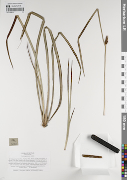
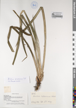
LE 01193018
Acorus gramineus Sol. det. Averyanov, Leonid Vladimirovich at 2002
Collectors: Averyanov, Leonid Vladimirovich; Phan Ke Loc; D.T. Doan Field collecting number: 2620. Collection date: 21.03.2002. Administrative regions: VN - Vietnam. Subregion: Lao Cai Prov.. Place of collection: N. Vietnam, Lao Cai Prov., Van Ban Distr., Khanh Yen municipality, to the SW of Na Nheo village (in the vicinity of point 21°57'59'' N, 104°14'06'' E).Groups of specimens: Образцы общего сектора; Соглашение Минобрнауки №075-15-2021-1056; Flora of VietnamOriginal label text:Fam. Araceae. Acorus gramineus Soland. N. Vietnam, Lao Cai Prov., Van Ban Distr., Khanh Yen municipality, to the SW of Na Nheo village (in the vicinity of point 21°57'59'' N, 104°14'06'' E). Primary evergreen broad-leaved montane forest with Fokienia hodginsii (as emergent) along granite and quartzite slopes at elev. 1800 m a.s.l. Lithophytic herb on wet mossy rocks along stream. Inflorescences dull yellow. Very common. Usual co-dominant of lithophytic herb riparian community. No HAL 2620 21 March 2002 Coll. L. Averyanov, P.K. Loc, D.T. Doan (FFI Project). [Flora of Vietnam]
Landscape in location of collection: along granite and quartzite slopes at elev. 1800 m a.s.l.Habitat / plant community in location of collecting: Primary evergreen broad-leaved montane forest with Fokienia hodginsii (as emergent)Coordinates (geographic position): 17° 45′ 27″ N, 105° 47′ 46″ E ±2000 mRecord creation: 2022-09-30, Larisa Orlova, PhotoScan D2.Citation: Specimen LE 01193018 // Virtual herbarium of Komarov Botanical Institute RAS — http://re.herbariumle.ru/01193018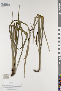
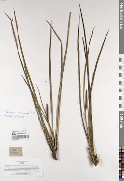
LE 01193024
Acorus gramineus Aiton det. Averyanov, Leonid Vladimirovich at 2009
Collectors: Averyanov, Leonid Vladimirovich; Phan Ke Loc; N.T.Vinh; L.T. Son Field collecting number: 12532. Collection date: 11.02.2009. Administrative regions: VN - Vietnam. Subregion: Quang Binh Prov.. Place of collection: [Vietnam] Quang Binh Prov., Minh Hoa Distr., Dan Hoa Municipality, to the EEN of Bai Dinh village around point 17°45'27' N, 105°47'46'' E..Groups of specimens: Образцы общего сектора; Соглашение Минобрнауки №075-15-2021-1056; Flora of VietnamOriginal label text:Araceae. Acorus gramineus? Quang Binh Prov., Minh Hoa Distr., Dan Hoa Municipality, to the EEN of Bai Dinh village around point 17°45'27'' N, 105°47'46'' E. Primary broad-leaved closed wet forest in very steep rocky slopes and cliffs of low remnant mountains composed with highly ... solid marble-like limestone at elevation about 600-700 m a.s.l. Lithophytic herb on wet mossy stream rocks. Inflorescences light yellowish to nearly white. Very common. HAL 12532 11 February 2009 Coll. L. Averyanov, P.K. Loc, N.T. Vinh, L.T. Son [Flora of Vietnam]
Habitat / plant community in location of collecting: Primary broad-leaved closed wet forestCoordinates (geographic position): 17° 45′ 27″ N, 105° 47′ 46″ E ±2000 mRecord creation: 2022-09-30, Larisa Orlova, PhotoScan D2.Citation: Specimen LE 01193024 // Virtual herbarium of Komarov Botanical Institute RAS — http://re.herbariumle.ru/01193024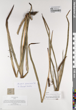
LE 01193207
Acorus gramineus Sol. det. Sokoloff, Dmitry Dmitrievich at 2022
Additional identifications: Acorus tatarinowii Schott det. Croat, Thomas Bernard at 2016 Collectors: Averyanov, Leonid Vladimirovich; et al. Field collecting number: HAL12075. Collection date: 08.01.2009. Administrative regions: VN - Tinh Quang Nam. Groups of specimens: Образцы общего сектора; Соглашение Минобрнауки №075-15-2021-1056; L. V. Averyanov specimensOriginal label text:FLORA OF VIETNAM
Araceae
Acorus sp.
Quang Nam Prov., Dong Giang Distr., Ma Cooih Municipality around point 15°49’07”N 107°39’51”E. Remnants of primary closed evergreen broad-leaved forests on steep slopes composed with shale at elevation 400-500 m a.s.l. Lithophytic herb on wet shady boulders along humid shady stream canyon. Inflorescences yellow-greenish. Very common.
HAL 12075 8 January 2009
Coll.: L.Averyanov, P.K.Loc, P.V.The, N.T.Vinh
LE 01193209
Acorus gramineus Sol. det. Sokoloff, Dmitry Dmitrievich at 2022
Additional identifications: Acorus tatarinowii Schott det. Averyanov, Leonid Vladimirovich at 23.04.2000 Collectors: Averyanov, Leonid Vladimirovich; et al. Field collecting number: VH5598. Collection date: 23.04.2000. Administrative regions: VN - Kon Tum. Groups of specimens: Образцы общего сектора; Соглашение Минобрнауки №075-15-2021-1056; L. V. Averyanov specimensOriginal label text:FLORA OF VIETNAM
Araceae
Acorus tatarinowii ?
S. Vietnam, Kontum Prov., Kon Plong Distr., Hieu Municipality, Mang La forest enterprise (14ø39'N, 108ø25'E). Primary broad-leaved closed evergreen wet mountain forest on sandstone steep slopes of forest river at elev. 1100-1200 m. Lithophytic herb on wet mossy rocks along forest river. Common.
No VH 5598 23.04.2000
International Botanical Expedition of the U.S.A. National Geographic Society (grant No 6383-98)
Collectors: L.Averyanov, P.H.Hoang, D.X.Du, N.T.Vinh
LE 01193210
Acorus gramineus Sol. det. Sokoloff, Dmitry Dmitrievich at 2022
Additional identifications: Acorus calamus L. det. Boyce, P.C. at 03.09.1992 Collectors: Averyanov, Leonid Vladimirovich; et al. Field collecting number: LX-VN 1126. Collection date: 02.01.1983. Administrative regions: VN - Tinh Lam GJong. Groups of specimens: Образцы общего сектора; Соглашение Минобрнауки №075-15-2021-1056; L. V. Averyanov specimensOriginal label text:FLORA OF VIETNAM
Record creation: 2022-10-08, Larisa Orlova, PhotoScan D2. Part 1.. Processing status: work_status_1Citation: Specimen LE 01193210 // Virtual herbarium of Komarov Botanical Institute RAS — http://re.herbariumle.ru/01193210Araceae
Acorus sp.
Vietnam, Ca Do, Don Duong, Lam Dong.
1983 2 I LX-VN 1126
LE 01193211
Acorus gramineus Sol. det. Sokoloff, Dmitry Dmitrievich at 2022
Additional identifications: Acorus tatarinowii Schott det. Averyanov, Leonid Vladimirovich at 23.04.2018 Collectors: Averyanov, Leonid Vladimirovich; et al. Field collecting number: VR763. Collection date: 23.04.2018. Administrative regions: VN - Tinh Ha Giang. Groups of specimens: Образцы общего сектора; Соглашение Минобрнауки №075-15-2021-1056; L. V. Averyanov specimensOriginal label text:FLORA OF VIETNAM
Araceae
Acorus tatarinowii Schott?
Ha Giang prov., Quan Ba distr., Tung Vai commune, Thang village, around point 23º03ʹ13.4ʺN 104º51ʹ48.8ʺE, steep rocky slopes of stream valley composed with eroded stratified highly eroded limestone at elevation 1000-1200 m a.s.l. Primary evergreen broad-leaved very humid forest. Densely clustering herb on open wet mossy river rocks. Flowers yellowish to green. Locally abundant. 23 April 2018, L. Averyanov, Nguyen Sinh Khang, Nguyen Tien Hiep, Nguyen Quang Hieu, Chuong Quang Ngan, T. Maisak, VR 763.
LE 01193212
Acorus gramineus Sol. det. Sokoloff, Dmitry Dmitrievich at 2022
Additional identifications: Acorus tatarinowii Schott det. Averyanov, Leonid Vladimirovich at 19.03.1997 Collectors: Averyanov, Leonid Vladimirovich; et al. Field collecting number: VH2874. Collection date: 19.03.1997. Administrative regions: VN - Tinh Lam GJong. Groups of specimens: Образцы общего сектора; Соглашение Минобрнауки №075-15-2021-1056; L. V. Averyanov specimensOriginal label text:FLORA OF VIETNAM
Araceae
Acorus tatarinowi Schott
S. Vietnam, Prov. Lam Dong, distr. Lac Duong, municipalite Da Chay, 35 km to NE from Dalat city. Closed primary broadleaved mt forest along stream canyon on W macroslope of Gia Rinh mt. ridge at 1500 m alt. (N 12° 09', E 108° 41').
Epilitic herb on wet stream rocks, sometimes in water. Common.
No VH 2874 19.03.1997
International Botanical Expedition of the U.S.A. National Geographic Society (grant No 5803-96)
Collectors: L. Averyanov, N.Q. Binh, P.K. Loc
LE 01193213
Acorus gramineus Sol. det. Sokoloff, Dmitry Dmitrievich at 2022
Additional identifications: Acorus tatarinowii Schott det. Averyanov, Leonid Vladimirovich at 04.04.1997 Collectors: Averyanov, Leonid Vladimirovich; et al. Field collecting number: VH3599. Collection date: 04.04.1997. Administrative regions: VN - Tinh Ninh Thuan. Groups of specimens: Образцы общего сектора; Соглашение Минобрнауки №075-15-2021-1056; L. V. Averyanov specimensOriginal label text:FLORA OF VIETNAM
Araceae
Acorus tatarinowi Schott
S. Vietnam, Prov. Ninh Thuan, distr. Ninh Son, municipalite Phuoc Binh in 34 km to NE from Dalat city. Closed primary wet broadleaved forest om E macroslope of Gia Rich mt. ridge at 1700-1800 m alt. (N 12° 07', E 108° 42'). Epilite on open stream rocks in deep mt canyon. Common.
No VH 3599 04.04.1997
International Botanical Expedition of the U.S.A. National Geographic Society (grant No 5803-96)
Collectors: L. Averyanov, N.Q. Binh, P.K. Loc
LE 01193214
Acorus gramineus Sol. det. Sokoloff, Dmitry Dmitrievich at 2022
Additional identifications: Acorus tatarinowii Schott det. Averyanov, Leonid Vladimirovich at 11.03.1997 Collectors: Averyanov, Leonid Vladimirovich; et al. Field collecting number: VH2496. Collection date: 11.03.1997. Administrative regions: VN - Tinh Lam GJong. Groups of specimens: Образцы общего сектора; Соглашение Минобрнауки №075-15-2021-1056; L. V. Averyanov specimensOriginal label text:FLORA OF VIETNAM
Araceae
Acorus tatarinowi Schott
S. Vietnam, Prov. Lam Dong, 14 km to NNW from Dalat city (N 12° 05', E 108° 22'). Primary closed mixed forest with Pinus kesiya and P. krempfii at 1740-1760 m alt. Epilitic herb along stream on wet crevices of granitic rocks. Common.
No VH 2496 11.03.1997
International Botanical Expedition of the U.S.A. National Geographic Society (grant No 5803-96)
Collectors: L. Averyanov, N.Q. Binh, N.V. Duy, P.K. Loc
LE 01193215
Acorus gramineus Sol. det. Sokoloff, Dmitry Dmitrievich at 2022
Additional identifications: Acorus tatarinowii Schott det. Averyanov, Leonid Vladimirovich at 23.02.1995 Collectors: Averyanov, Leonid Vladimirovich; et al. Field collecting number: VH0015. Collection date: 23.02.1995. Administrative regions: VN - Kon Tum. Groups of specimens: Образцы общего сектора; Соглашение Минобрнауки №075-15-2021-1056; L. V. Averyanov specimensOriginal label text:FLORA OF VIETNAM
Araceae Juss.
Acorus tatarinowii Schott.
S. Vietnam, Prov. Kontum. NW slopes of Ngoc Linh mountain system at 1200 m alt. near Ngoc Linh village. On rocky mountain stream side in evergreen primary forest. Herb up to 0.7 m high.
No VH 015 23.02.1995
International Botanical Expedition of the U.S.A. National Geographic Society (grant No 5094-93)
L. Averyanov, N.T. Ban, N. Q. Binh, A. Budantzev, L. Budantzev, N.T. Hiep, D.D. Huyen, P.K. Loc, N.X. Tam, G. Yakovlev
LE 01193216
Acorus gramineus Sol. det. Averyanov, Leonid Vladimirovich at 2022
Additional identifications: Acorus sp. det. Averyanov, Leonid Vladimirovich at 08.02.2009 Collectors: Averyanov, Leonid Vladimirovich; et al. Field collecting number: HAL12409. Collection date: 08.02.2009. Administrative regions: VN - Tinh Quang Binh. Groups of specimens: Образцы общего сектора; Соглашение Минобрнауки №075-15-2021-1056; L. V. Averyanov specimensOriginal label text:FLORA OF VIETNAM
Araceae
Acorus sp.
Quang Binh Prov., Minh Hoa Distr., Dan Hoa Municipality, Giang Man Ridge (Vietnam-Laos border) near Cha Lo Vietnam-Lao border gate around point 17°41’50”N 105°45’54”E. Primary evergreen broad-leaved and coniferous (with Dacrycarpus and Fokienia) wet forest along ridge edge composed with shale and sandstone at elevation about 900-1100 m a.s.l. Lithophytic herb on wet mossy stream rocks. Inflorescence yellowish. Common.
HAL 12409 8 February 2009
Coll.: L.Averyanov, P.K.Loc, N.T.Vinh, L.T.Son.
LE 01193217
Acorus gramineus Sol. det. Sokoloff, Dmitry Dmitrievich at 2022
Additional identifications: Acorus sp. det. Averyanov, Leonid Vladimirovich Collectors: Unknown Field collecting number: 0021. Collection date: 23.11.1969. Administrative regions: VN - Tinh Ninh Binh. Groups of specimens: Образцы общего сектора; Соглашение Минобрнауки №075-15-2021-1056; L. V. Averyanov specimensOriginal label text:FLORA VIETNAMICA
Record creation: 2022-10-08, Larisa Orlova, PhotoScan D2. Part 1.. Processing status: work_status_1Citation: Specimen LE 01193217 // Virtual herbarium of Komarov Botanical Institute RAS — http://re.herbariumle.ru/01193217Araceae
Acorus
N Vietnam, Prov. Yf Nam Ninh, Cuc Phuong.
№ 0021 23.11.1969
LE 01232620
Aglaonema sp. det. Averyanov, Leonid Vladimirovich at 02.04.2017
Collectors: Averyanov, Leonid Vladimirovich; et al. Field collecting number: LA-VN2000. Collection date: 02.04.2017. Administrative regions: LA - Luang Prabang Province. Groups of specimens: L. V. Averyanov specimens; L. V. Averyanov herbarium; Соглашение Минобрнауки №075-15-2021-1056; Flora of LaosOriginal label text:FLORA OF LAOS
Araceae
Aglaonema sp.
Luang Prabang prov., Ngoy distr., Don Khun village, near waterfall, around point 20°31'36.9''N 102°35'15.8''E.
Remnants of primary evergreen forest on very steep rocky mountain slopes composed by solid marble like highly eroded limestone at elev. 450-550 m a.s.l. along mountain stream. Terrestrial herb to 0.5 m tall in shady place. Spathe white to greenish. Common. LA-VN 2000 2 April 2017
Coll.: L.Averyanov, N.T.Hiep, N.S.Khang, C.Q.Ngan, T.Maisak, Vichith Lamxay, Koudkeo Phommachanh, Phizar Sayalath, Keooudone Souvannakhoummane.
LE 01232621
Amorphophallus sp. det. Averyanov, Leonid Vladimirovich at 04.04.2017
Collectors: Averyanov, Leonid Vladimirovich; et al. Field collecting number: LA-VN2048. Collection date: 04.04.2017. Administrative regions: LA - Luang Prabang Province. Groups of specimens: L. V. Averyanov specimens; L. V. Averyanov herbarium; Соглашение Минобрнауки №075-15-2021-1056; Flora of LaosOriginal label text:FLORA OF LAOS
Araceae
Amorphophallus sp.
Luang Prabang prov., Pon Xay distr., Houay Man village, Phou Pak Sang Mountain, around point 19°59'03.8''N 102°25'09.0''E.
Degraded primary evergreen and semideciduous forest on very steep rocky mountain slopes composed by solid marble like highly eroded limestone at elev. 1000-1150 m a.s.l. Ephemeroid tuberiferous herb with leafless inflorescence to 0.5 m tall on rocky slope near mountain top. Spathe white with pink apex. Peduncle olive with whitish spots. Rare.
LA-VN 2048 4 April 2017
Coll.: L.Averyanov, N.T.Hiep, N.S.Khang, C.Q.Ngan, T.Maisak, Vichith Lamxay, Koudkeo Phommachanh, Phizar Sayalath, Keooudone Souvannakhoummane.
LE 01232622
Aglaonema sp. det. Averyanov, Leonid Vladimirovich at 18.03.2017
Collectors: Averyanov, Leonid Vladimirovich; et al. Field collecting number: LA-VN1837. Collection date: 18.03.2017. Administrative regions: LA - Vientiane Province. Groups of specimens: L. V. Averyanov specimens; L. V. Averyanov herbarium; Соглашение Минобрнауки №075-15-2021-1056; Flora of LaosOriginal label text:FLORA OF LAOS
Araceae
Aglaonema sp.
Vientiane prov., Kasi distr., Si Sang Vone village, around point 19°06'10.9''N 102°10'46.1''E.
Secondary and primary evergreen dry forest on very steep rocky mountain slopes composed by solid marble like highly eroded limestone at elev. 600-750 m a.s.l. Creeping terrestrial herb on steep shady rocky slope. Spathe white. Locally common.
LA-VN 1837 28 March 2017
Coll.: L.Averyanov, N.T.Hiep, N.S.Khang, C.Q.Ngan, T.Maisak, Khamla Inkhavilay, Hongthong Southyvohanh, Pinmany Sisavath, Chanthala Cheuaysamphanh.
LE 01232623
Pseudodracontium sp. ⟮prelim. ID⟯ det. Averyanov, Leonid Vladimirovich at 05.04.2017
Collectors: Averyanov, Leonid Vladimirovich; et al. Field collecting number: LA-VN2159. Collection date: 05.04.2017. Administrative regions: LA - Luang Prabang Province. Groups of specimens: L. V. Averyanov specimens; L. V. Averyanov herbarium; Соглашение Минобрнауки №075-15-2021-1056; Flora of LaosOriginal label text:FLORA OF LAOS
Araceae
Pseudodraconthium sp.?
Luang Prabang prov., Pon Xay distr., along the way to Bane Phou Souong village, Pha Hiua Bin Toc Mountain, around point 19°57'37.0''N 102°25'03.0''E. Degraded primary evergreen and semideciduous forest on very steep rocky mountain slopes composed by solid marble like highly eroded limestone at elev. 600-850 m a.s.l. Lithophytic tuberiferous herb in crevices of vertical cliff on mossy rocky mountain top. Leaves velvety dark blue-green above, dark violet below. Rare.
LA-VN 2159 5 April 2017
Coll.: L.Averyanov, N.T.Hiep, N.S.Khang, C.Q.Ngan, T.Maisak, Vichith Lamxay, Koudkeo Phommachanh, Phizar Sayalath, Keooudone Souvannakhoummane.
LE 01232624
Amorphophallus sp. det. Averyanov, Leonid Vladimirovich at 06.04.2017
Collectors: Averyanov, Leonid Vladimirovich; et al. Field collecting number: LA-VN2186. Collection date: 06.04.2017. Administrative regions: LA - Luang Prabang Province. Groups of specimens: L. V. Averyanov specimens; L. V. Averyanov herbarium; Соглашение Минобрнауки №075-15-2021-1056; Flora of LaosOriginal label text:FLORA OF LAOS
Araceae
Amorphophallus sp.
Luang Prabang prov., Pon Xay distr., Nam Bo village, around point 19°57'23.5''N 102°26'16.4''E.
Degraded primary evergreen and semideciduous forest on very steep rocky mountain slopes composed by solid marble like highly eroded limestone at elev. 650-750 m a.s.l. Terrestrial ephemeroid tuberiferous herb on rocky mountain slope. Leafless peduncle olive=-brownish with whitish spots. Not common.
LA-VN 2186 6 April 2017
Coll.: L.Averyanov, N.T.Hiep, N.S.Khang, C.Q.Ngan, T.Maisak, Vichith Lamxay, Koudkeo Phommachanh, Phizar Sayalath, Keooudone Souvannakhoummane.
LE 01232625
Aglaonema sp. det. Averyanov, Leonid Vladimirovich at 05.04.2017
Collectors: Averyanov, Leonid Vladimirovich; et al. Field collecting number: LA-VN2145. Collection date: 05.04.2017. Administrative regions: LA - Luang Prabang Province. Groups of specimens: L. V. Averyanov specimens; L. V. Averyanov herbarium; Соглашение Минобрнауки №075-15-2021-1056; Flora of LaosOriginal label text:FLORA OF LAOS
Araceae
Aglaonema sp.
Luang Prabang prov., Pon Xay distr., along the way to Bane Phou Souong village, Pha Hiua Bin Toc Mountain, around point 19°57'37.0''N 102°25'03.0''E. Degraded primary evergreen and semideciduous forest on very steep rocky mountain slopes composed by solid marble like highly eroded limestone at elev. 600-850 m a.s.l.
Terrestrial herb to 0.5 m tall on shady rocky slope. Spathe white to light greenish. Common.
LA-VN 2145 5 April 2017
Coll.: L.Averyanov, N.T.Hiep, N.S.Khang, C.Q.Ngan, T.Maisak, Vichith Lamxay, Koudkeo Phommachanh, Phizar Sayalath, Keooudone Souvannakhoummane.
LE 01232626
Pothos sp. det. Averyanov, Leonid Vladimirovich at 25.03.2017
Collectors: Averyanov, Leonid Vladimirovich; et al. Field collecting number: LA-VN1644. Collection date: 25.03.2017. Administrative regions: LA - Vientiane Province. Groups of specimens: L. V. Averyanov specimens; L. V. Averyanov herbarium; Соглашение Минобрнауки №075-15-2021-1056; Flora of LaosOriginal label text:FLORA OF LAOS
Araceae
Pothos sp.
Vientiane prov., Kasi distr., between San and Tham Tai villages, around point 19°17'47.9''N 102°08'58.9''E.
Secondary broad-leaved evergreen dry forest on very steep rocky mountain slopes composed by solid marble like highly eroded limestone at elev. 900-1000 m a.s.l. Creeping lithophytic and epiphytic vine on shady rocky slope. Spathe greenish. Very common.
LA-VN 1644 25 March 2017
Coll.: L.Averyanov, N.T.Hiep, N.S.Khang, C.Q.Ngan, T.Maisak, Khamla Inkhavilay, Hongthong Southyvohanh, Pinmany Sisavath, Chanthala Cheuaysamphanh.
LE 01232627
Aglaonema sp. det. Averyanov, Leonid Vladimirovich at 22.03.2017
Collectors: Averyanov, Leonid Vladimirovich; et al. Field collecting number: LA-VN1547. Collection date: 22.03.2017. Administrative regions: LA - Vientiane Province. Groups of specimens: L. V. Averyanov specimens; L. V. Averyanov herbarium; Соглашение Минобрнауки №075-15-2021-1056; Flora of LaosOriginal label text:FLORA OF LAOS
Araceae
Aglaonema sp.
Vientiane prov., Vang Vieng distr., Oa Hom village, around point 19°05'57.0''N 102°23'19.9''E.
Secondary broad-leaved evergreen and semideciduous dry forest with on very steep rocky mountain slopes composed by solid marble like highly eroded limestone at elev. 650-750 m a.s.l. Terrestrial herb in shady place on rocky slope. Spathe white to greenish. Common.
LA-VN 1547 22 March 2017
Coll.: L.Averyanov, N.T.Hiep, N.S.Khang, C.Q.Ngan, T.Maisak, Khamla Inkhavilay, Hongthong Southyvohanh, Pinmany Sisavath, Chanthala Cheuaysamphanh.
LE 01232628
Aglaonema sp. det. Averyanov, Leonid Vladimirovich at 22.03.2017
Collectors: Averyanov, Leonid Vladimirovich; et al. Field collecting number: LA-VN1530. Collection date: 22.03.2017. Administrative regions: LA - Vientiane Province. Groups of specimens: L. V. Averyanov specimens; L. V. Averyanov herbarium; Соглашение Минобрнауки №075-15-2021-1056; Flora of LaosOriginal label text:FLORA OF LAOS
Araceae
Aglaonema sp.
Vientiane prov., Vang Vieng distr., Oa Hom village, around point 19°05'57.0''N 102°23'19.9''E.
Secondary broad-leaved evergreen and semideciduous dry forest with on very steep rocky mountain slopes composed by solid marble like highly eroded limestone at elev. 650-750 m a.s.l. Creeping herb in shady places on rocky steep slope. Leaves dark green, spathe white. Locally common.
LA-VN 1530 22 March 2017
Coll.: L.Averyanov, N.T.Hiep, N.S.Khang, C.Q.Ngan, T.Maisak, Khamla Inkhavilay, Hongthong Southyvohanh, Pinmany Sisavath, Chanthala Cheuaysamphanh.
LE 01232629
Aglaonema sp. det. Averyanov, Leonid Vladimirovich at 25.03.2017
Collectors: Averyanov, Leonid Vladimirovich; et al. Field collecting number: LA-VN1633. Collection date: 25.03.2017. Administrative regions: LA - Vientiane Province. Groups of specimens: L. V. Averyanov specimens; L. V. Averyanov herbarium; Соглашение Минобрнауки №075-15-2021-1056; Flora of LaosOriginal label text:FLORA OF LAOS
Araceae
Aglaonema sp.
Vientiane prov., Kasi distr., between San and Tham Tai villages, around point 19°17'47.9''N 102°08'58.9''E.
Secondary broad-leaved evergreen dry forest on very steep rocky mountain slopes composed by solid marble like highly eroded limestone at elev. 900-1000 m a.s.l. Terrestrial creeping herb on shady stream rocky slope. Spathe white, leaves dark glossy green. Not rare.
LA-VN 1633 25 March 2017
Coll.: L.Averyanov, N.T.Hiep, N.S.Khang, C.Q.Ngan, T.Maisak, Khamla Inkhavilay, Hongthong Southyvohanh, Pinmany Sisavath, Chanthala Cheuaysamphanh.
LE 01232630
Aglaonema sp. det. Averyanov, Leonid Vladimirovich at 28.03.2017
Collectors: Averyanov, Leonid Vladimirovich; et al. Field collecting number: LA-VN1788. Collection date: 28.03.2017. Administrative regions: LA - Vientiane Province. Groups of specimens: L. V. Averyanov specimens; L. V. Averyanov herbarium; Соглашение Минобрнауки №075-15-2021-1056; Flora of LaosOriginal label text:FLORA OF LAOS
Araceae
Aglaonema sp.
Vientiane prov., Kasi distr., Si Sang Vone village, around point 19°06'10.9''N 102°10'46.1''E.
Secondary broad-leaved evergreen dry forest on very steep rocky mountain slopes composed by solid marble like highly eroded limestone at elev. 600-700 m a.s.l. Terrestrial and lithophytic creeping herb on shady steep rocky slope. Spathe white. Common.
LA-VN 1788 28 March 2017
Coll.: L.Averyanov, N.T.Hiep, N.S.Khang, C.Q.Ngan, T.Maisak, Khamla Inkhavilay, Hongthong Southyvohanh, Pinmany Sisavath, Chanthala Cheuaysamphanh.
LE 01232631
Amorphophallus sp. det. Averyanov, Leonid Vladimirovich at 23.03.2017
Collectors: Averyanov, Leonid Vladimirovich; et al. Collection date: 23.03.2017. Administrative regions: LA - Vientiane Province. Groups of specimens: L. V. Averyanov specimens; L. V. Averyanov herbarium; Соглашение Минобрнауки №075-15-2021-1056; Flora of LaosOriginal label text:FLORA OF LAOS
Araceae
Amorphophallus sp.
Vientiane prov., Vang Vieng distr., Patang village, around point 19°04'15.6''N 102°24'33.2''E.
Secondary broad-leaved semi-deciduous dry forest on very steep rocky mountain slopes composed by solid marble like highly eroded limestone at elev. about 670 m a.s.l. Terrestrial and lithophytic tuberiferous herb. Spathe greenish. Common.
LA-VN 1580 23 March 2017
Coll.: L.Averyanov, N.T.Hiep, N.S.Khang, C.Q.Ngan, T.Maisak, Khamla Inkhavilay, Hongthong Southyvohanh, Pinmany Sisavath, Chanthala Cheuaysamphanh.
LE 01232632
Aglaonema sp. det. Averyanov, Leonid Vladimirovich at 25.03.2017
Collectors: Averyanov, Leonid Vladimirovich; et al. Field collecting number: LA-VN1643. Collection date: 25.03.2017. Administrative regions: LA - Vientiane Province. Groups of specimens: L. V. Averyanov specimens; L. V. Averyanov herbarium; Соглашение Минобрнауки №075-15-2021-1056; Flora of LaosOriginal label text:FLORA OF LAOS
Araceae
Aglaonema sp.
Vientiane prov., Kasi distr., between San and Tham Tai villages, around point 19°17'47.9''N 102°08'58.9''E.
Secondary broad-leaved evergreen dry forest on very steep rocky mountain slopes composed by solid marble like highly eroded limestone at elev. 900-1000 m a.s.l. Terrestrial herb to 0.5 m tall on shady rocky slope. Spathe greenish. Very common.
LA-VN 1643 25 March 2017
Coll.: L.Averyanov, N.T.Hiep, N.S.Khang, C.Q.Ngan, T.Maisak, Khamla Inkhavilay, Hongthong Southyvohanh, Pinmany Sisavath, Chanthala Cheuaysamphanh.
LE 01232633
Scindapsus sp. det. Averyanov, Leonid Vladimirovich at 01.10.2016
Collectors: Averyanov, Leonid Vladimirovich; et al. Field collecting number: CPC8168. Collection date: 01.10.2016. Administrative regions: VN - Tinh Son La. Groups of specimens: L. V. Averyanov specimens; L. V. Averyanov herbarium; Соглашение Минобрнауки №075-15-2021-1056; Flora of VietnamOriginal label text:FLORA OF VIETNAM
Araceae
Scindapsus sp.
Son La Prov., Van Ho Distr., Tan Xuan comm., A Lay village, around point 20°40’46.2N 104°39’49.6E.
Secondary evergreen broad-leaved forest on very steep rocky slopes composed with red-brown sandstone and shale at elevation 1300-1500 m a.s.l. Creeping epiphytic vine 3-4 m long. Fruits green. Not common.
1 October 2016 CPC 8168
Coll.: L.Averyanov, N.T.Hiep, N.S.Khang, C.Q.Ngan, T.V.Maisak, N.T.Son.
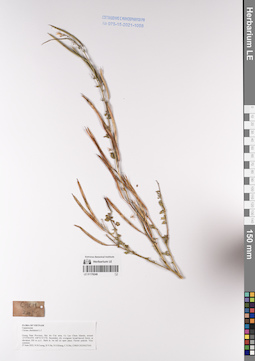
LE 01232634
Arisaema sp. det. Averyanov, Leonid Vladimirovich at 14.11.2014
Collectors: Averyanov, Leonid Vladimirovich; et al. Field collecting number: CPC7435. Collection date: 14.11.2014. Administrative regions: VN - Tinh Ha Giang. Groups of specimens: L. V. Averyanov specimens; L. V. Averyanov herbarium; Соглашение Минобрнауки №075-15-2021-1056; Flora of VietnamOriginal label text: FLORA OF VIETNAM
Araceae.
Arisaema sp.
Border area between Phieng Luong municipality (Ha Giang Prov., Bac Me Distr.) and Sinh Long municipalitiy (Tuen Quang Prov., Na Hang Distr.). Primary broad-leaved humid evergreen and mixed forest on very steep slopes and along rocky ridge composed with solid crystalline highly eroded limestone at elevation 1100-1170 m a.s.l. around point 22°38’24.3’’N 105°20’21.3’’E. Terrestrial and lithophytic herb on steep rocky slope near ridge edge. Leaves dark brown-purple. Spathe light uniform green. Not common. 14 November 2014 CPC 7435 Coll.: L.Averyanov, N.T.Hiep, N.S.Khang, T.Maisak, L.Osinovetz
LE 01232635
Amorphophallus sp. det. Tien Hiep Nguyen at 04.04.2015
Collectors: Tien Hiep Nguyen; et al. Field collecting number: LA-VN1026. Collection date: 04.04.2015. Administrative regions: LA - Xiangkhouang. Groups of specimens: L. V. Averyanov specimens; L. V. Averyanov herbarium; Соглашение Минобрнауки №075-15-2021-1056; Flora of LaosOriginal label text:FLORA OF LAOS
Araceae
Amorphophallus sp.
Xiangkhouang Prov., Kham Distr., Huad village, Phou tat Vinh mt., around point 19°32'31.6'N 103°39'40.4'E.
Primary and secondary broad-leaved evergreen and semideciduous dry forest on very steep rocky slopes of limestone highly eroded mountains composed by solid marble like limestone at elev. 1200-1400 m a.s.l. Tuberiferous terrerstrial and lithophytic herb. Spathe white. Occasional.
LA-VN 1026 4 April 2015
Coll.: N.T.Hiep, L.Averyanov, N.S.Khang, N.Q.Hieu, T.Maisak, Pheng Phengsintham.
LE 01232636
Arisaema sp. det. Tien Hiep Nguyen at 04.04.2015
Collectors: Tien Hiep Nguyen; et al. Field collecting number: LA-VN1021. Collection date: 04.04.2015. Administrative regions: LA - Xiangkhouang. Groups of specimens: L. V. Averyanov specimens; L. V. Averyanov herbarium; Соглашение Минобрнауки №075-15-2021-1056; Flora of LaosOriginal label text:FLORA OF LAOS
Araceae
Arisaema sp.
Xiangkhouang Prov., Kham Distr., Huad village, Phou tat Vinh mt., around point 19°33'02.2'N 103°39'56.3'E.
Secondary broad-leaved evergreen dry forest on alluvial valley and on foothills of limestone remnant mountains at elev. 700-750 m a.s.l. Terrestrial tuberiferous herb to 0.5 m tall in shady rocky place. Spathe light green with 3 white stripes. Inflorescence axis light green. Flowers dark dirty violet. Locally very common.
LA-VN 1021 4 April 2015 photos
Coll.: N.T.Hiep, L.Averyanov, N.S.Khang, N.Q.Hieu, T.Maisak, Pheng Phengsintham.
LE 01232637
Amorphophallus sp. det. Tien Hiep Nguyen at 03.04.2015
Collectors: Tien Hiep Nguyen; et al. Field collecting number: LA-VN978. Collection date: 03.04.2015. Administrative regions: LA - Xiangkhouang. Groups of specimens: L. V. Averyanov specimens; L. V. Averyanov herbarium; Соглашение Минобрнауки №075-15-2021-1056; Flora of LaosOriginal label text:FLORA OF LAOS
Araceae
Amorphophallus sp.
Xiangkhouang Prov., Peak Distr., Khoang village, Pa Khao mt., around point 19°33’02.2’N 103°39’56.3’E.
Primary and secondary broad-leaved evergreen dry forest on solid rocky highly eroded limestone at elev. 1200-1450 m a.s.l.
Terrestrial tuberiferous herb on shady dry slope. Spathe white, inflorescence stalk with dull olive-brown spots. Occasional.
LA-VN 978 3 April 2015
Coll.: N.T.Hiep, L.Averyanov, N.S.Khang, N.Q.Hieu, T.Maisak, Pheng Phengsintham.
LE 01232638
Aglaonema sp. det. Tien Hiep Nguyen at 07.04.2015
Collectors: Tien Hiep Nguyen; et al. Field collecting number: LA-VN1113. Collection date: 07.04.2015. Administrative regions: LA - Lao People's Democratic Republic. Groups of specimens: L. V. Averyanov specimens; L. V. Averyanov herbarium; Соглашение Минобрнауки №075-15-2021-1056; Flora of LaosOriginal label text:FLORA OF LAOS
Araceae
Aglaonema sp.
Houphan Prov., Viengxay Distr., Vieng Xai village, around point 20°23'41.3''N 104°13'44.5''E.
Primary and secondary broad-leaved evergreen dry forest on very steep rocky slopes of highly eroded mountains composed by solid marble-like limestone at elev. 800-950 m a.s.l. Terrestrial herb to 0.5 m tall in shady wet place. Spathe white. Locally common.
LA-VN 1113 7 April 2015
Coll.: N.T.Hiep, L.Averyanov, N.S.Khang, N.Q.Hieu, T.Maisak, Somneuk Bouthamounty.
LE 01232639
Pothos sp. det. Tien Hiep Nguyen at 07.04.2015
Collectors: Tien Hiep Nguyen; et al. Field collecting number: LA-VN1112. Collection date: 07.04.2015. Administrative regions: LA - Houaphan. Groups of specimens: L. V. Averyanov specimens; L. V. Averyanov herbarium; Соглашение Минобрнауки №075-15-2021-1056; Flora of LaosOriginal label text:FLORA OF LAOS
Araceae
Pothos sp.
Houphan Prov., Viengxay Distr., Vieng Xai village, around point 20°23'41.3''N 104°13'44.5''E.
Primary and secondary broad-leaved evergreen dry forest on very steep rocky slopes of highly eroded mountains composed by solid marble-like limestone at elev. 800-950 m a.s.l.
Creeping epiphytic and lithophytic vine 2-3 m long. Spathe greenish, inflorescence yellow. Locally common.
LA-VN 1112 7 April 2015
Coll.: N.T.Hiep, L.Averyanov, N.S.Khang, N.Q.Hieu, T.Maisak, Somneuk Bouthamounty.
LE 01232640
Amorphophallus sp. det. Nguyen Quang Hieu at 08.05.2015
Collectors: Nguyen Quang Hieu Field collecting number: CPC7769. Collection date: 08.05.2015. Administrative regions: VN - Tinh Ha Giang. Groups of specimens: L. V. Averyanov specimens; L. V. Averyanov herbarium; Соглашение Минобрнауки №075-15-2021-1056; Flora of VietnamOriginal label text:FLORA OF VIETNAM
Record creation: 2023-08-22, Galina Savich, PhotoScan D2.. Processing status: work_status_1Citation: Specimen LE 01232640 // Virtual herbarium of Komarov Botanical Institute RAS — http://re.herbariumle.ru/01232640Araceae
Amorphophalus sp.
Ha Giang Prov., Vi Xuyen Distr., Tung Ba municipality, Khau Ca NR. Primary broad-leaved humid evergreen forest on very steep slopes and along rocky ridge composed with solid crystalline highly eroded limestone at elevation 700-1150 m a.s.l. around point 22°50’39.4’’N 105°07’50.3’’E. Succulent herb o.5 m in tall, common.
08 May 2015 CPC 7769 Coll.: N.Q. Hieu, N.T.Hiep, T.B. Ngan, C.Q. Ngan, D.K. Harder, C. P. Tuy, G.C.Pao
LE 01232641
Arisaema sp. det. Nguyen Quang Hieu at 08.05.2015
Collectors: Nguyen Quang Hieu; et al. Field collecting number: CPC7770. Collection date: 08.05.2015. Administrative regions: VN - Tinh Ha Giang. Groups of specimens: L. V. Averyanov specimens; L. V. Averyanov herbarium; Соглашение Минобрнауки №075-15-2021-1056; Flora of VietnamOriginal label text:FLORA OF VIETNAM
Record creation: 2023-08-22, Galina Savich, PhotoScan D2.. Processing status: work_status_1Citation: Specimen LE 01232641 // Virtual herbarium of Komarov Botanical Institute RAS — http://re.herbariumle.ru/01232641Araceae
Arisoema sp.
Ha Giang Prov., Vi Xuyen Distr., Tung Ba municipality, Khau Ca NR. Primary broad-leaved humid evergreen forest on very steep slopes and along rocky ridge composed with solid crystalline highly eroded limestone at elevation 700-1150 m a.s.l. around point 22°50’39.4’’N 105°07’50.3’’E. Succulent herb, fruit green. common. 08 May 2015 CPC 7770 Coll.: N.Q. Hieu, N.T.Hiep, T.B. Ngan, C.Q. Ngan, D.K. Harder, C. P. Tuy, G.C.Pao
LE 01232642
Aglaonema sp. det. Tien Hiep Nguyen at 11.04.2015
Collectors: Tien Hiep Nguyen; Averyanov, Leonid Vladimirovich; et al. Field collecting number: LA-VN1357. Collection date: 11.04.2015. Administrative regions: LA - Houaphan. Groups of specimens: L. V. Averyanov specimens; L. V. Averyanov herbarium; Соглашение Минобрнауки №075-15-2021-1056; Flora of LaosOriginal label text:FLORA OF LAOS
Araceae
Aglaonema sp.
Houphan Prov., Hem Distr., Na Puok village, Pu Tham Nhon mountain around point 20°10'00.0''N 103°24'37.0''E.
Primary and secondary broad-leaved evergreen dry forest on very steep rocky mountain slopes composed by solid marble-like highly eroded limestone at elev. 1050-1150 m a.s.l. Terrestrial herb to 0.5 m tall on shady rocky slope. Spathe white. Locally common.
LA-VN 1357 11 April 2015
Coll.: N.T.Hiep, L.Averyanov, N.S.Khang, N.Q.Hieu, T.Maisak, Pheng Phengsintham.
LE 01232643
Arisaema sp. det. Tien Hiep Nguyen at 02.04.2015
Collectors: Tien Hiep Nguyen; Averyanov, Leonid Vladimirovich; et al. Field collecting number: LA-VN876. Collection date: 02.04.2015. Administrative regions: LA - Xiangkhouang. Groups of specimens: L. V. Averyanov specimens; L. V. Averyanov herbarium; Соглашение Минобрнауки №075-15-2021-1056; Flora of LaosOriginal label text:FLORA OF LAOS
Araceae
Arisaema sp.
Xiangkhouang Prov., Peak Distr., Oran village, around point 19°38’53”N 103°23’12”E.
Primary and secondary broad-leaved evergreen dry forest on shale sandstone slopes and along ridge edge at elev. about 1750-1850 m a.s.l. Terrestrial tuberiferous herb in shady place. Spathe light green, indlorescence axis light green, female flowers dark brown-purple. Locally common.
LA-VN 876 2 April 2015
Coll.: N.T.Hiep, L.Averyanov, N.S.Khang, N.Q.Hieu, T.Maisak, Pheng Phengsintham.
LE 01232644
Arisaema sp. det. Tien Hiep Nguyen at 02.04.2015
Collectors: Tien Hiep Nguyen; Averyanov, Leonid Vladimirovich; et al. Field collecting number: LA-VN876. Collection date: 02.04.2015. Administrative regions: LA - Xiangkhouang. Groups of specimens: L. V. Averyanov specimens; L. V. Averyanov herbarium; Соглашение Минобрнауки №075-15-2021-1056; Flora of LaosOriginal label text:FLORA OF LAOS
Araceae
Arisaema sp.
Xiangkhouang Prov., Peak Distr., Oran village, around point 19°38’53”N 103°23’12”E.
Primary and secondary broad-leaved evergreen dry forest on shale sandstone slopes and along ridge edge at elev. about 1750-1850 m a.s.l. Terrestrial tuberiferous herb in shady place. Spathe light green, indlorescence axis light green, female flowers dark brown-purple. Locally common.
LA-VN 876 2 April 2015
Coll.: N.T.Hiep, L.Averyanov, N.S.Khang, N.Q.Hieu, T.Maisak, Pheng Phengsintham.
LE 01232645
Arisaema sp. det. Nguyen Quang Hieu at 08.05.2015
Collectors: Nguyen Quang Hieu; Tien Hiep Nguyen; et al. Field collecting number: CPC7767. Collection date: 08.05.2015. Administrative regions: VN - Tinh Ha Giang. Groups of specimens: L. V. Averyanov specimens; L. V. Averyanov herbarium; Соглашение Минобрнауки №075-15-2021-1056; Flora of VietnamOriginal label text:Araceae
Record creation: 2023-08-22, Galina Savich, PhotoScan D2.. Processing status: work_status_1Citation: Specimen LE 01232645 // Virtual herbarium of Komarov Botanical Institute RAS — http://re.herbariumle.ru/01232645Arisoema sp.
Ha Giang Prov., Vi Xuyen Distr., Tung Ba municipality, Khau Ca NR. Primary broad-leaved humid evergreen forest on very steep slopes and along rocky ridge composed with solid crystalline highly eroded limestone at elevation 700-1150 m a.s.l. around point 22°50’39.4’’N 105°07’50.3’’E. Succulent herb, common. 08 May 2015 CPC 7767 Coll.: N.Q. Hieu, N.T.Hiep, T.B. Ngan, C.Q. Ngan, D.K. Harder, C. P. Tuy, G.C.Pao
LE 01232646
Arisaema sp. det. Averyanov, Leonid Vladimirovich at 21.11.2014
Collectors: Averyanov, Leonid Vladimirovich; Tien Hiep Nguyen; et al. Field collecting number: CPC7563. Collection date: 21.11.2014. Administrative regions: VN - Tinh Cao Bang. Groups of specimens: L. V. Averyanov specimens; L. V. Averyanov herbarium; Соглашение Минобрнауки №075-15-2021-1056; Flora of VietnamOriginal label text: FLORA OF VIETNAM
Araceae
Arisaema sp.
Cao Bang Prov., Bao Lac Distr., Hong An municipality, Mi Lung village. Primary broad-leaved and mixed humid evergreen forest (with Podocarpus, Pinus, Fokienia and Tsuga) on very steep slopes and along rocky ridge composed with solid crystalline highly eroded limestone at elevation about 1500-1550 m a.s.l. around point 22°49’15.4’’N 105°49’53’’E. Terrestrial herb in shady wet places on rocky mountain slopes near ridge edge. Spathe light greel to almost white with longitudinal stripe brown markings. Common. 21 November 2014 CPC 7563 photos Coll.: L.Averyanov, N.T.Hiep, N.S.Khang, T.Maisak, L.Osinovetz
LE 01232647
Aglaonema sp. det. Tien Hiep Nguyen at 04.04.2015
Collectors: Tien Hiep Nguyen; Averyanov, Leonid Vladimirovich; et al. Field collecting number: LA-VN1009. Collection date: 04.04.2015. Administrative regions: LA - Xiangkhouang. Groups of specimens: L. V. Averyanov specimens; L. V. Averyanov herbarium; Соглашение Минобрнауки №075-15-2021-1056; Flora of LaosOriginal label text:FLORA OF LAOS
Araceae
Aglaonema sp.
Xiangkhouang Prov., Kham Distr., Huad village, Phou tat Vinh mt., around point 19°33'02.2'N 103°39'56.3'E.
Secondary broad-leaved evergreen dry forest on alluvial valley and on foothills of limestone remnant mountains at elev. 700-750 m a.s.l. Terrestrial herb to 1 m tall in shady wet place. Spathe white. Locally very common.
LA-VN 1009 4 April 2015
Coll.: N.T.Hiep, L.Averyanov, N.S.Khang, N.Q.Hieu, T.Maisak, Pheng Phengsintham.
LE 01232648
Aglaonema sp. det. Tien Hiep Nguyen at 04.04.2015
Collectors: Tien Hiep Nguyen; Averyanov, Leonid Vladimirovich; et al. Field collecting number: LA-VN1009. Collection date: 04.04.2015. Administrative regions: LA - Xiangkhouang. Groups of specimens: L. V. Averyanov specimens; L. V. Averyanov herbarium; Соглашение Минобрнауки №075-15-2021-1056; Flora of LaosOriginal label text:FLORA OF LAOS
Araceae
Aglaonema sp.
Xiangkhouang Prov., Kham Distr., Huad village, Phou tat Vinh mt., around point 19°33'02.2'N 103°39'56.3'E.
Secondary broad-leaved evergreen dry forest on alluvial valley and on foothills of limestone remnant mountains at elev. 700-750 m a.s.l. Terrestrial herb to 1 m tall in shady wet place. Spathe white. Locally very common.
LA-VN 1009 4 April 2015
Coll.: N.T.Hiep, L.Averyanov, N.S.Khang, N.Q.Hieu, T.Maisak, Pheng Phengsintham.
LE 01254271
Acorus gramineus Aiton det. Averyanov, Leonid Vladimirovich at 14.11.2023
Collectors: Averyanov, Leonid Vladimirovich; Nguyen Van Canh; Maisak, Tatiana Viktorovna Field collecting number: AL2691. Collection date: 14.11.2023. Administrative regions: VN - Tinh Lam GJong. Groups of specimens: Образцы общего сектора; L. V. Averyanov specimens; L. V. Averyanov herbarium; Соглашение Минобрнауки №075-15-2021-1056; Flora of VietnamOriginal label text:FLORA OF VIETNAM
Araceae
Acorus gramineus Aiton
Lam Dong Province, Di Linh District, Brah Yang Mountain, primary and old secondary evergreen broad-leaved and mixed forest (with Pinus khasya) on granite around point 11º27.669ʹ N 108º03.543ʹ E at elevation of 1000-1100 m a.s.l.
Lithophytic rhizomatous herb on wet rocks along small forest stream. Locally very common.
14 November 2023, L. Averyanov, Nguyen Van Canh, T. Maisak, AL2691.
LE 01254272
Typhonium hangiae V.D.Nguyen, D.D.Nguyen & V.C.Nguyen det. Nguyen Thi Hang at 21.01.2022
Collectors: Nguyen Thi Hang Field collecting number: Nguyen Thi Hang22.226. Collection date: 21.01.2022. Administrative regions: VN - Tinh Quang Nam. Groups of specimens: Образцы общего сектора; L. V. Averyanov specimens; L. V. Averyanov herbarium; Соглашение Минобрнауки №075-15-2021-1056; Flora of VietnamOriginal label text:FLORA OF VIETNAM
Araceae
Typhonium hangiae V.D.Nguyen, D.D.Nguyen & V.C.Nguyen
Isotype
Quang Nam Province, Nong Son District, evergreen broad-leaved forest at elevation of 200-300 m a.s.l. along stream. Spathe dull brown. Not common.
21 January 2022, Nguyen Thi Hang 22.226. AL2474.