View
Add
Copy
Edit
Delete
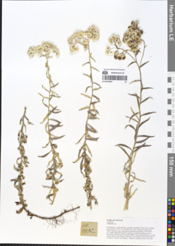
LE 01054664
Anaphalis margaritacea (L.) Benth. & Hook.f. det. Sennikov, Alexander Nikolaevitsch at 12.09.2019
Additional identifications: Gnaphalium sp. det. Averyanov, Leonid Vladimirovich at 20.10.2018 Collectors: Averyanov, Leonid Vladimirovich; Khang Sinh Nguyen; Maisak, Tatiana Viktorovna; Truong Duc Thieu Field collecting number: VR1092. Collection date: 20.10.2018. Administrative regions: VN - Tinh Ha Giang. Groups of specimens: L. V. Averyanov specimens; L. V. Averyanov herbarium; L. V. Averyanov photosOriginal label text:FLORA OF VIETNAM
Coordinates (geographic position): 23° 5′ 13.5″ N, 104° 48′ 30.2″ E ±1000 mComment: Asteraceae
Gnaphalium sp.
Ha Giang prov., Quan Ba distr., Cao Ma Po commune, Chin Chu Lin village, around point 23º05ʹ13.5ʺN 104º48ʹ30.2ʺE, rocky outcrops on steep rocky slopes composed with eroded karstic limestone at elevation 1750–1950 m a.s.l. Highly degraded remnants of primary evergreen broad-leaved very humid forest and evergreen secondary shrubs. Erect terrestrial herb to 1 m tall on open grassy slope. Flowers yellowish. Very common. 20 October 2018, L. Averyanov, Nguyen Sinh Khang, T. Maisak, Truong Duc Thieu, VR 1092.
All photos © L. Averyanov & K.S. Nguyen
Record creation: 2019-05-23, Leonid Averyanov, PhotoScan D1Citation: Specimen LE 01054664 // Virtual herbarium of Komarov Botanical Institute RAS — http://re.herbariumle.ru/01054664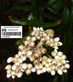
LE 01093189
Anaphalis margaritacea (L.) Benth. & Hook.f. det. Nuraliev, M. S., Sennikov, Alexander Nikolaevitsch
Collectors: Nuraliev, M. S. Field collecting number: NUR 214a. Collection date: 18.11.2010. Administrative regions: VN - Tinh Lao Cai. Original label text:Anaphalis margaritacea (L.) Benth. & Hook.f.
photo
NORTHERN VIETNAM
Lao Cai Prov., Sa Pa Distr., San Sa Ho municip.
Hoang Lien National Park, Tram Ton area
Forest, near trail to Fan Si Pan mt
elev. 2000-2200 m
Nuraliev M.S. NUR 214a18.11.2010
All photos © M. Nuraliev
Record creation: 2020-12-12, Nuraliev MaximCitation: Specimen LE 01093189 // Virtual herbarium of Komarov Botanical Institute RAS — http://re.herbariumle.ru/01093189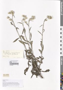
LE 01254261
Anaphalis margaritacea (L.) Benth. & Hook.f. det. Averyanov, Leonid Vladimirovich at 21.02.2024
Collectors: Averyanov, Leonid Vladimirovich; Nguyen Van Canh; Truong Ba Vuong; Maisak, Tatiana Viktorovna Field collecting number: AL2554. Collection date: 08.11.2023. Administrative regions: VN - Tinh Lam GJong. Groups of specimens: Образцы общего сектора; L. V. Averyanov specimens; L. V. Averyanov herbarium; Соглашение Минобрнауки №075-15-2021-1056; Flora of VietnamOriginal label text:FLORA OF VIETNAM
Asteraceae
Gnaphalium sp.
Lam Dong Province, Lac Duong District, Bidoup Nui Ba National Par, southern slopes of Bidoup Mountain about 5 km to the south from Bidoup peak around point 12º04.076’N 108º38.927E. Open grassy Pinus kesiya forest and woodlands at elevation about 1700–1900 m a.s.l. Erect terrestrial herb to 0.4 m tall. Very common.
08 November 2023, L. Averyanov, Nguyen Van Canh, Truong Ba Vuong, T. Maisak, AL2554.