View
Add
Copy
Edit
Delete
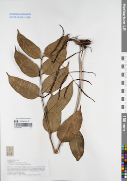
LE 01077709
Aglamorpha acuminata (Willd.) C.V.Morton det. Averyanov, Leonid Vladimirovich at 27.09.2016
Collectors: Averyanov, Leonid Vladimirovich; Tien Hiep Nguyen; Khang Sinh Nguyen; et al. Field collecting number: CPC8096. Collection date: 27.09.2016. Administrative regions: VN - Tinh Son La. Groups of specimens: L. V. Averyanov specimens; L. V. Averyanov herbarium; Соглашение Минобрнауки №075-15-2021-1056Original label text:FLORA OF VIETNAM
Polypodiaceae s.l.
Aglamorpha acuminata (Willd.) C.V.Morton
( = Photinopteris speciosa, Photinopteris acuminata)
Son La Prov., Moc Chau Distr., Chieng Son comm., about 1 km to NE from Chieng Son Village, around point 20°46′02.0N 104°37′03.1E.
Remnants of primary broad-leaved evergreen forest on tops of hills composed with karstic highly eroded yellow-white limestone at elevation 1150-1250 m a.s.l.
Creeping lithophytic fern on steep rocky slope near mountain top. Rare.
27 September 2016 CPC 8096 Photos
Coll.: L.Averyanov, N.T.Hiep, N.S.Khang, C.Q.Ngan, T.V.Maisak, N.T.Son.
Coordinates (geographic position): 20° 46′ 2″ N, 104° 37′ 3.1″ E ±1000 mRecord creation: 2021-12-02, Tatiana Maisak, PhotoScan D2Citation: Specimen LE 01077709 // Virtual herbarium of Komarov Botanical Institute RAS — http://re.herbariumle.ru/01077709Polypodiaceae s.l.
Aglamorpha acuminata (Willd.) C.V.Morton
( = Photinopteris speciosa, Photinopteris acuminata)
Son La Prov., Moc Chau Distr., Chieng Son comm., about 1 km to NE from Chieng Son Village, around point 20°46′02.0N 104°37′03.1E.
Remnants of primary broad-leaved evergreen forest on tops of hills composed with karstic highly eroded yellow-white limestone at elevation 1150-1250 m a.s.l.
Creeping lithophytic fern on steep rocky slope near mountain top. Rare.
27 September 2016 CPC 8096 Photos
Coll.: L.Averyanov, N.T.Hiep, N.S.Khang, C.Q.Ngan, T.V.Maisak, N.T.Son.
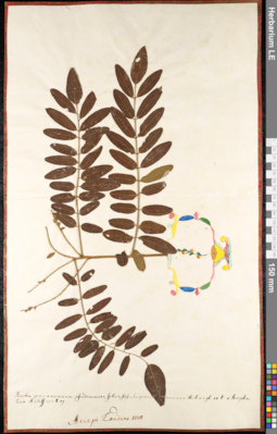
LE 01091103
Groups of specimens: Herbarium of Abraham EnsComment:
Amorpha 1135
Record creation: 2020-08-28, Andrey Sytin, PhotoScan D2Citation: Specimen LE 01091103 // Virtual herbarium of Komarov Botanical Institute RAS — http://re.herbariumle.ru/01091103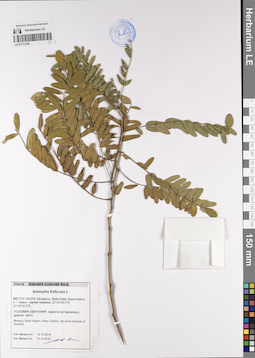
LE 01173195
Amorpha fruticosa L. det. Myalik A. M. at 10.10.2018
Collectors: Myalik A. M. Field collecting number: 2704/18. Collection date: 10.10.2018. Administrative regions: BY - Brest Oblast - Horad Brest. Groups of specimens: Образцы сектора Восточной Европы; Соглашение Минобрнауки №075-15-2021-1056; HERBARIUM ALIAKSANDR MIALIKOriginal label text:МЕСТО СБОРА: Беларусь, Брестская область, Брестский район, город Брест, южная окраина, 52°02'45.0''N 23°44'35.5''E
УСЛОВИЯ ОБИТАНИЯ: заросли кустарников у дороги, часто.
Belarus, Brest Region, Stolin district, sity Brest (thickets of bushes)
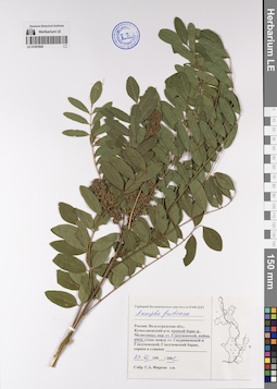
LE 01201626
Amorpha fruticosa L. det. Firsov, Gennadij Afanasievich at 27.07.2001
Collectors: Firsov, Gennadij Afanasievich Collection date: 27.07.2001. Administrative regions: RU - Volgogradskaya Oblast' - Kumylzhenskiy Rayon. Groups of specimens: Образцы сектора Восточной Европы; Соглашение Минобрнауки №075-15-2021-1056Original label text:Россия: Волгоградская область, Нижнехоперский природный парк, Кумылженский район, правый берег реки Медведицы, окрестности станицы Глазуновской, пойма реки.
Coordinates (geographic position): 49° 47′ 27.99″ N, 42° 50′ 56.65″ E ±1000 mRecord creation: 2023-01-19, Denis Melnikov, PhotoScan D2.Citation: Specimen LE 01201626 // Virtual herbarium of Komarov Botanical Institute RAS — http://re.herbariumle.ru/01201626