View
Add
Copy
Edit
Delete
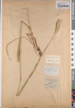
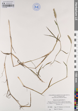
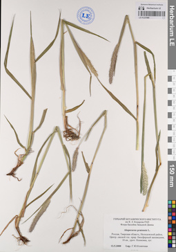
LE 01237561
Alopecurus arundinaceus Poir. at 1903
Collectors: illegible Groups of specimens: Образцы сектора Восточной Европы; Соглашение Минобрнауки №075-15-2021-1056Original label text:(нечитаемый текст)
Record creation: 2023-05-16, Artyom Borodushkin, PhotoScan D2. Part 1.. Processing status: label contains unreadable dataCitation: Specimen LE 01237561 // Virtual herbarium of Komarov Botanical Institute RAS — http://re.herbariumle.ru/01237561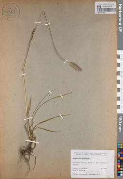
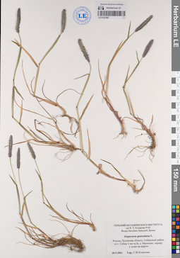
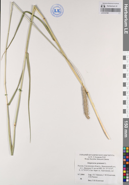
LE 01237562
Alopecurus pratensis L. det. Bobrov, A.
Collectors: Gorodkov K. B. Collection date: 28.07.1949. Administrative regions: RU-Komi - Vorkuta (gorodskoj okrug). Groups of specimens: Образцы сектора Восточной Европы; Соглашение Минобрнауки №075-15-2021-1056Original label text:ВОРКУТА. Долина ручья в 1 километре к северу от города
Record creation: 2023-05-16, Artyom Borodushkin, PhotoScan D2. Part 1.Citation: Specimen LE 01237562 // Virtual herbarium of Komarov Botanical Institute RAS — http://re.herbariumle.ru/01237562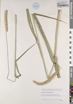
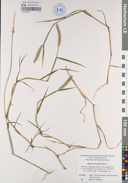
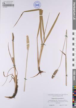
LE 01237563
Alopecurus arundinaceus Poir.
Collectors: Efimov, Peter Gennadievich; Konechnaya, Galina Yurievna; Kuropatkin Vladislav Collection date: 09.07.2012. Administrative regions: RU - Vologodskaya Oblast' - Kirillovskiy Rayon. Groups of specimens: Образцы сектора Восточной Европы; Соглашение Минобрнауки №075-15-2021-1056Original label text:Вологодская область, Кирилловский район, город Кириллов, в канаве в центральной части города
Record creation: 2023-05-16, Artyom Borodushkin, PhotoScan D2. Part 1.Citation: Specimen LE 01237563 // Virtual herbarium of Komarov Botanical Institute RAS — http://re.herbariumle.ru/01237563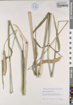
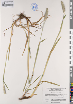
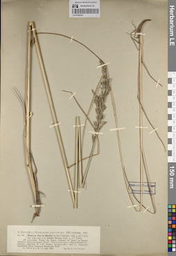
LE 01237564
Alopecurus arundinaceus Poir.
Collectors: Efimov, Peter Gennadievich; Konechnaya, Galina Yurievna; Kuropatkin Vladislav Collection date: 09.07.2012. Administrative regions: RU - Vologodskaya Oblast' - Kirillovskiy Rayon. Groups of specimens: Образцы сектора Восточной Европы; Соглашение Минобрнауки №075-15-2021-1056Original label text:Вологодская область, Кирилловский район, город Кириллов, в канаве в центральной части города
Record creation: 2023-05-16, Artyom Borodushkin, PhotoScan D2. Part 1.Citation: Specimen LE 01237564 // Virtual herbarium of Komarov Botanical Institute RAS — http://re.herbariumle.ru/01237564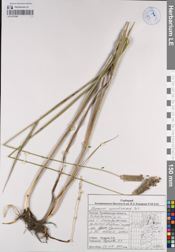
LE 01237565
Alopecurus arundinaceus Poir. det. Rjazanova, Lydia Vasilievna
Collectors: Rjazanova, Lydia Vasilievna Collection date: 06.07.1994. Administrative regions: RU - Chelyabinskaya Oblast' - Oktyabr'skiy Rayon. Groups of specimens: Образцы сектора Восточной Европы; Соглашение Минобрнауки №075-15-2021-1056Original label text:Россия, Челябинская область, Октябрьский район, окрестности села Каракульское солонцеватый сырой луг в долине реки Уй. обычен, много
Record creation: 2023-05-16, Artyom Borodushkin, PhotoScan D2. Part 1.Citation: Specimen LE 01237565 // Virtual herbarium of Komarov Botanical Institute RAS — http://re.herbariumle.ru/01237565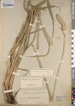
LE 01237589
Alopecurus ruthenicus Weinm. det. Ganeschin, Sergej Sergejewitsch
Collectors: Alexeenko, Fyodor Nikitich Collection date: 17.05.1895. Administrative regions: UA - Dnipropetrovska Oblast' - Dnipro Raion. Groups of specimens: Образцы сектора Восточной Европы; Соглашение Минобрнауки №075-15-2021-1056Original label text:Екатеринослав. Технический сад
Record creation: 2023-05-16, Artyom Borodushkin, PhotoScan D2. Part 1.Citation: Specimen LE 01237589 // Virtual herbarium of Komarov Botanical Institute RAS — http://re.herbariumle.ru/01237589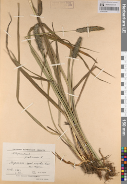
LE 01237591
Alopecurus pratensis L. det. Gusev, Yuriy Dmitrievich
Collectors: Gusev, Yuriy Dmitrievich Field collecting number: 55. Collection date: 27.07.1968. Administrative regions: RU - Murmanskaya Oblast'. Groups of specimens: Образцы сектора Восточной Европы; Соглашение Минобрнауки №075-15-2021-1056Original label text:Мурманск, край канавы возле железной дороги.
Record creation: 2023-05-16, Artyom Borodushkin, PhotoScan D2. Part 1.Citation: Specimen LE 01237591 // Virtual herbarium of Komarov Botanical Institute RAS — http://re.herbariumle.ru/01237591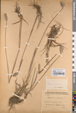
LE 01237592
Alopecurus pratensis L. det. Roshevitz, Roman Julievich at 01.1922
Collectors: Savich, N. Field collecting number: 268. Collection date: 08.07.1921. Administrative regions: RU - Murmanskaya Oblast' - Kol'skiy Rayon. Groups of specimens: Образцы сектора Восточной Европы; Соглашение Минобрнауки №075-15-2021-1056Original label text:Мурманская губерния Окрестности города Колы. Кольская губа. Песчаный берег.
Record creation: 2023-05-16, Artyom Borodushkin, PhotoScan D2. Part 1.Citation: Specimen LE 01237592 // Virtual herbarium of Komarov Botanical Institute RAS — http://re.herbariumle.ru/01237592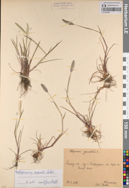
LE 01237593
Alopecurus aequalis Sobol. det. Gnutikov, Alexander Alexandrovich at 11.2013
Collectors: Kamelin, Rudolph Vladimirovich Collection date: 28.06.1968. Administrative regions: RU - Sankt-Peterburg - Kurortnyy Rayon. Groups of specimens: Образцы сектора Восточной Европы; Соглашение Минобрнауки №075-15-2021-1056Original label text:Ленинградская область, окрестности города Сестрорецка, западный берег озера Разлив, пески
Record creation: 2023-05-16, Artyom Borodushkin, PhotoScan D2. Part 1.Citation: Specimen LE 01237593 // Virtual herbarium of Komarov Botanical Institute RAS — http://re.herbariumle.ru/01237593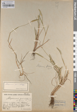
LE 01237594
Alopecurus geniculatus L. det. Ganeschin, Sergej Sergejewitsch
Collectors: Dingelschtedt, F. Collection date: 02.08.1913. Administrative regions: RU - Russian Federation. Groups of specimens: Образцы сектора Восточной Европы; Соглашение Минобрнауки №075-15-2021-1056Original label text:Олонецкая губерния Бассейн реки Свири. Мокрый луг по прибрежной аллювиальной полосе левого берега Свири, близ Александро-Невской пристани.
Record creation: 2023-05-16, Artyom Borodushkin, PhotoScan D2. Part 1.Citation: Specimen LE 01237594 // Virtual herbarium of Komarov Botanical Institute RAS — http://re.herbariumle.ru/01237594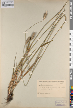
LE 01237595
Alopecurus pratensis L.
Administrative regions: UA - Dnipropetrovska Oblast' - Dnipro Raion. Groups of specimens: Образцы сектора Восточной Европы; Соглашение Минобрнауки №075-15-2021-1056Original label text:In hortis, insulis Borysthenis fluv... apud Katerinoslav urbem. (В саду на острове на реке Днепр в городе Екатеринославе.)
Record creation: 2023-05-16, Artyom Borodushkin, PhotoScan D2. Part 1.Citation: Specimen LE 01237595 // Virtual herbarium of Komarov Botanical Institute RAS — http://re.herbariumle.ru/01237595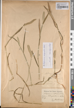
LE 01237596
Alopecurus aequalis Sobol. det. Gnutikov, Alexander Alexandrovich at 11.2013
Collectors: Rostovtsev Administrative regions: RU - Russian Federation. Groups of specimens: Образцы сектора Восточной Европы; Соглашение Минобрнауки №075-15-2021-1056Original label text:Gubernium Petropolitana, Districtum Luga. (Лужский уезд Санкт-Петербургской губернии.)
Record creation: 2023-05-16, Artyom Borodushkin, PhotoScan D2. Part 1.Citation: Specimen LE 01237596 // Virtual herbarium of Komarov Botanical Institute RAS — http://re.herbariumle.ru/01237596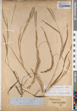
LE 01237597
Alopecurus aequalis Sobol. det. Gnutikov, Alexander Alexandrovich at 11.2013
Groups of specimens: Образцы сектора Восточной Европы; Соглашение Минобрнауки №075-15-2021-1056Original label text:(нечитаемый текст)
Record creation: 2023-05-16, Artyom Borodushkin, PhotoScan D2. Part 1.Citation: Specimen LE 01237597 // Virtual herbarium of Komarov Botanical Institute RAS — http://re.herbariumle.ru/01237597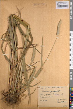
LE 01237679
Alopecurus pratensis L. det. Tzvelev, Nikolai Nikolaievich
Collectors: Unknown Field collecting number: 223. Collection date: 26.06.1910. Administrative regions: RU - Respublika Sakha (Yakutiya) - Lenskiy Rayon. Groups of specimens: Образцы сектора Восточной Европы; Соглашение Минобрнауки №075-15-2021-1056Original label text:Лена у устьев Витима , луг Якутская область
Record creation: 2023-05-16, Artyom Borodushkin, PhotoScan D2. Part 2.Citation: Specimen LE 01237679 // Virtual herbarium of Komarov Botanical Institute RAS — http://re.herbariumle.ru/01237679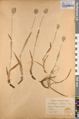
LE 01237680
Alopecurus stejnegeri Vasey det. Komarov, Vladimir Leontjevich
Collectors: Novograblenov, Prokopiy Trifonovich Field collecting number: 1014. Collection date: 22.07.1929. Administrative regions: RU - Kamtchatski Kray. Groups of specimens: Образцы сектора Восточной Европы; Соглашение Минобрнауки №075-15-2021-1056Original label text:Камчатка река Анаун, гора Кергечан h=1000 м
Coordinates (geographic position): 1000 m a.s.l.Record creation: 2023-05-16, Artyom Borodushkin, PhotoScan D2. Part 2.Citation: Specimen LE 01237680 // Virtual herbarium of Komarov Botanical Institute RAS — http://re.herbariumle.ru/01237680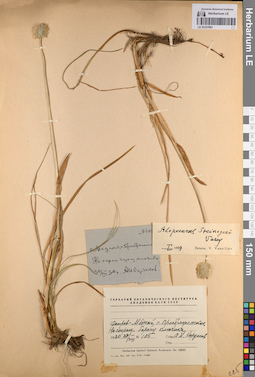
LE 01237681
Alopecurus stejnegeri Vasey det. Vassiljev, V. at 01.1959
Collectors: Kardakov A. N. Field collecting number: 105. Collection date: 30.08.1930. Administrative regions: RU - Kamtchatski Kray - Aleutskiy Rayon. Groups of specimens: Образцы сектора Восточной Европы; Соглашение Минобрнауки №075-15-2021-1056Original label text:Остров Медный, село Преображенское На сыром берегу ключика
Record creation: 2023-05-16, Artyom Borodushkin, PhotoScan D2. Part 2.Citation: Specimen LE 01237681 // Virtual herbarium of Komarov Botanical Institute RAS — http://re.herbariumle.ru/01237681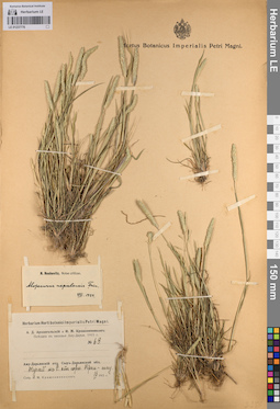
LE 01237776
Alopecurus nepalensis Trin. ex Steud. det. Roshevitz, Roman Julievich at 08.1939
Collectors: Krascheninnikov, Ippolit (Hippolit) Mikhailovich Field collecting number: 63. Collection date: 16.04.1915. Groups of specimens: Образцы сектора Восточной Европы; Соглашение Минобрнауки №075-15-2021-1056Original label text:Аму-Дарьинский (Амударьинский) отдел Сыр-Дарьинской (Сырдарьинской) области Тугай к северу от горы Кран-тау.
Record creation: 2023-05-16, Artyom Borodushkin, PhotoScan D2. Part 2.Citation: Specimen LE 01237776 // Virtual herbarium of Komarov Botanical Institute RAS — http://re.herbariumle.ru/01237776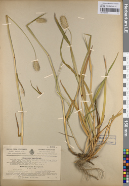
LE 01237777
Alopecurus laguriformis Schur det. Unknown
Collectors: Unknown Collection date: 23.07.1910. Administrative regions: RO - Judetul Brasov. Groups of specimens: Образцы сектора Восточной Европы; Соглашение Минобрнауки №075-15-2021-1056Original label text:Alpes Fogarasenses. In lapidosis herbosis ad lacum Bullea. Sol. schist., in alt. c. 2000 m. (Озеро Балеа)
Record creation: 2023-05-16, Artyom Borodushkin, PhotoScan D2. Part 2.Citation: Specimen LE 01237777 // Virtual herbarium of Komarov Botanical Institute RAS — http://re.herbariumle.ru/01237777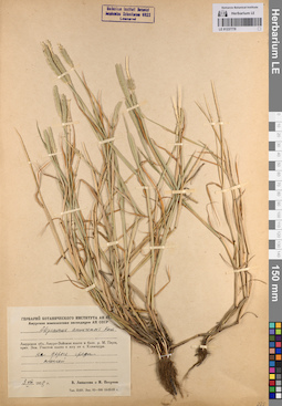
LE 01237778
Alopecurus amurensis Kom.
Collectors: Lipatova, V.; Unknown Collection date: 03.08.1958. Administrative regions: RU - Amurskaya Oblast' - Svobodnenskiy Rayon. Groups of specimens: Образцы сектора Восточной Европы; Соглашение Минобрнауки №075-15-2021-1056Original label text:Амурская область Амуро-Зейское плато в бассейне реки Малой Перы, притока Зеи. Участок плато к югу от села Климоуцы. На дороге среди полей
Record creation: 2023-05-16, Artyom Borodushkin, PhotoScan D2. Part 2.Citation: Specimen LE 01237778 // Virtual herbarium of Komarov Botanical Institute RAS — http://re.herbariumle.ru/01237778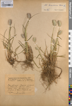
LE 01237779
Alopecurus himalaicus Hook. f. at 12.1955
Collectors: Nepli, Georgy Nikolaevich Collection date: 17.07.1942. Groups of specimens: Образцы сектора Восточной Европы; Соглашение Минобрнауки №075-15-2021-1056Original label text:Западный Памир. Верхнее течение реки Туссион. Сай на левом берегу реки. Каменистые россыпи у озера в верховье сая.
Record creation: 2023-05-16, Artyom Borodushkin, PhotoScan D2. Part 2.Citation: Specimen LE 01237779 // Virtual herbarium of Komarov Botanical Institute RAS — http://re.herbariumle.ru/01237779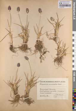
LE 01237780
Alopecurus mucronatus Hack. det. Nepli, Georgy Nikolaevich
Collectors: Nepli, Georgy Nikolaevich Field collecting number: 20. Collection date: 28.06.1942. Groups of specimens: Образцы сектора Восточной Европы; Соглашение Минобрнауки №075-15-2021-1056Original label text:Восточный Памир. Алигурская долина. У реки близ моста.
Record creation: 2023-05-16, Artyom Borodushkin, PhotoScan D2. Part 2.Citation: Specimen LE 01237780 // Virtual herbarium of Komarov Botanical Institute RAS — http://re.herbariumle.ru/01237780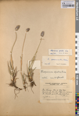
LE 01237781
Alopecurus apiatus Ovcz. det. Nabiev, M.M. at 30.11.1964
Collectors: Nepli, Georgy Nikolaevich Collection date: 04.09.1943. Groups of specimens: Образцы сектора Восточной Европы; Соглашение Минобрнауки №075-15-2021-1056Original label text:Западный Памир. (нечитаемо) реке Шах-дарье (Шахдарье). Долина ручья (нечитаемо)-бай в верхнем течении. Ассоциация осоково-злаково-разнотравная.
Record creation: 2023-05-16, Artyom Borodushkin, PhotoScan D2. Part 2.. Processing status: label contains unreadable dataCitation: Specimen LE 01237781 // Virtual herbarium of Komarov Botanical Institute RAS — http://re.herbariumle.ru/01237781
LE 01237783
Alopecurus aucheri Boiss. det. Tzvelev, Nikolai Nikolaievich
Collectors: Tzvelev, Nikolai Nikolaievich; Czerepanov, Sergei Kirillovich Field collecting number: 426. Collection date: 27.06.1960. Administrative regions: AM - Armenia. Groups of specimens: Образцы сектора Восточной Европы; Соглашение Минобрнауки №075-15-2021-1056Original label text:Армянская ССР. Гукасянский район. Предгорья Джавахетского хребта к востоку от села Гукасян. Каменистый луговой склон. Высота над уровнем моря примерно 2100 метров
Coordinates (geographic position): 2100 m a.s.l.Record creation: 2023-05-16, Artyom Borodushkin, PhotoScan D2. Part 2.Citation: Specimen LE 01237783 // Virtual herbarium of Komarov Botanical Institute RAS — http://re.herbariumle.ru/01237783
LE 01237784
Alopecurus armenus (K. Koch) Grossh. det. Tzvelev, Nikolai Nikolaievich
Collectors: Tzvelev, Nikolai Nikolaievich; Czerepanov, Sergei Kirillovich Field collecting number: 424. Collection date: 27.06.1960. Administrative regions: AM - Armenia. Groups of specimens: Образцы сектора Восточной Европы; Соглашение Минобрнауки №075-15-2021-1056Original label text:Армянская ССР. Гукасянский район. Предгорья Джавахетского хребта к востоку от села Гукасян. Влажный луг у берега реки Гукасян. Высота над уровнем моря примерно 1800 метров
Coordinates (geographic position): 1800 m a.s.l.Record creation: 2023-05-16, Artyom Borodushkin, PhotoScan D2. Part 2.Citation: Specimen LE 01237784 // Virtual herbarium of Komarov Botanical Institute RAS — http://re.herbariumle.ru/01237784
LE 01237785
Alopecurus glacialis K. Koch det. illegible, Unknown
Collectors: illegible; Unknown Collection date: 13.07.1940. Groups of specimens: Образцы сектора Восточной Европы; Соглашение Минобрнауки №075-15-2021-1056Original label text:Юго-Осетия. Эрмени. Конус выноса Оридар-кок. Высота 2200 метров
Coordinates (geographic position): 2200 m a.s.l.Record creation: 2023-05-16, Artyom Borodushkin, PhotoScan D2. Part 2.Citation: Specimen LE 01237785 // Virtual herbarium of Komarov Botanical Institute RAS — http://re.herbariumle.ru/01237785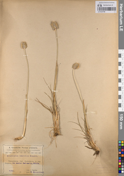
LE 01237786
Alopecurus textilis Boiss. det. Grossheim, Alexander Alfonsovich
Collectors: Gavrilov, I. Collection date: 07.06.1928. Administrative regions: AZ - Nakhchivan Autonomous Republic. Groups of specimens: Образцы сектора Восточной Европы; Соглашение Минобрнауки №075-15-2021-1056Original label text:Transcaucasia, districtum Nachitshevan, in jugo Zangezur, in monte Salvarty, 3000 m. - Закавказье, Нахичеванский район, возле Зангезура, на горе Салварты, 3000 метров.
Coordinates (geographic position): 3000 m a.s.l.Record creation: 2023-05-16, Artyom Borodushkin, PhotoScan D2. Part 2.Citation: Specimen LE 01237786 // Virtual herbarium of Komarov Botanical Institute RAS — http://re.herbariumle.ru/01237786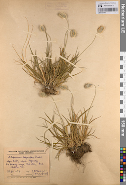
LE 01237787
Alopecurus dasyanthus Trautv.
Collectors: Vysokoostrovskaja, I. B. Collection date: 22.08.1947. Administrative regions: AM - Armenia. Groups of specimens: Образцы сектора Восточной Европы; Соглашение Минобрнауки №075-15-2021-1056Original label text:Армянская ССР, гора Арагау На берегу озера Сев-Лиг, высота 3200 метров над уровнем моря.
Coordinates (geographic position): 3200 m a.s.l.Record creation: 2023-05-16, Artyom Borodushkin, PhotoScan D2. Part 2.Citation: Specimen LE 01237787 // Virtual herbarium of Komarov Botanical Institute RAS — http://re.herbariumle.ru/01237787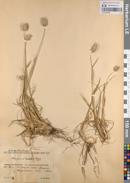
LE 01237788
Alopecurus sp.
Collectors: Busch, Elizaveta Aleksandrovna; Busch, Nicolai Adolfowitsch (Nikolaj Adolfovich) Administrative regions: AM - Armenia. Groups of specimens: Образцы сектора Восточной Европы; Соглашение Минобрнауки №075-15-2021-1056Original label text:Эрман 2600 метров. На северном склоне Фарака Rhododendron 2600-2700 метров
Coordinates (geographic position): 2600 m a.s.l.Record creation: 2023-05-16, Artyom Borodushkin, PhotoScan D2. Part 2.Citation: Specimen LE 01237788 // Virtual herbarium of Komarov Botanical Institute RAS — http://re.herbariumle.ru/01237788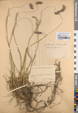
LE 01237789
Alopecurus aucheri Boiss.
Collectors: Fedtschenko, Olga Alexandrowna; Fedtschenko, Boris Alexjewitsch Field collecting number: 12. Collection date: 27.06.1894. Groups of specimens: Образцы сектора Восточной Европы; Соглашение Минобрнауки №075-15-2021-1056Original label text:Северный Кавказ Ледник (нечитаемо).
Record creation: 2023-05-16, Artyom Borodushkin, PhotoScan D2. Part 2.. Processing status: label contains unreadable dataCitation: Specimen LE 01237789 // Virtual herbarium of Komarov Botanical Institute RAS — http://re.herbariumle.ru/01237789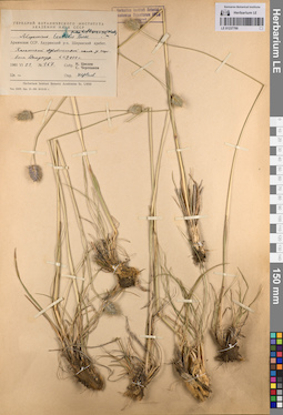
LE 01237790
Alopecurus textilis Boiss. det. Tzvelev, Nikolai Nikolaievich
Collectors: Tzvelev, Nikolai Nikolaievich; Czerepanov, Sergei Kirillovich Field collecting number: 167. Collection date: 23.06.1960. Administrative regions: AM - Shiraki Marz. Groups of specimens: Образцы сектора Восточной Европы; Соглашение Минобрнауки №075-15-2021-1056Original label text:Армянская ССР, Ахурянский район Ширакский хребет, Каменистый луговостепной склон у перевала Джунгур. высота 2000 метров
Coordinates (geographic position): 2000 m a.s.l.Record creation: 2023-05-16, Artyom Borodushkin, PhotoScan D2. Part 2.Citation: Specimen LE 01237790 // Virtual herbarium of Komarov Botanical Institute RAS — http://re.herbariumle.ru/01237790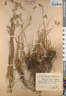
LE 01237791
Alopecurus sericeus Albov det. Tzvelev, Nikolai Nikolaievich
Collectors: Vassiljev, I. V. Collection date: 15.07.1951. Administrative regions: RU - Russian Federation. Groups of specimens: Образцы сектора Восточной Европы; Соглашение Минобрнауки №075-15-2021-1056Original label text:Подножье горы Оштен. Травянисто-каменистый склон. 2000 метров
Coordinates (geographic position): 2000 m a.s.l.Record creation: 2023-05-16, Artyom Borodushkin, PhotoScan D2. Part 2.Citation: Specimen LE 01237791 // Virtual herbarium of Komarov Botanical Institute RAS — http://re.herbariumle.ru/01237791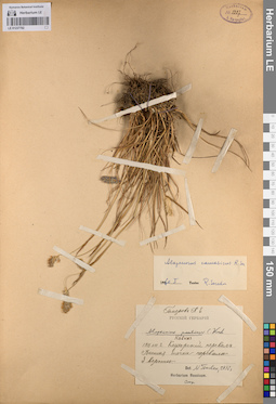
LE 01237792
Alopecurus penticus C. Kuh det. illegible at 1992
Collectors: Gomerov, K.E. Groups of specimens: Образцы сектора Восточной Европы; Соглашение Минобрнауки №075-15-2021-1056Original label text:Клухорский перевал. Высшая точка перевала 3 версты.
Coordinates (geographic position): 3200 m a.s.l.Record creation: 2023-05-16, Artyom Borodushkin, PhotoScan D2. Part 2.Citation: Specimen LE 01237792 // Virtual herbarium of Komarov Botanical Institute RAS — http://re.herbariumle.ru/01237792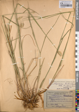
LE 01237793
Alopecurus roshevitzianus Ovcz. det. Karavaev, Mikhail Nikolaevich
Collectors: Karavaev, Mikhail Nikolaevich Collection date: 16.07.1948. Administrative regions: RU - Respublika Sakha (Yakutiya). Groups of specimens: Образцы сектора Восточной Европы; Соглашение Минобрнауки №075-15-2021-1056Original label text:Чурапчинский район Прирусловой сырой луг вдоль реки Дойга в 15 километрах от города Мондигай
Record creation: 2023-05-16, Artyom Borodushkin, PhotoScan D2. Part 2.Citation: Specimen LE 01237793 // Virtual herbarium of Komarov Botanical Institute RAS — http://re.herbariumle.ru/01237793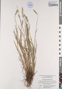
LE 01237982
Alopecurus aequalis Sobol. det. Konechnaya, Galina Yurievna at 12.07.2004
Collectors: Buzunova, Irina Olegovna; Efimov, Peter Gennadievich; Konechnaya, Galina Yurievna; Raenko, Larisa Mikhailovna Collection date: 12.07.2004. Administrative regions: RU - Smolenskaya Oblast' - Velizhskiy Rayon. Groups of specimens: Образцы сектора Восточной Европы; Соглашение Минобрнауки №075-15-2021-1056Original label text:ГЕРБАРИЙ БОТАНИЧЕСКОГО ИНСТИТУТА
им В. Л. Комарова РАН
Флора бассейна западной Двины
Alopecurus aequalis Sobol.
Россия, Смоленская область, Велижский р-н, от г. Велиж 9 км на 3, (N: 55°37'37"; E: 31°1'22") между д. Будница и д. Замошье, у поворота к д. Пушка, обочина шоссе.
12.7.2004
Leg.: И.О.Бузунова, П.Г.Ефимов, Г.Ю. Конечная, Л.М.Раенко
N
Det.:Г.Ю.Конечная
Coordinates (geographic position): 55° 37′ 36.98″ N, 31° 1′ 22.01″ ERecord creation: 2023-05-18, Artyom Borodushkin, PhotoScan D2.Citation: Specimen LE 01237982 // Virtual herbarium of Komarov Botanical Institute RAS — http://re.herbariumle.ru/01237982им В. Л. Комарова РАН
Флора бассейна западной Двины
Alopecurus aequalis Sobol.
Россия, Смоленская область, Велижский р-н, от г. Велиж 9 км на 3, (N: 55°37'37"; E: 31°1'22") между д. Будница и д. Замошье, у поворота к д. Пушка, обочина шоссе.
12.7.2004
Leg.: И.О.Бузунова, П.Г.Ефимов, Г.Ю. Конечная, Л.М.Раенко
N
Det.:Г.Ю.Конечная
LE 01237983
Alopecurus geniculatus L. det. Konechnaya, Galina Yurievna at 16.07.2001
Collectors: Konechnaya, Galina Yurievna Collection date: 16.07.2001. Administrative regions: RU - Pskovskaya Oblast' - Sebezhskiy Rayon. Groups of specimens: Образцы сектора Восточной Европы; Соглашение Минобрнауки №075-15-2021-1056Original label text:ГЕРБАРИЙ БОТАНИЧЕСКОГО ИНСТИТУТА
им В. Л. Комарова РАН
Флора бассейна Западной Двины
Alopecurus geniculatus L.
Россия, Псковская область, Себежский район, Национальный парк «Себежский», от г. Себеж 19 км на ЮВ, окр. д. Осыно, луг.
16.7.2001
Leg.: Г.Ю. Конечная
Coordinates (geographic position): 56° 9′ 19.73″ N, 28° 39′ 55.28″ E ±100 mRecord creation: 2023-05-18, Artyom Borodushkin, PhotoScan D2.Citation: Specimen LE 01237983 // Virtual herbarium of Komarov Botanical Institute RAS — http://re.herbariumle.ru/01237983им В. Л. Комарова РАН
Флора бассейна Западной Двины
Alopecurus geniculatus L.
Россия, Псковская область, Себежский район, Национальный парк «Себежский», от г. Себеж 19 км на ЮВ, окр. д. Осыно, луг.
16.7.2001
Leg.: Г.Ю. Конечная
LE 01237984
Alopecurus geniculatus L. det. Konechnaya, Galina Yurievna at 03.06.2004
Collectors: Konechnaya, Galina Yurievna Collection date: 03.06.2004. Administrative regions: RU - Pskovskaya Oblast' - Sebezhskiy Rayon. Groups of specimens: Образцы сектора Восточной Европы; Соглашение Минобрнауки №075-15-2021-1056Original label text:ГЕРБАРИЙ БОТАНИЧЕСКОГО ИНСТИТУТА
им В. Л. Комарова РАН Флора бассейна Западной Двины
Alopecurus geniculatus L.
Россия, Псковская область, Себежский район, Национальный парк «Себежский», от г. Себеж 19 км на ЮВ. Дер. Осыно, сырой проезд на залежи.
3.6.2004
Leg.: Г.Ю.Конечная
Coordinates (geographic position): 56° 9′ 19.45″ N, 28° 39′ 56.3″ E ±1000 mRecord creation: 2023-05-18, Artyom Borodushkin, PhotoScan D2.Citation: Specimen LE 01237984 // Virtual herbarium of Komarov Botanical Institute RAS — http://re.herbariumle.ru/01237984им В. Л. Комарова РАН Флора бассейна Западной Двины
Alopecurus geniculatus L.
Россия, Псковская область, Себежский район, Национальный парк «Себежский», от г. Себеж 19 км на ЮВ. Дер. Осыно, сырой проезд на залежи.
3.6.2004
Leg.: Г.Ю.Конечная
LE 01237985
Alopecurus geniculatus L. det. Konechnaya, Galina Yurievna at 29.07.2002
Collectors: Dorofeev, Vladimir Ivanovich; Illarionova, Irina Dmitrievna; Konechnaya, Galina Yurievna Collection date: 29.07.2002. Administrative regions: RU - Pskovskaya Oblast' - Usvyatskiy Rayon. Groups of specimens: Образцы сектора Восточной Европы; Соглашение Минобрнауки №075-15-2021-1056Original label text:ГЕРБАРИЙ БОТАНИЧЕСКОГО ИНСТИТУТА им В. Л. Комарова РАН Флора бассейна Западной Двины
Alopecurus geniculatus L.
Россия, Псковская область, Усвятский район, от пос. Усвяты 23 км на СВ, с. Адамово, р. Усвяча.
29.7.2002
Det.:П.Г.Ефимов
Coordinates (geographic position): 55° 56′ 28.13″ N, 30° 53′ 22.32″ E ±100 mRecord creation: 2023-05-18, Artyom Borodushkin, PhotoScan D2.Citation: Specimen LE 01237985 // Virtual herbarium of Komarov Botanical Institute RAS — http://re.herbariumle.ru/01237985Alopecurus geniculatus L.
Россия, Псковская область, Усвятский район, от пос. Усвяты 23 км на СВ, с. Адамово, р. Усвяча.
29.7.2002
Leg.: В.И.Дорофеев, И.Д. Илларионова, Г.Ю.Конечная
Det.:П.Г.Ефимов
LE 01237986
Alopecurus geniculatus L. det. Efimov, Peter Gennadievich at 18.07.2003
Collectors: Efimov, Peter Gennadievich; Svetlova Alyena Collection date: 18.07.2003. Administrative regions: RU - Sakhalinskaya Oblast' - Nevel'skiy Rayon. Groups of specimens: Образцы сектора Восточной Европы; Соглашение Минобрнауки №075-15-2021-1056Original label text:ГЕРБАРИЙ БОТАНИЧЕСКОГО ИНСТИТУТА Флора бассейна Западной Двины
им В. Л. Комарова РАН
Alopecurus geniculatus L.
Россия, Псковская область, Невельский район, от г. Невель 14 км на 3. (N: 56°09"; E: 29°41'59") Д. Липовки, луг.
18.7.2003
Leg.: П.Г.Ефимов, А.А.Светлова
N
Det.: П.Г.Ефимов
Coordinates (geographic position): 56° 9′ 0″ N, 29° 41′ 58.99″ ERecord creation: 2023-05-18, Artyom Borodushkin, PhotoScan D2.Citation: Specimen LE 01237986 // Virtual herbarium of Komarov Botanical Institute RAS — http://re.herbariumle.ru/01237986им В. Л. Комарова РАН
Alopecurus geniculatus L.
Россия, Псковская область, Невельский район, от г. Невель 14 км на 3. (N: 56°09"; E: 29°41'59") Д. Липовки, луг.
18.7.2003
Leg.: П.Г.Ефимов, А.А.Светлова
N
Det.: П.Г.Ефимов
LE 01237987
Collectors: Konechnaya, Galina Yurievna Collection date: 20.05.2001. Administrative regions: RU - Pskovskaya Oblast' - Sebezhskiy Rayon. Groups of specimens: Образцы сектора Восточной Европы; Соглашение Минобрнауки №075-15-2021-1056Original label text:
ГЕРБАРИЙ БОТАНИЧЕСКОГО ИНСТИТУТА им В. Л. Комарова РАН Флора бассейна Западной Двины
Alopecurus geniculatus L.
Россия, Псковская область, Себежский район, от г. Себеж 6 км на В, д. Мальково, карьер, у лужи на дороге
20.5.2001
Leg.: ГЮ. Конечная
Coordinates (geographic position): 56° 17′ 29.05″ N, 28° 36′ 4.87″ E ±100 mRecord creation: 2023-05-18, Artyom Borodushkin, PhotoScan D2.Citation: Specimen LE 01237987 // Virtual herbarium of Komarov Botanical Institute RAS — http://re.herbariumle.ru/01237987Alopecurus geniculatus L.
Россия, Псковская область, Себежский район, от г. Себеж 6 км на В, д. Мальково, карьер, у лужи на дороге
20.5.2001
Leg.: ГЮ. Конечная
LE 01237988
Alopecurus geniculatus L. det. Efimov, Peter Gennadievich at 04.08.2004
Collectors: Konechnaya, Galina Yurievna; Krupkina, Lyudmila Ivanovna; Svetlova Alyena Collection date: 04.08.2004. Administrative regions: RU - Tverskaya Oblast'. Groups of specimens: Образцы сектора Восточной Европы; Соглашение Минобрнауки №075-15-2021-1056Original label text:ГЕРБАРИЙ БОТАНИЧЕСКОГО ИНСТИТУТА
им В. Л. Комарова РАН Флора бассейна Западной Двины
Alopecurus geniculatus L.
Россия, Тверская область, Бельский р-н, от пос. Белый 12 км на СВ. (N: 55°56′22"; Е: 33°2'34") Окр. д. Нестерово, луг.
4.8.2004
Leg.: Г.Ю.Конечная, Л.И.Крупкина,
А.А.Светлова
Det.:П.Г.Ефимов
Coordinates (geographic position): 55° 56′ 21.98″ N, 33° 2′ 34.01″ ERecord creation: 2023-05-18, Artyom Borodushkin, PhotoScan D2.Citation: Specimen LE 01237988 // Virtual herbarium of Komarov Botanical Institute RAS — http://re.herbariumle.ru/01237988им В. Л. Комарова РАН Флора бассейна Западной Двины
Alopecurus geniculatus L.
Россия, Тверская область, Бельский р-н, от пос. Белый 12 км на СВ. (N: 55°56′22"; Е: 33°2'34") Окр. д. Нестерово, луг.
4.8.2004
Leg.: Г.Ю.Конечная, Л.И.Крупкина,
А.А.Светлова
Det.:П.Г.Ефимов
LE 01237989
Alopecurus pratensis L. det. Konechnaya, Galina Yurievna at 11.05.2004
Collectors: Geltman, Dmitri Victorovich; Efimov, Peter Gennadievich; Illarionova, Irina Dmitrievna; Konechnaya, Galina Yurievna Collection date: 11.05.2004. Administrative regions: RU - Smolenskaya Oblast'. Groups of specimens: Образцы сектора Восточной Европы; Соглашение Минобрнауки №075-15-2021-1056Original label text:ГЕРБАРИЙ БОТАНИЧЕСКОГО ИНСТИТУТА им В. Л. Комарова РАН Флора бассейна Западной Двины
Alopecurus pratensis L.
Россия, Смоленская область, от г. Велиж 3 км на ЮЗ. (N: 55°35'1"; E: 31°6'59") Берег Зап. Двины напротив д. Нижнее Красное, луг.
11.5.2004
Leg.: Д.В.Гельтман, П.Г.Ефимов, И.Д.Илларионова, Г.Ю. Конечная
Det.:Г.Ю.Конечная
Coordinates (geographic position): 55° 35′ 1″ N, 31° 6′ 59″ E ±100 mRecord creation: 2023-05-18, Artyom Borodushkin, PhotoScan D2.Citation: Specimen LE 01237989 // Virtual herbarium of Komarov Botanical Institute RAS — http://re.herbariumle.ru/01237989Alopecurus pratensis L.
Россия, Смоленская область, от г. Велиж 3 км на ЮЗ. (N: 55°35'1"; E: 31°6'59") Берег Зап. Двины напротив д. Нижнее Красное, луг.
11.5.2004
Leg.: Д.В.Гельтман, П.Г.Ефимов, И.Д.Илларионова, Г.Ю. Конечная
Det.:Г.Ю.Конечная
LE 01237990
Alopecurus pratensis L. det. Konechnaya, Galina Yurievna at 12.05.2000
Collectors: Konechnaya, Galina Yurievna Collection date: 12.05.2000. Administrative regions: RU - Tverskaya Oblast' - Nelidovskiy Rayon. Groups of specimens: Образцы сектора Восточной Европы; Соглашение Минобрнауки №075-15-2021-1056Original label text:ГЕРБАРИЙ БОТАНИЧЕСКОГО ИНСТИТУТА Флора бассейна Западной Двины
им В. Л. Комарова РАН
Alopecurus pratensis L.
Россия, Тверская область, Нелидовский район, Центр.-лесной гос. прир. биосферный заповедник, 18 кв., уроч. Осиновка, луг.
12.5.2000
Leg.: Г.Ю.Конечная
Coordinates (geographic position): 56° 38′ 39.81″ N, 36° 36′ 2.61″ E ±100 mRecord creation: 2023-05-18, Artyom Borodushkin, PhotoScan D2.Citation: Specimen LE 01237990 // Virtual herbarium of Komarov Botanical Institute RAS — http://re.herbariumle.ru/01237990им В. Л. Комарова РАН
Alopecurus pratensis L.
Россия, Тверская область, Нелидовский район, Центр.-лесной гос. прир. биосферный заповедник, 18 кв., уроч. Осиновка, луг.
12.5.2000
Leg.: Г.Ю.Конечная
LE 01237991
Alopecurus pratensis L. det. Konechnaya, Galina Yurievna at 09.07.2004
Collectors: Efimov, Peter Gennadievich; Konechnaya, Galina Yurievna; Raenko, Larisa Mikhailovna Collection date: 09.07.2004. Administrative regions: RU - Smolenskaya Oblast'. Groups of specimens: Образцы сектора Восточной Европы; Соглашение Минобрнауки №075-15-2021-1056Original label text:ГЕРБАРИЙ БОТАНИЧЕСКОГО ИНСТИТУТА им В. Л. Комарова РАН Флора бассейна западной Двины
Alopecurus pratensis L.
Россия, Смоленская область, Демидовский р-н, от г. Демидов 23 км на ЮВ. (N: 55°10'19"; Е: 31°50'29") Сев. берег оз. Акатовское, луг.
9.7.2004
Leg.: П.Г.Ефимов, Г.Ю.Конечная, Л.М.Раенко
Ne
Det.:Г.Ю. Конечная
Coordinates (geographic position): 55° 10′ 18.98″ N, 31° 50′ 29″ E ±100 mRecord creation: 2023-05-18, Artyom Borodushkin, PhotoScan D2.Citation: Specimen LE 01237991 // Virtual herbarium of Komarov Botanical Institute RAS — http://re.herbariumle.ru/01237991Alopecurus pratensis L.
Россия, Смоленская область, Демидовский р-н, от г. Демидов 23 км на ЮВ. (N: 55°10'19"; Е: 31°50'29") Сев. берег оз. Акатовское, луг.
9.7.2004
Leg.: П.Г.Ефимов, Г.Ю.Конечная, Л.М.Раенко
Ne
Det.:Г.Ю. Конечная
LE 01238354
Alopecurus pratensis L.
Collectors: Haare, Ado Oskarovich Collection date: 25.08.1970. Administrative regions: RU - Leningradskaya Oblast' - Lomonosovskiy Rayon. Groups of specimens: Образцы сектора Восточной Европы; Соглашение Минобрнауки №075-15-2021-1056Original label text:Ленинградская область, Ломоносовский район, окрестности деревни Систа-Палкино, близ устья реки Систы, пастбище
Record creation: 2023-06-01, Artyom Borodushkin, PhotoScan D2.Citation: Specimen LE 01238354 // Virtual herbarium of Komarov Botanical Institute RAS — http://re.herbariumle.ru/01238354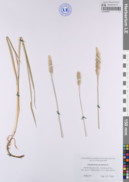
LE 01238355
Alopecurus pratensis L.
Collectors: Haare, Ado Oskarovich Collection date: 20.06.1971. Administrative regions: RU - Leningradskaya Oblast' - Gatchinskiy Rayon. Groups of specimens: Образцы сектора Восточной Европы; Соглашение Минобрнауки №075-15-2021-1056Original label text:Ленинградская область, Гатчинский район, окрестности железнодорожной станции Мариенбург, луг у края дороги.
Record creation: 2023-06-01, Artyom Borodushkin, PhotoScan D2.Citation: Specimen LE 01238355 // Virtual herbarium of Komarov Botanical Institute RAS — http://re.herbariumle.ru/01238355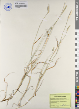
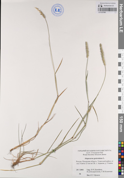
LE 01238509
Alopecurus geniculatus L. det. Myalik A. N. at 04.07.2015
Collectors: Myalik A. N. Field collecting number: 220. Collection date: 04.07.2015. Administrative regions: BY - Brest Oblast - Ivatsevitski Rayon. Groups of specimens: Образцы сектора Восточной Европы; Соглашение Минобрнауки №075-15-2021-1056Original label text:Место сбора: Беларусь, область Брестская, район Ивацевичский, деревня Вулька-Телеханская, 2,3 километра к северо-востоку Условия произрастания: влажная луговина в смешанном лесу
Record creation: 2023-06-05, Artyom Borodushkin, PhotoScan D2.Citation: Specimen LE 01238509 // Virtual herbarium of Komarov Botanical Institute RAS — http://re.herbariumle.ru/01238509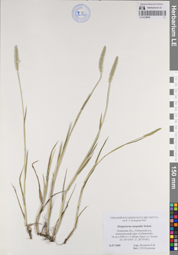
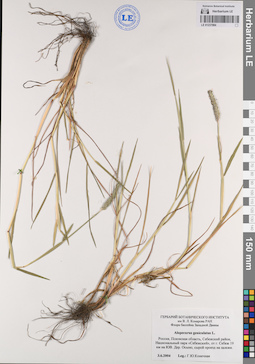
LE 01238956
Alopecurus aequalis Sobol. det. Konechnaya, Galina Yurievna
Collection date: 16.07.2000. Administrative regions: RU - Pskovskaya Oblast' - Sebezhskiy Rayon. Groups of specimens: Образцы сектора Восточной Европы; Соглашение Минобрнауки №075-15-2021-1056Original label text:Россия, Псковская область, Себежский район, национальный парк "Себежский", 18 километров к юго-востоку от города Себежа, берег озера Осыно (N: 56°10'05"; E: 28°39'48").
Coordinates (geographic position): 56° 10′ 5″ N, 28° 39′ 48″ ERecord creation: 2023-06-07, Artyom Borodushkin, PhotoScan D2.Citation: Specimen LE 01238956 // Virtual herbarium of Komarov Botanical Institute RAS — http://re.herbariumle.ru/01238956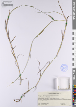
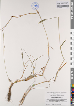
LE 01238983
Alopecurus geniculatus L. det. Unknown at 30.09.2014
Collectors: Unknown Field collecting number: 101. Collection date: 05.08.2014. Administrative regions: BY - Minsk Oblast - Slutski Rayon. Groups of specimens: Образцы сектора Восточной Европы; Соглашение Минобрнауки №075-15-2021-1056Original label text:Беларусь, Минская область, Слуцкий район N 53°03.033' E 27°22.872'
Coordinates (geographic position): 53° 3′ 1.98″ N, 27° 22′ 52.32″ ERecord creation: 2023-06-08, Artyom Borodushkin, PhotoScan D2.Citation: Specimen LE 01238983 // Virtual herbarium of Komarov Botanical Institute RAS — http://re.herbariumle.ru/01238983Место сбора: северо-восточные окрестности деревни Знамя, правобережье реки Ужанка
Условия произрастания: прибрежное сообщество с доминированием манника большого
LE 01240293
Festuca porcii Hack. det. Unknown
Collectors: Degen A., de Field collecting number: 390. Collection date: 11.08.1902. Administrative regions: RO - Judetul Bistrita-Nasaud. Place of collection: Berges Craciunel bei Rodna im Komitat Besztercze-Naszod in Ungarn / гора Крациунель возле Родна в Бистрице-Нэсэуд, Румыния/быв. Венгрия.Groups of specimens: Образцы сектора Восточной Европы; Соглашение Минобрнауки №075-15-2021-1056; A. Kneucker: Gramineae exsiccatae. XIII. Lieferung. 1903Original label text:A. Kneucker: Gramineae exsiccatae. XIII. Lieferung. 1903. Nr. 390. Festuca Porcii Hackel in Bot. Centralbl. VIII, p. 407 (1881) als nom.nud. u. in Hackel Monogr. Fest. p. 147 (1882). Auf grasreichen Wiesen des Berges Craciunel bei Rodna im Komitat Besztercze-Naszod in Ungarn; Kalk. Begleitpflanzen: Phleum Michelii All., Dianthus compactus W. u K., Festuca Apennina Dnt., rubra L., Alopecurus laguriformis Schur., Centaurea Kotschyana Heuff. Ca. 1400 m u.d.M.; 11.Aug. 1902. leg Dr. A. von Degen
Landscape in location of collection: склон горыCoordinates (geographic position): 47° 25′ 19.74″ N, 24° 48′ 54.87″ E ±3000 mRecord creation: 2023-07-05, Artyom Borodushkin, PhotoScan D2.Citation: Specimen LE 01240293 // Virtual herbarium of Komarov Botanical Institute RAS — http://re.herbariumle.ru/01240293