View
Add
Copy
Edit
Delete
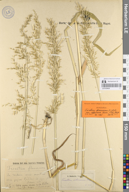
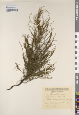
LE 01239429
Groups of specimens: Образцы сектора Сибири и Дальнего Востока России; Типовые образцы сектора Сибири и Дальнего Востока России; Соглашение Минобрнауки №075-15-2021-1056Record creation: 2023-07-17, Marina Yarichina, PhotoScan D2.Citation: Specimen LE 01239429 // Virtual herbarium of Komarov Botanical Institute RAS — http://re.herbariumle.ru/01239429
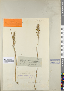
LE 01239428
Groups of specimens: Образцы сектора Сибири и Дальнего Востока России; Типовые образцы сектора Сибири и Дальнего Востока России; Соглашение Минобрнауки №075-15-2021-1056Record creation: 2023-07-17, Marina Yarichina, PhotoScan D2.Citation: Specimen LE 01239428 // Virtual herbarium of Komarov Botanical Institute RAS — http://re.herbariumle.ru/01239428
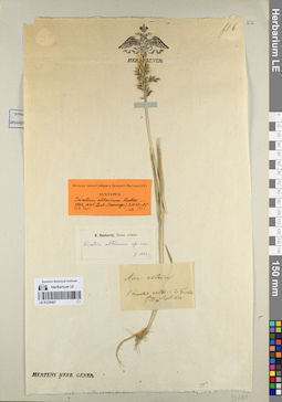
LE 01239427
Groups of specimens: Образцы сектора Сибири и Дальнего Востока России; Типовые образцы сектора Сибири и Дальнего Востока России; Соглашение Минобрнауки №075-15-2021-1056Record creation: 2023-07-17, Marina Yarichina, PhotoScan D2.Citation: Specimen LE 01239427 // Virtual herbarium of Komarov Botanical Institute RAS — http://re.herbariumle.ru/01239427
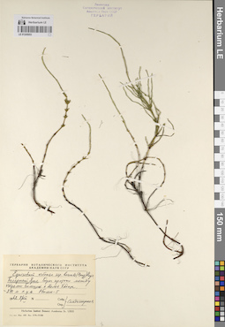
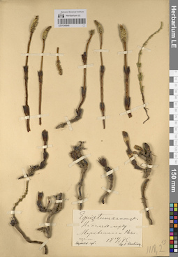
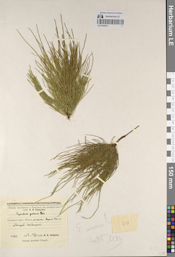
LE 01245053
Equisetum arvense ssp. boreale (Bong.) Rupr. det. Sandomirskaya S. I.
Collectors: Sandomirskaya S. I. Field collecting number: s.n. Collection date: 08.08.1962. Administrative regions: RU - Yamalo-Nenetskiy Avtonomnyy Okrug - Priural'skiy Rayon. Place of collection: Полярный Урал. Берег протоки между оз. Большой Хадатаёганлор (Большая Хадата) и оз. Малый Хадатаёганлор (Малая Хадата).Groups of specimens: Образцы сектора Восточной Европы; Флора Урала и прилегающих территорий (проект); Соглашение Минобрнауки №075-15-2021-1056; Гербарий Ботанического Института Академии наук СССРOriginal label text:Гербарий Ботанического института Академии наук СССР. Equisetum arvense L. ssp. boreale (Bong.) Rupr. Полярный Урал. Берег протоки между озерами Большая и Малая Хадата. Ок. 210 м н.у.м. Обилие-5. 1962 8/VIII. Собр., опр. Сандомирская
Landscape in location of collection: берег протоки между озерамиCoordinates (geographic position): 67° 36′ 58.11″ N, 65° 57′ 10.78″ E ±600 m 210 m a.s.l.Record creation: 2023-07-17, Denis Melnikov, PhotoScan D2.Citation: Specimen LE 01245053 // Virtual herbarium of Komarov Botanical Institute RAS — http://re.herbariumle.ru/01245053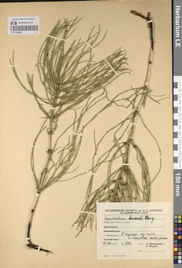
LE 01245052
Equisetum boreale Bong. det. Pobedimova, Evgeniia Georgievna, Mordak, Elena Vladimirovna at 1958
Collectors: Pobedimova, Evgeniia Georgievna; Mordak, Elena Vladimirovna Field collecting number: 442. Collection date: 17.08.1958. Administrative regions: RU - Arkhangel'skaya Oblast' - Mezenskiy Rayon. Place of collection: побережье Белого моря: о. Моржовец, в тундре, по пути к р. Литовка, склон речки.Groups of specimens: Образцы сектора Восточной Европы; Флора Урала и прилегающих территорий (проект); Соглашение Минобрнауки №075-15-2021-1056; Гербарий Ботанического Института Академии наук СССРOriginal label text:Ботанический институт им. В.Л. Комарова Академии наук СССР. Equisetum boreale Bong. Побережье Белого моря: о. Моржовец, в тундре, по пути к Литовке, склон речки. 17-VIIi 1958. № 442. Собр. Е. Победимова и Е. Мордак
Landscape in location of collection: склон рекиHabitat / plant community in location of collecting: тундраCoordinates (geographic position): 66° 44′ 13.42″ N, 42° 36′ 13.56″ E ±8000 mRecord creation: 2023-07-17, Denis Melnikov, PhotoScan D2.Citation: Specimen LE 01245052 // Virtual herbarium of Komarov Botanical Institute RAS — http://re.herbariumle.ru/01245052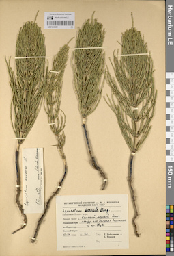
LE 01245051
Equisetum boreale Bong. det. Pobedimova, Evgeniia Georgievna, Mordak, Elena Vladimirovna at 1958
Additional identifications: Equisetum arvense L. det. Kobelevo-Shomenikov at 01.12.1967 Collectors: Pobedimova, Evgeniia Georgievna; Mordak, Elena Vladimirovna Field collecting number: 62. Collection date: 30.07.1958. Administrative regions: RU - Arkhangel'skaya Oblast' - Primorskiy Rayon. Place of collection: побережье Белого моря: Зимний берег, высокий морской берег между пос. Нижняя Золотица и пос. Куя.Groups of specimens: Образцы сектора Восточной Европы; Флора Урала и прилегающих территорий (проект); Соглашение Минобрнауки №075-15-2021-1056; Гербарий Ботанического Института Академии наук СССРOriginal label text:Ботанический институт им. В.Л. Комарова Академии наук СССР. Equisetum boreale Bong. Побережье Белого моря: Зимний берег, высокий морской берег между пос. Нижняя Золотица и пос. Куя. 30-VII 1958. № 62. Собр. Е. Победимова и Е. Мордак
Landscape in location of collection: высокий морской берегCoordinates (geographic position): 65° 40′ 58.95″ N, 40° 9′ 35.23″ E ±10000 mRecord creation: 2023-07-17, Denis Melnikov, PhotoScan D2.Citation: Specimen LE 01245051 // Virtual herbarium of Komarov Botanical Institute RAS — http://re.herbariumle.ru/01245051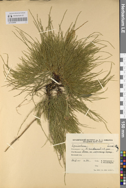
LE 01245050
Equisetum boreale Bong. det. Kolomoitseva, S., Pobedimova, Evgeniia Georgievna at 1957
Collectors: Pobedimova, Evgeniia Georgievna; Kolomoitseva, S. Field collecting number: 341. Collection date: 27.07.1957. Administrative regions: RU - Arkhangel'skaya Oblast' - Primorskiy Rayon. Place of collection: Соловецкие острова, Большой Соловецкий о-в, мыс Печак, по морскому берегу.Groups of specimens: Образцы сектора Восточной Европы; Флора Урала и прилегающих территорий (проект); Соглашение Минобрнауки №075-15-2021-1056; Гербарий Ботанического Института Академии наук СССРOriginal label text:Ботанический институт им. В.Л. Комарова Академии наук СССР. Equisetum boreale Bong. Соловецкие острова, Б. Соловецкий о-в, мыс Печаг, по морскому берегу. 27-VII 1957. № 341. Собр. Е. Победимова и С. Коломойцева
Landscape in location of collection: берег моряCoordinates (geographic position): 64° 57′ 26.58″ N, 35° 44′ 38.7″ E ±1500 mRecord creation: 2023-07-17, Denis Melnikov, PhotoScan D2.Citation: Specimen LE 01245050 // Virtual herbarium of Komarov Botanical Institute RAS — http://re.herbariumle.ru/01245050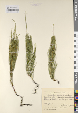
LE 01245049
Equisetum arvense ssp. boreale (Bong.) Tolm. det. Sandomirskaya S. I.
Collectors: Sandomirskaya S. I. Field collecting number: s.n. Collection date: 14.08.1962. Administrative regions: RU - Yamalo-Nenetskiy Avtonomnyy Okrug - Priural'skiy Rayon. Place of collection: Полярный Урал, правый берег р. Большая Хадата в истоках.Groups of specimens: Образцы сектора Восточной Европы; Флора Урала и прилегающих территорий (проект); Соглашение Минобрнауки №075-15-2021-1056; Гербарий Ботанического Института Академии наук СССРOriginal label text:Гербарий Ботанического института Академии наук СССР. Equisetum arvense L. ssp. boreale. Полярный Урал. Прав. берег реки Большая Хадата в истоках. Обилие-4 (в пятнах-5). 1962 14/VIII. Собр., опр. Сандомирская
Landscape in location of collection: правый берег рекиCoordinates (geographic position): 67° 34′ 44.4″ N, 65° 48′ 28.8″ E ±4000 mRecord creation: 2023-07-17, Denis Melnikov, PhotoScan D2.Citation: Specimen LE 01245049 // Virtual herbarium of Komarov Botanical Institute RAS — http://re.herbariumle.ru/01245049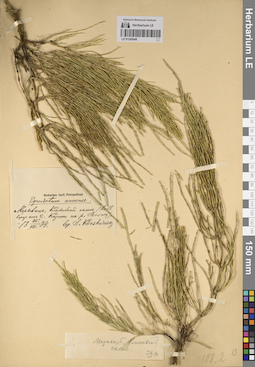
LE 01245048
Equisetum arvense L. det. Korshinsky, Sergei Ivanovitsch at 1884
Collectors: Korshinsky, Sergei Ivanovitsch Field collecting number: s.n. Collection date: 25.07.1884. Administrative regions: RU - Tatarstan - Verkhneuslonskiy Rayon. Place of collection: с. Набережные Моркваши, Кликовский (Клыковский) склон в 19 км от г. Казань.Groups of specimens: Образцы сектора Восточной Европы; Флора Урала и прилегающих территорий (проект); Соглашение Минобрнауки №075-15-2021-1056; Herbarium horti PetropolitaniOriginal label text:Herbarium horti Petropolitani. Equisetum arvense. Моркваш, Кликовский склон (в 18 верст. от г. Казани на р. Волге). 25/VII 1884. Собр. С. Коржинский
Coordinates (geographic position): 55° 46′ 17.85″ N, 48° 50′ 43.92″ E ±3000 mRecord creation: 2023-07-17, Denis Melnikov, PhotoScan D2.Citation: Specimen LE 01245048 // Virtual herbarium of Komarov Botanical Institute RAS — http://re.herbariumle.ru/01245048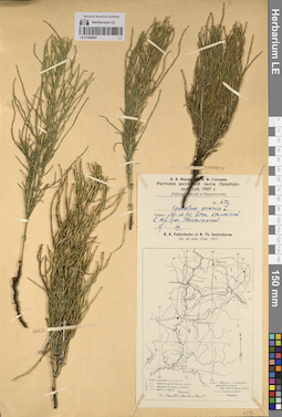
LE 01245047
Equisetum arvense L. det. Fedtschenko, Boris Alexeevich, Gontscharow, Nikolai Fedorovich at 1927
Collectors: Fedtschenko, Boris Alexeevich; Gontscharow, Nikolai Fedorovich Field collecting number: 682. Collection date: 17.08.1927. Administrative regions: RU - Orenburgskaya Oblast'. Subregion: городской округ Орск. Place of collection: луг по берегу р. Каменная в окрестности стан. Таналыкская.Expedition: Б.А. Федченко и Н.Ф. Гончаров. Растения восточной части Оренбургской губ. (1927)Groups of specimens: Образцы сектора Восточной Европы; Флора Урала и прилегающих территорий (проект); Соглашение Минобрнауки №075-15-2021-1056Original label text:Б.А. Федченко и Н.Ф. Гончаров. Растения восточной части Оренбургской губ. 1927 г. (Районы: Орский и Кваркенский). № 682. Equisetum arvense L. Район: Луг по бер. речки Каменной в окр. стан. Таналыкской. 17 VIII. B.A. Fedtschenko et N.Th. Gontscharow. Iter ad distr. Orsk. 1927
Landscape in location of collection: берег рекиHabitat / plant community in location of collecting: лугCoordinates (geographic position): 51° 50′ 11.34″ N, 58° 41′ 44.17″ E ±20000 mRecord creation: 2023-07-17, Denis Melnikov, PhotoScan D2.Citation: Specimen LE 01245047 // Virtual herbarium of Komarov Botanical Institute RAS — http://re.herbariumle.ru/01245047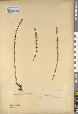
LE 01245046
Groups of specimens: Образцы сектора Восточной Европы; Флора Урала и прилегающих территорий (проект); Соглашение Минобрнауки №075-15-2021-1056Record creation: 2023-07-17, Denis Melnikov, PhotoScan D2.Citation: Specimen LE 01245046 // Virtual herbarium of Komarov Botanical Institute RAS — http://re.herbariumle.ru/01245046
LE 01245045
Equisetum arvense L. det. Korshinsky, Sergei Ivanovitsch at 1885
Collectors: Korshinsky, Sergei Ivanovitsch Field collecting number: s.n. Collection date: 16.05.1885. Administrative regions: RU - Tatarstan - Verkhneuslonskiy Rayon. Place of collection: поля между с. Набережные Моркваши и с. Печищи.Groups of specimens: Образцы сектора Восточной Европы; Флора Урала и прилегающих территорий (проект); Соглашение Минобрнауки №075-15-2021-1056Original label text:Equisetum arvense. На полях между Морквашем и Печищами. Казанск. губ. 16/V 1885. leg. S. Korshinsky
Habitat / plant community in location of collecting: полеCoordinates (geographic position): 55° 46′ 8.23″ N, 48° 54′ 3.33″ E ±3000 mRecord creation: 2023-07-17, Denis Melnikov, PhotoScan D2.Citation: Specimen LE 01245045 // Virtual herbarium of Komarov Botanical Institute RAS — http://re.herbariumle.ru/01245045
LE 01245042
Equisetum arvense L. det. Korshinsky, Sergei Ivanovitsch at 1885
Collectors: Korshinsky, Sergei Ivanovitsch Field collecting number: s.n. Collection date: 15.05.1885. Administrative regions: RU - Tatarstan - Verkhneuslonskiy Rayon. Place of collection: с. Набережные Моркваши, ООПТ Кликовский (Клыковский) склон, южный склон у руч. Кликовка, нижняя часть склона у ключа.Expedition: S. Korshinsky. Plantae gubernii Kasanensis (1885)Groups of specimens: Образцы сектора Восточной Европы; Флора Урала и прилегающих территорий (проект); Соглашение Минобрнауки №075-15-2021-1056Original label text:S. Korzchinsky. Plantae gubernii Kasanensis. Equisetum arvense. Около д. Прибрежный Моркваш. На южном склоне у ручья Кликовки. Почва мергель с перегнойной почвой. В нижней части склона у ключа. Gub. Kasan. Distr. Swiazchsk. leg. S. Korzchinsky
Landscape in location of collection: нижняя часть склона у ключаCoordinates (geographic position): 55° 46′ 50.4″ N, 48° 50′ 29.22″ E ±1000 mRecord creation: 2023-07-17, Denis Melnikov, PhotoScan D2.Citation: Specimen LE 01245042 // Virtual herbarium of Komarov Botanical Institute RAS — http://re.herbariumle.ru/01245042
LE 01245044
Equisetum arvense L. det. Korshinsky, Sergei Ivanovitsch at 1885
Collectors: Korshinsky, Sergei Ivanovitsch Field collecting number: s.n. Collection date: 06.08.1885. Administrative regions: RU - Tatarstan - Verkhneuslonskiy Rayon. Place of collection: поле в 2,1 км от с. Верхний Услон (к дер. Смуровой[?]) (Казанская губ).Groups of specimens: Образцы сектора Восточной Европы; Флора Урала и прилегающих территорий (проект); Соглашение Минобрнауки №075-15-2021-1056Original label text:Equisetum arvense. На поле в 2 верстах от Верхн. Услона (к дер. Смуровой[?]) (Казанск. губ). 6/VIII 1885. leg. S. Korshinsky
Habitat / plant community in location of collecting: полеCoordinates (geographic position): 55° 44′ 18.1″ N, 48° 56′ 17.13″ E ±2000 mRecord creation: 2023-07-17, Denis Melnikov, PhotoScan D2.Citation: Specimen LE 01245044 // Virtual herbarium of Komarov Botanical Institute RAS — http://re.herbariumle.ru/01245044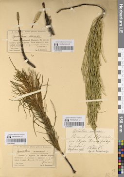
LE 01245043
Equisetum arvense L. det. Korshinsky, Sergei Ivanovitsch at 1885
Collectors: Korshinsky, Sergei Ivanovitsch Field collecting number: s.n. Collection date: 27.05.1885. Administrative regions: RU - Tatarstan - Yelabuzhskiy Rayon. Place of collection: Против с. Старая (?) Мурзиха, на камском (р. Кама) острове, заливаемом в половодье и заросшем б.г. осокорью и ивами. На песчаной косе.Expedition: S. Korshinsky. Plantae gubernii Kasanensis (1885)Groups of specimens: Образцы сектора Восточной Европы; Флора Урала и прилегающих территорий (проект); Соглашение Минобрнауки №075-15-2021-1056Original label text:S. Korzchinsky. Plantae gubernii Kasanensis. Equisetum arvense. Против с. Мурзихи. На камском острове заливаемом в половодье и заросшем б.г. осокорью и ивами. На песчаной косе. 17 мая 1885 г. Gub. Kasan. Distr. Laїschew. leg. S. Korzchinsky
Landscape in location of collection: песчаная косаHabitat / plant community in location of collecting: осокорь и ивы (Salix sp.)Coordinates (geographic position): 55° 43′ 2.68″ N, 51° 47′ 31.16″ E ±1000 mRecord creation: 2023-07-17, Denis Melnikov, PhotoScan D2.Citation: Specimen LE 01245043 // Virtual herbarium of Komarov Botanical Institute RAS — http://re.herbariumle.ru/01245043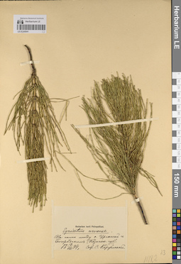
LE 01245041
Equisetum arvense L. det. Korshinsky, Sergei Ivanovitsch at 1884
Collectors: Korshinsky, Sergei Ivanovitsch Field collecting number: s.n. Collection date: 12.08.1884. Administrative regions: RU - Tatarstan - Verkhneuslonskiy Rayon. Place of collection: пашня между с. Урганча и с. Юматово (быв. с. Богородское).Groups of specimens: Образцы сектора Восточной Европы; Флора Урала и прилегающих территорий (проект); Соглашение Минобрнауки №075-15-2021-1056; Herbarium horti PetropolitaniOriginal label text:Herbarium horti Petropolitani. Equisetum arvense. На пашне между с. Урганчей и Богородским (Казанск. губ). 12/VIIi 1884. Собр. С. Коржинский
Habitat / plant community in location of collecting: пашняCoordinates (geographic position): 55° 42′ 2.03″ N, 48° 42′ 30.1″ E ±10000 mRecord creation: 2023-07-17, Denis Melnikov, PhotoScan D2.Citation: Specimen LE 01245041 // Virtual herbarium of Komarov Botanical Institute RAS — http://re.herbariumle.ru/01245041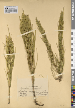
LE 01245040
Equisetum arvense L. det. Korshinsky, Sergei Ivanovitsch at 1884
Collectors: Korshinsky, Sergei Ivanovitsch Field collecting number: s.n. Collection date: 25.07.1884. Administrative regions: RU - Tatarstan - Verkhneuslonskiy Rayon. Place of collection: с. Набережные Моркваши, ООПТ Кликовский (Клыковский) склон.Groups of specimens: Образцы сектора Восточной Европы; Флора Урала и прилегающих территорий (проект); Соглашение Минобрнауки №075-15-2021-1056; Herbarium horti PetropolitaniOriginal label text:Herbarium horti Petropolitani. Equisetum arvense. Моркваш, Кликовский склон (в 18 верст. от г. Казань на р. Волге). 25/VII 1884. leg. S. Korshinsky
Coordinates (geographic position): 55° 46′ 49.18″ N, 48° 50′ 40.96″ E ±5000 mRecord creation: 2023-07-17, Denis Melnikov, PhotoScan D2.Citation: Specimen LE 01245040 // Virtual herbarium of Komarov Botanical Institute RAS — http://re.herbariumle.ru/01245040
LE 01245039
Equisetum arvense L. det. Popova, V. at 1920
Collectors: Popova, V. Field collecting number: s.n. Collection date: 05.08.1920. Administrative regions: RU - Tatarstan - Chistopol'skiy Rayon. Place of collection: Татарстан, Чистопольский р-н, близ г. Чистополь, Куйбышевское водохранилище, пойма р. Кама у с. Змеево.Groups of specimens: Образцы сектора Восточной Европы; Флора Урала и прилегающих территорий (проект); Соглашение Минобрнауки №075-15-2021-1056; Museum Botanicum Academiae Scientiarum PetropolitanaeOriginal label text:Museum Botanicum Academiae Scientiarum Petropolitanae. Equisetum arvense L. Татреспублика. Г. Чистополь. Пойма Камы у сел. Змеева. Приречная часть. Песчаная терраса. Разбросано. 5 VIII 1920. В. Попова
Landscape in location of collection: пойма крупной рекиCoordinates (geographic position): 55° 24′ 27.54″ N, 50° 43′ 6.12″ E ±6000 mRecord creation: 2023-07-17, Denis Melnikov, PhotoScan D2.Citation: Specimen LE 01245039 // Virtual herbarium of Komarov Botanical Institute RAS — http://re.herbariumle.ru/01245039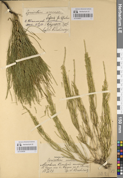
LE 01245037
Equisetum arvense L. det. Korshinsky, Sergei Ivanovitsch at 1884
Collectors: Korshinsky, Sergei Ivanovitsch Field collecting number: s.n. Collection date: 11.07.1884. Administrative regions: RU - Chuvashskaya Respublika - Kanashskiy Rayon. Place of collection: с. Ачакасы (Татмышево), берег р. Малый Цивиль, лес.Groups of specimens: Образцы сектора Восточной Европы; Флора Урала и прилегающих территорий (проект); Соглашение Минобрнауки №075-15-2021-1056Original label text:Equisetum arvense. с. Татмышево, берег р. Цивили. лес. 11/VII 1884. (Казанск. губ). leg. S. Korshinsky
Landscape in location of collection: берег рекиHabitat / plant community in location of collecting: лесCoordinates (geographic position): 55° 29′ 50.34″ N, 47° 10′ 5.49″ E ±3000 mRecord creation: 2023-07-17, Denis Melnikov, PhotoScan D2.Citation: Specimen LE 01245037 // Virtual herbarium of Komarov Botanical Institute RAS — http://re.herbariumle.ru/01245037
LE 01245038
Equisetum arvense L. det. Korshinsky, Sergei Ivanovitsch at 1884
Collectors: Korshinsky, Sergei Ivanovitsch Field collecting number: s.n. Collection date: 25.07.1884. Administrative regions: RU - Tatarstan - Verkhneuslonskiy Rayon. Place of collection: с. Набережные Моркваши, ООПТ Кликовский (Клыковский) склон.Groups of specimens: Образцы сектора Восточной Европы; Флора Урала и прилегающих территорий (проект); Соглашение Минобрнауки №075-15-2021-1056; Herbarium horti PetropolitaniOriginal label text:Herbarium horti Petropolitani. Equisetum arvense. Моркваш, Кликовский склон (в 18 верст. от г. Казань на р. Волге). 25/VII 1884. leg. S. Korshinsky
Coordinates (geographic position): 55° 46′ 52.79″ N, 48° 50′ 30.92″ E ±1000 mRecord creation: 2023-07-17, Denis Melnikov, PhotoScan D2.Citation: Specimen LE 01245038 // Virtual herbarium of Komarov Botanical Institute RAS — http://re.herbariumle.ru/01245038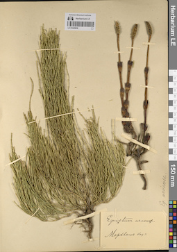
LE 01245036
Equisetum arvense L. det. Busch
Collectors: Busch Field collecting number: s.n. Collection date: 1900. Administrative regions: RU - Tatarstan - Verkhneuslonskiy Rayon. Place of collection: с. Набережные Моркваши (?).Groups of specimens: Образцы сектора Восточной Европы; Флора Урала и прилегающих территорий (проект); Соглашение Минобрнауки №075-15-2021-1056Original label text:Equisetum arvense. Моркваш Каз.г
Coordinates (geographic position): 55° 46′ 52.79″ N, 48° 50′ 30.92″ E ±2000 mRecord creation: 2023-07-17, Denis Melnikov, PhotoScan D2.Citation: Specimen LE 01245036 // Virtual herbarium of Komarov Botanical Institute RAS — http://re.herbariumle.ru/01245036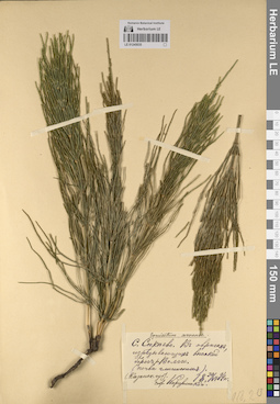
LE 01245035
Equisetum arvense L. det. Korshinsky, Sergei Ivanovitsch at 1884
Collectors: Korshinsky, Sergei Ivanovitsch Field collecting number: s.n. Collection date: 30.06.1884. Administrative regions: RU - Tatarstan - Kamsko-Ust'inskiy Rayon. Place of collection: Казанская губ., с. Сюкеево, овраги на берегу р. Волга.Groups of specimens: Образцы сектора Восточной Европы; Флора Урала и прилегающих территорий (проект); Соглашение Минобрнауки №075-15-2021-1056Original label text:Equisetum arvense. С. Сюкеево. В оврагах, изрезывающих высокий берег р. Волги. (почва глинистая). (Казанск. губ.). 30/VI 1884 г. собр. Коржинский
Landscape in location of collection: овраги, изрезывающие высокий берег реки ВолгаSubstrate in collecting location: глинаCoordinates (geographic position): 55° 4′ 3″ N, 49° 1′ 12.75″ E ±3000 mRecord creation: 2023-07-17, Denis Melnikov, PhotoScan D2.Citation: Specimen LE 01245035 // Virtual herbarium of Komarov Botanical Institute RAS — http://re.herbariumle.ru/01245035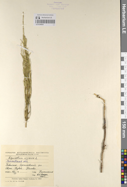
LE 01245034
Equisetum arvense L. det. Haare, Ado Oskarovich at 1991
Collectors: Kalashnikov, L. Field collecting number: s.n. Collection date: 10.08.1935. Administrative regions: RU - Ulyanovsk Oblast - Sengileyevskiy Rayon. Place of collection: Поволжье, овраг Кувой, тальвег.Groups of specimens: Образцы сектора Восточной Европы; Флора Урала и прилегающих территорий (проект); Соглашение Минобрнауки №075-15-2021-1056; Гербарий Ботанического Института Академии наук СССРOriginal label text:Гербарий Ботанического института Академии наук СССР. Equisetum arvense L. Ульяновская обл. Поволжье. Сенгилеевский р-н. Овраг Кувой. Тальвег. 1935 г. 10/VIII. Собр. Калашников. Опр. А.О. Хааре 1991 г
Landscape in location of collection: овраг Кувой, тальвегRecord creation: 2023-07-17, Denis Melnikov, PhotoScan D2.Citation: Specimen LE 01245034 // Virtual herbarium of Komarov Botanical Institute RAS — http://re.herbariumle.ru/01245034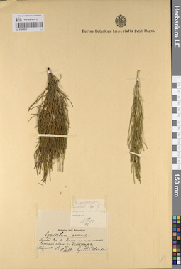
LE 01245033
Equisetum arvense L. det. Ostankov, A. (объединить с Ostankow, A.) at 1882
Collectors: Ostankov, A. (объединить с Ostankow, A.) Field collecting number: s.n. Collection date: 27.07.1882. Administrative regions: RU - Chuvashskaya Respublika - Cheboksarskiy Rayon. Place of collection: Г. Чебоксары. Луговой берег р. Волга по песчаным местам.Groups of specimens: Образцы сектора Восточной Европы; Флора Урала и прилегающих территорий (проект); Соглашение Минобрнауки №075-15-2021-1056; Herbarium horti PetropolitaniOriginal label text:[1]Г. Чебоксары. Луговой бер. р. Волги по песчаным местам. 27 VII 1882. [2] Herbarium horti Petropolitani. Equisetum arvense. Луговой бер. р. Волги по песчаным местам около г. Чебоксар (Казанск. губ.) 27 VII 1882. leg. A. Ostankow
Landscape in location of collection: луговой берег реки Волга по песчаным местамHabitat / plant community in location of collecting: лугSubstrate in collecting location: песокCoordinates (geographic position): 56° 9′ 22.03″ N, 47° 13′ 1.82″ E ±20000 mRecord creation: 2023-07-17, Denis Melnikov, PhotoScan D2.Citation: Specimen LE 01245033 // Virtual herbarium of Komarov Botanical Institute RAS — http://re.herbariumle.ru/01245033
LE 01245031
Equisetum arvense L. det. Korshinsky, Sergei Ivanovitsch
Collectors: Korshinsky, Sergei Ivanovitsch Field collecting number: s.n. Collection date: 03.07.1886. Administrative regions: RU - Sverdlovskaya Oblast' - Krasnoufimskiy Rayon. Place of collection: Г. Красноуфимск. На заливных лугах р. Уфа под Соколовым камнем (в уреме).Expedition: S. Korzchinsky. Flora cis- et transwolgensis (1885-1887) (1885 -1887)Groups of specimens: Образцы сектора Восточной Европы; Флора Урала и прилегающих территорий (проект); Соглашение Минобрнауки №075-15-2021-1056Original label text:S. Korzchinsky. Flora Cis- et Transwolgensis. Equisetum arvense. Г. Красноуфимск. На заливных лугах р. Уфы под Соколовым камнем (в уреме). Gub. Perm. Distr. Krassnoufimsk. 3 июля 1886 г. leg. S. Korzchinsky
Landscape in location of collection: под Соколовым камнем (в уреме)Habitat / plant community in location of collecting: заливной лугCoordinates (geographic position): 56° 35′ 52.72″ N, 57° 45′ 30.28″ E ±5000 mRecord creation: 2023-07-17, Denis Melnikov, PhotoScan D2.Citation: Specimen LE 01245031 // Virtual herbarium of Komarov Botanical Institute RAS — http://re.herbariumle.ru/01245031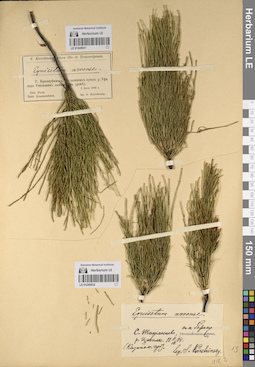
LE 01245032
Equisetum arvense L. det. Korshinsky, Sergei Ivanovitsch at 1884
Collectors: Korshinsky, Sergei Ivanovitsch Field collecting number: s.n. Collection date: 11.07.1884. Administrative regions: RU - Chuvashskaya Respublika - Kanashskiy Rayon. Place of collection: С. Татмышево (Ачакасы), на берегу р. Малый Цивиль.Groups of specimens: Образцы сектора Восточной Европы; Флора Урала и прилегающих территорий (проект); Соглашение Минобрнауки №075-15-2021-1056Original label text:Equisetum arvense. С. Татмышево, на берегу р. Цивили (Казанск.губ). 11.VII.1884. leg. S. Korshinsky
Landscape in location of collection: берег рекиCoordinates (geographic position): 55° 29′ 35.09″ N, 47° 10′ 27.63″ E ±2000 mRecord creation: 2023-07-17, Denis Melnikov, PhotoScan D2.Citation: Specimen LE 01245032 // Virtual herbarium of Komarov Botanical Institute RAS — http://re.herbariumle.ru/01245032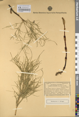
LE 01245030
Equisetum arvense L. det. Claus, Karl Ernst
Collectors: Claus, Karl Ernst Field collecting number: 24,1. Collection date: 1800. Administrative regions: RU - Tatarstan - Gorod Kazan'. Place of collection: г. Казань.Groups of specimens: Образцы сектора Восточной Европы; Флора Урала и прилегающих территорий (проект); Соглашение Минобрнауки №075-15-2021-1056; Herbarium J. Klinge; Hb. C. ClausOriginal label text:XXIV,1. Equisetaceae. Equisetum arvense L. Хвощ полевой; Земляные орехи. Апрель-Май. На полях, лугах и лесных полянах. Стебель его (herba Equiseti minoris) прежде употреблялся в медицине, как мочегонное средство. Вреден, как сорная трава на полях и нездоровой корм. hb C Claus, Kasan
Coordinates (geographic position): 55° 47′ 46.06″ N, 49° 6′ 23.09″ E ±20000 mRecord creation: 2023-07-17, Denis Melnikov, PhotoScan D2.Citation: Specimen LE 01245030 // Virtual herbarium of Komarov Botanical Institute RAS — http://re.herbariumle.ru/01245030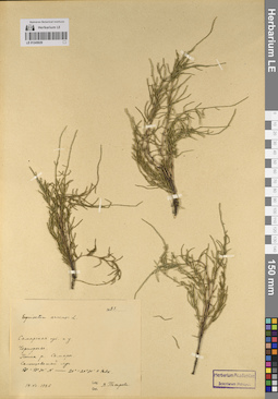
LE 01245029
Equisetum arvense L. det. Petrova, V. at 1926
Collectors: Petrova, V. Field collecting number: 83. Collection date: 14.07.1926. Administrative regions: RU - Samarskaya Oblast' - Volzhskiy Rayon. Place of collection: Самарская губ. и у. с. Черноречье. Пойма р. Самара. Солонцеватый луг.Groups of specimens: Образцы сектора Восточной Европы; Флора Урала и прилегающих территорий (проект); Соглашение Минобрнауки №075-15-2021-1056Original label text:№ 83. Equisetum arvense L. Самарская губ. и у. Черноречье. Пойма р. Самары. Солонцеватый луг. 53° - 53°30' N - 20° - 20° 30' о Равк. 14.07.1926. Leg. Det. В. Петрова
Landscape in location of collection: пойма реки СамараHabitat / plant community in location of collecting: солонцеватый лугSubstrate in collecting location: солонецCoordinates (geographic position): 53° 11′ 37.86″ N, 50° 22′ 15.42″ E ±5000 mRecord creation: 2023-07-17, Denis Melnikov, PhotoScan D2.Citation: Specimen LE 01245029 // Virtual herbarium of Komarov Botanical Institute RAS — http://re.herbariumle.ru/01245029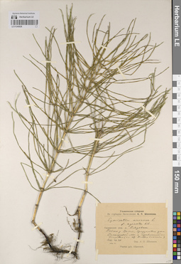
LE 01245028
Equisetum arvense L. f. agreste Klinge det. Schennikov, Alexander Petrovich
Collectors: Schennikov, Alexander Petrovich Field collecting number: s.n. Collection date: 30.07.1916. Administrative regions: RU - Ulyanovsk Oblast - Radishchevskiy Rayon. Place of collection: Сызранский уезд. с. Вязовка. Пойма р. Волга, прирусловая зона. Осокоровый лес с травянистым покровом (главным образом, Bromus inermis).Expedition: Ульяновская губерния. Из гербария Экспедиции А.П. Шенникова (1914 -1919)Groups of specimens: Образцы сектора Восточной Европы; Флора Урала и прилегающих территорий (проект); Соглашение Минобрнауки №075-15-2021-1056Original label text:Ульяновская губерния. Из гербария Экспедиции А.П. Шенникова. Equisetum arvense L. f. agreste Kl. Сызранский уезд. с. Вязовка. Пойма р. Волги, прирусловая зона. Осокоровый лес с травянистым покровом (гл.обр. Bromus inermis). 1916.VII.30. нов.ст. Опр. А.П. Шенников. Plantae gub. Uljanowsk
Landscape in location of collection: пойма реки Волга, прирусловая зонаHabitat / plant community in location of collecting: Осокоровый лес с травянистым покровом (главным образом, Bromus inermis)Coordinates (geographic position): 52° 51′ 7.04″ N, 48° 22′ 28.41″ E ±2000 mRecord creation: 2023-07-17, Denis Melnikov, PhotoScan D2.Citation: Specimen LE 01245028 // Virtual herbarium of Komarov Botanical Institute RAS — http://re.herbariumle.ru/01245028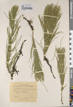
LE 01245027
Equisetum arvense L. var. ramulosum Rupr. f. erectum Klinge det. Schennikov, Alexander Petrovich
Collectors: Schennikov, Alexander Petrovich Field collecting number: s.n. Collection date: 11.06.1916. Administrative regions: RU - Ulyanovsk Oblast - Baryshskiy Rayon. Place of collection: Карсунский уезд, с. Старая Зиновьевка (с. Новый Дол). Пойма р. Барыш.Expedition: Ульяновская губерния. Из гербария Экспедиции А.П. Шенникова (1914 -1919)Groups of specimens: Образцы сектора Восточной Европы; Флора Урала и прилегающих территорий (проект); Соглашение Минобрнауки №075-15-2021-1056Original label text:Ульяновская губерния. Из гербария Экспедиции А.П. Шенникова. Equisetum arvense L. v. ramulosum Rupr. f. erectum Milde. Карсунский уезд, с. Старая Зиновьевка. Пойма р. Барыша. 1916.VI.11. нов.ст. Опр. А.П. Шенников. Plantae gub. Uljanowsk
Landscape in location of collection: пойма рекиCoordinates (geographic position): 53° 48′ 39.05″ N, 47° 9′ 29.53″ E ±2000 mRecord creation: 2023-07-17, Denis Melnikov, PhotoScan D2.Citation: Specimen LE 01245027 // Virtual herbarium of Komarov Botanical Institute RAS — http://re.herbariumle.ru/01245027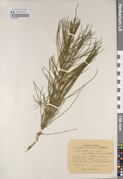
LE 01245026
Equisetum arvense L. var. agreste Klinge f. boreale Milde det. Schennikov, Alexander Petrovich
Collectors: Schennikov, Alexander Petrovich Field collecting number: s.n. Collection date: 20.06.1916. Administrative regions: RU - Ulyanovsk Oblast - Veshkaymskiy Rayon. Place of collection: Карсунский уезд. д. Мухино, долина р. Барыш. Болотистый лес (Betula pubescens+Alnus glutinosa) в притеррасной зоне.Expedition: Ульяновская губерния. Из гербария Экспедиции А.П. Шенникова (1914 -1919)Groups of specimens: Образцы сектора Восточной Европы; Флора Урала и прилегающих территорий (проект); Соглашение Минобрнауки №075-15-2021-1056Original label text:Ульяновская губерния. Из гербария Экспедиции А.П. Шенникова. Equisetum arvense L. v. agreste Kl. f. boreale Milde. Карсунский уезд. д. Мухино, долина р. Барыша. Болотистый лес (Bet. pub.+Alnus glut.) в притерр. зоне. 1916.VI.20. нов.ст. Опр. А.П. Шенников. Plantae gub. Uljanowsk
Landscape in location of collection: Болотистый лес (Betula pubescens+Alnus glutinosa) в притеррасной зонеHabitat / plant community in location of collecting: Болотистый лес (Betula pubescens+Alnus glutinosa)Coordinates (geographic position): 53° 54′ 45.07″ N, 47° 12′ 16.88″ E ±2000 mRecord creation: 2023-07-17, Denis Melnikov, PhotoScan D2.Citation: Specimen LE 01245026 // Virtual herbarium of Komarov Botanical Institute RAS — http://re.herbariumle.ru/01245026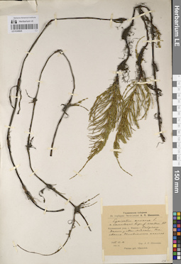
LE 01245025
Equisetum arvense L. var. ramulosum Rupr. f. erectum Klinge det. Schennikov, Alexander Petrovich
Collectors: Schennikov, Alexander Petrovich Field collecting number: s.n. Collection date: 10.06.1915. Administrative regions: RU - Nizhegorodskaya Oblast' - Pil'ninskiy Rayon. Place of collection: Курмышский уезд, с. Медяны-Петрякса. Долина р. Малая Медяна. На свежих делювиальных наносах.Expedition: Ульяновская губерния. Из гербария Экспедиции А.П. Шенникова (1914 -1919)Groups of specimens: Образцы сектора Восточной Европы; Флора Урала и прилегающих территорий (проект); Соглашение Минобрнауки №075-15-2021-1056Original label text:Ульяновская губерния. Из гербария Экспедиции А.П. Шенникова. Equisetum arvense L. v. ramulosum Rupr., f. erectum Kl. Курмышский уезд, с. Медяны-Петрякса. Долина р. Мал. Медянки. На свежих делювиальных наносах. 1915.VI.10. нов.ст. Опр. А.П. Шенников. Plantae gub. Uljanovsk
Landscape in location of collection: долина рекиSubstrate in collecting location: свежие делювиальные наносыCoordinates (geographic position): 55° 26′ 56.12″ N, 46° 6′ 46.81″ E ±5000 mRecord creation: 2023-07-17, Denis Melnikov, PhotoScan D2.Citation: Specimen LE 01245025 // Virtual herbarium of Komarov Botanical Institute RAS — http://re.herbariumle.ru/01245025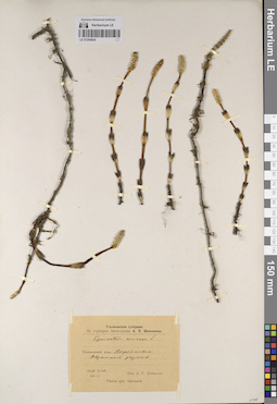
LE 01245024
Equisetum arvense L. det. Schennikov, Alexander Petrovich at 1914
Collectors: Schennikov, Alexander Petrovich Field collecting number: s.n. Collection date: 10.05.1914. Administrative regions: RU - Ulyanovsk Oblast - Inzenskiy Rayon. Place of collection: Ульяновский уезд. д. Вырыпаевка, овражный размыв.Expedition: Ульяновская губерния. Из гербария Экспедиции А.П. Шенникова (1914 -1919)Groups of specimens: Образцы сектора Восточной Европы; Флора Урала и прилегающих территорий (проект); Соглашение Минобрнауки №075-15-2021-1056Original label text:Ульяновская губерния. Из гербария Экспедиции А.П. Шенникова. Equisetum arvense L. Ульяновский уезд. Вырыпаевка. Овражный размыв. 1914.V.10. нов.ст. Опр. А.П. Шенников. Plantae gub. Uljanowsk
Landscape in location of collection: овражный размывCoordinates (geographic position): 53° 50′ 50.67″ N, 46° 33′ 3.57″ E ±1000 mRecord creation: 2023-07-17, Denis Melnikov, PhotoScan D2.Citation: Specimen LE 01245024 // Virtual herbarium of Komarov Botanical Institute RAS — http://re.herbariumle.ru/01245024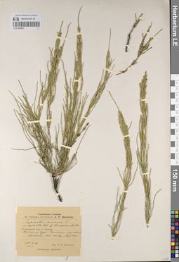
LE 01245023
Equisetum arvense L. var. agreste Klinge f. boreale Milde det. Schennikov, Alexander Petrovich
Collectors: Schennikov, Alexander Petrovich Field collecting number: s.n. Collection date: 17.06.1915. Administrative regions: RU - Nizhegorodskaya Oblast' - Pil'ninskiy Rayon. Place of collection: Курмышский уезд, с. Медяны. Пойма р. Сура. Большая луговая поляна на остр. "Кривое".Expedition: Ульяновская губерния. Из гербария Экспедиции А.П. Шенникова (1914 -1919)Groups of specimens: Образцы сектора Восточной Европы; Флора Урала и прилегающих территорий (проект); Соглашение Минобрнауки №075-15-2021-1056Original label text:Ульяновская губерния. Из гербария Экспедиции А.П. Шенникова. Equisetum arvense L. v. agreste Kl. f. boreale Milde. Курмышский уезд, с. Медяны. Пойма р. Суры. Большая луговая поляна на остр. "Кривое". 1915.VI.17. нов.ст. Опр. А.П. Шенников. Plantae gub. Uljanowsk
Landscape in location of collection: пойма реки, большая луговая поляна на острове "Кривое"Habitat / plant community in location of collecting: большая луговая полянаCoordinates (geographic position): 55° 30′ 33.51″ N, 46° 10′ 22.33″ E ±7000 mRecord creation: 2023-07-17, Denis Melnikov, PhotoScan D2.Citation: Specimen LE 01245023 // Virtual herbarium of Komarov Botanical Institute RAS — http://re.herbariumle.ru/01245023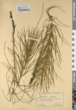
LE 01245022
Equisetum arvense L. det. Korshinsky, Sergei Ivanovitsch at 1885
Collectors: Korshinsky, Sergei Ivanovitsch Field collecting number: s.n. Collection date: 10.06.1885. Administrative regions: RU - Samarskaya Oblast' - Chelno-Vershinskiy Rayon. Place of collection: заливной луг левого берега р. Кондурча, против дер. Старое Иглайкино.Expedition: S. Korzchinsky. Flora cis- et transwolgensis (1885-1887) (1885 -1887)Groups of specimens: Образцы сектора Восточной Европы; Флора Урала и прилегающих территорий (проект); Соглашение Минобрнауки №075-15-2021-1056Original label text:[1] S. Korzchinsky Flora Cis- et Transwolgensis. Equisetum arvense. Против дер. Иглайкиной. На заливных лугах левого берега р. Кондурчи. Gub. Samara. Distr. Samara. 10 июня 1885 г. leg. S. Korzchinsky
Landscape in location of collection: заливной луг левого берега рекиHabitat / plant community in location of collecting: заливной лугCoordinates (geographic position): 54° 23′ 43.86″ N, 50° 57′ 36.31″ E ±2000 mRecord creation: 2023-07-17, Denis Melnikov, PhotoScan D2.Citation: Specimen LE 01245022 // Virtual herbarium of Komarov Botanical Institute RAS — http://re.herbariumle.ru/01245022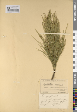
LE 01245021
Equisetum arvense L. det. Korshinsky, Sergei Ivanovitsch at 1885
Collectors: Korshinsky, Sergei Ivanovitsch Field collecting number: s.n. Collection date: 21.06.1885. Administrative regions: RU - Samarskaya Oblast' - Gorodskoy okrug Samara. Place of collection: правый берег р. Волга, против г. Самара, приречные пески и песчаные заливные луга правого берега р. Волга.Expedition: S. Korzchinsky. Flora cis- et transwolgensis (1885-1887) (1885 -1887)Groups of specimens: Образцы сектора Восточной Европы; Флора Урала и прилегающих территорий (проект); Соглашение Минобрнауки №075-15-2021-1056Original label text:[1] S. Korzchinsky Flora Cis- et Transwolgensis. Equisetum arvense. Против г. Самары. На приречных песках и песчаных заливных лугах правого берега Волги. Gub. Simbirsk. Distr. Sysran. 21 июня 1885 г. leg. S. Korzchinsky. [2] На приречных песках и песчаных заливн. луг. прав. бер. Волги против Самары. 21/VI 1885
Landscape in location of collection: приречные пески и песчаные заливные луга правого берега реки ВолгаSubstrate in collecting location: приречный песокCoordinates (geographic position): 53° 14′ 5.23″ N, 50° 6′ 42.88″ E ±10000 mRecord creation: 2023-07-17, Denis Melnikov, PhotoScan D2.Citation: Specimen LE 01245021 // Virtual herbarium of Komarov Botanical Institute RAS — http://re.herbariumle.ru/01245021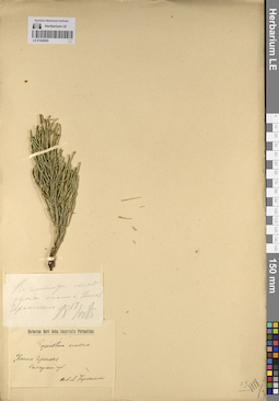
LE 01245020
Equisetum arvense L. det. Kоrzhinska, L. at 1885
Collectors: Kоrzhinska, L. Field collecting number: s.n. Collection date: 17.06.1885. Administrative regions: RU - Samarskaya Oblast' - Kinel'-Cherkasskiy Rayon. Place of collection: г. Кинель-Черкасск.Groups of specimens: Образцы сектора Восточной Европы; Флора Урала и прилегающих территорий (проект); Соглашение Минобрнауки №075-15-2021-1056; Herbarium Horti botan. Imperialis PetropolitaniOriginal label text:[1]На глинистом склоне оврага около с. Кинель Черкасского. 17/VI 1885 [2] Herbarium Horti botan. Imperialis Petropolitani. Equisetum arvense. Кинель Черкасская. Самарская губ. соб. Л. Коржинска[я]
Landscape in location of collection: склон оврагаSubstrate in collecting location: глинаCoordinates (geographic position): 53° 29′ 39.92″ N, 51° 28′ 48.94″ E ±10000 mRecord creation: 2023-07-17, Denis Melnikov, PhotoScan D2.Citation: Specimen LE 01245020 // Virtual herbarium of Komarov Botanical Institute RAS — http://re.herbariumle.ru/01245020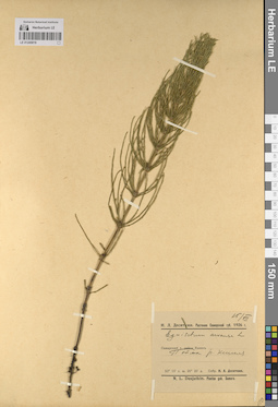
LE 01245019
Equisetum arvense L. det. Desjatkin, N. L. at 1926
Collectors: Desjatkin, N. L. Field collecting number: s.n. Collection date: 15.07.1926. Administrative regions: RU - Samarskaya Oblast' - Kinel'-Cherkasskiy Rayon. Place of collection: Самарский у. район Кинель. Пойма р. Большой Кинель. 53° 15' с.ш. 20° 20' д.Expedition: Н.Л. Десяткин. Растения Самарской губ. 1926 г. (1926)Groups of specimens: Образцы сектора Восточной Европы; Флора Урала и прилегающих территорий (проект); Соглашение Минобрнауки №075-15-2021-1056Original label text:15/VII. Н.Л. Десяткин. Растения Самарской губ. 1926 г. Equisetum arvense L. Самарский у. район Кинель. Пойма р. Кинеля. 53° 15' с.ш. 20° 20' д. Собр. Н.Л. Десяткин. N.L. Desjatkin. Plantae gub. Samara
Landscape in location of collection: пойма рекиCoordinates (geographic position): 53° 29′ 52.27″ N, 51° 31′ 2.18″ E ±125000 mRecord creation: 2023-07-17, Denis Melnikov, PhotoScan D2.Citation: Specimen LE 01245019 // Virtual herbarium of Komarov Botanical Institute RAS — http://re.herbariumle.ru/01245019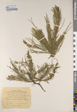
LE 01245018
Equisetum arvense L. var. agreste Klinge f. boreale Milde det. Schennikov, Alexander Petrovich
Collectors: Schennikov, Alexander Petrovich Field collecting number: s.n. Collection date: 27.06.1914. Administrative regions: RU - Ulyanovsk Oblast - Surskiy Rayon. Place of collection: Карсунский уезд. с. Малый Барышок, размыв лугового берега р. Барыш.Expedition: Ульяновская губерния. Из гербария Экспедиции А.П. Шенникова (1914 -1919)Groups of specimens: Образцы сектора Восточной Европы; Флора Урала и прилегающих территорий (проект); Соглашение Минобрнауки №075-15-2021-1056Original label text:Ульяновская губерния. Из гербария Экспедиции А.П. Шенникова. Equisetum arvense L. v. agreste Kl. f. boreale Milde. Карсунский уезд. с. Малый Барышок. Размыв лугового берега р. Барыша. 1914.VI.27. нов.ст. Опр. А.П. Шенников. Plantae gub. Uljanowsk
Landscape in location of collection: размыв лугового берега рекиCoordinates (geographic position): 54° 32′ 30.11″ N, 47° 0′ 47.99″ E ±1300 mRecord creation: 2023-07-17, Denis Melnikov, PhotoScan D2.Citation: Specimen LE 01245018 // Virtual herbarium of Komarov Botanical Institute RAS — http://re.herbariumle.ru/01245018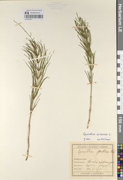
LE 01245017
Equisetum arvense L. det. Haare, Ado Oskarovich at 10.1993
Additional identifications: Equisetum pratense Ehrh. det. Janischewsky, Dmitriy Erastovich at 1900 Collectors: Janischewsky, Dmitriy Erastovich Field collecting number: s.n. Collection date: 20.05.1900. Administrative regions: RUSaratovskaya Oblast' - Novouzenskiy Rayon. Place of collection: Новоузенский уезд, Долговская крестьянская дача, дубовая рощица.Expedition: Гербарий Самарской губернии, собранный Д. Янишевским (1900 -1909)Groups of specimens: Образцы сектора Восточной Европы; Флора Урала и прилегающих территорий (проект); Соглашение Минобрнауки №075-15-2021-1056Original label text:Гербарий Самарской губернии. Equisetum pratense Ehrh. Новоузенского уезда. Местонахождение: Долговск. крестьянск. дача. Местообитание: дубовая рощица. Время сбора: 20.V.1900. Собранный Д. Янишевским
Habitat / plant community in location of collecting: дубовая рощаCoordinates (geographic position): 51° 30′ 3.78″ N, 46° 7′ 26.59″ E ±200000 mRecord creation: 2023-07-17, Denis Melnikov, PhotoScan D2.Citation: Specimen LE 01245017 // Virtual herbarium of Komarov Botanical Institute RAS — http://re.herbariumle.ru/01245017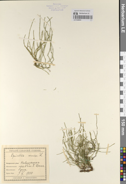
LE 01245016
Equisetum arvense L. det. Janischewsky, Dmitriy Erastovich at 1900
Collectors: Janischewsky, Dmitriy Erastovich Field collecting number: s.n. Collection date: 09.05.1900. Administrative regions: RUSaratovskaya Oblast' - Novouzenskiy Rayon. Place of collection: г. Новоузенск, берега на правой стороне р. Большой Узень.Expedition: Гербарий Самарской губернии, собранный Д. Янишевским (1900 -1909)Groups of specimens: Образцы сектора Восточной Европы; Флора Урала и прилегающих территорий (проект); Соглашение Минобрнауки №075-15-2021-1056Original label text:Гербарий Самарской губернии. Equisetum arvense L. Новоузенского уезда. Новоузенск. Местонахождение: прав. ст. Б. Узеня. Местообитание: берега. Время сбора: 9.V.1900. собранный Д. Янишевским
Landscape in location of collection: правый берег рекиCoordinates (geographic position): 50° 26′ 56.71″ N, 48° 7′ 48.02″ E ±5000 mRecord creation: 2023-07-17, Denis Melnikov, PhotoScan D2.Citation: Specimen LE 01245016 // Virtual herbarium of Komarov Botanical Institute RAS — http://re.herbariumle.ru/01245016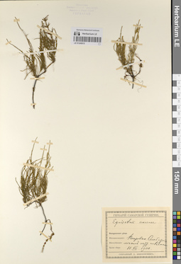
LE 01245015
Equisetum arvense L. det. Janischewsky, Dmitriy Erastovich at 1900
Collectors: Janischewsky, Dmitriy Erastovich Field collecting number: s.n. Collection date: 11.07.1900. Administrative regions: RU - Saratovskaya Oblast' - Engel'sskiy Rayon. Place of collection: Покровская Слобода, лесной остров на р. Волга.Expedition: Гербарий Самарской губернии, собранный Д. Янишевским (1900 -1909)Groups of specimens: Образцы сектора Восточной Европы; Флора Урала и прилегающих территорий (проект); Соглашение Минобрнауки №075-15-2021-1056Original label text:Гербарий Самарской губернии. Equisetum arvense. Новоузенского уезда. Местонахождение: Покровская Слобода. Местообитание: лесной остр. на Волге. Время сбора: 11.VII.1900. собранный Д. Янишевским
Landscape in location of collection: лесной островHabitat / plant community in location of collecting: лесCoordinates (geographic position): 51° 29′ 2.73″ N, 46° 2′ 20.84″ E ±15000 mRecord creation: 2023-07-17, Denis Melnikov, PhotoScan D2.Citation: Specimen LE 01245015 // Virtual herbarium of Komarov Botanical Institute RAS — http://re.herbariumle.ru/01245015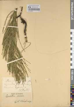
LE 01245014
Groups of specimens: Образцы сектора Восточной Европы; Флора Урала и прилегающих территорий (проект); Соглашение Минобрнауки №075-15-2021-1056Record creation: 2023-07-17, Denis Melnikov, PhotoScan D2.Citation: Specimen LE 01245014 // Virtual herbarium of Komarov Botanical Institute RAS — http://re.herbariumle.ru/01245014
LE 01245013
Groups of specimens: Образцы сектора Восточной Европы; Флора Урала и прилегающих территорий (проект); Соглашение Минобрнауки №075-15-2021-1056Record creation: 2023-07-17, Denis Melnikov, PhotoScan D2.Citation: Specimen LE 01245013 // Virtual herbarium of Komarov Botanical Institute RAS — http://re.herbariumle.ru/01245013
LE 01245012
Equisetum arvense L. det. Lebedev, S. P.
Administrative regions: RU - Ulyanovsk Oblast - Maynskiy Rayon. Groups of specimens: Образцы сектора Восточной Европы; Флора Урала и прилегающих территорий (проект); Соглашение Минобрнауки №075-15-2021-1056; Herbarium Universitatis PetropolitanaeCoordinates (geographic position): 54° 2′ 25.54″ N, 47° 51′ 33.55″ E ±3000 mRecord creation: 2023-07-17, Denis Melnikov, PhotoScan D2.Citation: Specimen LE 01245012 // Virtual herbarium of Komarov Botanical Institute RAS — http://re.herbariumle.ru/01245012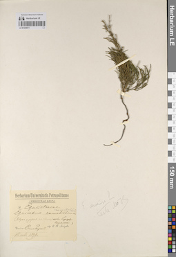
LE 01245011
Equisetum arvense L. det. M.N.
Additional identifications: Equisetum ramosissimum Desf. det. Lebedev, S. P.; Equisetum ramosum Lind. det. Lebedev, S. P. Collectors: Lebedev, S. P. Field collecting number: s.n. Collection date: 15.06.1899. Administrative regions: RU - Ulyanovsk Oblast - Surskiy Rayon. Place of collection: Симбирский уезд, овраг у ручья на глинистой почве близ с. Кезмино.Expedition: С.П. Лебедев. Симбирская флора (1899)Groups of specimens: Образцы сектора Восточной Европы; Флора Урала и прилегающих территорий (проект); Соглашение Минобрнауки №075-15-2021-1056; Herbarium Universitatis PetropolitanaeOriginal label text:Herbarium Universitatis Petropolitanae. Симбирская флора. Equisetaceae. Equisetum ramosissimum. ramosum Lind. (Овраг у ручья на глинист. почве близ села Кезмина). Уезд Симбирский. собр. С.П. Лебедев 15 июня 1899 г
Landscape in location of collection: овраг у ручьяSubstrate in collecting location: глинистая почваCoordinates (geographic position): 54° 27′ 0.61″ N, 47° 14′ 19.93″ E ±3000 mRecord creation: 2023-07-17, Denis Melnikov, PhotoScan D2.Citation: Specimen LE 01245011 // Virtual herbarium of Komarov Botanical Institute RAS — http://re.herbariumle.ru/01245011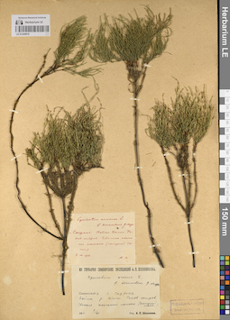
LE 01245010
Equisetum arvense L. f. decumbens G.F.W. Meyer det. Schennikov, Alexander Petrovich
Collectors: Schennikov, Alexander Petrovich Field collecting number: s.n. Collection date: 08.07.1916. Administrative regions: RU - Samarskaya Oblast' - Syzranskiy Rayon. Place of collection: Сызранский у. г. Сызрань. Пойма р. Волга. Раков остров. Свежие песчаные наносы (сыпучий песок).Expedition: Из гербария симбирских экспедиций А. П. Шенникова (1916)Groups of specimens: Образцы сектора Восточной Европы; Флора Урала и прилегающих территорий (проект); Соглашение Минобрнауки №075-15-2021-1056Original label text:[1]Equisetum arvense L. f. decumbens G. Meyer. г. Сызрань. Пойма Волги. Раков остров. Светлые песчаные полосы (сыпучий песок). 8.VII.1916. А.Ш. [2] Из гербария симбирских экспедиций А.П. Шенникова. Equisetum arvense L. f. decumbens G. Meyer. Сызранский у. г. Сызрань. Пойма р. Волги. Раков остров. Свежие песчаные наносы (сыпучий песок.). 1916 8/VII. Опр. А.П. Шенников
Landscape in location of collection: пойма р. Волга, островSubstrate in collecting location: свежие песчаные наносы (сыпучий песок)Coordinates (geographic position): 53° 8′ 30.38″ N, 48° 30′ 29.61″ E ±10000 mRecord creation: 2023-07-17, Denis Melnikov, PhotoScan D2.Citation: Specimen LE 01245010 // Virtual herbarium of Komarov Botanical Institute RAS — http://re.herbariumle.ru/01245010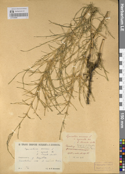
LE 01245009
Equisetum arvense L. var. agreste Klinge f. boreale Milde det. Schennikov, Alexander Petrovich
Collectors: Schennikov, Alexander Petrovich Field collecting number: s.n. Collection date: 16.07.1916. Administrative regions: RU - Ulyanovsk Oblast - Radishchevskiy Rayon. Place of collection: Сызранский у. д. Вязовка. Осокоревый лес в пойме р. Волга.Expedition: Из гербария симбирских экспедиций А. П. Шенникова (1916)Groups of specimens: Образцы сектора Восточной Европы; Флора Урала и прилегающих территорий (проект); Соглашение Минобрнауки №075-15-2021-1056Original label text:Из гербария симбирских экспедиций А.П. Шенникова. Equisetum arvense L. v. agreste Kl. f. boreale Milde. Сызранский у. д. Вязовка. Осокоревый лес в пойме Волги. 16.VII.1916. Опр. А.П. Шенников
Landscape in location of collection: пойма реки ВолгаHabitat / plant community in location of collecting: осокоревый лесCoordinates (geographic position): 52° 51′ 7.04″ N, 48° 22′ 28.41″ E ±2000 mRecord creation: 2023-07-17, Denis Melnikov, PhotoScan D2.Citation: Specimen LE 01245009 // Virtual herbarium of Komarov Botanical Institute RAS — http://re.herbariumle.ru/01245009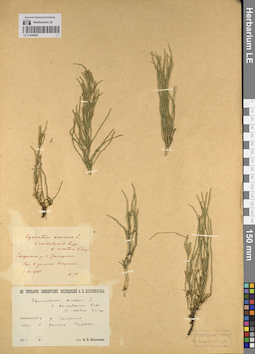
LE 01245008
Equisetum arvense L. var. ramulosum Rupr. f. erectum Klinge det. Schennikov, Alexander Petrovich
Collectors: Schennikov, Alexander Petrovich Field collecting number: s.n. Collection date: 01.06.1915. Administrative regions: RU - Ulyanovsk Oblast - Baryshskiy Rayon. Place of collection: Сызранский у. д. Загорино. Луг в долине р. Сызранка.Expedition: Из гербария симбирских экспедиций А. П. Шенникова (1916)Groups of specimens: Образцы сектора Восточной Европы; Флора Урала и прилегающих территорий (проект); Соглашение Минобрнауки №075-15-2021-1056Original label text:[1]Equisetum arvense L. v. ramulosum Rupr. f. erectum Klinge. Сызранск. у., д. Загарино. Луг в долине Сызрана. 1.VI.1915. А. Т. [2] Из гербария симбирских экспедиций А.П. Шенникова. Equisetum arvense L. v. ramulosum Rupr. f. erectum Klinge. Сызранский у. д. Загорино. Луг в долине Сызрана. 1915 1/VI. Опр. А.П. Шенников
Landscape in location of collection: луг в долине рекиHabitat / plant community in location of collecting: лугCoordinates (geographic position): 53° 25′ 5.01″ N, 47° 15′ 11.1″ E ±4000 mRecord creation: 2023-07-17, Denis Melnikov, PhotoScan D2.Citation: Specimen LE 01245008 // Virtual herbarium of Komarov Botanical Institute RAS — http://re.herbariumle.ru/01245008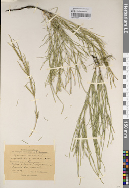
LE 01245007
Equisetum arvense L. var. agreste Klinge f. boreale Milde det. Schennikov, Alexander Petrovich
Collectors: Schennikov, Alexander Petrovich Field collecting number: s.n. Collection date: 29.07.1914. Administrative regions: RU - Ulyanovsk Oblast - Ulyanovskiy Rayon. Subregion: городской округ Новоульяновск. Place of collection: Ульяновский уезд. с. Криуши. Пойма р. Волга, островной луг. Береговой вал, песчаный.Expedition: Ульяновская губерния. Из гербария Экспедиции А.П. Шенникова (1914 -1919)Groups of specimens: Образцы сектора Восточной Европы; Флора Урала и прилегающих территорий (проект); Соглашение Минобрнауки №075-15-2021-1056Original label text:Ульяновская губерния. Из гербария Экспедиции А.П. Шенникова. Equisetum arvense L. v. agreste Kl. f. boreale Milde. Ульяновский уезд. с. Криуши. Пойма р. Волги, островной луг. Береговой вал, песчаный. 1914.VII.29. нов. ст. Опр. А.П. Шенников. Plantae gub. Uljanowsk
Landscape in location of collection: пойма реки Волга, береговой вал, песчаныйHabitat / plant community in location of collecting: островной лугSubstrate in collecting location: песокCoordinates (geographic position): 54° 6′ 16.28″ N, 48° 31′ 54.99″ E ±3000 mRecord creation: 2023-07-17, Denis Melnikov, PhotoScan D2.Citation: Specimen LE 01245007 // Virtual herbarium of Komarov Botanical Institute RAS — http://re.herbariumle.ru/01245007