View
Add
Copy
Edit
Delete
LE 01247134
Schoberia pterantha Kar. & Kir.
Additional identifications: Suaeda corniculata (C.A. Mey.) Bunge Groups of specimens: Образцы сектора Средней Азии; Типовые образцы сектора Средней Азии; Соглашение Минобрнауки №075-15-2021-1056Record creation: 2023-07-24, Mariya Sheludyakova, PhotoScan D2.Citation: Specimen LE 01247134 // Virtual herbarium of Komarov Botanical Institute RAS — http://re.herbariumle.ru/01247134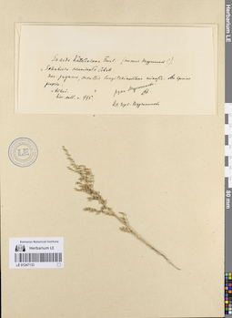
LE 01247133
Schoberia pterantha Kar. & Kir.
Additional identifications: Schoberia acuminata C. A. Mey Groups of specimens: Образцы сектора Средней Азии; Типовые образцы сектора Средней Азии; Соглашение Минобрнауки №075-15-2021-1056Record creation: 2023-07-24, Mariya Sheludyakova, PhotoScan D2.Citation: Specimen LE 01247133 // Virtual herbarium of Komarov Botanical Institute RAS — http://re.herbariumle.ru/01247133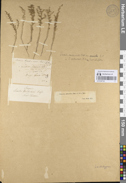
LE 01247132
Schoberia pterantha Kar. & Kir.
Additional identifications: Suaeda pterantha (Kar. & Kir.) Bunge Groups of specimens: Образцы сектора Средней Азии; Типовые образцы сектора Средней Азии; Соглашение Минобрнауки №075-15-2021-1056Record creation: 2023-07-24, Mariya Sheludyakova, PhotoScan D2.Citation: Specimen LE 01247132 // Virtual herbarium of Komarov Botanical Institute RAS — http://re.herbariumle.ru/01247132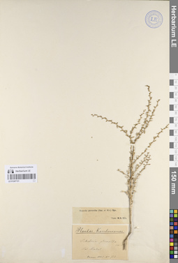
LE 01247131
Schoberia pterantha Kar. & Kir.
Additional identifications: Suaeda pterantha (Kar. & Kir.) Bunge Groups of specimens: Образцы сектора Средней Азии; Типовые образцы сектора Средней Азии; Соглашение Минобрнауки №075-15-2021-1056Record creation: 2023-07-24, Mariya Sheludyakova, PhotoScan D2.Citation: Specimen LE 01247131 // Virtual herbarium of Komarov Botanical Institute RAS — http://re.herbariumle.ru/01247131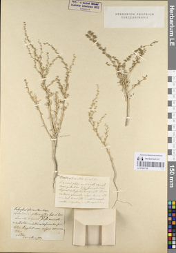
LE 01247130
Schoberia pterantha Kar. & Kir.
Groups of specimens: Образцы сектора Средней Азии; Типовые образцы сектора Средней Азии; Соглашение Минобрнауки №075-15-2021-1056Record creation: 2023-07-24, Mariya Sheludyakova, PhotoScan D2.Citation: Specimen LE 01247130 // Virtual herbarium of Komarov Botanical Institute RAS — http://re.herbariumle.ru/01247130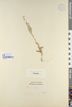
LE 01247129
Schoberia obtusifolia Bge.
Groups of specimens: Образцы сектора Средней Азии; Типовые образцы сектора Средней Азии; Соглашение Минобрнауки №075-15-2021-1056Record creation: 2023-07-24, Mariya Sheludyakova, PhotoScan D2.Citation: Specimen LE 01247129 // Virtual herbarium of Komarov Botanical Institute RAS — http://re.herbariumle.ru/01247129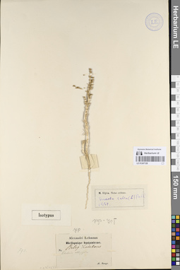
LE 01247128
Schoberia obtusifolia Bge.
Additional identifications: Suaeda salsa (L.) Pall. Groups of specimens: Образцы сектора Средней Азии; Типовые образцы сектора Средней Азии; Соглашение Минобрнауки №075-15-2021-1056Record creation: 2023-07-24, Mariya Sheludyakova, PhotoScan D2.Citation: Specimen LE 01247128 // Virtual herbarium of Komarov Botanical Institute RAS — http://re.herbariumle.ru/01247128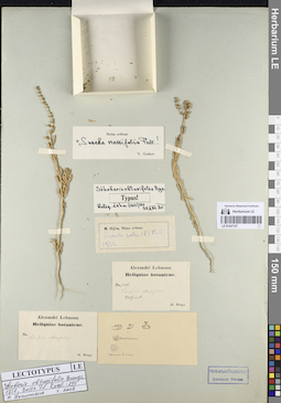
LE 01247127
Schoberia obtusifolia Bge.
Additional identifications: Suaeda crassifolia Pall. Groups of specimens: Образцы сектора Средней Азии; Типовые образцы сектора Средней Азии; Соглашение Минобрнауки №075-15-2021-1056Record creation: 2023-07-24, Mariya Sheludyakova, PhotoScan D2.Citation: Specimen LE 01247127 // Virtual herbarium of Komarov Botanical Institute RAS — http://re.herbariumle.ru/01247127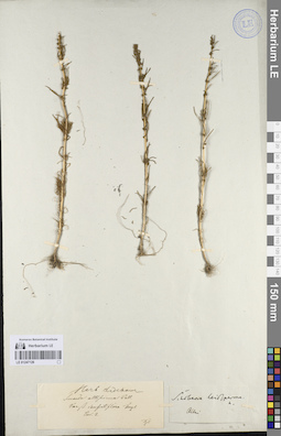
LE 01247126
Schoberia leiosperma C.A. Mey.
Groups of specimens: Образцы сектора Средней Азии; Типовые образцы сектора Средней Азии; Соглашение Минобрнауки №075-15-2021-1056Record creation: 2023-07-24, Mariya Sheludyakova, PhotoScan D2.Citation: Specimen LE 01247126 // Virtual herbarium of Komarov Botanical Institute RAS — http://re.herbariumle.ru/01247126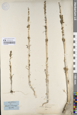
LE 01247125
Schoberia leiosperma C.A. Mey.
Groups of specimens: Образцы сектора Средней Азии; Типовые образцы сектора Средней Азии; Соглашение Минобрнауки №075-15-2021-1056Record creation: 2023-07-24, Mariya Sheludyakova, PhotoScan D2.Citation: Specimen LE 01247125 // Virtual herbarium of Komarov Botanical Institute RAS — http://re.herbariumle.ru/01247125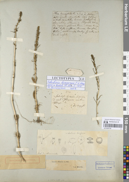
LE 01247124
Schoberia leiosperma C.A. Mey.
Additional identifications: Suaeda altissima (L.) Pall. Groups of specimens: Образцы сектора Средней Азии; Типовые образцы сектора Средней Азии; Соглашение Минобрнауки №075-15-2021-1056Record creation: 2023-07-24, Mariya Sheludyakova, PhotoScan D2.Citation: Specimen LE 01247124 // Virtual herbarium of Komarov Botanical Institute RAS — http://re.herbariumle.ru/01247124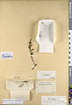
LE 01247123
Schoberia inderiensis Bge.
Additional identifications: Suaeda altissima (L.) Pall. Groups of specimens: Образцы сектора Средней Азии; Типовые образцы сектора Средней Азии; Соглашение Минобрнауки №075-15-2021-1056Record creation: 2023-07-24, Mariya Sheludyakova, PhotoScan D2.Citation: Specimen LE 01247123 // Virtual herbarium of Komarov Botanical Institute RAS — http://re.herbariumle.ru/01247123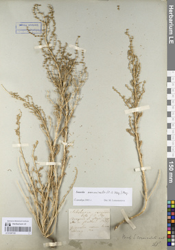
LE 01247122
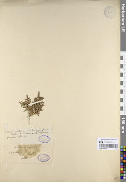
Schoberia corniculata C. A. Mey.
Additional identifications: Suaeda acuminata (C.A. Mey.) Moq. Groups of specimens: Образцы сектора Средней Азии; Типовые образцы сектора Средней Азии; Соглашение Минобрнауки №075-15-2021-1056Record creation: 2023-07-24, Mariya Sheludyakova, PhotoScan D2.Citation: Specimen LE 01247122 // Virtual herbarium of Komarov Botanical Institute RAS — http://re.herbariumle.ru/01247122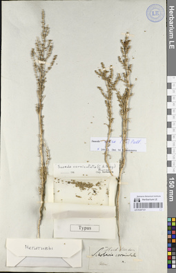
LE 01247121
Schoberia corniculata C. A. Mey.
Additional identifications: Suaeda corniculata (C.A. Mey.) Bunge Groups of specimens: Образцы сектора Средней Азии; Типовые образцы сектора Средней Азии; Соглашение Минобрнауки №075-15-2021-1056Record creation: 2023-07-24, Mariya Sheludyakova, PhotoScan D2.Citation: Specimen LE 01247121 // Virtual herbarium of Komarov Botanical Institute RAS — http://re.herbariumle.ru/01247121
LE 01247119
Schoberia corniculata C. A. Mey.
Groups of specimens: Образцы сектора Средней Азии; Типовые образцы сектора Средней Азии; Соглашение Минобрнауки №075-15-2021-1056Record creation: 2023-07-24, Mariya Sheludyakova, PhotoScan D2.Citation: Specimen LE 01247119 // Virtual herbarium of Komarov Botanical Institute RAS — http://re.herbariumle.ru/01247119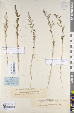
LE 01247120
Schoberia corniculata C. A. Mey.
Groups of specimens: Образцы сектора Средней Азии; Типовые образцы сектора Средней Азии; Соглашение Минобрнауки №075-15-2021-1056Record creation: 2023-07-24, Mariya Sheludyakova, PhotoScan D2.Citation: Specimen LE 01247120 // Virtual herbarium of Komarov Botanical Institute RAS — http://re.herbariumle.ru/01247120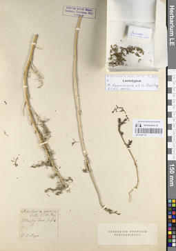
LE 01247118
Schoberia corniculata C. A. Mey.
Groups of specimens: Образцы сектора Средней Азии; Типовые образцы сектора Средней Азии; Соглашение Минобрнауки №075-15-2021-1056Record creation: 2023-07-24, Mariya Sheludyakova, PhotoScan D2.Citation: Specimen LE 01247118 // Virtual herbarium of Komarov Botanical Institute RAS — http://re.herbariumle.ru/01247118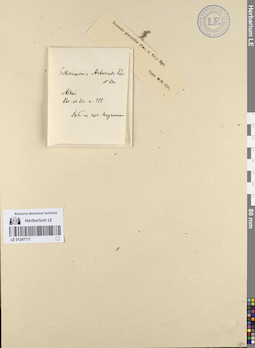
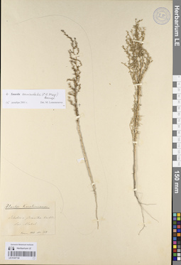
LE 01247117
Schanginia arbuscula Kar. & Kir.
Additional identifications: Suaeda pterantha (Kar. & Kir.) Bunge Groups of specimens: Образцы сектора Средней Азии; Типовые образцы сектора Средней Азии; Соглашение Минобрнауки №075-15-2021-1056Record creation: 2023-07-24, Mariya Sheludyakova, PhotoScan D2.Citation: Specimen LE 01247117 // Virtual herbarium of Komarov Botanical Institute RAS — http://re.herbariumle.ru/01247117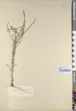
LE 01247116
Schanginia arbuscula Kar. & Kir.
Additional identifications: Schoberia pterantha Kar. & Kir. Groups of specimens: Образцы сектора Средней Азии; Типовые образцы сектора Средней Азии; Соглашение Минобрнауки №075-15-2021-1056Record creation: 2023-07-24, Mariya Sheludyakova, PhotoScan D2.Citation: Specimen LE 01247116 // Virtual herbarium of Komarov Botanical Institute RAS — http://re.herbariumle.ru/01247116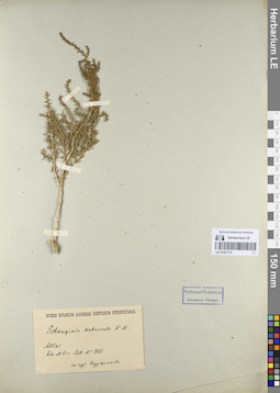
LE 01247115
Schanginia arbuscula Kar. & Kir.
Groups of specimens: Образцы сектора Средней Азии; Типовые образцы сектора Средней Азии; Соглашение Минобрнауки №075-15-2021-1056Record creation: 2023-07-24, Mariya Sheludyakova, PhotoScan D2.Citation: Specimen LE 01247115 // Virtual herbarium of Komarov Botanical Institute RAS — http://re.herbariumle.ru/01247115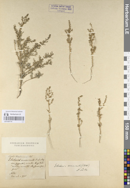
LE 01247114
Schanginia arbuscula Kar. & Kir.
Additional identifications: Schoberia acuminata C. A. Mey Groups of specimens: Образцы сектора Средней Азии; Типовые образцы сектора Средней Азии; Соглашение Минобрнауки №075-15-2021-1056Record creation: 2023-07-24, Mariya Sheludyakova, PhotoScan D2.Citation: Specimen LE 01247114 // Virtual herbarium of Komarov Botanical Institute RAS — http://re.herbariumle.ru/01247114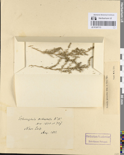
LE 01247113
Schanginia arbuscula Kar. & Kir.
Additional identifications: Suaeda pterantha (Kar. & Kir.) Bunge Groups of specimens: Образцы сектора Средней Азии; Типовые образцы сектора Средней Азии; Соглашение Минобрнауки №075-15-2021-1056Record creation: 2023-07-24, Mariya Sheludyakova, PhotoScan D2.Citation: Specimen LE 01247113 // Virtual herbarium of Komarov Botanical Institute RAS — http://re.herbariumle.ru/01247113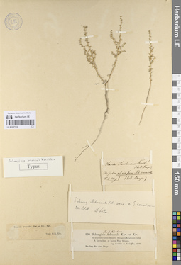
LE 01247112
Schanginia arbuscula Kar. & Kir.
Additional identifications: Suaeda pterantha (Kar. & Kir.) Bunge Groups of specimens: Образцы сектора Средней Азии; Типовые образцы сектора Средней Азии; Соглашение Минобрнауки №075-15-2021-1056Record creation: 2023-07-24, Mariya Sheludyakova, PhotoScan D2.Citation: Specimen LE 01247112 // Virtual herbarium of Komarov Botanical Institute RAS — http://re.herbariumle.ru/01247112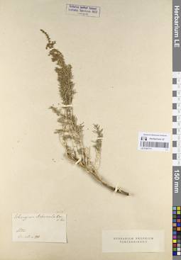
LE 01247111
Schanginia arbuscula Kar. & Kir.
Groups of specimens: Образцы сектора Средней Азии; Типовые образцы сектора Средней Азии; Соглашение Минобрнауки №075-15-2021-1056Record creation: 2023-07-24, Mariya Sheludyakova, PhotoScan D2.Citation: Specimen LE 01247111 // Virtual herbarium of Komarov Botanical Institute RAS — http://re.herbariumle.ru/01247111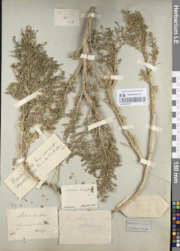
LE 01247110
Schoberia cycloptera Bunge ex Trautv.
Groups of specimens: Образцы сектора Средней Азии; Типовые образцы сектора Средней Азии; Соглашение Минобрнауки №075-15-2021-1056Record creation: 2023-07-24, Mariya Sheludyakova, PhotoScan D2.Citation: Specimen LE 01247110 // Virtual herbarium of Komarov Botanical Institute RAS — http://re.herbariumle.ru/01247110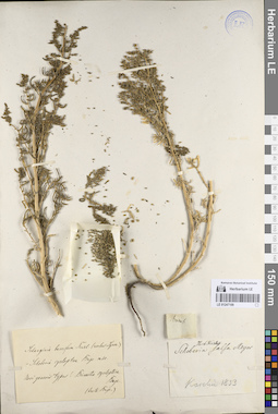
LE 01247109
Schoberia cycloptera Bunge ex Trautv.
Groups of specimens: Образцы сектора Средней Азии; Типовые образцы сектора Средней Азии; Соглашение Минобрнауки №075-15-2021-1056Record creation: 2023-07-24, Mariya Sheludyakova, PhotoScan D2.Citation: Specimen LE 01247109 // Virtual herbarium of Komarov Botanical Institute RAS — http://re.herbariumle.ru/01247109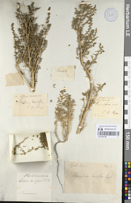
LE 01247108
Schoberia cycloptera Bunge ex Trautv.
Additional identifications: Schoberia baccifera C.A.Mey. Groups of specimens: Образцы сектора Средней Азии; Типовые образцы сектора Средней Азии; Соглашение Минобрнауки №075-15-2021-1056Record creation: 2023-07-24, Mariya Sheludyakova, PhotoScan D2.Citation: Specimen LE 01247108 // Virtual herbarium of Komarov Botanical Institute RAS — http://re.herbariumle.ru/01247108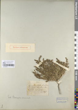
LE 01247107
Schoberia acuminata C. A. Mey
Groups of specimens: Образцы сектора Средней Азии; Типовые образцы сектора Средней Азии; Соглашение Минобрнауки №075-15-2021-1056Record creation: 2023-07-24, Mariya Sheludyakova, PhotoScan D2.Citation: Specimen LE 01247107 // Virtual herbarium of Komarov Botanical Institute RAS — http://re.herbariumle.ru/01247107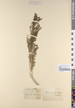
LE 01247106
Schoberia acuminata C. A. Mey
Groups of specimens: Образцы сектора Средней Азии; Типовые образцы сектора Средней Азии; Соглашение Минобрнауки №075-15-2021-1056Record creation: 2023-07-24, Mariya Sheludyakova, PhotoScan D2.Citation: Specimen LE 01247106 // Virtual herbarium of Komarov Botanical Institute RAS — http://re.herbariumle.ru/01247106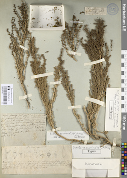
LE 01247105
Schoberia acuminata C. A. Mey
Groups of specimens: Образцы сектора Средней Азии; Типовые образцы сектора Средней Азии; Соглашение Минобрнауки №075-15-2021-1056Record creation: 2023-07-24, Mariya Sheludyakova, PhotoScan D2.Citation: Specimen LE 01247105 // Virtual herbarium of Komarov Botanical Institute RAS — http://re.herbariumle.ru/01247105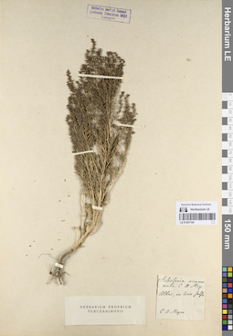
LE 01247104
Schoberia acuminata C. A. Mey
Groups of specimens: Образцы сектора Средней Азии; Типовые образцы сектора Средней Азии; Соглашение Минобрнауки №075-15-2021-1056Record creation: 2023-07-24, Mariya Sheludyakova, PhotoScan D2.Citation: Specimen LE 01247104 // Virtual herbarium of Komarov Botanical Institute RAS — http://re.herbariumle.ru/01247104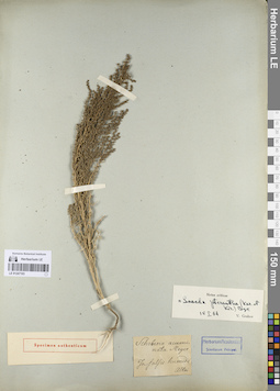
LE 01247103
Schoberia acuminata C. A. Mey
Additional identifications: Suaeda pterantha (Kar. & Kir.) Bunge Groups of specimens: Образцы сектора Средней Азии; Типовые образцы сектора Средней Азии; Соглашение Минобрнауки №075-15-2021-1056Record creation: 2023-07-24, Mariya Sheludyakova, PhotoScan D2.Citation: Specimen LE 01247103 // Virtual herbarium of Komarov Botanical Institute RAS — http://re.herbariumle.ru/01247103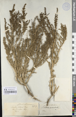
LE 01247102
Schoberia acuminata C. A. Mey
Groups of specimens: Образцы сектора Средней Азии; Типовые образцы сектора Средней Азии; Соглашение Минобрнауки №075-15-2021-1056Record creation: 2023-07-24, Mariya Sheludyakova, PhotoScan D2.Citation: Specimen LE 01247102 // Virtual herbarium of Komarov Botanical Institute RAS — http://re.herbariumle.ru/01247102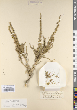
LE 01247101
Salicornia strobilacea Pall.
Groups of specimens: Образцы сектора Средней Азии; Типовые образцы сектора Средней Азии; Соглашение Минобрнауки №075-15-2021-1056Record creation: 2023-07-24, Mariya Sheludyakova, PhotoScan D2.Citation: Specimen LE 01247101 // Virtual herbarium of Komarov Botanical Institute RAS — http://re.herbariumle.ru/01247101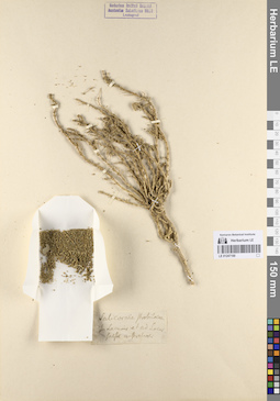
LE 01247100
Salicornia strobilacea Pall.
Groups of specimens: Образцы сектора Средней Азии; Типовые образцы сектора Средней Азии; Соглашение Минобрнауки №075-15-2021-1056Record creation: 2023-07-24, Mariya Sheludyakova, PhotoScan D2.Citation: Specimen LE 01247100 // Virtual herbarium of Komarov Botanical Institute RAS — http://re.herbariumle.ru/01247100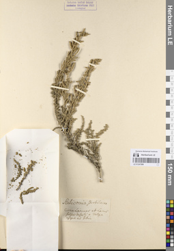
LE 01247099
Salicornia strobilacea Pall.
Groups of specimens: Образцы сектора Средней Азии; Типовые образцы сектора Средней Азии; Соглашение Минобрнауки №075-15-2021-1056Record creation: 2023-07-24, Mariya Sheludyakova, PhotoScan D2.Citation: Specimen LE 01247099 // Virtual herbarium of Komarov Botanical Institute RAS — http://re.herbariumle.ru/01247099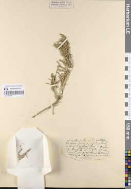
LE 01247098
Salicornia strobilacea Pall.
Groups of specimens: Образцы сектора Средней Азии; Типовые образцы сектора Средней Азии; Соглашение Минобрнауки №075-15-2021-1056Record creation: 2023-07-24, Mariya Sheludyakova, PhotoScan D2.Citation: Specimen LE 01247098 // Virtual herbarium of Komarov Botanical Institute RAS — http://re.herbariumle.ru/01247098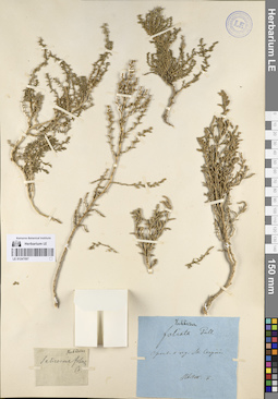
LE 01247097
Salicornia foliata Pall.
Groups of specimens: Образцы сектора Средней Азии; Типовые образцы сектора Средней Азии; Соглашение Минобрнауки №075-15-2021-1056Record creation: 2023-07-24, Mariya Sheludyakova, PhotoScan D2.Citation: Specimen LE 01247097 // Virtual herbarium of Komarov Botanical Institute RAS — http://re.herbariumle.ru/01247097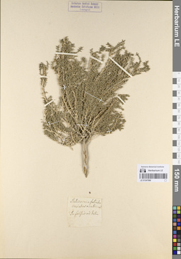
LE 01247096
Salicornia foliata Pall.
Groups of specimens: Образцы сектора Средней Азии; Типовые образцы сектора Средней Азии; Соглашение Минобрнауки №075-15-2021-1056Record creation: 2023-07-24, Mariya Sheludyakova, PhotoScan D2.Citation: Specimen LE 01247096 // Virtual herbarium of Komarov Botanical Institute RAS — http://re.herbariumle.ru/01247096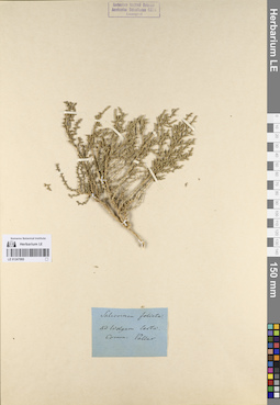
LE 01247095
Salicornia foliata Pall.
Groups of specimens: Образцы сектора Средней Азии; Типовые образцы сектора Средней Азии; Соглашение Минобрнауки №075-15-2021-1056Record creation: 2023-07-24, Mariya Sheludyakova, PhotoScan D2.Citation: Specimen LE 01247095 // Virtual herbarium of Komarov Botanical Institute RAS — http://re.herbariumle.ru/01247095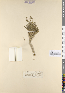
LE 01247094
Salicornia foliata Pall.
Groups of specimens: Образцы сектора Средней Азии; Типовые образцы сектора Средней Азии; Соглашение Минобрнауки №075-15-2021-1056Record creation: 2023-07-24, Mariya Sheludyakova, PhotoScan D2.Citation: Specimen LE 01247094 // Virtual herbarium of Komarov Botanical Institute RAS — http://re.herbariumle.ru/01247094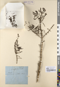
LE 01247093
Salicornia caspica Pall.
Groups of specimens: Образцы сектора Средней Азии; Типовые образцы сектора Средней Азии; Соглашение Минобрнауки №075-15-2021-1056Record creation: 2023-07-24, Mariya Sheludyakova, PhotoScan D2.Citation: Specimen LE 01247093 // Virtual herbarium of Komarov Botanical Institute RAS — http://re.herbariumle.ru/01247093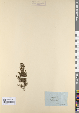
LE 01247092
Salicornia caspica Pall.
Groups of specimens: Образцы сектора Средней Азии; Типовые образцы сектора Средней Азии; Соглашение Минобрнауки №075-15-2021-1056Record creation: 2023-07-24, Mariya Sheludyakova, PhotoScan D2.Citation: Specimen LE 01247092 // Virtual herbarium of Komarov Botanical Institute RAS — http://re.herbariumle.ru/01247092
LE 01247090
Halostachys songarica Schrenk
Groups of specimens: Образцы сектора Средней Азии; Типовые образцы сектора Средней Азии; Соглашение Минобрнауки №075-15-2021-1056Record creation: 2023-07-24, Mariya Sheludyakova, PhotoScan D2.Citation: Specimen LE 01247090 // Virtual herbarium of Komarov Botanical Institute RAS — http://re.herbariumle.ru/01247090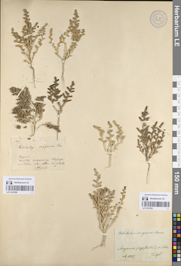
LE 01247091
Halostachys songarica Schrenk
Groups of specimens: Образцы сектора Средней Азии; Типовые образцы сектора Средней Азии; Соглашение Минобрнауки №075-15-2021-1056Record creation: 2023-07-24, Mariya Sheludyakova, PhotoScan D2.Citation: Specimen LE 01247091 // Virtual herbarium of Komarov Botanical Institute RAS — http://re.herbariumle.ru/01247091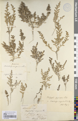
LE 01247089
Halostachys songarica Schrenk
Groups of specimens: Образцы сектора Средней Азии; Типовые образцы сектора Средней Азии; Соглашение Минобрнауки №075-15-2021-1056Record creation: 2023-07-24, Mariya Sheludyakova, PhotoScan D2.Citation: Specimen LE 01247089 // Virtual herbarium of Komarov Botanical Institute RAS — http://re.herbariumle.ru/01247089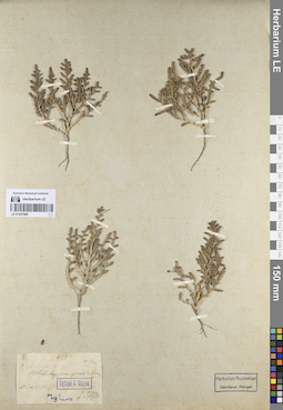
LE 01247088
Halostachys songarica Schrenk
Groups of specimens: Образцы сектора Средней Азии; Типовые образцы сектора Средней Азии; Соглашение Минобрнауки №075-15-2021-1056Record creation: 2023-07-24, Mariya Sheludyakova, PhotoScan D2.Citation: Specimen LE 01247088 // Virtual herbarium of Komarov Botanical Institute RAS — http://re.herbariumle.ru/01247088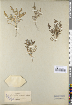
LE 01247087
Halostachys songarica Schrenk
Groups of specimens: Образцы сектора Средней Азии; Типовые образцы сектора Средней Азии; Соглашение Минобрнауки №075-15-2021-1056Record creation: 2023-07-24, Mariya Sheludyakova, PhotoScan D2.Citation: Specimen LE 01247087 // Virtual herbarium of Komarov Botanical Institute RAS — http://re.herbariumle.ru/01247087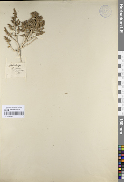
LE 01247086
Halostachys songarica Schrenk
Groups of specimens: Образцы сектора Средней Азии; Типовые образцы сектора Средней Азии; Соглашение Минобрнауки №075-15-2021-1056Record creation: 2023-07-24, Mariya Sheludyakova, PhotoScan D2.Citation: Specimen LE 01247086 // Virtual herbarium of Komarov Botanical Institute RAS — http://re.herbariumle.ru/01247086