View
Add
Copy
Edit
Delete
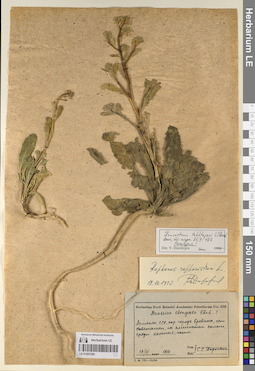
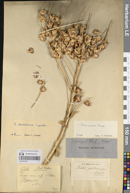
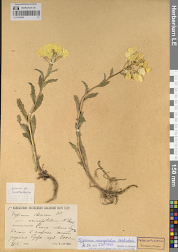
LE 01207280
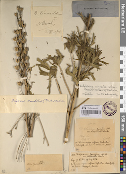
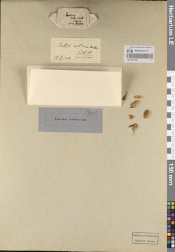
Additional identifications: Brassica elongata Ehrh. det. Kharkevich, Sigismund Semenovich at 17.06.1957; Erucastrum takhtajanii V.I. Dorof. det. Dorofeyev, Vladimir Ivanovich at 2000; Raphanus raphanistrum L. det. Dorofeyev, Vladimir Ivanovich at 19.10.1992 Collectors: Kharkevich, Sigismund Semenovich Collection date: 17.06.1957. Administrative regions: AM - Armenia. Place of collection: окр. города Еревана, с. Советашен.Groups of specimens: Образцы сектора Кавказа; Типовые образцы сектора Кавказа; Соглашение Минобрнауки №075-15-2021-1056Original label text:
Herbarium Horti Botanici Academiae Sсientiarum Ucr. SSR
Brassica elongata Ehrh. ?
Армянская ССР, окр. города Еревана, с. Советашен, на глинистом склоне, среди камней, часто.
17.6.1957
Leg. et det. С. С. Харкевич
Erucastrum takhtajanii V.I. Dorof
2000, Бот. журн.85,7 : 183
Paratypus!
Det. V. Dorofeyev 2000
Raphanus raphanistrum L. 19.10.1992 В. Дорофеев
Habitat / plant community in location of collecting: на глинистом склоне, среди камней, часто.Record creation: 2023-07-28, Elena Portenier, PhotoScan D2.Citation: Specimen LE 01207280 // Virtual herbarium of Komarov Botanical Institute RAS — http://re.herbariumle.ru/01207280Brassica elongata Ehrh. ?
Армянская ССР, окр. города Еревана, с. Советашен, на глинистом склоне, среди камней, часто.
17.6.1957
Leg. et det. С. С. Харкевич
Erucastrum takhtajanii V.I. Dorof
2000, Бот. журн.85,7 : 183
Paratypus!
Det. V. Dorofeyev 2000
Raphanus raphanistrum L. 19.10.1992 В. Дорофеев
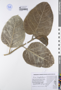
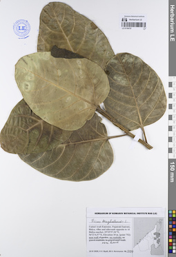
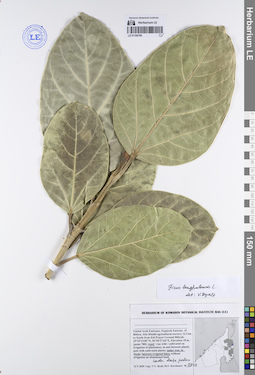
LE 01194759
Ficus benghalensis L. det. Byalt, Vyacheslav Vyacheslavovich
Administrative regions: AE - United Arab Emirates. Groups of specimens: Образцы общего сектора; Соглашение Минобрнауки №075-15-2021-1056; Бялт В.В.: Флора ФуджейрыRecord creation: 2023-07-31, Larisa Orlova, PhotoScan D2.Citation: Specimen LE 01194759 // Virtual herbarium of Komarov Botanical Institute RAS — http://re.herbariumle.ru/01194759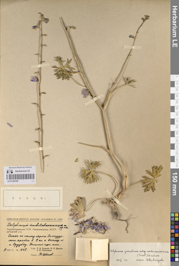
LE 01220158
Groups of specimens: Образцы сектора Кавказа; Типовые образцы сектора Кавказа; Соглашение Минобрнауки №075-15-2021-1056Record creation: 2023-07-26, Elena Portenier, PhotoScan D2.Citation: Specimen LE 01220158 // Virtual herbarium of Komarov Botanical Institute RAS — http://re.herbariumle.ru/01220158
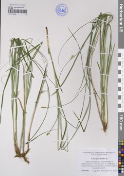
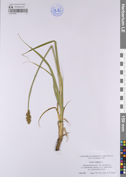
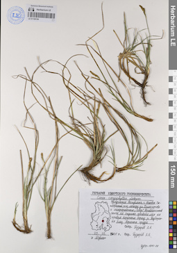
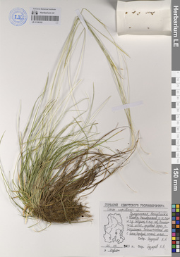
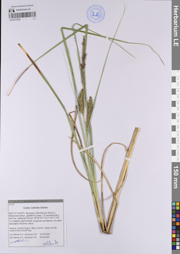
LE 01174186
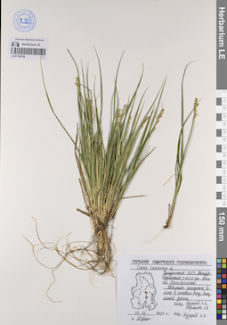
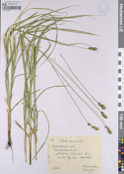
Carex brizoides L. det. Konechnaya, Galina Yurievna, Haare, Ado Oskarovich at 15.06.1992
Collectors: Konechnaya, Galina Yurievna; Haare, Ado Oskarovich Collection date: 15.06.1992. Administrative regions: RU - Leningradskaya Oblast' - Kirishskiy Rayon. Groups of specimens: Образцы сектора Восточной Европы; Соглашение Минобрнауки №075-15-2021-1056Original label text:Ленинградская область, Киришский район, окрестности станции Посадниково, от платформы в сторону Малуксы, на лужайке с южной стороны железной дороги.
Coordinates (geographic position): 59° 28′ 19.66″ N, 31° 53′ 47.09″ E ±1000 mRecord creation: 2023-07-26, Artyom Borodushkin, PhotoScan D2.Citation: Specimen LE 01174186 // Virtual herbarium of Komarov Botanical Institute RAS — http://re.herbariumle.ru/01174186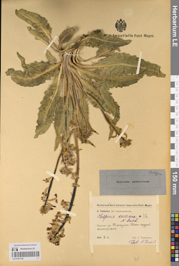
LE 01221134
Groups of specimens: Образцы сектора Кавказа; Типовые образцы сектора Кавказа; Соглашение Минобрнауки №075-15-2021-1056Record creation: 2023-07-31, Elena Portenier, PhotoScan D2.Citation: Specimen LE 01221134 // Virtual herbarium of Komarov Botanical Institute RAS — http://re.herbariumle.ru/01221134
LE 01221190
Groups of specimens: Образцы сектора Кавказа; Типовые образцы сектора Кавказа; Соглашение Минобрнауки №075-15-2021-1056Record creation: 2023-08-01, Elena Portenier, PhotoScan D2.Citation: Specimen LE 01221190 // Virtual herbarium of Komarov Botanical Institute RAS — http://re.herbariumle.ru/01221190
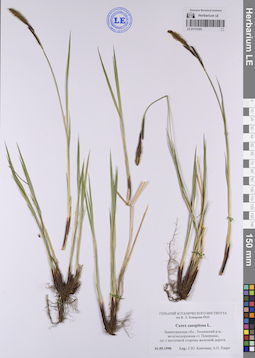
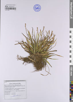
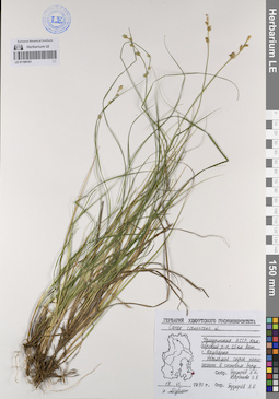
LE 01106195
Carex caryophyllea Latourr. det. Pusyrev, Alexander Nikolaevich at 03.04.1986
Collectors: Pusyrev, Alexander Nikolaevich Collection date: 03.04.1986. Administrative regions: RU - Udmurtskaya Respublika - Izhevsk. Groups of specimens: Образцы сектора Восточной Европы; Соглашение Минобрнауки №075-15-2021-1056; Гербарий Удмуртского Госуниверситета.; Флора Урала и прилегающих территорий (проект)Original label text:Удмуртская АССР, город Ижевск (восточная окраина), Первомайский район, между 43 и 44 км железной дороги Агрыз - Ижевск - Воткинск. Травянистый склон южной экспозиции, недалеко от железнодорожной насыпи садоогородов.
Coordinates (geographic position): 56° 49′ 49.49″ N, 53° 17′ 12.88″ E ±1500 mRecord creation: 2023-07-27, Artyom Borodushkin, PhotoScan D2.Citation: Specimen LE 01106195 // Virtual herbarium of Komarov Botanical Institute RAS — http://re.herbariumle.ru/01106195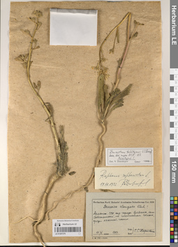
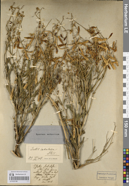
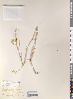
LE 01207279
Erucastrum takhtajanii V.I. Dorof. det. Dorofeyev, Vladimir Ivanovich at 2000
Additional identifications: Brassica elongata Ehrh. det. Kharkevich, Sigismund Semenovich at 17.06.1957; Raphanus raphanistrum L. det. Dorofeyev, Vladimir Ivanovich at 19.10.1992 Collectors: Kharkevich, Sigismund Semenovich Collection date: 17.06.1957. Administrative regions: AM - Armenia. Place of collection: окр. города Еревана, с. Советашен.Groups of specimens: Образцы сектора Кавказа; Типовые образцы сектора Кавказа; Соглашение Минобрнауки №075-15-2021-1056Original label text:Herbarium Horti Botanici Academiae Sсientiarum Ucr. SSR
Brassica elongata Ehrh. ?
Армянская ССР, окр. города Еревана, с. Советашен, на глинистом склоне, среди камней, часто.
17.6.1957
Leg. et det. С. С. Харкевич
Erucastrum takhtajanii V.I. Dorof
2000, Бот. журн.85,7 : 183
Paratypus!
Det. V. Dorofeyev 2000
Raphanus raphanistrum L. 19.10.1992 В. Дорофеев
Habitat / plant community in location of collecting: на глинистом склоне, среди камней, частоRecord creation: 2023-07-28, Elena Portenier, PhotoScan D2.Citation: Specimen LE 01207279 // Virtual herbarium of Komarov Botanical Institute RAS — http://re.herbariumle.ru/01207279Brassica elongata Ehrh. ?
Армянская ССР, окр. города Еревана, с. Советашен, на глинистом склоне, среди камней, часто.
17.6.1957
Leg. et det. С. С. Харкевич
Erucastrum takhtajanii V.I. Dorof
2000, Бот. журн.85,7 : 183
Paratypus!
Det. V. Dorofeyev 2000
Raphanus raphanistrum L. 19.10.1992 В. Дорофеев
LE 01220157
Groups of specimens: Образцы сектора Кавказа; Типовые образцы сектора Кавказа; Соглашение Минобрнауки №075-15-2021-1056Record creation: 2023-07-26, Elena Portenier, PhotoScan D2.Citation: Specimen LE 01220157 // Virtual herbarium of Komarov Botanical Institute RAS — http://re.herbariumle.ru/01220157
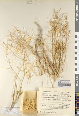
LE 01174184
Carex vulpina L. det. Konechnaya, Galina Yurievna, Haare, Ado Oskarovich at 03.06.1992
Collectors: Konechnaya, Galina Yurievna; Haare, Ado Oskarovich Collection date: 03.06.1992. Administrative regions: RU - Leningradskaya Oblast' - Tosnenskiy Rayon. Groups of specimens: Образцы сектора Восточной Европы; Соглашение Минобрнауки №075-15-2021-1056Original label text:Ленинградская область, Тосненский район, железнодорожная станция Трубниково, рядом с железнодорожным переездом, луг у железной дороги.
Coordinates (geographic position): 59° 16′ 9.84″ N, 31° 24′ 17.97″ E ±500 mRecord creation: 2023-07-26, Artyom Borodushkin, PhotoScan D2.Citation: Specimen LE 01174184 // Virtual herbarium of Komarov Botanical Institute RAS — http://re.herbariumle.ru/01174184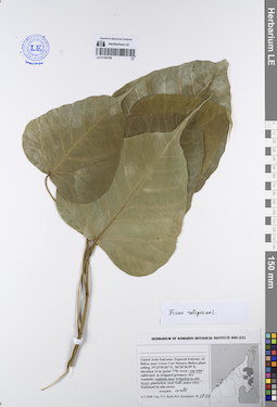
LE 01194758
Ficus religiosa L. det. Byalt, Vyacheslav Vyacheslavovich
Administrative regions: AE - United Arab Emirates. Groups of specimens: Образцы общего сектора; Соглашение Минобрнауки №075-15-2021-1056; Бялт В.В.: Флора ФуджейрыRecord creation: 2023-07-31, Larisa Orlova, PhotoScan D2.Citation: Specimen LE 01194758 // Virtual herbarium of Komarov Botanical Institute RAS — http://re.herbariumle.ru/01194758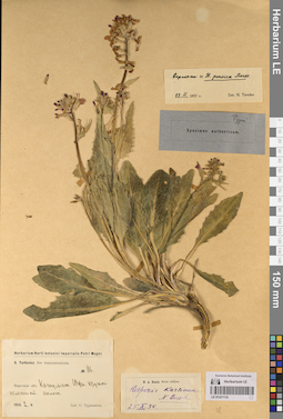
LE 01221133
Groups of specimens: Образцы сектора Кавказа; Типовые образцы сектора Кавказа; Соглашение Минобрнауки №075-15-2021-1056Record creation: 2023-07-31, Elena Portenier, PhotoScan D2.Citation: Specimen LE 01221133 // Virtual herbarium of Komarov Botanical Institute RAS — http://re.herbariumle.ru/01221133
LE 01221189
Groups of specimens: Образцы сектора Кавказа; Типовые образцы сектора Кавказа; Соглашение Минобрнауки №075-15-2021-1056Record creation: 2023-08-01, Elena Portenier, PhotoScan D2.Citation: Specimen LE 01221189 // Virtual herbarium of Komarov Botanical Institute RAS — http://re.herbariumle.ru/01221189
LE 01207278
Erucastrum takhtajanii V.I. Dorof. det. Dorofeyev, Vladimir Ivanovich
Additional identifications: Erucastrum armoracioides (Czern. ex Turcz.) Cruchet Collectors: Danchenco, A. Collection date: 28.06.1996. Administrative regions: AM - Armenia. Place of collection: Khoseov reserue, верхний кордон.Groups of specimens: Образцы сектора Кавказа; Типовые образцы сектора Кавказа; Соглашение Минобрнауки №075-15-2021-1056Original label text:Erucastrum takhtajanii V.I. Dorof
Paratyous!
Khoseov reserue, верхний кордон, 2000 м, 28.6.96
осыпь сухая
Dannchtnco A. leg.
Армения
опуш. ф. Erucastrum armocarioides.
Habitat / plant community in location of collecting: осыпь сухаяCoordinates (geographic position): 2000 m a.s.l.Record creation: 2023-07-28, Elena Portenier, PhotoScan D2.Citation: Specimen LE 01207278 // Virtual herbarium of Komarov Botanical Institute RAS — http://re.herbariumle.ru/01207278Paratyous!
Khoseov reserue, верхний кордон, 2000 м, 28.6.96
осыпь сухая
Dannchtnco A. leg.
Армения
опуш. ф. Erucastrum armocarioides.
LE 01106194
Carex caryophyllea Latourr. det. Pusyrev, Alexander Nikolaevich at 03.05.2001
Collectors: Pusyrev, Alexander Nikolaevich Collection date: 03.05.2001. Administrative regions: RU - Udmurtskaya Respublika - Izhevsk. Groups of specimens: Образцы сектора Восточной Европы; Соглашение Минобрнауки №075-15-2021-1056; Гербарий Удмуртского Госуниверситета.; Флора Урала и прилегающих территорий (проект)Original label text:Удмуртская республика, город Ижевск, Октябрьский район, между улицей Холмогорова и микрорайоном "Север". Лесная поляна наверху склона правого коренного берега реки Подборенка близ верхнего пруда.
LE 01220156
Groups of specimens: Образцы сектора Кавказа; Типовые образцы сектора Кавказа; Соглашение Минобрнауки №075-15-2021-1056Record creation: 2023-07-26, Elena Portenier, PhotoScan D2.Citation: Specimen LE 01220156 // Virtual herbarium of Komarov Botanical Institute RAS — http://re.herbariumle.ru/01220156
LE 01174183
Carex caespitosa L. det. Konechnaya, Galina Yurievna, Haare, Ado Oskarovich at 01.05.1990
Collectors: Konechnaya, Galina Yurievna; Haare, Ado Oskarovich Collection date: 01.05.1990. Administrative regions: RU - Leningradskaya Oblast' - Tosnenskiy Rayon. Groups of specimens: Образцы сектора Восточной Европы; Соглашение Минобрнауки №075-15-2021-1056Original label text:Ленинградская область, Тосненский район, железнодорожная станция Померанье, луг с восточной стороны дороги.
Coordinates (geographic position): 59° 18′ 41.7″ N, 31° 19′ 31.07″ E ±500 mRecord creation: 2023-07-26, Artyom Borodushkin, PhotoScan D2.Citation: Specimen LE 01174183 // Virtual herbarium of Komarov Botanical Institute RAS — http://re.herbariumle.ru/01174183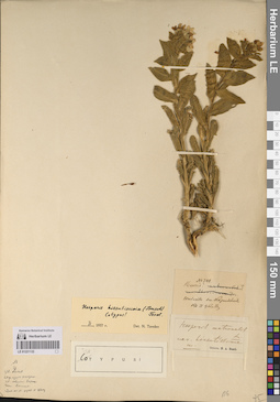
LE 01221132
Groups of specimens: Образцы сектора Кавказа; Типовые образцы сектора Кавказа; Соглашение Минобрнауки №075-15-2021-1056Record creation: 2023-07-31, Elena Portenier, PhotoScan D2.Citation: Specimen LE 01221132 // Virtual herbarium of Komarov Botanical Institute RAS — http://re.herbariumle.ru/01221132
LE 01194757
Ficus benghalensis L. det. Byalt, Vyacheslav Vyacheslavovich
Administrative regions: AE - United Arab Emirates. Groups of specimens: Образцы общего сектора; Соглашение Минобрнауки №075-15-2021-1056; Бялт В.В.: Флора ФуджейрыRecord creation: 2023-07-31, Larisa Orlova, PhotoScan D2.Citation: Specimen LE 01194757 // Virtual herbarium of Komarov Botanical Institute RAS — http://re.herbariumle.ru/01194757
LE 01221188
Groups of specimens: Образцы сектора Кавказа; Типовые образцы сектора Кавказа; Соглашение Минобрнауки №075-15-2021-1056Record creation: 2023-08-01, Elena Portenier, PhotoScan D2.Citation: Specimen LE 01221188 // Virtual herbarium of Komarov Botanical Institute RAS — http://re.herbariumle.ru/01221188
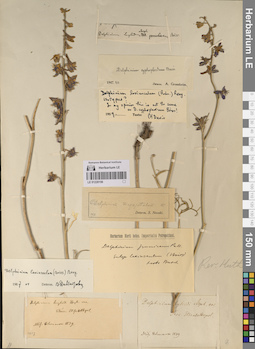
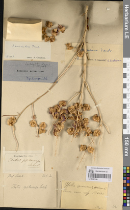
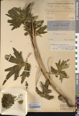
LE 01207277
Erucastrum takhtajanii V.I. Dorof. det. Dorofeyev, Vladimir Ivanovich at 01.05.2000
Collectors: Takhtajan, Armen Leonovich; Popova, Tamara Nikitichna Collection date: 25.08.1966. Administrative regions: AM - Armenia. Subregion: Арташатский р-н. Place of collection: Окр. п. Юва.Groups of specimens: Образцы сектора Кавказа; Типовые образцы сектора Кавказа; Соглашение Минобрнауки №075-15-2021-1056; Гербарий Ботанического Института Академии наук СССРOriginal label text:Гербарий Ботанического Института Академии наук СССР
Erucastrum takhtajanii V.I. Dorof. sp. nov.
Арм. ССР. Арташатский р-н Окр. п. Юва, сухие склоны у травертин.
25.8.1966
Собр. А. Л. Тахтаджян, Т. Н. Попова
01.05.2000 Опр. V.I. Dorofeev.
2000 Бот. журн. 85, 7: 183
Isotypus!
Det. V. Dorofeev 2000
Habitat / plant community in location of collecting: сухие склоны у травертинRecord creation: 2023-07-28, Elena Portenier, PhotoScan D2.Citation: Specimen LE 01207277 // Virtual herbarium of Komarov Botanical Institute RAS — http://re.herbariumle.ru/01207277Erucastrum takhtajanii V.I. Dorof. sp. nov.
Арм. ССР. Арташатский р-н Окр. п. Юва, сухие склоны у травертин.
25.8.1966
Собр. А. Л. Тахтаджян, Т. Н. Попова
01.05.2000 Опр. V.I. Dorofeev.
2000 Бот. журн. 85, 7: 183
Isotypus!
Det. V. Dorofeev 2000
LE 01106193
Carex capillaris L. det. Pusyrev, Alexander Nikolaevich at 16.06.2001
Collectors: Pusyrev, Alexander Nikolaevich; Baranova, Olga Germanovna Collection date: 16.06.2001. Administrative regions: RUUdmurtskaya Respublika - Alnashskiy Rayon. Groups of specimens: Образцы сектора Восточной Европы; Соглашение Минобрнауки №075-15-2021-1056; Гербарий Удмуртского Госуниверситета.; Флора Урала и прилегающих территорий (проект)Original label text:Удмуртская республика, Алнашский район, 1,5 км восточнее-северо-восточнее деревни Байтеряково, 2 км западнее села Нижнее Асаново. Сырой луг на правом берегу реки Тойма.
Coordinates (geographic position): 56° 5′ 18.07″ N, 52° 28′ 0.44″ E ±1000 mRecord creation: 2023-07-27, Artyom Borodushkin, PhotoScan D2.Citation: Specimen LE 01106193 // Virtual herbarium of Komarov Botanical Institute RAS — http://re.herbariumle.ru/01106193
LE 01220155
Groups of specimens: Образцы сектора Кавказа; Типовые образцы сектора Кавказа; Соглашение Минобрнауки №075-15-2021-1056Record creation: 2023-07-26, Elena Portenier, PhotoScan D2.Citation: Specimen LE 01220155 // Virtual herbarium of Komarov Botanical Institute RAS — http://re.herbariumle.ru/01220155
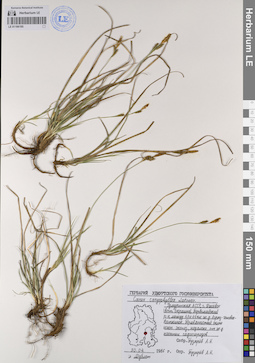
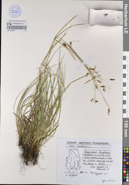
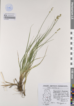
LE 01173837
Carex ornithopoda Willd. det. Myalik A. M. (объединить с Мялик А. Н.) at 02.06.2019
Collectors: Myalik A. M. (объединить с Мялик А. Н.) Field collecting number: 231/19. Collection date: 02.06.2019. Administrative regions: LV - Madona Municipality - Sarkanu pagasts. Groups of specimens: Образцы сектора Восточной Европы; Соглашение Минобрнауки №075-15-2021-1056; HERBARIUM ALIAKSANDR MIALIKOriginal label text:МЕСТО СБОРА: Латвия, Мадонский край, Сарканская волость, деревня Паткуле, 2,5 км к северо-западу, 56°55'05.4''N 26°15'14.6''E.
УСЛОВИЯ ОБИТАНИЯ: сухая луговина на морене, у опушки смешанного леса, изредка.
Latvia, municipalites Madona, village Patkule (meadow on the moraine hill).
LE 01221131
Groups of specimens: Образцы сектора Кавказа; Типовые образцы сектора Кавказа; Соглашение Минобрнауки №075-15-2021-1056Record creation: 2023-07-31, Elena Portenier, PhotoScan D2.Citation: Specimen LE 01221131 // Virtual herbarium of Komarov Botanical Institute RAS — http://re.herbariumle.ru/01221131
LE 01221187
Groups of specimens: Образцы сектора Кавказа; Типовые образцы сектора Кавказа; Соглашение Минобрнауки №075-15-2021-1056Record creation: 2023-08-01, Elena Portenier, PhotoScan D2.Citation: Specimen LE 01221187 // Virtual herbarium of Komarov Botanical Institute RAS — http://re.herbariumle.ru/01221187
LE 01106192
Carex capillaris L. det. Pusyrev, Alexander Nikolaevich at 26.07.2003
Collectors: Pusyrev, Alexander Nikolaevich Collection date: 26.07.2003. Administrative regions: RU - Udmurtskaya Respublika - Izhevsk. Groups of specimens: Образцы сектора Восточной Европы; Соглашение Минобрнауки №075-15-2021-1056; Гербарий Удмуртского Госуниверситета.; Флора Урала и прилегающих территорий (проект)Original label text:Удмуртская республика, город Ижевск, Октябрьский район, 2 км юго-западнее деревни Пазелы, 4 км севернее Воткинского шоссе, правый берег реки Пазелинка. Заболоченный лес с елью, березой, сосной; мало.
Coordinates (geographic position): 56° 54′ 47.84″ N, 53° 15′ 23.72″ E ±1500 mRecord creation: 2023-07-27, Artyom Borodushkin, PhotoScan D2.Citation: Specimen LE 01106192 // Virtual herbarium of Komarov Botanical Institute RAS — http://re.herbariumle.ru/01106192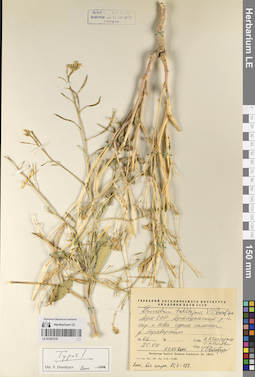
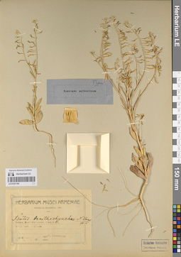
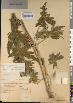
LE 01207276
Erucastrum takhtajanii V.I. Dorof. det. Dorofeyev, Vladimir Ivanovich at 01.05.2000
Collectors: Takhtajan, Armen Leonovich; Popova, Tamara Nikitichna Administrative regions: AM - Armenia. Subregion: Арташатский р-н. Place of collection: Окр. п. Юва.Groups of specimens: Образцы сектора Кавказа; Типовые образцы сектора Кавказа; Соглашение Минобрнауки №075-15-2021-1056; Гербарий Ботанического Института Академии наук СССРOriginal label text:Гербарий Ботанического Института Академии наук СССР
Erucastrum takhtajanii V.I. Dorof. sp. nov.
Арм. ССР. Арташатский р-н Окр. п. Юва, сухие склоны у травертин.
25.8.1966
Собр. А. Л. Тахтаджян, Т. Н. Попова
01.05.2000 Опр. V.I. Dorofeev.
Typus!
Det. V. Dorofeev 2000
Habitat / plant community in location of collecting: сухие склоны у травертинRecord creation: 2023-07-28, Elena Portenier, PhotoScan D2.Citation: Specimen LE 01207276 // Virtual herbarium of Komarov Botanical Institute RAS — http://re.herbariumle.ru/01207276Erucastrum takhtajanii V.I. Dorof. sp. nov.
Арм. ССР. Арташатский р-н Окр. п. Юва, сухие склоны у травертин.
25.8.1966
Собр. А. Л. Тахтаджян, Т. Н. Попова
01.05.2000 Опр. V.I. Dorofeev.
Typus!
Det. V. Dorofeev 2000
LE 01194756
Ficus benghalensis L. det. Byalt, Vyacheslav Vyacheslavovich
Administrative regions: AE - United Arab Emirates. Groups of specimens: Образцы общего сектора; Соглашение Минобрнауки №075-15-2021-1056; Бялт В.В.: Флора ФуджейрыRecord creation: 2023-07-31, Larisa Orlova, PhotoScan D2.Citation: Specimen LE 01194756 // Virtual herbarium of Komarov Botanical Institute RAS — http://re.herbariumle.ru/01194756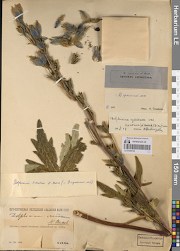
LE 01220154
Groups of specimens: Образцы сектора Кавказа; Типовые образцы сектора Кавказа; Соглашение Минобрнауки №075-15-2021-1056Record creation: 2023-07-26, Elena Portenier, PhotoScan D2.Citation: Specimen LE 01220154 // Virtual herbarium of Komarov Botanical Institute RAS — http://re.herbariumle.ru/01220154
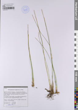
LE 01173773
Trichophorum alpinum (L.) Pers. det. Myalik A. M. (объединить с Мялик А. Н.) at 11.07.2020
Collectors: Myalik A. M. (объединить с Мялик А. Н.) Field collecting number: 1322/20. Collection date: 11.07.2020. Administrative regions: BY - Grodno Oblast. Groups of specimens: Образцы сектора Восточной Европы; Соглашение Минобрнауки №075-15-2021-1056; HERBARIUM MSKHOriginal label text:МЕСТО СБОРА: Беларусь, Гродненская область, Ивьевский район, деревня Лукашино, 1,4 км к югу, заказник Урочище Красное, 53°54'32.6''N 25°42'14.6''E
УСЛОВИЯ ОБИТАНИЯ: низкотравный влажный луг на зарастающей торфоразработке, часто.
Belarus, Hrodna region, Ivie District, village Lukasyna (wet meadow, old peat mining)ю
LE 01221186
Groups of specimens: Образцы сектора Кавказа; Типовые образцы сектора Кавказа; Соглашение Минобрнауки №075-15-2021-1056Record creation: 2023-08-01, Elena Portenier, PhotoScan D2.Citation: Specimen LE 01221186 // Virtual herbarium of Komarov Botanical Institute RAS — http://re.herbariumle.ru/01221186
LE 01221130
Groups of specimens: Образцы сектора Кавказа; Типовые образцы сектора Кавказа; Соглашение Минобрнауки №075-15-2021-1056Record creation: 2023-07-31, Elena Portenier, PhotoScan D2.Citation: Specimen LE 01221130 // Virtual herbarium of Komarov Botanical Institute RAS — http://re.herbariumle.ru/01221130
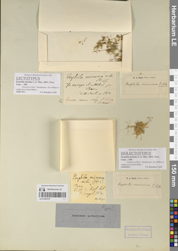
LE 01207275
Erophila minima C.A. Mey. det. Dorofeyev, Vladimir Ivanovich at 16.06.2011
Collection date: 1830. Groups of specimens: Образцы сектора Кавказа; Типовые образцы сектора Кавказа; Соглашение Минобрнауки №075-15-2021-1056Original label text:Komarov Botanical Institute RAS
LECTOTYPUS
Erophila minima C.A. Mey. 1831, Verz. Cauc.: 184.
Описан из Вост. Закавказья: «In collibus et campis provinciae Baku».
16.06.2011
V.I. Dorofeyev (LE)
N. A. Busch. Notae criticae.
Erophila minima C.A.M.
Erophila minims mihi
№ 47 (1624)
Baku.
Cult. in hort. bot. petropol. 1834 [Meyer]
Komarov Botanical Institute RAS
ISOLECTOTYPUS
Erophila minima C.A. Mey. 1831, Verz. Cauc.: 184.
Описан из Вост. Закавказья: «In collibus et campis provinciae Baku».
16.06.2011
V.I. Dorofeyev (LE)
Record creation: 2023-07-28, Elena Portenier, PhotoScan D2.Citation: Specimen LE 01207275 // Virtual herbarium of Komarov Botanical Institute RAS — http://re.herbariumle.ru/01207275LECTOTYPUS
Erophila minima C.A. Mey. 1831, Verz. Cauc.: 184.
Описан из Вост. Закавказья: «In collibus et campis provinciae Baku».
16.06.2011
V.I. Dorofeyev (LE)
N. A. Busch. Notae criticae.
Erophila minima C.A.M.
Erophila minims mihi
№ 47 (1624)
Baku.
Cult. in hort. bot. petropol. 1834 [Meyer]
Komarov Botanical Institute RAS
ISOLECTOTYPUS
Erophila minima C.A. Mey. 1831, Verz. Cauc.: 184.
Описан из Вост. Закавказья: «In collibus et campis provinciae Baku».
16.06.2011
V.I. Dorofeyev (LE)
LE 01106191
Carex canescens L. det. Pusyrev, Alexander Nikolaevich at 19.06.1990
Collectors: Pusyrev, Alexander Nikolaevich; Baranova, Olga Germanovna Collection date: 19.06.1990. Administrative regions: RUUdmurtskaya Respublika - Kambarskiy Rayon. Groups of specimens: Образцы сектора Восточной Европы; Соглашение Минобрнауки №075-15-2021-1056; Гербарий Удмуртского Госуниверситета.; Флора Урала и прилегающих территорий (проект)Original label text:Удмуртская АССР, Камбарский район, 0,5 км восточнее города Камбарка. Небольшое сырое понижение в сосновом бору.
Coordinates (geographic position): 56° 17′ 45.61″ N, 54° 11′ 25.56″ E ±500 mRecord creation: 2023-07-27, Artyom Borodushkin, PhotoScan D2.Citation: Specimen LE 01106191 // Virtual herbarium of Komarov Botanical Institute RAS — http://re.herbariumle.ru/01106191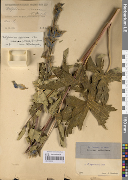
LE 01220153
Groups of specimens: Образцы сектора Кавказа; Типовые образцы сектора Кавказа; Соглашение Минобрнауки №075-15-2021-1056Record creation: 2023-07-26, Elena Portenier, PhotoScan D2.Citation: Specimen LE 01220153 // Virtual herbarium of Komarov Botanical Institute RAS — http://re.herbariumle.ru/01220153
LE 01194755
Ficus religiosa L. det. Byalt, Vyacheslav Vyacheslavovich
Administrative regions: AE - United Arab Emirates. Groups of specimens: Образцы общего сектора; Соглашение Минобрнауки №075-15-2021-1056; Бялт В.В.: Флора ФуджейрыRecord creation: 2023-07-31, Larisa Orlova, PhotoScan D2.Citation: Specimen LE 01194755 // Virtual herbarium of Komarov Botanical Institute RAS — http://re.herbariumle.ru/01194755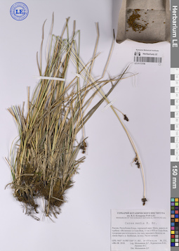
LE 01173756
Carex media R. Br. det. Melnikov, Denis Germanovich at 08.08.2018
Collectors: Melnikov, Denis Germanovich; Kuropatkin, Vladislav Valerievich; Lalenko Il'ya Sergeevich Field collecting number: 222. Collection date: 08.08.2018. Administrative regions: RU - Komi - Inta (gorodskoj okrug). Groups of specimens: Образцы сектора Восточной Европы; Соглашение Минобрнауки №075-15-2021-1056; Флора Урала и прилегающих территорий (проект)Original label text:Россия, Республика Коми, городской округ Инта, дорога от турбазы "Желанное" в Сана-Вож, 11 км к юго-западу от Сана-Вож, тундровая растительность (по типу верхового болота) на левом берегу реки Балбанъю, во мху. Растет кочкой.
Coordinates (geographic position): 65° 17′ 32.58″ N, 60° 33′ 13.98″ E ±500 mRecord creation: 2023-07-26, Artyom Borodushkin, PhotoScan D2.Citation: Specimen LE 01173756 // Virtual herbarium of Komarov Botanical Institute RAS — http://re.herbariumle.ru/01173756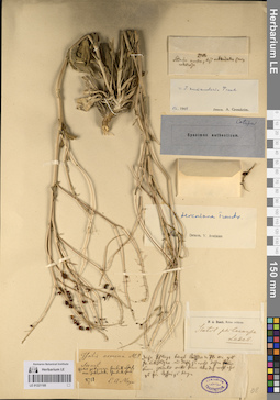
LE 01221185
Groups of specimens: Образцы сектора Кавказа; Типовые образцы сектора Кавказа; Соглашение Минобрнауки №075-15-2021-1056Record creation: 2023-08-01, Elena Portenier, PhotoScan D2.Citation: Specimen LE 01221185 // Virtual herbarium of Komarov Botanical Institute RAS — http://re.herbariumle.ru/01221185
LE 01106190
Carex canescens L. det. Pusyrev, Alexander Nikolaevich at 27.06.1999
Collectors: Pusyrev, Alexander Nikolaevich; Veselkova Nelli Rafailovna Collection date: 27.06.1999. Administrative regions: RU - Udmurtskaya Respublika - Zav'yalovskiy Rayon. Groups of specimens: Образцы сектора Восточной Европы; Соглашение Минобрнауки №075-15-2021-1056; Гербарий Удмуртского Госуниверситета.; Флора Урала и прилегающих территорий (проект)Original label text:Удмуртская АССР, Завьяловский район, 0,5 км севернее села Люк, левый берег реки Шурвайка (левый приток реки Люк). Заболоченный участок леса (лесная опушка), обильно.
Coordinates (geographic position): 56° 55′ 32.59″ N, 52° 49′ 6.06″ E ±200 mRecord creation: 2023-07-27, Artyom Borodushkin, PhotoScan D2.Citation: Specimen LE 01106190 // Virtual herbarium of Komarov Botanical Institute RAS — http://re.herbariumle.ru/01106190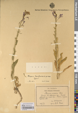
LE 01221129
Groups of specimens: Образцы сектора Кавказа; Типовые образцы сектора Кавказа; Соглашение Минобрнауки №075-15-2021-1056Record creation: 2023-07-31, Elena Portenier, PhotoScan D2.Citation: Specimen LE 01221129 // Virtual herbarium of Komarov Botanical Institute RAS — http://re.herbariumle.ru/01221129
LE 01072956
Groups of specimens: Образцы сектора Кавказа; Типовые образцы сектора Кавказа; Соглашение Минобрнауки №075-15-2021-1056Record creation: 2023-07-28, Elena Portenier, PhotoScan D2.Citation: Specimen LE 01072956 // Virtual herbarium of Komarov Botanical Institute RAS — http://re.herbariumle.ru/01072956
LE 01220152
Groups of specimens: Образцы сектора Кавказа; Типовые образцы сектора Кавказа; Соглашение Минобрнауки №075-15-2021-1056Record creation: 2023-07-26, Elena Portenier, PhotoScan D2.Citation: Specimen LE 01220152 // Virtual herbarium of Komarov Botanical Institute RAS — http://re.herbariumle.ru/01220152
LE 01173725
Carex rostrata Stokes det. Myalik A. M. (объединить с Мялик А. Н.), Kurchonok A. V. at 09.06.2020
Collectors: Myalik A. M. (объединить с Мялик А. Н.); Kurchonok A. V. Field collecting number: 547/20. Collection date: 09.06.2020. Administrative regions: BY - Vitebsk Oblast - Myorski Rayon. Groups of specimens: Образцы сектора Восточной Европы; Соглашение Минобрнауки №075-15-2021-1056; HERBARIUM MSKHOriginal label text:МЕСТО СБОРА: Беларусь, Витебская область, Миорский район, деревня Сухие, 2,5 км к востоку, заказник Ельня, 55°32'39.1''N 27°43'17.4''E
УСЛОВИЯ ОБИТАНИЯ: влажная мочажина, на краю верхового болота, часто.
Belarus, Vicebsk Region, Mijory District, village Suchija, reserve Elnia (raised bog).
LE 01221184
Groups of specimens: Образцы сектора Кавказа; Типовые образцы сектора Кавказа; Соглашение Минобрнауки №075-15-2021-1056Record creation: 2023-08-01, Elena Portenier, PhotoScan D2.Citation: Specimen LE 01221184 // Virtual herbarium of Komarov Botanical Institute RAS — http://re.herbariumle.ru/01221184
LE 01106189
Carex canescens L. det. Pusyrev, Alexander Nikolaevich at 30.05.1989
Collectors: Pusyrev, Alexander Nikolaevich; Baranova, Olga Germanovna Collection date: 30.05.1989. Administrative regions: RUUdmurtskaya Respublika - Yakshur-Bod'inskiy Rayon. Groups of specimens: Образцы сектора Восточной Европы; Соглашение Минобрнауки №075-15-2021-1056; Гербарий Удмуртского Госуниверситета.; Флора Урала и прилегающих территорий (проект)Original label text:Удмуртская АССР, Якшур-Бодьинский район, 0,5 км восточнее поселка Канифольный. Небольшое торфяное болото в сосновом бору, близ лесной дороги.
Coordinates (geographic position): 57° 5′ 8.04″ N, 53° 12′ 45.6″ E ±200 mRecord creation: 2023-07-27, Artyom Borodushkin, PhotoScan D2.Citation: Specimen LE 01106189 // Virtual herbarium of Komarov Botanical Institute RAS — http://re.herbariumle.ru/01106189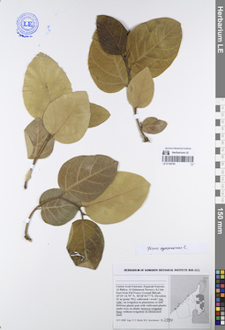
LE 01194754
Ficus sycomorus L. det. Byalt, Vyacheslav Vyacheslavovich
Administrative regions: AE - United Arab Emirates. Groups of specimens: Образцы общего сектора; Соглашение Минобрнауки №075-15-2021-1056; Бялт В.В.: Флора ФуджейрыRecord creation: 2023-07-31, Larisa Orlova, PhotoScan D2.Citation: Specimen LE 01194754 // Virtual herbarium of Komarov Botanical Institute RAS — http://re.herbariumle.ru/01194754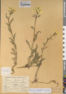
LE 01072955
Groups of specimens: Образцы сектора Кавказа; Типовые образцы сектора Кавказа; Соглашение Минобрнауки №075-15-2021-1056Record creation: 2023-07-28, Elena Portenier, PhotoScan D2.Citation: Specimen LE 01072955 // Virtual herbarium of Komarov Botanical Institute RAS — http://re.herbariumle.ru/01072955
LE 01220151
Groups of specimens: Образцы сектора Кавказа; Типовые образцы сектора Кавказа; Соглашение Минобрнауки №075-15-2021-1056Record creation: 2023-07-26, Elena Portenier, PhotoScan D2.Citation: Specimen LE 01220151 // Virtual herbarium of Komarov Botanical Institute RAS — http://re.herbariumle.ru/01220151
LE 01173683
Carex muricata L.
Collectors: Vasilevich, Vladislav Ivanovich; Sambuk, S. G. Field collecting number: 94. Collection date: 17.06.1986. Administrative regions: RU - Nizhegorodskaya Oblast' - Shatkovskiy Rayon. Groups of specimens: Образцы сектора Восточной Европы; Соглашение Минобрнауки №075-15-2021-1056Original label text:Горьковская область, Шатковский район, западнее Шатков 5 км, оп 121 Дубняк снытевый.
Coordinates (geographic position): 55° 11′ 16.95″ N, 44° 7′ 40.75″ E ±1000 mRecord creation: 2023-07-26, Artyom Borodushkin, PhotoScan D2.Citation: Specimen LE 01173683 // Virtual herbarium of Komarov Botanical Institute RAS — http://re.herbariumle.ru/01173683