View
Add
Copy
Edit
Delete
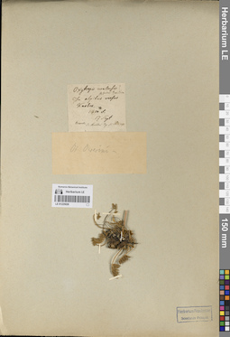
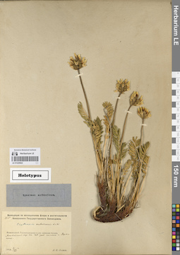
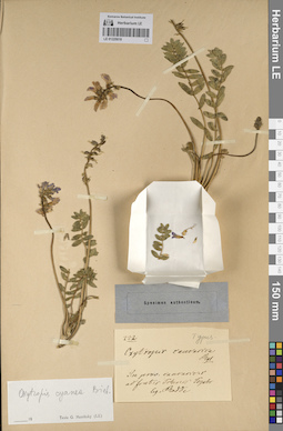
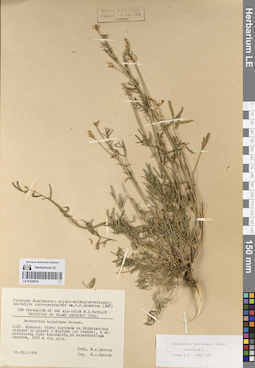
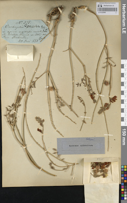
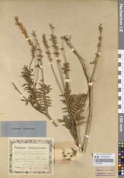
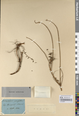
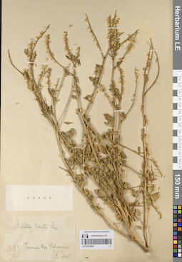
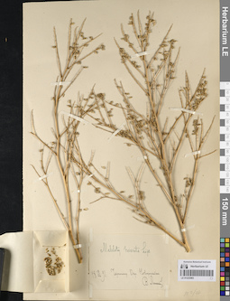
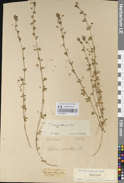
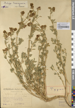
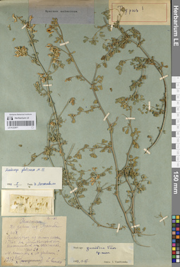
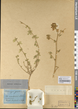
LE 01225026
Groups of specimens: Образцы сектора Кавказа; Типовые образцы сектора Кавказа; Соглашение Минобрнауки №075-15-2021-1056Record creation: 2023-08-26, Elena Portenier, PhotoScan D2.Citation: Specimen LE 01225026 // Virtual herbarium of Komarov Botanical Institute RAS — http://re.herbariumle.ru/01225026
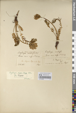
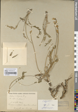
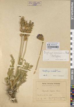
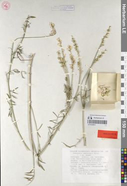
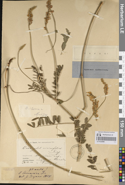
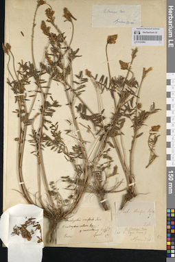
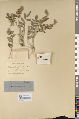
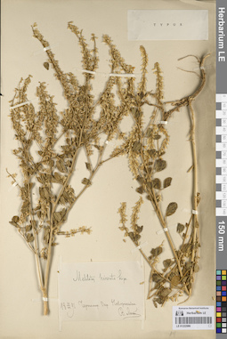
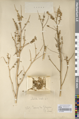
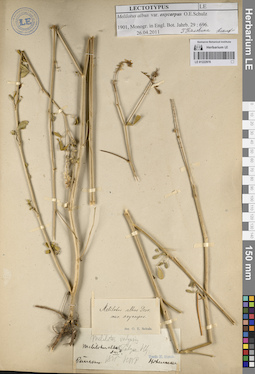
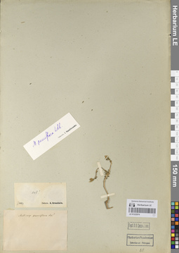
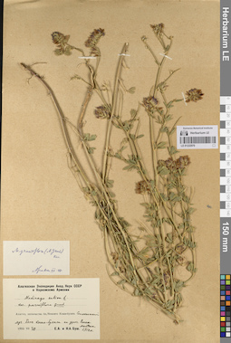
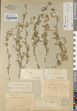
LE 01225025
Groups of specimens: Образцы сектора Кавказа; Типовые образцы сектора Кавказа; Соглашение Минобрнауки №075-15-2021-1056Record creation: 2023-08-26, Elena Portenier, PhotoScan D2.Citation: Specimen LE 01225025 // Virtual herbarium of Komarov Botanical Institute RAS — http://re.herbariumle.ru/01225025
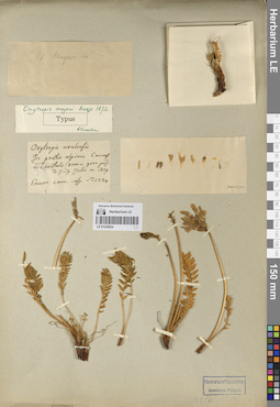
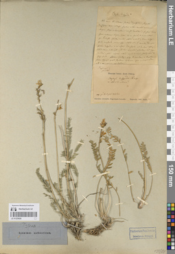
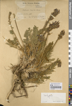
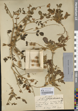
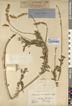
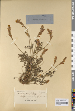
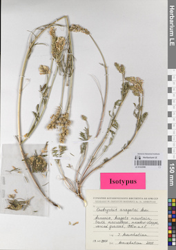
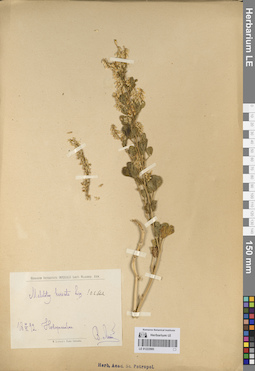
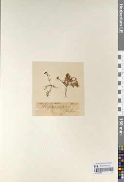
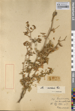
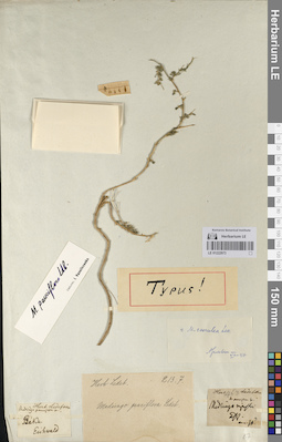
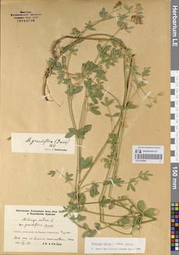
LE 01225024
Groups of specimens: Образцы сектора Кавказа; Типовые образцы сектора Кавказа; Соглашение Минобрнауки №075-15-2021-1056Record creation: 2023-08-26, Elena Portenier, PhotoScan D2.Citation: Specimen LE 01225024 // Virtual herbarium of Komarov Botanical Institute RAS — http://re.herbariumle.ru/01225024
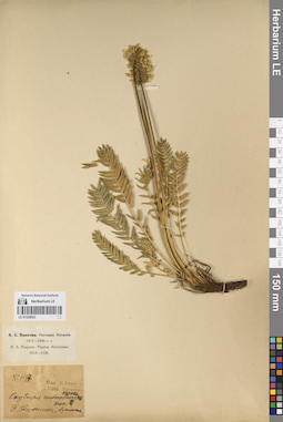
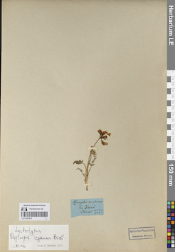
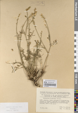
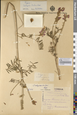
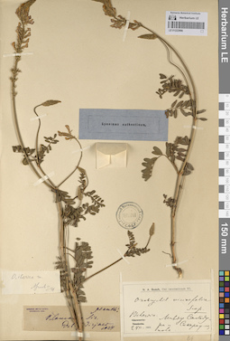
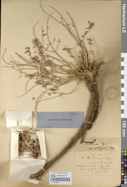
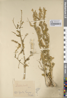
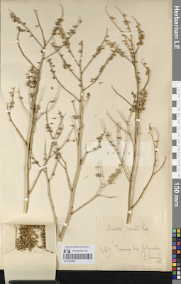
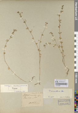
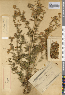
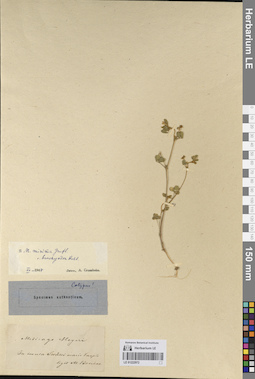
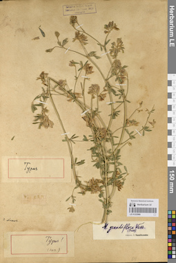
LE 01225023
Groups of specimens: Образцы сектора Кавказа; Типовые образцы сектора Кавказа; Соглашение Минобрнауки №075-15-2021-1056Record creation: 2023-08-26, Elena Portenier, PhotoScan D2.Citation: Specimen LE 01225023 // Virtual herbarium of Komarov Botanical Institute RAS — http://re.herbariumle.ru/01225023
LE 01225022
Groups of specimens: Образцы сектора Кавказа; Типовые образцы сектора Кавказа; Соглашение Минобрнауки №075-15-2021-1056Record creation: 2023-08-26, Elena Portenier, PhotoScan D2.Citation: Specimen LE 01225022 // Virtual herbarium of Komarov Botanical Institute RAS — http://re.herbariumle.ru/01225022
LE 01225021
Groups of specimens: Образцы сектора Кавказа; Типовые образцы сектора Кавказа; Соглашение Минобрнауки №075-15-2021-1056Record creation: 2023-08-26, Elena Portenier, PhotoScan D2.Citation: Specimen LE 01225021 // Virtual herbarium of Komarov Botanical Institute RAS — http://re.herbariumle.ru/01225021
LE 01225020
Groups of specimens: Образцы сектора Кавказа; Типовые образцы сектора Кавказа; Соглашение Минобрнауки №075-15-2021-1056Record creation: 2023-08-26, Elena Portenier, PhotoScan D2.Citation: Specimen LE 01225020 // Virtual herbarium of Komarov Botanical Institute RAS — http://re.herbariumle.ru/01225020
LE 01225019
Groups of specimens: Образцы сектора Кавказа; Типовые образцы сектора Кавказа; Соглашение Минобрнауки №075-15-2021-1056Record creation: 2023-08-26, Elena Portenier, PhotoScan D2.Citation: Specimen LE 01225019 // Virtual herbarium of Komarov Botanical Institute RAS — http://re.herbariumle.ru/01225019
LE 01225018
Groups of specimens: Образцы сектора Кавказа; Типовые образцы сектора Кавказа; Соглашение Минобрнауки №075-15-2021-1056Record creation: 2023-08-26, Elena Portenier, PhotoScan D2.Citation: Specimen LE 01225018 // Virtual herbarium of Komarov Botanical Institute RAS — http://re.herbariumle.ru/01225018
LE 01225017
Groups of specimens: Образцы сектора Кавказа; Типовые образцы сектора Кавказа; Соглашение Минобрнауки №075-15-2021-1056Record creation: 2023-08-26, Elena Portenier, PhotoScan D2.Citation: Specimen LE 01225017 // Virtual herbarium of Komarov Botanical Institute RAS — http://re.herbariumle.ru/01225017
LE 01225016
Groups of specimens: Образцы сектора Кавказа; Типовые образцы сектора Кавказа; Соглашение Минобрнауки №075-15-2021-1056Record creation: 2023-08-26, Elena Portenier, PhotoScan D2.Citation: Specimen LE 01225016 // Virtual herbarium of Komarov Botanical Institute RAS — http://re.herbariumle.ru/01225016
LE 01225015
Groups of specimens: Образцы сектора Кавказа; Типовые образцы сектора Кавказа; Соглашение Минобрнауки №075-15-2021-1056Record creation: 2023-08-26, Elena Portenier, PhotoScan D2.Citation: Specimen LE 01225015 // Virtual herbarium of Komarov Botanical Institute RAS — http://re.herbariumle.ru/01225015
LE 01225014
Groups of specimens: Образцы сектора Кавказа; Типовые образцы сектора Кавказа; Соглашение Минобрнауки №075-15-2021-1056Record creation: 2023-08-26, Elena Portenier, PhotoScan D2.Citation: Specimen LE 01225014 // Virtual herbarium of Komarov Botanical Institute RAS — http://re.herbariumle.ru/01225014
LE 01225013
Groups of specimens: Образцы сектора Кавказа; Типовые образцы сектора Кавказа; Соглашение Минобрнауки №075-15-2021-1056Record creation: 2023-08-26, Elena Portenier, PhotoScan D2.Citation: Specimen LE 01225013 // Virtual herbarium of Komarov Botanical Institute RAS — http://re.herbariumle.ru/01225013
LE 01225012
Groups of specimens: Образцы сектора Кавказа; Типовые образцы сектора Кавказа; Соглашение Минобрнауки №075-15-2021-1056Record creation: 2023-08-26, Elena Portenier, PhotoScan D2.Citation: Specimen LE 01225012 // Virtual herbarium of Komarov Botanical Institute RAS — http://re.herbariumle.ru/01225012
LE 01223000
Groups of specimens: Образцы сектора Кавказа; Типовые образцы сектора Кавказа; Соглашение Минобрнауки №075-15-2021-1056Record creation: 2023-08-26, Elena Portenier, PhotoScan D2.Citation: Specimen LE 01223000 // Virtual herbarium of Komarov Botanical Institute RAS — http://re.herbariumle.ru/01223000
LE 01222999
Groups of specimens: Образцы сектора Кавказа; Типовые образцы сектора Кавказа; Соглашение Минобрнауки №075-15-2021-1056Record creation: 2023-08-26, Elena Portenier, PhotoScan D2.Citation: Specimen LE 01222999 // Virtual herbarium of Komarov Botanical Institute RAS — http://re.herbariumle.ru/01222999
LE 01222998
Groups of specimens: Образцы сектора Кавказа; Типовые образцы сектора Кавказа; Соглашение Минобрнауки №075-15-2021-1056Record creation: 2023-08-26, Elena Portenier, PhotoScan D2.Citation: Specimen LE 01222998 // Virtual herbarium of Komarov Botanical Institute RAS — http://re.herbariumle.ru/01222998
LE 01222997
Groups of specimens: Образцы сектора Кавказа; Типовые образцы сектора Кавказа; Соглашение Минобрнауки №075-15-2021-1056Record creation: 2023-08-26, Elena Portenier, PhotoScan D2.Citation: Specimen LE 01222997 // Virtual herbarium of Komarov Botanical Institute RAS — http://re.herbariumle.ru/01222997
LE 01222996
Groups of specimens: Образцы сектора Кавказа; Типовые образцы сектора Кавказа; Соглашение Минобрнауки №075-15-2021-1056Record creation: 2023-08-26, Elena Portenier, PhotoScan D2.Citation: Specimen LE 01222996 // Virtual herbarium of Komarov Botanical Institute RAS — http://re.herbariumle.ru/01222996
LE 01222995
Groups of specimens: Образцы сектора Кавказа; Типовые образцы сектора Кавказа; Соглашение Минобрнауки №075-15-2021-1056Record creation: 2023-08-26, Elena Portenier, PhotoScan D2.Citation: Specimen LE 01222995 // Virtual herbarium of Komarov Botanical Institute RAS — http://re.herbariumle.ru/01222995
LE 01222994
Groups of specimens: Образцы сектора Кавказа; Типовые образцы сектора Кавказа; Соглашение Минобрнауки №075-15-2021-1056Record creation: 2023-08-26, Elena Portenier, PhotoScan D2.Citation: Specimen LE 01222994 // Virtual herbarium of Komarov Botanical Institute RAS — http://re.herbariumle.ru/01222994
LE 01222993
Groups of specimens: Образцы сектора Кавказа; Типовые образцы сектора Кавказа; Соглашение Минобрнауки №075-15-2021-1056Record creation: 2023-08-26, Elena Portenier, PhotoScan D2.Citation: Specimen LE 01222993 // Virtual herbarium of Komarov Botanical Institute RAS — http://re.herbariumle.ru/01222993
LE 01222992
Groups of specimens: Образцы сектора Кавказа; Типовые образцы сектора Кавказа; Соглашение Минобрнауки №075-15-2021-1056Record creation: 2023-08-26, Elena Portenier, PhotoScan D2.Citation: Specimen LE 01222992 // Virtual herbarium of Komarov Botanical Institute RAS — http://re.herbariumle.ru/01222992
LE 01222991
Groups of specimens: Образцы сектора Кавказа; Типовые образцы сектора Кавказа; Соглашение Минобрнауки №075-15-2021-1056Record creation: 2023-08-26, Elena Portenier, PhotoScan D2.Citation: Specimen LE 01222991 // Virtual herbarium of Komarov Botanical Institute RAS — http://re.herbariumle.ru/01222991
LE 01222990
Groups of specimens: Образцы сектора Кавказа; Типовые образцы сектора Кавказа; Соглашение Минобрнауки №075-15-2021-1056Record creation: 2023-08-26, Elena Portenier, PhotoScan D2.Citation: Specimen LE 01222990 // Virtual herbarium of Komarov Botanical Institute RAS — http://re.herbariumle.ru/01222990
LE 01222989
Groups of specimens: Образцы сектора Кавказа; Типовые образцы сектора Кавказа; Соглашение Минобрнауки №075-15-2021-1056Record creation: 2023-08-26, Elena Portenier, PhotoScan D2.Citation: Specimen LE 01222989 // Virtual herbarium of Komarov Botanical Institute RAS — http://re.herbariumle.ru/01222989
LE 01222988
Groups of specimens: Образцы сектора Кавказа; Типовые образцы сектора Кавказа; Соглашение Минобрнауки №075-15-2021-1056Record creation: 2023-08-26, Elena Portenier, PhotoScan D2.Citation: Specimen LE 01222988 // Virtual herbarium of Komarov Botanical Institute RAS — http://re.herbariumle.ru/01222988
LE 01222987
Groups of specimens: Образцы сектора Кавказа; Типовые образцы сектора Кавказа; Соглашение Минобрнауки №075-15-2021-1056Record creation: 2023-08-26, Elena Portenier, PhotoScan D2.Citation: Specimen LE 01222987 // Virtual herbarium of Komarov Botanical Institute RAS — http://re.herbariumle.ru/01222987
LE 01222986
Groups of specimens: Образцы сектора Кавказа; Типовые образцы сектора Кавказа; Соглашение Минобрнауки №075-15-2021-1056Record creation: 2023-08-26, Elena Portenier, PhotoScan D2.Citation: Specimen LE 01222986 // Virtual herbarium of Komarov Botanical Institute RAS — http://re.herbariumle.ru/01222986
LE 01222985
Groups of specimens: Образцы сектора Кавказа; Типовые образцы сектора Кавказа; Соглашение Минобрнауки №075-15-2021-1056Record creation: 2023-08-26, Elena Portenier, PhotoScan D2.Citation: Specimen LE 01222985 // Virtual herbarium of Komarov Botanical Institute RAS — http://re.herbariumle.ru/01222985
LE 01222984
Groups of specimens: Образцы сектора Кавказа; Типовые образцы сектора Кавказа; Соглашение Минобрнауки №075-15-2021-1056Record creation: 2023-08-26, Elena Portenier, PhotoScan D2.Citation: Specimen LE 01222984 // Virtual herbarium of Komarov Botanical Institute RAS — http://re.herbariumle.ru/01222984
LE 01222983
Groups of specimens: Образцы сектора Кавказа; Типовые образцы сектора Кавказа; Соглашение Минобрнауки №075-15-2021-1056Record creation: 2023-08-26, Elena Portenier, PhotoScan D2.Citation: Specimen LE 01222983 // Virtual herbarium of Komarov Botanical Institute RAS — http://re.herbariumle.ru/01222983
LE 01222982
Groups of specimens: Образцы сектора Кавказа; Типовые образцы сектора Кавказа; Соглашение Минобрнауки №075-15-2021-1056Record creation: 2023-08-26, Elena Portenier, PhotoScan D2.Citation: Specimen LE 01222982 // Virtual herbarium of Komarov Botanical Institute RAS — http://re.herbariumle.ru/01222982
LE 01222981
Groups of specimens: Образцы сектора Кавказа; Типовые образцы сектора Кавказа; Соглашение Минобрнауки №075-15-2021-1056Record creation: 2023-08-26, Elena Portenier, PhotoScan D2.Citation: Specimen LE 01222981 // Virtual herbarium of Komarov Botanical Institute RAS — http://re.herbariumle.ru/01222981
LE 01222980
Groups of specimens: Образцы сектора Кавказа; Типовые образцы сектора Кавказа; Соглашение Минобрнауки №075-15-2021-1056Record creation: 2023-08-26, Elena Portenier, PhotoScan D2.Citation: Specimen LE 01222980 // Virtual herbarium of Komarov Botanical Institute RAS — http://re.herbariumle.ru/01222980
LE 01222979
Groups of specimens: Образцы сектора Кавказа; Типовые образцы сектора Кавказа; Соглашение Минобрнауки №075-15-2021-1056Record creation: 2023-08-26, Elena Portenier, PhotoScan D2.Citation: Specimen LE 01222979 // Virtual herbarium of Komarov Botanical Institute RAS — http://re.herbariumle.ru/01222979
LE 01222978
Groups of specimens: Образцы сектора Кавказа; Типовые образцы сектора Кавказа; Соглашение Минобрнауки №075-15-2021-1056Record creation: 2023-08-26, Elena Portenier, PhotoScan D2.Citation: Specimen LE 01222978 // Virtual herbarium of Komarov Botanical Institute RAS — http://re.herbariumle.ru/01222978
LE 01222977
Groups of specimens: Образцы сектора Кавказа; Типовые образцы сектора Кавказа; Соглашение Минобрнауки №075-15-2021-1056Record creation: 2023-08-26, Elena Portenier, PhotoScan D2.Citation: Specimen LE 01222977 // Virtual herbarium of Komarov Botanical Institute RAS — http://re.herbariumle.ru/01222977
LE 01222976
Groups of specimens: Образцы сектора Кавказа; Типовые образцы сектора Кавказа; Соглашение Минобрнауки №075-15-2021-1056Record creation: 2023-08-26, Elena Portenier, PhotoScan D2.Citation: Specimen LE 01222976 // Virtual herbarium of Komarov Botanical Institute RAS — http://re.herbariumle.ru/01222976
LE 01222975
Groups of specimens: Образцы сектора Кавказа; Типовые образцы сектора Кавказа; Соглашение Минобрнауки №075-15-2021-1056Record creation: 2023-08-26, Elena Portenier, PhotoScan D2.Citation: Specimen LE 01222975 // Virtual herbarium of Komarov Botanical Institute RAS — http://re.herbariumle.ru/01222975
LE 01222974
Groups of specimens: Образцы сектора Кавказа; Типовые образцы сектора Кавказа; Соглашение Минобрнауки №075-15-2021-1056Record creation: 2023-08-26, Elena Portenier, PhotoScan D2.Citation: Specimen LE 01222974 // Virtual herbarium of Komarov Botanical Institute RAS — http://re.herbariumle.ru/01222974
LE 01222973
Groups of specimens: Образцы сектора Кавказа; Типовые образцы сектора Кавказа; Соглашение Минобрнауки №075-15-2021-1056Record creation: 2023-08-26, Elena Portenier, PhotoScan D2.Citation: Specimen LE 01222973 // Virtual herbarium of Komarov Botanical Institute RAS — http://re.herbariumle.ru/01222973
LE 01222972
Groups of specimens: Образцы сектора Кавказа; Типовые образцы сектора Кавказа; Соглашение Минобрнауки №075-15-2021-1056Record creation: 2023-08-26, Elena Portenier, PhotoScan D2.Citation: Specimen LE 01222972 // Virtual herbarium of Komarov Botanical Institute RAS — http://re.herbariumle.ru/01222972
LE 01222971
Groups of specimens: Образцы сектора Кавказа; Типовые образцы сектора Кавказа; Соглашение Минобрнауки №075-15-2021-1056Record creation: 2023-08-26, Elena Portenier, PhotoScan D2.Citation: Specimen LE 01222971 // Virtual herbarium of Komarov Botanical Institute RAS — http://re.herbariumle.ru/01222971
LE 01222970
Groups of specimens: Образцы сектора Кавказа; Типовые образцы сектора Кавказа; Соглашение Минобрнауки №075-15-2021-1056Record creation: 2023-08-26, Elena Portenier, PhotoScan D2.Citation: Specimen LE 01222970 // Virtual herbarium of Komarov Botanical Institute RAS — http://re.herbariumle.ru/01222970
LE 01222969
Groups of specimens: Образцы сектора Кавказа; Типовые образцы сектора Кавказа; Соглашение Минобрнауки №075-15-2021-1056Record creation: 2023-08-26, Elena Portenier, PhotoScan D2.Citation: Specimen LE 01222969 // Virtual herbarium of Komarov Botanical Institute RAS — http://re.herbariumle.ru/01222969
LE 01222968
Groups of specimens: Образцы сектора Кавказа; Типовые образцы сектора Кавказа; Соглашение Минобрнауки №075-15-2021-1056Record creation: 2023-08-26, Elena Portenier, PhotoScan D2.Citation: Specimen LE 01222968 // Virtual herbarium of Komarov Botanical Institute RAS — http://re.herbariumle.ru/01222968
LE 01222967
Groups of specimens: Образцы сектора Кавказа; Типовые образцы сектора Кавказа; Соглашение Минобрнауки №075-15-2021-1056Record creation: 2023-08-26, Elena Portenier, PhotoScan D2.Citation: Specimen LE 01222967 // Virtual herbarium of Komarov Botanical Institute RAS — http://re.herbariumle.ru/01222967
LE 01222966
Groups of specimens: Образцы сектора Кавказа; Типовые образцы сектора Кавказа; Соглашение Минобрнауки №075-15-2021-1056Record creation: 2023-08-26, Elena Portenier, PhotoScan D2.Citation: Specimen LE 01222966 // Virtual herbarium of Komarov Botanical Institute RAS — http://re.herbariumle.ru/01222966