View
Add
Copy
Edit
Delete
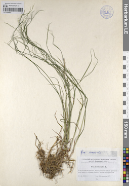
LE 01206843
Poa nemoralis L. det. Melnikov, Denis Germanovich at 03.06.2011
Collectors: Melnikov, Denis Germanovich Collection date: 03.06.2011. Administrative regions: RU - Udmurtskaya Respublika - Karakulinskiy Rayon. Groups of specimens: Образцы сектора Восточной Европы; Соглашение Минобрнауки №075-15-2021-1056; Флора Урала и прилегающих территорий (проект)Original label text:Удмуртская республика, Каракулинский район, примерно 3 км к западу от деревни Пинязь. Липняк неморальный.
Coordinates (geographic position): 56° 12′ 0.77″ N, 53° 37′ 5.19″ E ±500 mRecord creation: 2023-08-29, Artyom Borodushkin, PhotoScan D2.Citation: Specimen LE 01206843 // Virtual herbarium of Komarov Botanical Institute RAS — http://re.herbariumle.ru/01206843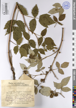
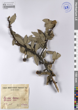
LE 01208795
Rubus idaeus L. ⟨Высота куста около 50 сантиметров. Плоды сладкие⟩ det. Busch at 06.08.1945
Collectors: Selivanova-Gorodkova, Elena Alexandrovna Collection date: 06.08.1945. Administrative regions: RU - Bashkortostan - Burzyanskiy Rayon. Groups of specimens: Образцы сектора Восточной Европы; Соглашение Минобрнауки №075-15-2021-1056; Plantae australiuralenses. E. A. Selivanova-Gorodkova.Original label text:Южный Урал. Башкирский Государственный Заповедник (57°43'-58°12' восточной долготы от Гринвича, 53°15'-53°30' северной широты). Южный Крака. Бассейн верхнего течения реки Белой. Окрестности усадьбы Башкирского Государственного Заповедника. Западный склон горы Кизыл-таш. По сухому каменистому руслу небольшими группами.
Record creation: 2023-08-30, Artyom Borodushkin, PhotoScan D2.Citation: Specimen LE 01208795 // Virtual herbarium of Komarov Botanical Institute RAS — http://re.herbariumle.ru/01208795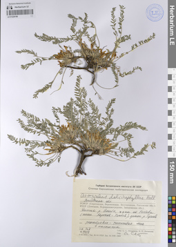
LE 01228199
Astragalus dolichophyllus Pall. det. Sytin, Andrej Kirillovich
Collectors: Ikonnikov, Sergei Sergeevich; Litvinova, N.P. Field collecting number: 5109. Collection date: 14.05.1971. Administrative regions: RU - Rostovskaya Oblast'. Place of collection: в 79 км от Ростова (шоссе Харьков - Ростов), долина р. Тузлов.Expedition: Степная Европейская геоботаническая экспедиция (1970 -1971)Groups of specimens: Образцы сектора Восточной Европы; Соглашение Минобрнауки №075-15-2021-1056; Гербарий Ботанического института АН СССРOriginal label text:Гербарий Ботанического института АН СССР
Степная Европейская геоботаническая экспедиция (1970 -1971)
Astragalus dolichophyllus Pall.
Ростовская обл. Долина р. Аюты, в 79 км от Ростова (шоссе Харьков - Ростов), долина р. Тузлов
асс. разнотравно-типчаковая степь с полынком
14.5.1971
№ 5109
Собр. С. С. Иконников, Н. П. Литвинова.
Опр. А. Сытин
Habitat / plant community in location of collecting: асс. разнотравно-типчаковая степь с полынкомRecord creation: 2023-08-31, Artyom Borodushkin, PhotoScan D2.Citation: Specimen LE 01228199 // Virtual herbarium of Komarov Botanical Institute RAS — http://re.herbariumle.ru/01228199Степная Европейская геоботаническая экспедиция (1970 -1971)
Astragalus dolichophyllus Pall.
Ростовская обл. Долина р. Аюты, в 79 км от Ростова (шоссе Харьков - Ростов), долина р. Тузлов
асс. разнотравно-типчаковая степь с полынком
14.5.1971
№ 5109
Собр. С. С. Иконников, Н. П. Литвинова.
Опр. А. Сытин
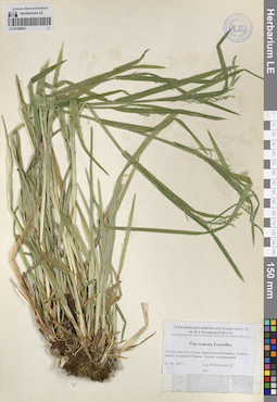
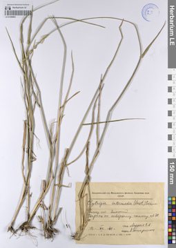
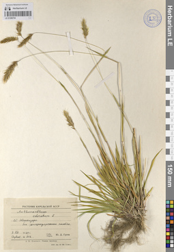
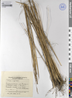
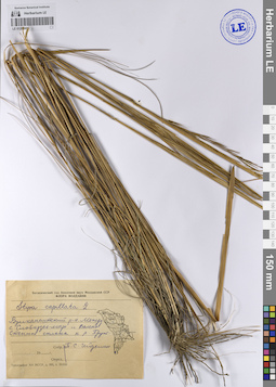
LE 01206841
Poa remota Forselles det. Melnikov, Denis Germanovich at 03.06.2011
Collectors: Melnikov, Denis Germanovich Collection date: 03.06.2011. Administrative regions: RU - Udmurtskaya Respublika - Karakulinskiy Rayon. Groups of specimens: Образцы сектора Восточной Европы; Соглашение Минобрнауки №075-15-2021-1056; Флора Урала и прилегающих территорий (проект)Original label text:Удмуртская республика, Каракулинский район, 3,5 км к западу от деревни Пинязь. Липняк неморальный.
Coordinates (geographic position): 56° 11′ 54.7″ N, 53° 36′ 35.23″ E ±500 mRecord creation: 2023-08-29, Artyom Borodushkin, PhotoScan D2.Citation: Specimen LE 01206841 // Virtual herbarium of Komarov Botanical Institute RAS — http://re.herbariumle.ru/01206841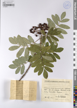
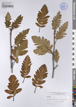
LE 01208793
Sorbus sp. det. Busch
Collectors: Vassiljev, Igor V.; Vasilyeva, N. N. Field collecting number: 22. Collection date: 29.07.1952. Administrative regions: RU - Samarskaya Oblast' - Stavropol'skiy Rayon. Groups of specimens: Образцы сектора Восточной Европы; Соглашение Минобрнауки №075-15-2021-1056; Гербарий Ботанического института АН СССРOriginal label text:Куйбышевская область, Жигулевский район. Смешанный лес по лощине. Южный склон. Близ Бахиловой Поляны. 200 метров
Coordinates (geographic position): 200 m a.s.l.Record creation: 2023-08-30, Artyom Borodushkin, PhotoScan D2.Citation: Specimen LE 01208793 // Virtual herbarium of Komarov Botanical Institute RAS — http://re.herbariumle.ru/01208793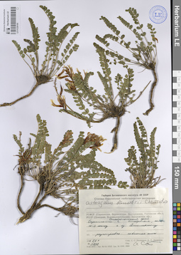
LE 01228195
Astragalus demetrii Kharadze det. Sytin, Andrej Kirillovich
Collectors: Litvinova, N.P. Field collecting number: 5222. Collection date: 22.05.1971. Administrative regions: RU - Stavropol'skiy Kray. Place of collection: Окрестности г. Ставрополя, склон ЮЗ экспоз. к оз. Сенгилеевскому.Expedition: Степная Европейская геоботаническая экспедиция (1970 -1971)Groups of specimens: Образцы сектора Восточной Европы; Соглашение Минобрнауки №075-15-2021-1056; Гербарий Ботанического института АН СССРOriginal label text:Гербарий Ботанического института АН СССР
Степная Европейская геоботаническая экспедиция (1970 -1971)
Astragalus demetrii Charadze
Ставропольский край. Окрестности г. Ставрополя, склон ЮЗ экспоз. к оз. Сенгилеевскому.
разнотравно-ковыльная степь.
22.5.1971
№ 5222
Собр. Н. П. Литвинова.
Опр. А. Сытин
Habitat / plant community in location of collecting: разнотравно-ковыльная степьRecord creation: 2023-08-31, Artyom Borodushkin, PhotoScan D2.Citation: Specimen LE 01228195 // Virtual herbarium of Komarov Botanical Institute RAS — http://re.herbariumle.ru/01228195Степная Европейская геоботаническая экспедиция (1970 -1971)
Astragalus demetrii Charadze
Ставропольский край. Окрестности г. Ставрополя, склон ЮЗ экспоз. к оз. Сенгилеевскому.
разнотравно-ковыльная степь.
22.5.1971
№ 5222
Собр. Н. П. Литвинова.
Опр. А. Сытин
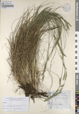
LE 01206840
Festuca sp. det. Melnikov, Denis Germanovich at 03.06.2011
Collectors: Melnikov, Denis Germanovich Collection date: 03.06.2011. Administrative regions: RU - Tatarstan - Agryzskiy Rayon. Groups of specimens: Образцы сектора Восточной Европы; Соглашение Минобрнауки №075-15-2021-1056; Флора Урала и прилегающих территорий (проект)Original label text:Республика Татарстан, Агрызский район, сосняк на левом берегу реки Бимы, примерно 2 км от устья.
Coordinates (geographic position): 56° 14′ 14.63″ N, 53° 33′ 18.68″ E ±500 mRecord creation: 2023-08-29, Artyom Borodushkin, PhotoScan D2.Citation: Specimen LE 01206840 // Virtual herbarium of Komarov Botanical Institute RAS — http://re.herbariumle.ru/01206840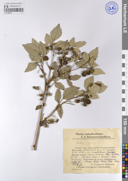
LE 01208791
Rubus idaeus L. ⟨Высота куста около 50 сантиметров. Плоды сладкие⟩ det. Busch at 06.08.1945
Collectors: Selivanova-Gorodkova, Elena Alexandrovna Collection date: 06.08.1945. Administrative regions: RU - Bashkortostan - Burzyanskiy Rayon. Groups of specimens: Образцы сектора Восточной Европы; Соглашение Минобрнауки №075-15-2021-1056; Plantae australiuralenses. E. A. Selivanova-Gorodkova.Original label text:Южный Урал. Башкирский Государственный Заповедник (57°43'-58°12' восточной долготы от Гринвича, 53°15'-53°30' северной широты). Южный Крака. Бассейн верхнего течения реки Белой. Окрестности усадьбы Башкирского Государственного Заповедника. Западный склон горы Кизыл-таш. По сухому каменистому руслу небольшими группами.
Record creation: 2023-08-30, Artyom Borodushkin, PhotoScan D2.Citation: Specimen LE 01208791 // Virtual herbarium of Komarov Botanical Institute RAS — http://re.herbariumle.ru/01208791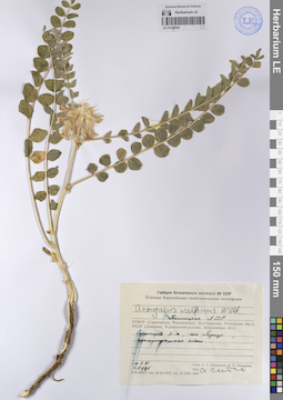
LE 01228194
Astragalus vulpinus Willd. det. Sytin, Andrej Kirillovich
Collectors: Ikonnikov, Sergei Sergeevich; Litvinova, N.P. Field collecting number: 5626. Collection date: 09.06.1971. Administrative regions: RU - Kalmykiya - Sarpinskiy Rayon. Place of collection: пос. Гаджур.Expedition: Степная Европейская геоботаническая экспедиция (1970 -1971)Groups of specimens: Образцы сектора Восточной Европы; Соглашение Минобрнауки №075-15-2021-1056; Гербарий Ботанического института АН СССРOriginal label text:Гербарий Ботанического института АН СССР
Степная Европейская геоботаническая экспедиция (1970 -1971)
Astragalus vulpinus Willd.
Калмыцкая АССР. Сарпинский р-н, пос. Гаджур
псаммофитная степь
9.6.1971
№ 5626
Собр. С. С. Иконников, Н. П. Литвинова.
Опр. А. Сытин
Habitat / plant community in location of collecting: псаммофитная степьRecord creation: 2023-08-31, Artyom Borodushkin, PhotoScan D2.Citation: Specimen LE 01228194 // Virtual herbarium of Komarov Botanical Institute RAS — http://re.herbariumle.ru/01228194Степная Европейская геоботаническая экспедиция (1970 -1971)
Astragalus vulpinus Willd.
Калмыцкая АССР. Сарпинский р-н, пос. Гаджур
псаммофитная степь
9.6.1971
№ 5626
Собр. С. С. Иконников, Н. П. Литвинова.
Опр. А. Сытин
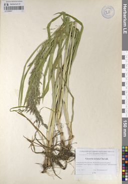
LE 01206837
Glyceria notata Chevall. det. Melnikov, Denis Germanovich at 12.06.2011
Collectors: Melnikov, Denis Germanovich Collection date: 12.06.2011. Administrative regions: RUUdmurtskaya Respublika - Yakshur-Bod'inskiy Rayon. Groups of specimens: Образцы сектора Восточной Европы; Соглашение Минобрнауки №075-15-2021-1056; Флора Урала и прилегающих территорий (проект)Original label text:Удмуртская республика, Якшур-Бодьинский район, примерно 3 км к западу от деревни Кургальск. Заболоченная вырубка.
Coordinates (geographic position): 57° 12′ 32.67″ N, 52° 47′ 46.65″ E ±500 mRecord creation: 2023-08-29, Artyom Borodushkin, PhotoScan D2.Citation: Specimen LE 01206837 // Virtual herbarium of Komarov Botanical Institute RAS — http://re.herbariumle.ru/01206837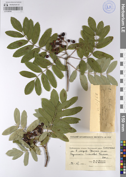
LE 01208789
Collectors: Vassiljev, Igor V.; Vasilyeva, N. N. Collection date: 29.07.1952. Administrative regions: RU - Samarskaya Oblast' - Stavropol'skiy Rayon. Groups of specimens: Образцы сектора Восточной Европы; Соглашение Минобрнауки №075-15-2021-1056; Гербарий Ботанического института АН СССРOriginal label text:
Куйбышевская область. Жигулевский район. Смешанный лес в лощине. Южный склон. Окрестности Бахиловой Поляны. 200 метров
Coordinates (geographic position): 200 m a.s.l.Record creation: 2023-08-30, Artyom Borodushkin, PhotoScan D2.Citation: Specimen LE 01208789 // Virtual herbarium of Komarov Botanical Institute RAS — http://re.herbariumle.ru/01208789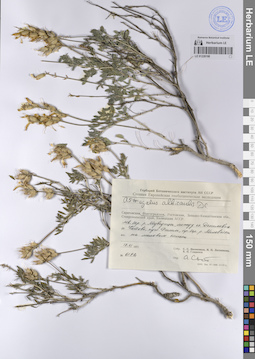
LE 01228190
Astragalus albicaulis DC. det. Sytin, Andrej Kirillovich
Collectors: Ikonnikov, Sergei Sergeevich; Litvinova, N.P.; Gladkova, Valentina Nikolaevna Field collecting number: 6192. Collection date: 18.06.1971. Administrative regions: RU - Volgogradskaya Oblast'. Place of collection: Лев. берег р. Медведицы, между сс. Даниловка и Котово, хут. Филин, пр. бер. р. Меловатки.Expedition: Степная Европейская геоботаническая экспедиция (1970 -1971)Groups of specimens: Образцы сектора Восточной Европы; Соглашение Минобрнауки №075-15-2021-1056; Гербарий Ботанического института АН СССРOriginal label text:Гербарий Ботанического института АН СССР
Степная Европейская геоботаническая экспедиция (1970 -1971)
Astragalus albicaulis DC
Волгоградская обл.
Лев. берег р. Медведицы, между сс. Даниловка и Котово, хут. Филин, пр. бер. р. Меловатки
на меловом склоне
18.6.1971
№ 6192
Собр. С. С. Иконников, Н. П. Литвинова, В. Н. Гладкова.
Опр. А. Сытин
Habitat / plant community in location of collecting: на меловом склонеRecord creation: 2023-08-31, Artyom Borodushkin, PhotoScan D2.Citation: Specimen LE 01228190 // Virtual herbarium of Komarov Botanical Institute RAS — http://re.herbariumle.ru/01228190Степная Европейская геоботаническая экспедиция (1970 -1971)
Astragalus albicaulis DC
Волгоградская обл.
Лев. берег р. Медведицы, между сс. Даниловка и Котово, хут. Филин, пр. бер. р. Меловатки
на меловом склоне
18.6.1971
№ 6192
Собр. С. С. Иконников, Н. П. Литвинова, В. Н. Гладкова.
Опр. А. Сытин
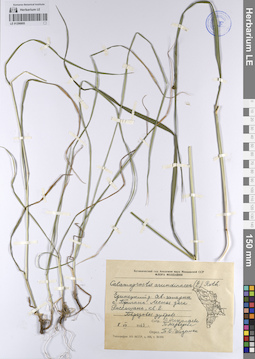
LE 01206805
Calamagrostis arundinacea (L.) Roth det. Gejdeman, Tatyana Sergeevna
Collectors: Nikolaeva, L.; Medvedeva, T. Collection date: 08.07.1963. Administrative regions: MD - Raionul Edinet. Groups of specimens: Образцы сектора Восточной Европы; Соглашение Минобрнауки №075-15-2021-1056; Флора МолдавииOriginal label text:Единецкий район. Северо-западнее села Бриганы [?]. Лесная дача Россошань, квадрат 2. Березовая дубрава.
Record creation: 2023-08-29, Artyom Borodushkin, PhotoScan D2.Citation: Specimen LE 01206805 // Virtual herbarium of Komarov Botanical Institute RAS — http://re.herbariumle.ru/01206805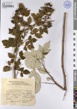
LE 01208787
Rubus idaeus L. det. Selivanova-Gorodkova, Elena Alexandrovna at 28.08.1945
Collectors: Selivanova-Gorodkova, Elena Alexandrovna Collection date: 28.08.1945. Administrative regions: RU - Bashkortostan - Burzyanskiy Rayon. Groups of specimens: Образцы сектора Восточной Европы; Соглашение Минобрнауки №075-15-2021-1056; Plantae australiuralenses. E. A. Selivanova-Gorodkova.Original label text:Южный Урал. Башкирский Государственный Заповедник (57°43'-58°12' восточной долготы от Гринвича, 53°15'-53°30' северной широты). Южный Крака. Окрестности усадьбы Башкирского Государственного Заповедника. Северо-восточный склон горы Алакбер (около 800 метров над уровнем моря) У основания склона Изредка.
Coordinates (geographic position): 800 m a.s.l.Record creation: 2023-08-30, Artyom Borodushkin, PhotoScan D2.Citation: Specimen LE 01208787 // Virtual herbarium of Komarov Botanical Institute RAS — http://re.herbariumle.ru/01208787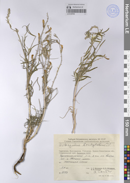
LE 01228186
Astragalus brachylobus Fisch. ex DC. det. Sytin, Andrej Kirillovich
Collectors: Litvinova, N.P. Field collecting number: 5573. Collection date: 05.06.1971. Administrative regions: RU - Kalmykiya - Chernozemel'skiy Rayon. Place of collection: 2 км на восток от п. Светлый.Expedition: Степная Европейская геоботаническая экспедиция (1970 -1971)Groups of specimens: Образцы сектора Восточной Европы; Соглашение Минобрнауки №075-15-2021-1056; Гербарий Ботанического института АН СССРOriginal label text:Гербарий Ботанического института АН СССР
Степная Европейская геоботаническая экспедиция (1970 -1971)
Astragalus brachylobus Fisch. ex DC.
Калмыцкая АССР. Черноземельский р-н, 2 км на восток от п. Светлый, пески
песчаная степь
5.6.1971
№ 5573
Собр. Н. П. Литвинова.
Опр. А. Сытин
Habitat / plant community in location of collecting: песчаная степьRecord creation: 2023-08-31, Artyom Borodushkin, PhotoScan D2.Citation: Specimen LE 01228186 // Virtual herbarium of Komarov Botanical Institute RAS — http://re.herbariumle.ru/01228186Степная Европейская геоботаническая экспедиция (1970 -1971)
Astragalus brachylobus Fisch. ex DC.
Калмыцкая АССР. Черноземельский р-н, 2 км на восток от п. Светлый, пески
песчаная степь
5.6.1971
№ 5573
Собр. Н. П. Литвинова.
Опр. А. Сытин
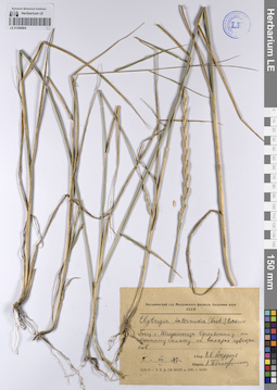
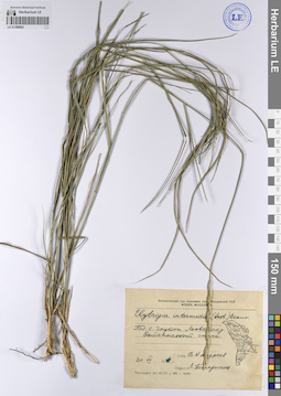
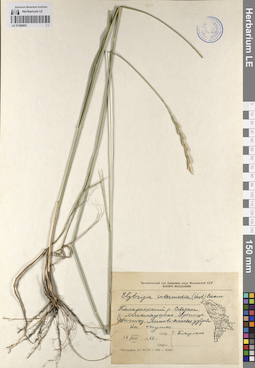
LE 01206804
Elytrigia intermedia (Host) Nevski det. Pozharisskaya, Lidiya Petrovna
Collectors: Andreev, V. N. Collection date: 05.08.1947. Administrative regions: MD - Soldanesti. Groups of specimens: Образцы сектора Восточной Европы; Соглашение Минобрнауки №075-15-2021-1056; Флора МолдавииOriginal label text:Близ села Шолданешты Оргеевского уезда по степному склону на выходах известняков.
Coordinates (geographic position): 47° 48′ 48.7″ N, 28° 47′ 31.73″ E ±2000 mRecord creation: 2023-08-29, Artyom Borodushkin, PhotoScan D2.Citation: Specimen LE 01206804 // Virtual herbarium of Komarov Botanical Institute RAS — http://re.herbariumle.ru/01206804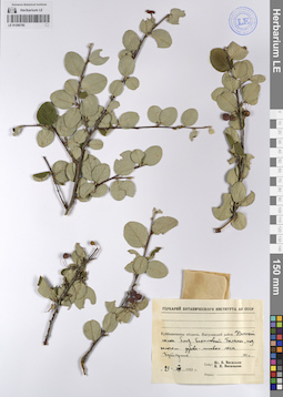
LE 01208785
Collectors: Vassiljev, Igor V.; Vasilyeva, N. N. Collection date: 29.07.1952. Administrative regions: RU - Samarskaya Oblast' - Stavropol'skiy Rayon. Groups of specimens: Образцы сектора Восточной Европы; Соглашение Минобрнауки №075-15-2021-1056; Гербарий Ботанического института АН СССРOriginal label text:
Куйбышевская область. Жигулевский район. Южный склон близ Бахиловой Поляны, под пологом дубово-липового леса. Кустарник. 100 метров
Coordinates (geographic position): 100 m a.s.l.Record creation: 2023-08-30, Artyom Borodushkin, PhotoScan D2.Citation: Specimen LE 01208785 // Virtual herbarium of Komarov Botanical Institute RAS — http://re.herbariumle.ru/01208785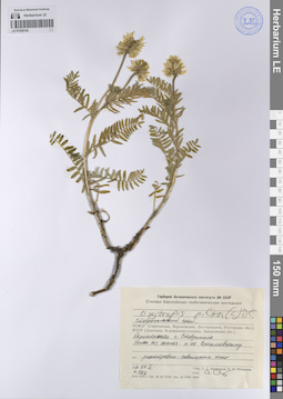
LE 01228182
Oxytropis pilosa (L.) DC. det. Sytin, Andrej Kirillovich
Collectors: Ikonnikov, Sergei Sergeevich; Litvinova, N.P. Field collecting number: 5216. Collection date: 22.05.1971. Administrative regions: RU - Stavropol'skiy Kray. Place of collection: Склон ЮЗ экспозиции к оз. Сенгилеевскому..Expedition: Степная Европейская геоботаническая экспедиция (1970 -1971)Groups of specimens: Образцы сектора Восточной Европы; Соглашение Минобрнауки №075-15-2021-1056; Гербарий Ботанического института АН СССРOriginal label text:Гербарий Ботанического института АН СССР
Степная Европейская геоботаническая экспедиция (1970 -1971)
Oxytropis pilosa (L.) DC.
Ставропольский край. Окрестности г. Ставрополя.
Склон ЮЗ экспозиции к оз. Сенгилеевскому.
разнотравно-ковыльная степь.
22.5.1971
№ 5216
Собр. С. С. Иконников, Н. П. Литвинова.
Опр. А. Сытин
Habitat / plant community in location of collecting: разнотравно-ковыльная степьRecord creation: 2023-08-31, Artyom Borodushkin, PhotoScan D2.Citation: Specimen LE 01228182 // Virtual herbarium of Komarov Botanical Institute RAS — http://re.herbariumle.ru/01228182Степная Европейская геоботаническая экспедиция (1970 -1971)
Oxytropis pilosa (L.) DC.
Ставропольский край. Окрестности г. Ставрополя.
Склон ЮЗ экспозиции к оз. Сенгилеевскому.
разнотравно-ковыльная степь.
22.5.1971
№ 5216
Собр. С. С. Иконников, Н. П. Литвинова.
Опр. А. Сытин
LE 01206803
Elytrigia intermedia (Host) Nevski det. Pozharisskaya, Lidiya Petrovna
Collectors: Andreev, V. N. Collection date: 19.08.1949. Administrative regions: MD - Cimislia. Groups of specimens: Образцы сектора Восточной Европы; Соглашение Минобрнауки №075-15-2021-1056; Флора МолдавииOriginal label text:Близ села Злотий [Злоць]. Гырнец [?] по северному склону, кв. 78.
Coordinates (geographic position): 46° 41′ 45.67″ N, 28° 53′ 50.1″ E ±1000 mRecord creation: 2023-08-29, Artyom Borodushkin, PhotoScan D2.Citation: Specimen LE 01206803 // Virtual herbarium of Komarov Botanical Institute RAS — http://re.herbariumle.ru/01206803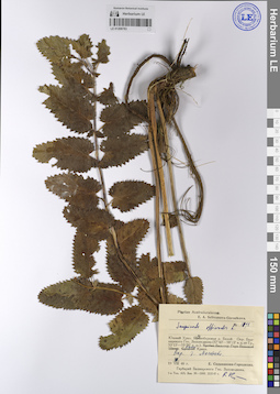
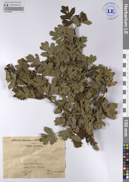
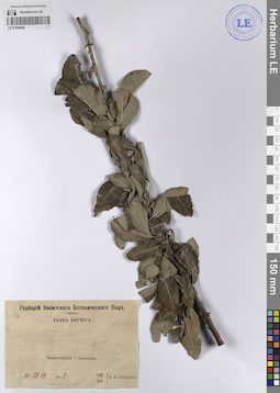
LE 01208783
Sanguisorba officinalis L. det. Busch
Collectors: Selivanova-Gorodkova, Elena Alexandrovna Field collecting number: 1098. Collection date: 04.08.1946. Administrative regions: RU - Bashkortostan - Burzyanskiy Rayon. Groups of specimens: Образцы сектора Восточной Европы; Соглашение Минобрнауки №075-15-2021-1056; Plantae australiuralenses. E. A. Selivanova-Gorodkova.Original label text:Южный Урал. Левобережье реки белой. Окрестности Башкирского Государственного Заповедника (57°43'-58°12' восточной долготы от Гринвича, 53°15'-53°30' северной широты). Южный Крака. Окрестности деревни Магадеево.
Record creation: 2023-08-30, Artyom Borodushkin, PhotoScan D2.Citation: Specimen LE 01208783 // Virtual herbarium of Komarov Botanical Institute RAS — http://re.herbariumle.ru/01208783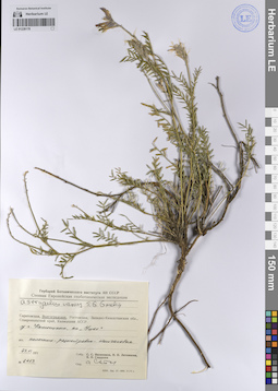
LE 01228178
Astragalus varius S.G. Gmel. det. Sytin, Andrej Kirillovich
Collectors: Ikonnikov, Sergei Sergeevich; Litvinova, N.P.; Gladkova, Valentina Nikolaevna Field collecting number: 6453. Collection date: 23.06.1971. Administrative regions: RU - Volgogradskaya Oblast'. Place of collection: У г. Камышина, на "Ушах".Expedition: Степная Европейская геоботаническая экспедиция (1970 -1971)Groups of specimens: Образцы сектора Восточной Европы; Соглашение Минобрнауки №075-15-2021-1056; Гербарий Ботанического института АН СССРOriginal label text:Гербарий Ботанического института АН СССР
Степная Европейская геоботаническая экспедиция (1970 -1971)
Astragalus varius S.G. Gmel.
Волгоградская обл.
У г. Камышина, на "Ушах"
асс. полынно-разнотравно-типчаковая
23.6.1971
№ 6453
Собр. С. С. Иконников, Н. П. Литвинова, В. Н. Гладкова.
Опр. А. Сытин
Habitat / plant community in location of collecting: асс. полынно-разнотравно-типчаковаяRecord creation: 2023-08-31, Artyom Borodushkin, PhotoScan D2.Citation: Specimen LE 01228178 // Virtual herbarium of Komarov Botanical Institute RAS — http://re.herbariumle.ru/01228178Степная Европейская геоботаническая экспедиция (1970 -1971)
Astragalus varius S.G. Gmel.
Волгоградская обл.
У г. Камышина, на "Ушах"
асс. полынно-разнотравно-типчаковая
23.6.1971
№ 6453
Собр. С. С. Иконников, Н. П. Литвинова, В. Н. Гладкова.
Опр. А. Сытин
LE 01206802
Elytrigia intermedia (Host) Nevski det. Pozharisskaya, Lidiya Petrovna
Collectors: Andreev, V. N. Collection date: 20.07.1948. Administrative regions: MD - Pridnestrovian Moldavian Republic. Groups of specimens: Образцы сектора Восточной Европы; Соглашение Минобрнауки №075-15-2021-1056; Флора МолдавииOriginal label text:Близ села Гыртоп Леовского района. Остепненный склон.
Coordinates (geographic position): 47° 14′ 30.94″ N, 29° 21′ 26.03″ E ±2000 mRecord creation: 2023-08-29, Artyom Borodushkin, PhotoScan D2.Citation: Specimen LE 01206802 // Virtual herbarium of Komarov Botanical Institute RAS — http://re.herbariumle.ru/01206802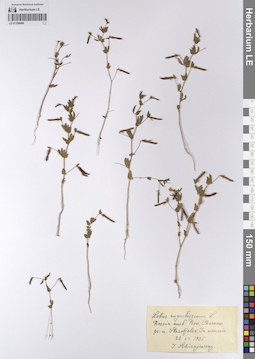
LE 01208686
Lotus angustissimus L. det. Schirajewsky, Ivan I. at 23.07.1905
Collectors: Schirajewsky, Ivan I. Collection date: 23.07.1905. Administrative regions: UA - Luhans'ka Oblast'. Groups of specimens: Образцы сектора Восточной Европы; Соглашение Минобрнауки №075-15-2021-1056Original label text:Rossia australis. Prov. Charkow, prope urb. Starobjelsk. In arenosis. (Юг России. Харьковская губерния, у города Старобельска. На песке.)
Record creation: 2023-08-30, Artyom Borodushkin, PhotoScan D2.Citation: Specimen LE 01208686 // Virtual herbarium of Komarov Botanical Institute RAS — http://re.herbariumle.ru/01208686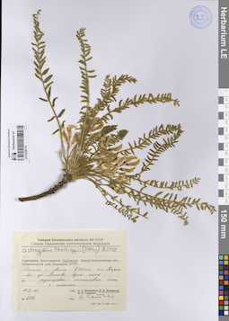
LE 01228174
Astragalus henningii (Steven) Boriss. det. Sytin, Andrej Kirillovich
Collectors: Litvinova, N.P. Field collecting number: 5110. Collection date: 14.05.1971. Administrative regions: RU - Rostovskaya Oblast'. Place of collection: Долина р. Аюты, в 79 км от Харькова до Ростова вдоль шоссе.Expedition: Степная Европейская геоботаническая экспедиция (1970 -1971)Groups of specimens: Образцы сектора Восточной Европы; Соглашение Минобрнауки №075-15-2021-1056; Гербарий Ботанического института АН СССРOriginal label text:Гербарий Ботанического института АН СССР
Степная Европейская геоботаническая экспедиция (1970 -1971)
Astragalus henningii (Steven) Boriss.
Ростовская обл. Долина р. Аюты, в 79 км от Харькова до Ростова вдоль шоссе
асс. разнотравно-типчаковая степь с полынком
14.5.1971
№ 5110
Собр. Н. П. Литвинова.
Опр. А. Сытин
Habitat / plant community in location of collecting: асс. разнотравно-типчаковая степь с полынкомRecord creation: 2023-08-31, Artyom Borodushkin, PhotoScan D2.Citation: Specimen LE 01228174 // Virtual herbarium of Komarov Botanical Institute RAS — http://re.herbariumle.ru/01228174Степная Европейская геоботаническая экспедиция (1970 -1971)
Astragalus henningii (Steven) Boriss.
Ростовская обл. Долина р. Аюты, в 79 км от Харькова до Ростова вдоль шоссе
асс. разнотравно-типчаковая степь с полынком
14.5.1971
№ 5110
Собр. Н. П. Литвинова.
Опр. А. Сытин
LE 01206801
Elytrigia intermedia (Host) Nevski det. Postolake, Georgiy Gavrilovich at 16.08.1966
Collectors: Postolake, Georgiy Gavrilovich Collection date: 16.08.1966. Administrative regions: MD - Raionul Straseni. Groups of specimens: Образцы сектора Восточной Европы; Соглашение Минобрнауки №075-15-2021-1056; Флора МолдавииOriginal label text:Каларашский район, севернее села Миклаушены, урочище Вкэтэу. Липово-ясеневая дубрава, на опушке.
Coordinates (geographic position): 47° 7′ 40.53″ N, 28° 18′ 37.49″ E ±2000 mRecord creation: 2023-08-29, Artyom Borodushkin, PhotoScan D2.Citation: Specimen LE 01206801 // Virtual herbarium of Komarov Botanical Institute RAS — http://re.herbariumle.ru/01206801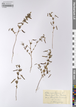
LE 01208685
Lotus angustissimus L. det. Schirajewsky, Ivan I. at 23.07.1905
Collectors: Schirajewsky, Ivan I. Collection date: 23.07.1905. Administrative regions: UA - Luhans'ka Oblast'. Groups of specimens: Образцы сектора Восточной Европы; Соглашение Минобрнауки №075-15-2021-1056Original label text:Rossia australis. Prov. Charkow, prope urb. Starobjelsk. In arenosis. (Юг России. Харьковская губерния, у города Старобельска. На песке.)
Record creation: 2023-08-30, Artyom Borodushkin, PhotoScan D2.Citation: Specimen LE 01208685 // Virtual herbarium of Komarov Botanical Institute RAS — http://re.herbariumle.ru/01208685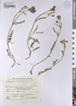
LE 01228170
Astragalus onobrychis L. det. Sytin, Andrej Kirillovich
Collectors: Litvinova, N.P. Field collecting number: 5192. Collection date: 27.05.1971. Administrative regions: RU - Stavropol'skiy Kray. Place of collection: 48 км от г. Ставрополя по шоссе на Изобильное.Expedition: Степная Европейская геоботаническая экспедиция (1970 -1971)Groups of specimens: Образцы сектора Восточной Европы; Соглашение Минобрнауки №075-15-2021-1056; Гербарий Ботанического института АН СССРOriginal label text:Гербарий Ботанического института АН СССР
Степная Европейская геоботаническая экспедиция (1970 -1971)
Astragalus onobrychis L.
Ставропольский край. 48 км от г. Ставрополя по шоссе на Изобильное.
асс. типчаково-разнотравная степь с Salvia nutans.
27.5.1971
№ 5192
Собр. Н. П. Литвинова.
Опр. А. Сытин
Habitat / plant community in location of collecting: асс. типчаково-разнотравная степь с Salvia nutansRecord creation: 2023-08-31, Artyom Borodushkin, PhotoScan D2.Citation: Specimen LE 01228170 // Virtual herbarium of Komarov Botanical Institute RAS — http://re.herbariumle.ru/01228170Степная Европейская геоботаническая экспедиция (1970 -1971)
Astragalus onobrychis L.
Ставропольский край. 48 км от г. Ставрополя по шоссе на Изобильное.
асс. типчаково-разнотравная степь с Salvia nutans.
27.5.1971
№ 5192
Собр. Н. П. Литвинова.
Опр. А. Сытин
LE 01206768
Sorbus sp.
Collectors: Zaikonnikova, Tamara Ivanovna Collection date: 1971. Administrative regions: RU - Sankt-Peterburg - Petrogradskiy Rayon. Groups of specimens: Образцы сектора Восточной Европы; Соглашение Минобрнауки №075-15-2021-1056Original label text:Ленинград, парк БИН, за беседкой. Маленькое деревцо.
Coordinates (geographic position): 59° 58′ 8.91″ N, 30° 19′ 43.01″ E ±50 mRecord creation: 2023-08-29, Artyom Borodushkin, PhotoScan D2.Citation: Specimen LE 01206768 // Virtual herbarium of Komarov Botanical Institute RAS — http://re.herbariumle.ru/01206768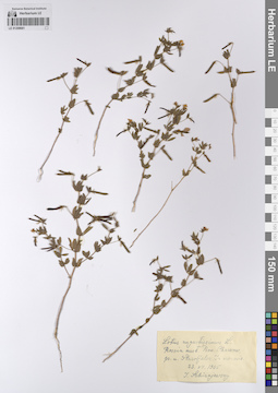
LE 01208681
Lotus angustissimus L. det. Schirajewsky, Ivan I. at 23.07.1905
Collectors: Schirajewsky, Ivan I. Collection date: 23.07.1905. Administrative regions: UA - Luhans'ka Oblast'. Groups of specimens: Образцы сектора Восточной Европы; Соглашение Минобрнауки №075-15-2021-1056Original label text:Rossia australis. Prov. Charkow, prope urb. Starobjelsk. In arenosis. (Юг России. Харьковская губерния, у города Старобельска. На песке.)
Record creation: 2023-08-30, Artyom Borodushkin, PhotoScan D2.Citation: Specimen LE 01208681 // Virtual herbarium of Komarov Botanical Institute RAS — http://re.herbariumle.ru/01208681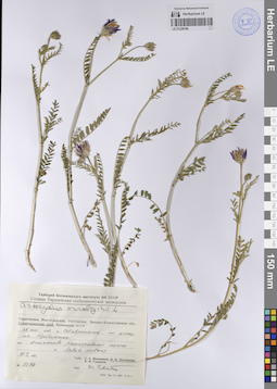
LE 01228166
Astragalus onobrychis L. det. Sytin, Andrej Kirillovich
Collectors: Litvinova, N.P. Field collecting number: 5192. Collection date: 21.05.1971. Administrative regions: RU - Stavropol'skiy Kray. Place of collection: 48 км от г. Ставрополя по шоссе на Изобильное.Expedition: Степная Европейская геоботаническая экспедиция (1970 -1971)Groups of specimens: Образцы сектора Восточной Европы; Соглашение Минобрнауки №075-15-2021-1056; Гербарий Ботанического института АН СССРOriginal label text:Гербарий Ботанического института АН СССР
Степная Европейская геоботаническая экспедиция (1970 -1971)
Astragalus onobrychis L.
Ставропольский край. 48 км от г. Ставрополя по шоссе на Изобильное.
асс. типчаково-разнотравная степь с Salvia nutans.
21.5.1971
№ 5192
Собр. Н. П. Литвинова.
Опр. А. Се...
Habitat / plant community in location of collecting: асс. типчаково-разнотравная степь с Salvia nutansRecord creation: 2023-08-31, Artyom Borodushkin, PhotoScan D2.Citation: Specimen LE 01228166 // Virtual herbarium of Komarov Botanical Institute RAS — http://re.herbariumle.ru/01228166Степная Европейская геоботаническая экспедиция (1970 -1971)
Astragalus onobrychis L.
Ставропольский край. 48 км от г. Ставрополя по шоссе на Изобильное.
асс. типчаково-разнотравная степь с Salvia nutans.
21.5.1971
№ 5192
Собр. Н. П. Литвинова.
Опр. А. Се...
LE 01206704
Anthoxanthum odoratum L. det. Gusev, Yuriy Dmitrievich at 07.08.1969
Collectors: Gusev, Yuriy Dmitrievich Field collecting number: 316. Collection date: 07.08.1969. Administrative regions: RU - Respublika Kareliya - Kaleval'skiy Rayon. Groups of specimens: Образцы сектора Восточной Европы; Соглашение Минобрнауки №075-15-2021-1056; Растения Карельской АССРOriginal label text:Станция Юшкозеро. На железнодорожном полотне.
Coordinates (geographic position): 64° 46′ 13.57″ N, 32° 13′ 52.83″ E ±1000 mRecord creation: 2023-08-29, Artyom Borodushkin, PhotoScan D2.Citation: Specimen LE 01206704 // Virtual herbarium of Komarov Botanical Institute RAS — http://re.herbariumle.ru/01206704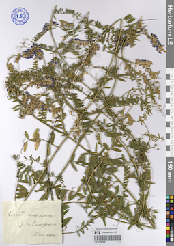
LE 01208596
Collectors: Busch Collection date: 05.07.1968. Administrative regions: RU - Russian Federation. Groups of specimens: Образцы сектора Восточной Европы; Соглашение Минобрнауки №075-15-2021-1056Original label text:
Лесной питомник у села Синодского
Record creation: 2023-08-30, Artyom Borodushkin, PhotoScan D2.Citation: Specimen LE 01208596 // Virtual herbarium of Komarov Botanical Institute RAS — http://re.herbariumle.ru/01208596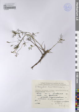
LE 01228162
Astragalus austriacus Jacq. det. Sytin, Andrej Kirillovich
Collectors: Litvinova, N.P. Field collecting number: 5174. Collection date: 21.05.1971. Administrative regions: RU - Stavropol'skiy Kray. Place of collection: 48 км от г. Ставрополя по шоссе на Изобильное.Expedition: Степная Европейская геоботаническая экспедиция (1970 -1971)Groups of specimens: Образцы сектора Восточной Европы; Соглашение Минобрнауки №075-15-2021-1056; Гербарий Ботанического института АН СССРOriginal label text:Гербарий Ботанического института АН СССР
Степная Европейская геоботаническая экспедиция (1970 -1971)
Astragalus austriacus L.
Ставропольский край. 48 км от г. Ставрополя по шоссе на Изобильное.
асс. злаково-разнотравная с полынком и ромашником
21.5.1971
№ 5174
Собр. Н. П. Литвинова.
Опр. А. Се...
Habitat / plant community in location of collecting: асс. злаково-разнотравная с полынком и ромашникомRecord creation: 2023-08-31, Artyom Borodushkin, PhotoScan D2.Citation: Specimen LE 01228162 // Virtual herbarium of Komarov Botanical Institute RAS — http://re.herbariumle.ru/01228162Степная Европейская геоботаническая экспедиция (1970 -1971)
Astragalus austriacus L.
Ставропольский край. 48 км от г. Ставрополя по шоссе на Изобильное.
асс. злаково-разнотравная с полынком и ромашником
21.5.1971
№ 5174
Собр. Н. П. Литвинова.
Опр. А. Се...
LE 01206667
Stipa capillata L. det. Gejdeman, Tatyana Sergeevna
Collectors: Gejdeman, Tatyana Sergeevna Administrative regions: MD - Raionul Cahul. Groups of specimens: Образцы сектора Восточной Европы; Соглашение Минобрнауки №075-15-2021-1056Original label text:Вулканештский район. Между селами Слободзея-маре [Слобозия-Маре] и Валено [Вэлень]. Степные склоны к реке Прут.
Coordinates (geographic position): 45° 37′ 12.03″ N, 28° 6′ 30.29″ E ±5000 mRecord creation: 2023-08-29, Artyom Borodushkin, PhotoScan D2.Citation: Specimen LE 01206667 // Virtual herbarium of Komarov Botanical Institute RAS — http://re.herbariumle.ru/01206667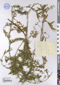
LE 01208595
Collectors: Busch Collection date: 05.07.1968. Administrative regions: RU - Russian Federation. Groups of specimens: Образцы сектора Восточной Европы; Соглашение Минобрнауки №075-15-2021-1056Original label text:
Лесной питомник у села Синодского
Record creation: 2023-08-30, Artyom Borodushkin, PhotoScan D2.Citation: Specimen LE 01208595 // Virtual herbarium of Komarov Botanical Institute RAS — http://re.herbariumle.ru/01208595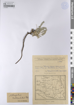
LE 01228157
Astragalus testiculatus Pall. det. Borissova, Antonina Georgievna
Collectors: Krascheninnikov, Ippolit (Hippolit) Mikhailovich; Afanasiev Field collecting number: 6131. Collection date: 14.07.1929. Administrative regions: RU - Bashkortostan. Place of collection: в 8 км от х. Богачевского (совр. пос. Богачёво) на р. Таналыке.Expedition: Башкирская Экспедиция Академии Наук. О.Э. Кнорринг, И.М. Крашенинников, С.Е. Кучеровская. Геоботанические исследования в Зилаирском кантоне (1928 -1929)Groups of specimens: Образцы сектора Восточной Европы; Соглашение Минобрнауки №075-15-2021-1056Original label text:О. Э. Кнорринг, И. М. Крашенинников и С. Е. Кучеровская. Геоботанические исследования в Зилаирском кантоне Башкирской республики.
№ 6131
Залаирский кантон.
Ковыльно-разнотравная степь склонов низин в 8 км от х. Богачевского на р. Таналыке.
14.7.1929
Собр. Крашенинников и Афанасьев
Plantae Bashkiricae
Astragalus testiculatus Pall.
Determ. Borissowa
Habitat / plant community in location of collecting: Ковыльно-разнотравная степь склонов низинRecord creation: 2023-08-31, Artyom Borodushkin, PhotoScan D2.Citation: Specimen LE 01228157 // Virtual herbarium of Komarov Botanical Institute RAS — http://re.herbariumle.ru/01228157№ 6131
Залаирский кантон.
Ковыльно-разнотравная степь склонов низин в 8 км от х. Богачевского на р. Таналыке.
14.7.1929
Собр. Крашенинников и Афанасьев
Plantae Bashkiricae
Astragalus testiculatus Pall.
Determ. Borissowa
LE 01206666
Stipa capillata L. det. Gejdeman, Tatyana Sergeevna
Collectors: Gejdeman, Tatyana Sergeevna Administrative regions: MD - Raionul Cahul. Groups of specimens: Образцы сектора Восточной Европы; Соглашение Минобрнауки №075-15-2021-1056; Флора МолдавииOriginal label text:Вулканештский район. Между селами Слободзея-маре [Слобозия-Маре] и Валено [Вэлень]. Степные склоны к реке Прут.
Coordinates (geographic position): 45° 37′ 12.03″ N, 28° 6′ 30.29″ E ±5000 mRecord creation: 2023-08-29, Artyom Borodushkin, PhotoScan D2.Citation: Specimen LE 01206666 // Virtual herbarium of Komarov Botanical Institute RAS — http://re.herbariumle.ru/01206666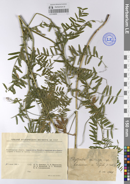
LE 01208594
Collectors: Lovelius, Olga L.; Mishenkova, Antonina Petrovna; Menitsky, Yuri Leonardovich; Tchelintzev, N.G.; Siplivinsky, Vladimir Nikolaevich Collection date: 03.07.1968. Administrative regions: RU - Volgogradskaya Oblast'. Groups of specimens: Образцы сектора Восточной Европы; Соглашение Минобрнауки №075-15-2021-1056; С.В. Юзепчук. Растения КрымаOriginal label text:
Волгоградская область. Дубравы в балках на границе Камышевского и Дубовского районов.
Record creation: 2023-08-30, Artyom Borodushkin, PhotoScan D2.Citation: Specimen LE 01208594 // Virtual herbarium of Komarov Botanical Institute RAS — http://re.herbariumle.ru/01208594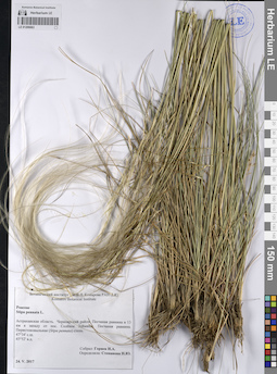
LE 01206663
Stipa pennata L. det. Stepanova, Nina Jurievna
Collectors: Goryaev, I. A. Collection date: 24.05.2017. Administrative regions: RU - Astrakhanskaya Oblast' - Chernoyarskiy Rayon. Groups of specimens: Образцы сектора Восточной Европы; Соглашение Минобрнауки №075-15-2021-1056Original label text:Астраханская область. Черноярский район. Песчаная равнина в 13 километрах к западу от поселка Солёное Займище. Песчаная равнина. Перистоковыльная (Stipa pennata) степь.
47°34' северной широты
45°52' восточной долготы
LE 01208593
Collectors: Mishenkova, Antonina Petrovna; Menitsky, Yuri Leonardovich; Siplivinsky, Vladimir Nikolaevich Collection date: 14.07.1968. Administrative regions: RU - Penzenskaya Oblast'. Groups of specimens: Образцы сектора Восточной Европы; Соглашение Минобрнауки №075-15-2021-1056; Гербарий Ботанического института АН СССРOriginal label text:
Пензенская область, село Курганное. Разнотравные луга по склонам оврага.
Record creation: 2023-08-30, Artyom Borodushkin, PhotoScan D2.Citation: Specimen LE 01208593 // Virtual herbarium of Komarov Botanical Institute RAS — http://re.herbariumle.ru/01208593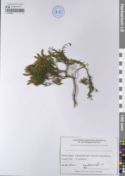
LE 01209967
Collectors: Agapova, N. D. Collection date: 16.06.1979. Administrative regions: UA - Republic of Crimea - Gorodskoy okrug Alushta. Place of collection: Гора Кастель.Groups of specimens: Образцы сектора Восточной Европы; Соглашение Минобрнауки №075-15-2021-1056; Гербарий Ботанического института им. В.Л. Комарова РАН (LE)Original label text:
Гербарий Ботанического института им. В.Л. Комарова РАН (LE)
Herbarium of the Komarova botanik institute
Россия, Крым. Городской округ Алушта. Гора Кастель.
N44,637794 Е34,384258
16.06.1979
Leg. Агапова Н.
"N44.637794 Е34.384258" - координаты в указанном формате рабочим листом ввода данных Гербария не воспринимаются
Record creation: 2023-08-31, Artyom Borodushkin, PhotoScan D2.Citation: Specimen LE 01209967 // Virtual herbarium of Komarov Botanical Institute RAS — http://re.herbariumle.ru/01209967Herbarium of the Komarova botanik institute
Россия, Крым. Городской округ Алушта. Гора Кастель.
N44,637794 Е34,384258
16.06.1979
Leg. Агапова Н.
LE 01206662
Collectors: Smirnova A. N. Collection date: 12.09.1918. Administrative regions: UA - Gorod Sevastopol - Balaklava District. Groups of specimens: Образцы сектора Восточной Европы; Соглашение Минобрнауки №075-15-2021-1056; Гербарий Императорского Никитского Сада. Флора Крыма.Original label text:
Георгиевский монастырь. Мраморная балка.
Coordinates (geographic position): 44° 30′ 7.52″ N, 33° 31′ 17.37″ E ±500 mRecord creation: 2023-08-29, Artyom Borodushkin, PhotoScan D2.Citation: Specimen LE 01206662 // Virtual herbarium of Komarov Botanical Institute RAS — http://re.herbariumle.ru/01206662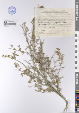
LE 01208585
Collectors: Ikonnikov, Sergei Sergeevich; Litvinova, N.P. Field collecting number: 4491. Collection date: 19.08.1970. Administrative regions: RU - Belgorodskaya Oblast' - Roven'skiy Rayon. Expedition: АН СССР Степная Европейская геоботаническая экспедиция ()Groups of specimens: Образцы сектора Восточной Европы; Соглашение Минобрнауки №075-15-2021-1056Original label text:
РСФСР (Белгородская область) Ровенский район правый берег реки Айдар у села Ровеньки ассоциация на мелах
Record creation: 2023-08-30, Artyom Borodushkin, PhotoScan D2.Citation: Specimen LE 01208585 // Virtual herbarium of Komarov Botanical Institute RAS — http://re.herbariumle.ru/01208585
LE 01209414
Hippocrepis comosa L.
Collectors: Podolnaya, L. P.; Efimova, E. V. Collection date: 26.06.1984. Administrative regions: UA - Republic of Crimea. Place of collection: близ шоссе Ялта - Севастополь, у поворота на пос. Орлиное.Groups of specimens: Образцы сектора Восточной Европы; Соглашение Минобрнауки №075-15-2021-1056; Гербарий Ботанического института им. В. Л. Комарова РАНOriginal label text:Гербарий Ботанического института им. В. Л. Комарова РАН
Hippocrepis comosa L.
Полуостров Крым,
близ шоссе Ялта - Севастополь, у поворота на пос. Орлиное, можжевеловый лес.
26.06.1984
Leg.: Л. П. Подольная, Е. В. Ефимова
Habitat / plant community in location of collecting: можжевеловый лесRecord creation: 2023-08-31, Artyom Borodushkin, PhotoScan D2.Citation: Specimen LE 01209414 // Virtual herbarium of Komarov Botanical Institute RAS — http://re.herbariumle.ru/01209414Hippocrepis comosa L.
Полуостров Крым,
близ шоссе Ялта - Севастополь, у поворота на пос. Орлиное, можжевеловый лес.
26.06.1984
Leg.: Л. П. Подольная, Е. В. Ефимова
LE 01206660
Collectors: Smirnova A. N. Collection date: 09.07.1919. Administrative regions: UA - Gorod Sevastopol - Balaklava District. Топоним: Биюк-Мускомия (Широкое). Groups of specimens: Образцы сектора Восточной Европы; Соглашение Минобрнауки №075-15-2021-1056; Гербарий Императорского Никитского Сада. Флора Крыма.Original label text:
Родник Таш-Чокрак, дервня Биюк-Мускомия
Coordinates (geographic position): 44° 29′ 57.5″ N, 33° 44′ 5.16″ E ±500 mRecord creation: 2023-08-29, Artyom Borodushkin, PhotoScan D2.Citation: Specimen LE 01206660 // Virtual herbarium of Komarov Botanical Institute RAS — http://re.herbariumle.ru/01206660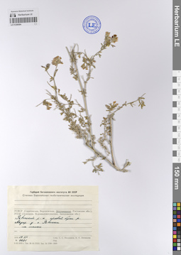
LE 01208584
Collectors: Ikonnikov, Sergei Sergeevich; Litvinova, N.P. Field collecting number: 4491. Collection date: 19.08.1970. Administrative regions: RU - Belgorodskaya Oblast' - Roven'skiy Rayon. Expedition: АН СССР Степная Европейская геоботаническая экспедиция ()Groups of specimens: Образцы сектора Восточной Европы; Соглашение Минобрнауки №075-15-2021-1056Original label text:
РСФСР (Белгородская область) Ровенский район правый берег реки Айдар у села Ровеньки ассоциация на мелах
Record creation: 2023-08-30, Artyom Borodushkin, PhotoScan D2.Citation: Specimen LE 01208584 // Virtual herbarium of Komarov Botanical Institute RAS — http://re.herbariumle.ru/01208584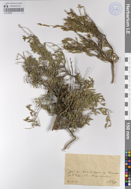
LE 01209035
Collection date: 26.07.1895. Administrative regions: RU - Orenburgskaya Oblast'. Place of collection: по дороге из Халиловой (на Б. Губерле) в с. Петропавловское.Groups of specimens: Образцы сектора Восточной Европы; Соглашение Минобрнауки №075-15-2021-1056Original label text:
Оренб. губ. Скалы по дороге из Халиловой (на Б. Губерле) в с. Петропавловское
26.7.1895
Ahst ?
Habitat / plant community in location of collecting: скалыRecord creation: 2023-08-31, Artyom Borodushkin, PhotoScan D2.Citation: Specimen LE 01209035 // Virtual herbarium of Komarov Botanical Institute RAS — http://re.herbariumle.ru/0120903526.7.1895
Ahst ?
LE 01206659
Collectors: Smirnova A. N. Collection date: 22.08.1919. Administrative regions: UA - Republic of Crimea - Gorodskoy okrug Feodosiya. Groups of specimens: Образцы сектора Восточной Европы; Соглашение Минобрнауки №075-15-2021-1056; Гербарий Императорского Никитского Сада. Флора Крыма.Original label text:
Кизильташский монастырь.
Coordinates (geographic position): 44° 56′ 0.28″ N, 35° 4′ 23.88″ E ±1500 mRecord creation: 2023-08-29, Artyom Borodushkin, PhotoScan D2.Citation: Specimen LE 01206659 // Virtual herbarium of Komarov Botanical Institute RAS — http://re.herbariumle.ru/01206659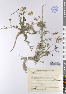
LE 01208583
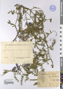
Lotus sp. det. Ikonnikov, Sergei Sergeevich, Litvinova, N.P. at 18.08.1970
Collectors: Ikonnikov, Sergei Sergeevich; Litvinova, N.P. Field collecting number: 4414. Collection date: 18.08.1970. Administrative regions: RU - Voronezhskaya Oblast' - Podgorenskiy Rayon. Expedition: АН СССР Степная Европейская геоботаническая экспедиция ()Groups of specimens: Образцы сектора Восточной Европы; Соглашение Минобрнауки №075-15-2021-1056Original label text:РСФСР (Воронежская область) Подгорненский район, у села Белогорка ассоциация на мелах
Record creation: 2023-08-30, Artyom Borodushkin, PhotoScan D2.Citation: Specimen LE 01208583 // Virtual herbarium of Komarov Botanical Institute RAS — http://re.herbariumle.ru/01208583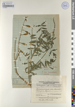
LE 01208912
Astragalus uralensis Litv.
Collectors: Kozhevnikov, Yury Pavlovich Collection date: 08.1968. Administrative regions: RU - Arkhangel'skaya Oblast' - Pinezhskiy Rayon. Place of collection: Кулой.Groups of specimens: Образцы сектора Восточной Европы; Соглашение Минобрнауки №075-15-2021-1056; Гербарий Ботанического Института Академии наук СССРOriginal label text:Гербарий Ботанического института Академии наук СССР
Astragalus uralensis Litv.
Архангельская область, Пинежский р-н, Кулой.
8.1968
Собр. Ю. Кожевников
Record creation: 2023-08-31, Artyom Borodushkin, PhotoScan D2.Citation: Specimen LE 01208912 // Virtual herbarium of Komarov Botanical Institute RAS — http://re.herbariumle.ru/01208912Astragalus uralensis Litv.
Архангельская область, Пинежский р-н, Кулой.
8.1968
Собр. Ю. Кожевников