View
Add
Copy
Edit
Delete
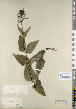
LE 01206689
Collectors: Knorring, Olga Evertovna Collection date: 08.1923. Administrative regions: RU - Leningradskaya Oblast' - Gatchinskiy Rayon. Groups of specimens: Образцы сектора Восточной Европы; Соглашение Минобрнауки №075-15-2021-1056Original label text:
Петроградская губерния Сиверская, деревня Большево. Сорная растительность в хлебах и картофели
Record creation: 2023-09-06, Artyom Borodushkin, PhotoScan D2.Citation: Specimen LE 01206689 // Virtual herbarium of Komarov Botanical Institute RAS — http://re.herbariumle.ru/01206689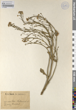
LE 01206688
Collectors: Busch Collection date: 10.05.1905. Administrative regions: RU - Republic of Crimea. Expedition: N. A. Busch, Iter Tauricum I. (1905)Groups of specimens: Образцы сектора Восточной Европы; Соглашение Минобрнауки №075-15-2021-1056Original label text:
Decliv. serpentr. Inter Theodosiam et Koktebel. Jaila. Litus meridion. (Между Феодосией и Коктебелем. Яйла.)
Record creation: 2023-09-06, Artyom Borodushkin, PhotoScan D2.Citation: Specimen LE 01206688 // Virtual herbarium of Komarov Botanical Institute RAS — http://re.herbariumle.ru/01206688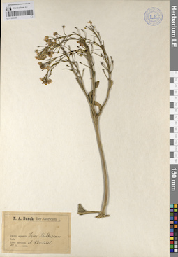
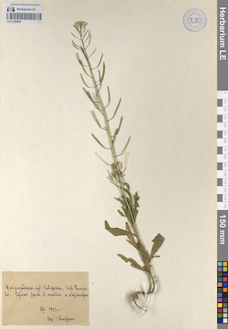
LE 01206687
Collectors: Busch Collection date: 10.05.1905. Administrative regions: RU - Republic of Crimea. Expedition: N. A. Busch, Iter Tauricum I. (1905)Groups of specimens: Образцы сектора Восточной Европы; Соглашение Минобрнауки №075-15-2021-1056Original label text:
Decliv. serpentr. Inter Theodosiam et Koktebel. Jaila. Litus meridion. (Между Феодосией и Коктебелем. Яйла.)
Record creation: 2023-09-06, Artyom Borodushkin, PhotoScan D2.Citation: Specimen LE 01206687 // Virtual herbarium of Komarov Botanical Institute RAS — http://re.herbariumle.ru/01206687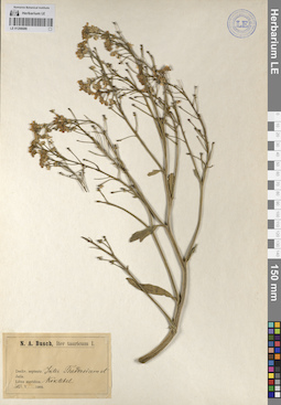
LE 01206686
Collectors: Busch Collection date: 10.05.1905. Administrative regions: RU - Republic of Crimea. Expedition: N. A. Busch, Iter Tauricum I. (1905)Groups of specimens: Образцы сектора Восточной Европы; Соглашение Минобрнауки №075-15-2021-1056Original label text:
Decliv. serpentr. Inter Theodosiam et Koktebel. Jaila. Litus meridion. (Между Феодосией и Коктебелем. Яйла.)
Record creation: 2023-09-06, Artyom Borodushkin, PhotoScan D2.Citation: Specimen LE 01206686 // Virtual herbarium of Komarov Botanical Institute RAS — http://re.herbariumle.ru/01206686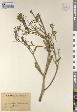
LE 01206685
Collectors: Busch Collection date: 10.05.1905. Administrative regions: RU - Republic of Crimea. Expedition: N. A. Busch, Iter Tauricum I. (1905)Groups of specimens: Образцы сектора Восточной Европы; Соглашение Минобрнауки №075-15-2021-1056Original label text:
Decliv. serpentr. Inter Theodosiam et Koktebel. Jaila. Litus meridion. (Между Феодосией и Коктебелем. Яйла.)
Record creation: 2023-09-06, Artyom Borodushkin, PhotoScan D2.Citation: Specimen LE 01206685 // Virtual herbarium of Komarov Botanical Institute RAS — http://re.herbariumle.ru/01206685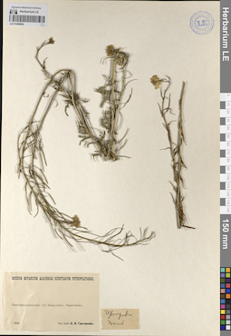
LE 01206684
Collectors: Busch Collection date: 1896. Administrative regions: UA - Donets'ka Oblast' - Bakhmut Raion. Groups of specimens: Образцы сектора Восточной Европы; Соглашение Минобрнауки №075-15-2021-1056; Museum Botanicum Academiae Scientiarum Petropolitanae; Гербарий Н. В. ГригорьеваOriginal label text:
Екатеринославская губерния Бахмутский уезд Черногорово.
Record creation: 2023-09-06, Artyom Borodushkin, PhotoScan D2.Citation: Specimen LE 01206684 // Virtual herbarium of Komarov Botanical Institute RAS — http://re.herbariumle.ru/01206684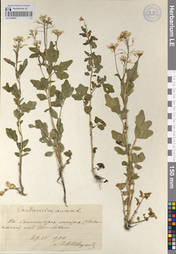
LE 01206683
Cardamine amara L. det. Schirjaev, I. at 29.04.1906
Collectors: Schirjaev, I. Collection date: 29.04.1906. Administrative regions: RU - Tambovskaya Oblast' - Tambovskiy Rayon. Groups of specimens: Образцы сектора Восточной Европы; Соглашение Минобрнауки №075-15-2021-1056Original label text:На болотистых местах (Водокачка) под Тамбовом.
Record creation: 2023-09-06, Artyom Borodushkin, PhotoScan D2.Citation: Specimen LE 01206683 // Virtual herbarium of Komarov Botanical Institute RAS — http://re.herbariumle.ru/01206683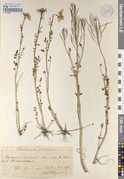
LE 01206682
Cardamine pratensis L. det. Schirjaev, I. at 08.05.1906
Collectors: Schirjaev, I. Collection date: 08.05.1906. Administrative regions: RU - Tambovskaya Oblast' - Tambovskiy Rayon. Groups of specimens: Образцы сектора Восточной Европы; Соглашение Минобрнауки №075-15-2021-1056Original label text:Окраины болота на лугу за Цной под Тамбовом.
Record creation: 2023-09-06, Artyom Borodushkin, PhotoScan D2.Citation: Specimen LE 01206682 // Virtual herbarium of Komarov Botanical Institute RAS — http://re.herbariumle.ru/01206682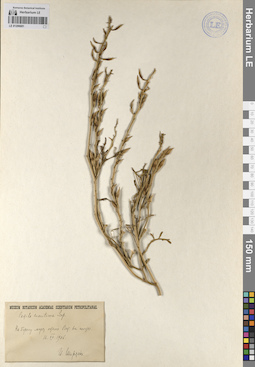
LE 01206681
Cakile maritima Scop. det. Schirjaev, I. at 16.07.1906
Collectors: Schirjaev, I. Collection date: 16.07.1906. Administrative regions: RU - Republic of Crimea. Groups of specimens: Образцы сектора Восточной Европы; Соглашение Минобрнауки №075-15-2021-1056; Museum Botanicum Academiae Scientiarum PetropolitanaeOriginal label text:На берегу моря около Сак. На песке.
Record creation: 2023-09-06, Artyom Borodushkin, PhotoScan D2.Citation: Specimen LE 01206681 // Virtual herbarium of Komarov Botanical Institute RAS — http://re.herbariumle.ru/01206681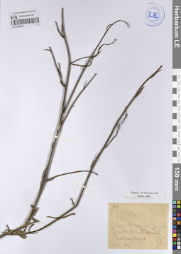
LE 01206538
Collectors: Poplavskaya (Poplawska), Henrietta Ippolitovna Field collecting number: 670. Collection date: 06.08.1932. Administrative regions: RU - Republic of Crimea. Expedition: Сборы Г. И. Поплавской Крым (1932 -1932)Groups of specimens: Образцы сектора Восточной Европы; Соглашение Минобрнауки №075-15-2021-1056Original label text:
Крым. Отуская долина Сунич в табачной плантации.
Record creation: 2023-09-06, Artyom Borodushkin, PhotoScan D2.Citation: Specimen LE 01206538 // Virtual herbarium of Komarov Botanical Institute RAS — http://re.herbariumle.ru/01206538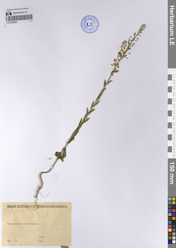
LE 01200288
Collectors: Busch Administrative regions: RU - Russian Federation. Groups of specimens: Образцы сектора Восточной Европы; Соглашение Минобрнауки №075-15-2021-1056; Гербарий Петергофского Естественно-Научного института Петроградского государств. университетаOriginal label text:
Ленинградская губерния Троцкий уезд
Record creation: 2023-09-06, Artyom Borodushkin, PhotoScan D2.Citation: Specimen LE 01200288 // Virtual herbarium of Komarov Botanical Institute RAS — http://re.herbariumle.ru/01200288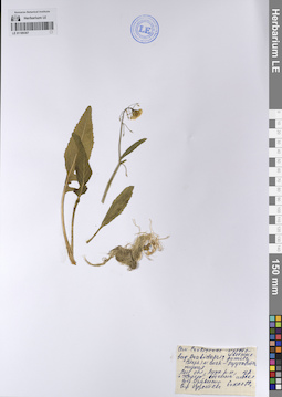
LE 01189307
Arabidopsis pumila (Stephan) N. Busch ⟨Семейство Cruciferae - Крестоцветные. вид - Резуховитка низкая.⟩ det. Kuropteva at 06.07.1976
Collectors: Krivenko Collection date: 06.07.1976. Administrative regions: RU - Leningradskaya Oblast' - Luzhskiy Rayon. Топоним: Геостанция РГПУ им. А. И. Герцена "Железо". Groups of specimens: Образцы сектора Восточной Европы; Соглашение Минобрнауки №075-15-2021-1056Original label text:Ленинградская область, Лужский район, урочище "Железо", обочина шоссе.
Coordinates (geographic position): 58° 55′ 47.21″ N, 29° 47′ 58.52″ E ±1500 mRecord creation: 2023-09-06, Artyom Borodushkin, PhotoScan D2.Citation: Specimen LE 01189307 // Virtual herbarium of Komarov Botanical Institute RAS — http://re.herbariumle.ru/01189307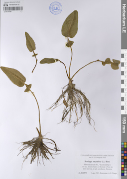
LE 01178160
Rorippa amphibia (L.) Besser det. Konechnaya, Galina Yurievna, Haare, Ado Oskarovich at 26.08.1973
Collectors: Konechnaya, Galina Yurievna; Haare, Ado Oskarovich Collection date: 26.08.1973. Administrative regions: RU - Novgorodskaya Oblast' - Chudovskiy Rayon. Groups of specimens: Образцы сектора Восточной Европы; Соглашение Минобрнауки №075-15-2021-1056; Гербарий Ботанического института им. В. Л. Комарова РАН (LE)Original label text:Новгородская область, Чудовский район от железнодорожного моста через реку Волхов 2,5 километра на юго-восток, ручей в пойме реки Волхов
Record creation: 2023-09-06, Artyom Borodushkin, PhotoScan D2.Citation: Specimen LE 01178160 // Virtual herbarium of Komarov Botanical Institute RAS — http://re.herbariumle.ru/01178160
LE 01178158
Erophila verna (L.) Besser det. Miniaev, Nikolai Aleksandrovich, Konechnaya, Galina Yurievna, Simachev, V. I. at 25.05.1973
Collectors: Miniaev, Nikolai Aleksandrovich; Konechnaya, Galina Yurievna; Simachev, V. I. Collection date: 25.05.1973. Administrative regions: RU - Leningradskaya Oblast' - Luzhskiy Rayon. Groups of specimens: Образцы сектора Восточной Европы; Соглашение Минобрнауки №075-15-2021-1056; Гербарий Ботанического института им. В. Л. Комарова РАН (LE)Original label text:Ленинградская область, Лужский район, окрестности города Луги, опушка сосняка.
Record creation: 2023-09-06, Artyom Borodushkin, PhotoScan D2.Citation: Specimen LE 01178158 // Virtual herbarium of Komarov Botanical Institute RAS — http://re.herbariumle.ru/01178158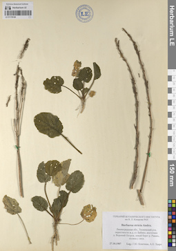
LE 01178128
Barbarea stricta Andrz. det. Konechnaya, Galina Yurievna, Haare, Ado Oskarovich at 27.10.1987
Collectors: Konechnaya, Galina Yurievna; Haare, Ado Oskarovich Collection date: 27.10.1987. Administrative regions: RU - Leningradskaya Oblast' - Tosnenskiy Rayon. Groups of specimens: Образцы сектора Восточной Европы; Соглашение Минобрнауки №075-15-2021-1056; Гербарий Ботанического института им. В. Л. Комарова РАН (LE)Original label text:Ленинградская область, Тосненский район, окрестности железнодорожной станции Бабино, восточнее деревни Вороний Остров, левый берег реки Равань, поляна у леса.
Record creation: 2023-09-06, Artyom Borodushkin, PhotoScan D2.Citation: Specimen LE 01178128 // Virtual herbarium of Komarov Botanical Institute RAS — http://re.herbariumle.ru/01178128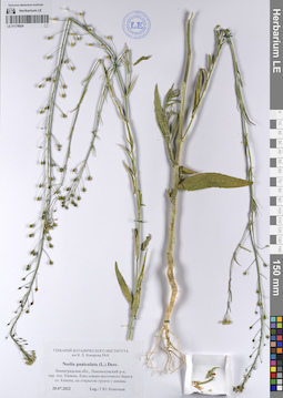
LE 01178024
Neslia paniculata (L.) Desv. det. Konechnaya, Galina Yurievna at 20.07.2022
Collectors: Konechnaya, Galina Yurievna Collection date: 20.07.2022. Administrative regions: RU - Leningradskaya Oblast' - Lomonosovskiy Rayon. Groups of specimens: Образцы сектора Восточной Европы; Соглашение Минобрнауки №075-15-2021-1056; Гербарий Ботанического института им. В. Л. Комарова РАН (LE)Original label text:Ленинградская область, Ломоносовский район, окрестности поселка Кипень, близ северо-восточного берега озера Кипень, на открытом грунте у канавы.
Record creation: 2023-09-06, Artyom Borodushkin, PhotoScan D2.Citation: Specimen LE 01178024 // Virtual herbarium of Komarov Botanical Institute RAS — http://re.herbariumle.ru/01178024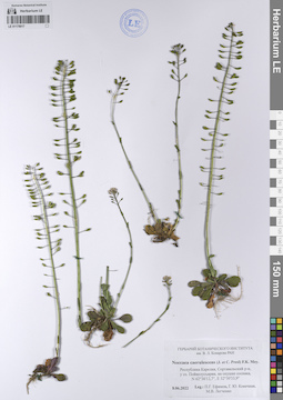
LE 01178017
Noccaea caerulescens (J. Presl & C. Presl) F.K. Mey. det. Efimov, Peter Gennadievich, Konechnaya, Galina Yurievna, Legchenko, Marina Vitaljevna at 08.06.2022
Collectors: Efimov, Peter Gennadievich; Konechnaya, Galina Yurievna; Legchenko, Marina Vitaljevna Collection date: 08.06.2022. Administrative regions: RU - Respublika Kareliya - Sortaval'skiy Rayon. Groups of specimens: Образцы сектора Восточной Европы; Соглашение Минобрнауки №075-15-2021-1056; Гербарий Ботанического института им. В. Л. Комарова РАН (LE)Original label text:Республика Карелия, Сортавальский район, у озера Пойкелусъярви, на опушке сосняка, N 62°36'12,7", E 32°30'33,9"
Coordinates (geographic position): 62° 36′ 12.7″ N, 32° 30′ 33.9″ ERecord creation: 2023-09-06, Artyom Borodushkin, PhotoScan D2.Citation: Specimen LE 01178017 // Virtual herbarium of Komarov Botanical Institute RAS — http://re.herbariumle.ru/01178017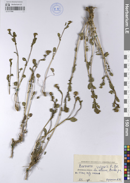
LE 01177984
Barbarea vulgaris R. Br. det. Doronina, Anna Yur'evna at 08.05.1994
Collectors: Doronina, Anna Yur'evna Collection date: 08.05.1994. Administrative regions: RU - Leningradskaya Oblast' - Vsevolozhskiy Rayon. Groups of specimens: Образцы сектора Восточной Европы; Соглашение Минобрнауки №075-15-2021-1056; Herbarium Universitatis LeninopolitanaeOriginal label text:Ленинградская область, Всеволожский район, платформа 54 километр, железнодорожная насыпь
Record creation: 2023-09-06, Artyom Borodushkin, PhotoScan D2.Citation: Specimen LE 01177984 // Virtual herbarium of Komarov Botanical Institute RAS — http://re.herbariumle.ru/01177984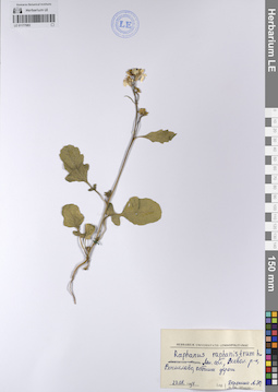
LE 01177983
Raphanus raphanistrum L. det. Doronina, Anna Yur'evna at 22.08.1994
Collectors: Doronina, Anna Yur'evna Collection date: 22.08.1994. Administrative regions: RU - Leningradskaya Oblast' - Vsevolozhskiy Rayon. Groups of specimens: Образцы сектора Восточной Европы; Соглашение Минобрнауки №075-15-2021-1056; Herbarium Universitatis LeninopolitanaeOriginal label text:Ленинградская область, Всеволожский район, Васкелово, обочина дороги
Record creation: 2023-09-06, Artyom Borodushkin, PhotoScan D2.Citation: Specimen LE 01177983 // Virtual herbarium of Komarov Botanical Institute RAS — http://re.herbariumle.ru/01177983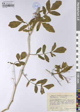
LE 01177969
Cardamine amara L. det. Doronina, Anna Yur'evna at 15.07.1998
Collectors: Doronina, Anna Yur'evna Collection date: 15.07.1998. Administrative regions: RU - Leningradskaya Oblast' - Priozersky Rayon. Groups of specimens: Образцы сектора Восточной Европы; Соглашение Минобрнауки №075-15-2021-1056; Herbarium Universitatis LeninopolitanaeOriginal label text:Ленинградская область, Приозерский район, примерно в 17 километрах от Лосево, южный берег Вуоксы, черноольшаник
Record creation: 2023-09-06, Artyom Borodushkin, PhotoScan D2.Citation: Specimen LE 01177969 // Virtual herbarium of Komarov Botanical Institute RAS — http://re.herbariumle.ru/01177969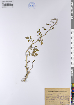
LE 01177968
Cardamine amara L. det. Doronina, Anna Yur'evna at 12.06.1998
Collectors: Doronina, Anna Yur'evna Collection date: 12.06.1998. Administrative regions: RU - Leningradskaya Oblast' - Priozersky Rayon. Groups of specimens: Образцы сектора Восточной Европы; Соглашение Минобрнауки №075-15-2021-1056; Herbarium Universitatis LeninopolitanaeOriginal label text:Ленинградская область, Приозерский район, Лосево, южный берег озера Суходольского, примерно в 1,5 километра от железной дороги
Record creation: 2023-09-06, Artyom Borodushkin, PhotoScan D2.Citation: Specimen LE 01177968 // Virtual herbarium of Komarov Botanical Institute RAS — http://re.herbariumle.ru/01177968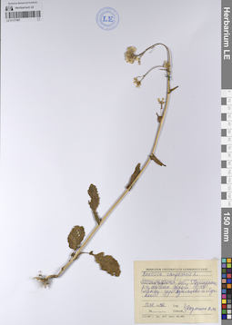
LE 01177967
Brassica campestris L. det. Doronina, Anna Yur'evna at 12.07.1998
Collectors: Doronina, Anna Yur'evna Collection date: 12.07.1998. Administrative regions: RU - Leningradskaya Oblast' - Priozersky Rayon. Groups of specimens: Образцы сектора Восточной Европы; Соглашение Минобрнауки №075-15-2021-1056; Herbarium Universitatis LeninopolitanaeOriginal label text:Ленинградская область, Приозерский район, обочина дороги P-31 между деревнями Удальцово и Луговое.
Record creation: 2023-09-06, Artyom Borodushkin, PhotoScan D2.Citation: Specimen LE 01177967 // Virtual herbarium of Komarov Botanical Institute RAS — http://re.herbariumle.ru/01177967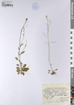
LE 01177966
Hylandra × suecica (Fr.) Á. Löve ⟨Arabidopsis thaliana (L.) Heynh. × Cardaminopsis arenosa (L.) Hayek⟩ det. Kolyagin, G. R. at 07.06.1996
Collectors: Doronina, Anna Yur'evna Collection date: 07.06.1996. Administrative regions: RU - Leningradskaya Oblast' - Priozersky Rayon. Groups of specimens: Образцы сектора Восточной Европы; Соглашение Минобрнауки №075-15-2021-1056; Herbarium Universitatis LeninopolitanaeOriginal label text:Ленинградская область, Приозерский район, поселок Мичуринское, обочина песчаной дороги
Record creation: 2023-09-06, Artyom Borodushkin, PhotoScan D2.Citation: Specimen LE 01177966 // Virtual herbarium of Komarov Botanical Institute RAS — http://re.herbariumle.ru/01177966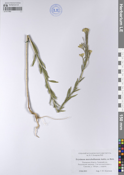
LE 01177962
Erysimum marschallianum Andrz. det. Konechnaya, Galina Yurievna at 19.06.2022
Collectors: Konechnaya, Galina Yurievna Collection date: 19.06.2022. Administrative regions: RU - Pskovskaya Oblast' - Gdovskiy Rayon. Groups of specimens: Образцы сектора Восточной Европы; Соглашение Минобрнауки №075-15-2021-1056; Гербарий Ботанического института им. В. Л. Комарова РАН (LE)Original label text:Псковская область, Гдовский район, Ремдовский заказник, 2 километра юго-восточнее деревни Самолва, деревня Таборы, у дороги
Record creation: 2023-09-06, Artyom Borodushkin, PhotoScan D2.Citation: Specimen LE 01177962 // Virtual herbarium of Komarov Botanical Institute RAS — http://re.herbariumle.ru/01177962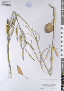
LE 01177961
Brassica napus L. det. Konechnaya, Galina Yurievna at 12.07.2013
Collectors: Konechnaya, Galina Yurievna Collection date: 12.07.2013. Administrative regions: RU - Pskovskaya Oblast' - Sebezhskiy Rayon. Groups of specimens: Образцы сектора Восточной Европы; Соглашение Минобрнауки №075-15-2021-1056; Гербарий Ботанического института им. В. Л. Комарова РАН (LE)Original label text:Псковская область, Себежский район, национальный парк "Себежский", деревня Илово, обочина дороги/
Record creation: 2023-09-06, Artyom Borodushkin, PhotoScan D2.Citation: Specimen LE 01177961 // Virtual herbarium of Komarov Botanical Institute RAS — http://re.herbariumle.ru/01177961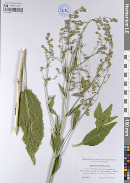
LE 01177899
Lepidium latifolium L. det. Konechnaya, Galina Yurievna at 06.08.2022
Collectors: Konechnaya, Galina Yurievna Collection date: 06.08.2022. Administrative regions: RU - Sankt-Peterburg - Krasnosel'skiy Rayon. Groups of specimens: Образцы сектора Восточной Европы; Соглашение Минобрнауки №075-15-2021-1056; Гербарий Ботанического института им. В. Л. Комарова РАН (LE)Original label text:Город Санкт-Петербург, Красносельский район, Южно-Приморский парк, нарушенный участок с кустами ивы на лугу близ улицы Доблести.
Record creation: 2023-09-06, Artyom Borodushkin, PhotoScan D2.Citation: Specimen LE 01177899 // Virtual herbarium of Komarov Botanical Institute RAS — http://re.herbariumle.ru/01177899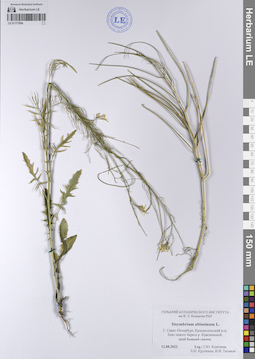
LE 01177894
Sisymbrium altissimum L. det. Konechnaya, Galina Yurievna, Krupkina, Lyudmila Ivanovna, Tatanov, Ivan Vladimirovich at 12.08.2022
Collectors: Konechnaya, Galina Yurievna; Krupkina, Lyudmila Ivanovna; Tatanov, Ivan Vladimirovich Collection date: 12.08.2022. Administrative regions: RU - Sankt-Peterburg - Krasnosel'skiy Rayon. Groups of specimens: Образцы сектора Восточной Европы; Соглашение Минобрнауки №075-15-2021-1056; Гербарий Ботанического института им. В. Л. Комарова РАН (LE)Original label text:Город Санкт-Петербург, Красносельский район, близ левого берега реки Красненькой, край бывшей свалки.
Record creation: 2023-09-06, Artyom Borodushkin, PhotoScan D2.Citation: Specimen LE 01177894 // Virtual herbarium of Komarov Botanical Institute RAS — http://re.herbariumle.ru/01177894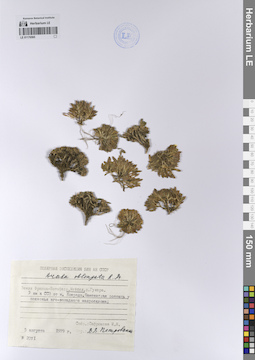
LE 01176565
Draba oblongata R. Br. det. Petrovsky, Vladislav Vladimirovich at 05.08.1979
Collectors: Safronova, Irina Nikolayevna Field collecting number: 2071. Collection date: 05.08.1979. Administrative regions: RU - Arkhangel'skaya Oblast' - Primorskiy Rayon. Expedition: Полярная экспедиция БИН АН СССР (1979)Groups of specimens: Образцы сектора Восточной Европы; Соглашение Минобрнауки №075-15-2021-1056Original label text:Земля Франца-Иосифа: остров Мейбел. 3 километра к северо-северо-западу от мыса Конрада. Каменистая россыпь у подножья юго-западного макросклона.
Record creation: 2023-09-06, Artyom Borodushkin, PhotoScan D2.Citation: Specimen LE 01176565 // Virtual herbarium of Komarov Botanical Institute RAS — http://re.herbariumle.ru/01176565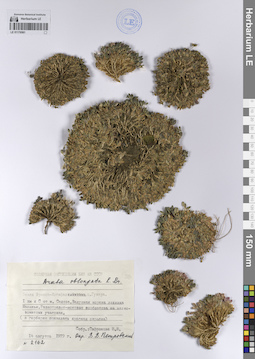
LE 01176561
Draba oblongata R. Br. ⟨в гербарии появилась красная окраска⟩ det. Petrovsky, Vladislav Vladimirovich at 14.08.1979
Collectors: Safronova, Irina Nikolayevna Field collecting number: 2162. Collection date: 14.08.1979. Administrative regions: RU - Arkhangel'skaya Oblast' - Primorskiy Rayon. Expedition: Полярная экспедиция БИН АН СССР (1979)Groups of specimens: Образцы сектора Восточной Европы; Соглашение Минобрнауки №075-15-2021-1056Original label text:Земля Франца-Иосифа: остров Гукера. 1 километр к северу от мыса Седова. Валунная морена ледника Маланьи. Разнотравно-моховые сообщества на мелкоземистых участках.
Record creation: 2023-09-06, Artyom Borodushkin, PhotoScan D2.Citation: Specimen LE 01176561 // Virtual herbarium of Komarov Botanical Institute RAS — http://re.herbariumle.ru/01176561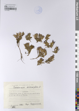
LE 01176538
Cardamine bellidifolia L. det. Safronova, Irina Nikolayevna at 11.08.1979
Collectors: Safronova, Irina Nikolayevna Field collecting number: 2123. Collection date: 11.08.1979. Administrative regions: RU - Arkhangel'skaya Oblast' - Primorskiy Rayon. Expedition: Полярная экспедиция БИН АН СССР (1979)Groups of specimens: Образцы сектора Восточной Европы; Соглашение Минобрнауки №075-15-2021-1056Original label text:Земля Франца-Иосифа: остров Гукера. Базальтовая осыпь на макросклоне южной экспозиции в 1,5 километре к востоку от мыса Седова.
Record creation: 2023-09-06, Artyom Borodushkin, PhotoScan D2.Citation: Specimen LE 01176538 // Virtual herbarium of Komarov Botanical Institute RAS — http://re.herbariumle.ru/01176538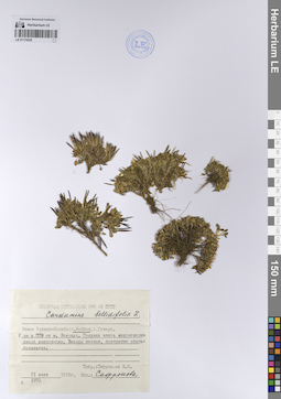
LE 01176525
Cardamine bellidifolia L. det. Safronova, Irina Nikolayevna at 21.07.1979
Collectors: Safronova, Irina Nikolayevna Field collecting number: 1970. Collection date: 21.07.1979. Administrative regions: RU - Arkhangel'skaya Oblast' - Primorskiy Rayon. Expedition: Полярная экспедиция БИН АН СССР (1979)Groups of specimens: Образцы сектора Восточной Европы; Соглашение Минобрнауки №075-15-2021-1056Original label text:Земля Франца-Иосифа: остров Мейбел. 2 километра к северо-северо-востоку от мыса Конрада. Средняя часть макросклона южной экспозиции. Выходы песков, прикрытые осыпью базальтов.
Record creation: 2023-09-06, Artyom Borodushkin, PhotoScan D2.Citation: Specimen LE 01176525 // Virtual herbarium of Komarov Botanical Institute RAS — http://re.herbariumle.ru/01176525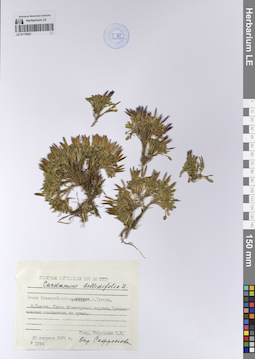
LE 01176521
Cardamine bellidifolia L. det. Safronova, Irina Nikolayevna at 20.08.1979
Collectors: Safronova, Irina Nikolayevna Field collecting number: 2214. Collection date: 20.08.1979. Administrative regions: RU - Arkhangel'skaya Oblast' - Primorskiy Rayon. Expedition: Полярная экспедиция БИН АН СССР (1979)Groups of specimens: Образцы сектора Восточной Европы; Соглашение Минобрнауки №075-15-2021-1056Original label text:Земля Франца-Иосифа: остров Гукера. Мыс Седова. Склон 40-метровой террасы. Травяно-моховые сообщества по ручью.
Record creation: 2023-09-06, Artyom Borodushkin, PhotoScan D2.Citation: Specimen LE 01176521 // Virtual herbarium of Komarov Botanical Institute RAS — http://re.herbariumle.ru/01176521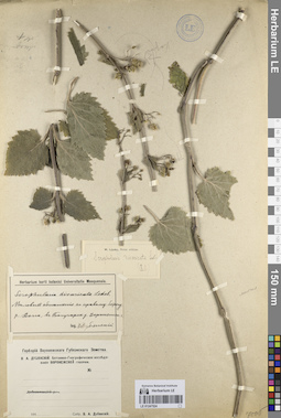
LE 01247524
Scrophularia divaricata Ledeb.
Groups of specimens: Образцы сектора Восточной Европы; Соглашение Минобрнауки №075-15-2021-1056Record creation: 2023-09-06, Mariya Sheludyakova, PhotoScan D2.Citation: Specimen LE 01247524 // Virtual herbarium of Komarov Botanical Institute RAS — http://re.herbariumle.ru/01247524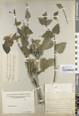
LE 01247523
Scrophularia divaricata Ledeb.
Groups of specimens: Образцы сектора Восточной Европы; Соглашение Минобрнауки №075-15-2021-1056Record creation: 2023-09-06, Mariya Sheludyakova, PhotoScan D2.Citation: Specimen LE 01247523 // Virtual herbarium of Komarov Botanical Institute RAS — http://re.herbariumle.ru/01247523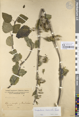
LE 01247522
Scrophularia divaricata Ledeb.
Groups of specimens: Образцы сектора Восточной Европы; Соглашение Минобрнауки №075-15-2021-1056Record creation: 2023-09-06, Mariya Sheludyakova, PhotoScan D2.Citation: Specimen LE 01247522 // Virtual herbarium of Komarov Botanical Institute RAS — http://re.herbariumle.ru/01247522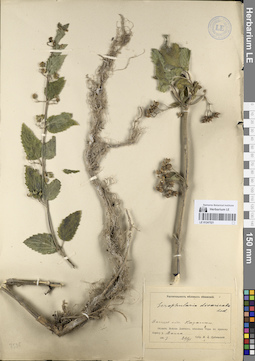
LE 01247521
Scrophularia divaricata Ledeb.
Groups of specimens: Образцы сектора Восточной Европы; Соглашение Минобрнауки №075-15-2021-1056Record creation: 2023-09-06, Mariya Sheludyakova, PhotoScan D2.Citation: Specimen LE 01247521 // Virtual herbarium of Komarov Botanical Institute RAS — http://re.herbariumle.ru/01247521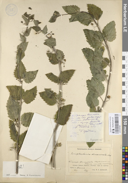
LE 01247520
Scrophularia divaricata Ledeb.
Groups of specimens: Образцы сектора Восточной Европы; Соглашение Минобрнауки №075-15-2021-1056Record creation: 2023-09-06, Mariya Sheludyakova, PhotoScan D2.Citation: Specimen LE 01247520 // Virtual herbarium of Komarov Botanical Institute RAS — http://re.herbariumle.ru/01247520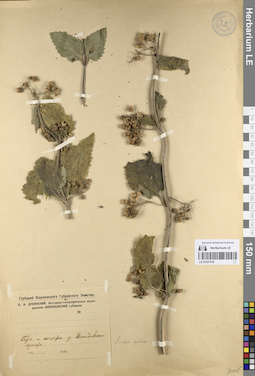
LE 01247519
Scrophularia divaricata Ledeb.
Groups of specimens: Образцы сектора Восточной Европы; Соглашение Минобрнауки №075-15-2021-1056Record creation: 2023-09-06, Mariya Sheludyakova, PhotoScan D2.Citation: Specimen LE 01247519 // Virtual herbarium of Komarov Botanical Institute RAS — http://re.herbariumle.ru/01247519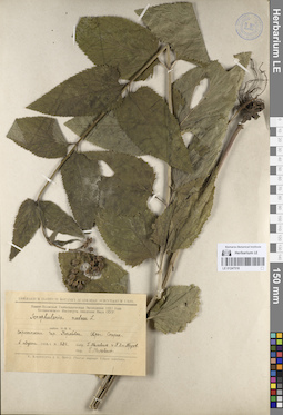
LE 01247518
Scrophularia nodosa L.
Groups of specimens: Образцы сектора Восточной Европы; Соглашение Минобрнауки №075-15-2021-1056Record creation: 2023-09-06, Mariya Sheludyakova, PhotoScan D2.Citation: Specimen LE 01247518 // Virtual herbarium of Komarov Botanical Institute RAS — http://re.herbariumle.ru/01247518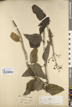
LE 01247517
Scrophularia nodosa L.
Groups of specimens: Образцы сектора Восточной Европы; Соглашение Минобрнауки №075-15-2021-1056Record creation: 2023-09-06, Mariya Sheludyakova, PhotoScan D2.Citation: Specimen LE 01247517 // Virtual herbarium of Komarov Botanical Institute RAS — http://re.herbariumle.ru/01247517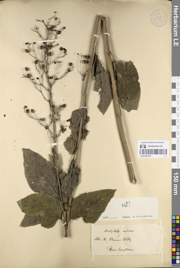
LE 01247516
Scrophularia nodosa L.
Groups of specimens: Образцы сектора Восточной Европы; Соглашение Минобрнауки №075-15-2021-1056Record creation: 2023-09-06, Mariya Sheludyakova, PhotoScan D2.Citation: Specimen LE 01247516 // Virtual herbarium of Komarov Botanical Institute RAS — http://re.herbariumle.ru/01247516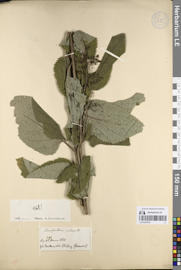
LE 01247515
Scrophularia nodosa L.
Additional identifications: Scrophularia nodosa L. det. Gorshkova, Sofia Gennadievna at 1951 Collectors: Becker, Alexander K. Field collecting number: 294. Collection date: 1871. Administrative regions: RU - Saratovskaya Oblast' - Krasnoarmeyskiy Rayon. Топоним: ШИЛЛИНГ (Schilling) (с. Сосновка Красноармейского района Саратовской области, немецкая колония). Groups of specimens: Образцы сектора Восточной Европы; Соглашение Минобрнауки №075-15-2021-1056Original label text:Scrophularia nodosa L.
Coordinates (geographic position): 51° 11′ 19.08″ N, 45° 47′ 8.29″ E ±10000 mRecord creation: 2023-09-06, Mariya Sheludyakova, PhotoScan D2.Citation: Specimen LE 01247515 // Virtual herbarium of Komarov Botanical Institute RAS — http://re.herbariumle.ru/01247515294
Leg. Al. Becker 1871
Gub. Saratow, colon. Schilling (Sosnovka)
LE 01247514
Scrophularia nodosa L.
Field collecting number: 167. Groups of specimens: Образцы сектора Восточной Европы; Соглашение Минобрнауки №075-15-2021-1056Record creation: 2023-09-06, Mariya Sheludyakova, PhotoScan D2.Citation: Specimen LE 01247514 // Virtual herbarium of Komarov Botanical Institute RAS — http://re.herbariumle.ru/01247514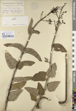
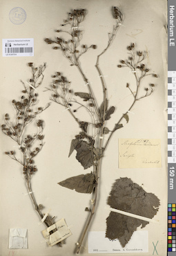
LE 01247513
Scrophularia nodosa L.
Groups of specimens: Образцы сектора Восточной Европы; Соглашение Минобрнауки №075-15-2021-1056Record creation: 2023-09-06, Mariya Sheludyakova, PhotoScan D2.Citation: Specimen LE 01247513 // Virtual herbarium of Komarov Botanical Institute RAS — http://re.herbariumle.ru/01247513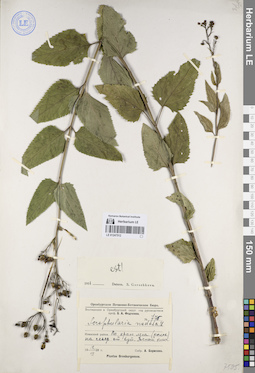
LE 01247512
Scrophularia nodosa L.
Groups of specimens: Образцы сектора Восточной Европы; Соглашение Минобрнауки №075-15-2021-1056Record creation: 2023-09-06, Mariya Sheludyakova, PhotoScan D2.Citation: Specimen LE 01247512 // Virtual herbarium of Komarov Botanical Institute RAS — http://re.herbariumle.ru/01247512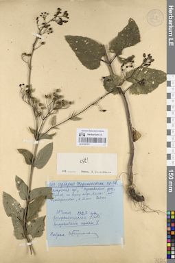
LE 01247511
Scrophularia nodosa L.
Groups of specimens: Образцы сектора Восточной Европы; Соглашение Минобрнауки №075-15-2021-1056Record creation: 2023-09-06, Mariya Sheludyakova, PhotoScan D2.Citation: Specimen LE 01247511 // Virtual herbarium of Komarov Botanical Institute RAS — http://re.herbariumle.ru/01247511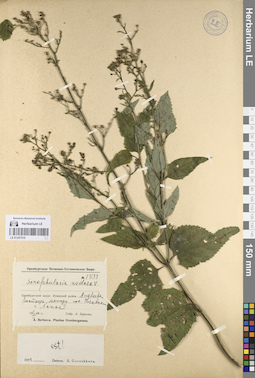
LE 01247510
Scrophularia nodosa L.
Groups of specimens: Образцы сектора Восточной Европы; Соглашение Минобрнауки №075-15-2021-1056Record creation: 2023-09-06, Mariya Sheludyakova, PhotoScan D2.Citation: Specimen LE 01247510 // Virtual herbarium of Komarov Botanical Institute RAS — http://re.herbariumle.ru/01247510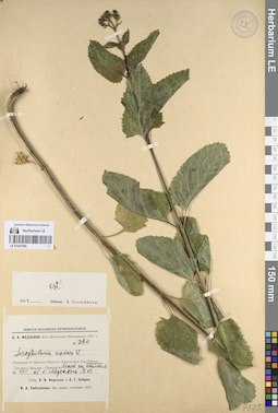
LE 01247509
Scrophularia nodosa L.
Groups of specimens: Образцы сектора Восточной Европы; Соглашение Минобрнауки №075-15-2021-1056Record creation: 2023-09-06, Mariya Sheludyakova, PhotoScan D2.Citation: Specimen LE 01247509 // Virtual herbarium of Komarov Botanical Institute RAS — http://re.herbariumle.ru/01247509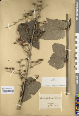
LE 01247508
Scrophularia nodosa L.
Groups of specimens: Образцы сектора Восточной Европы; Соглашение Минобрнауки №075-15-2021-1056Record creation: 2023-09-06, Mariya Sheludyakova, PhotoScan D2.Citation: Specimen LE 01247508 // Virtual herbarium of Komarov Botanical Institute RAS — http://re.herbariumle.ru/01247508