View
Add
Copy
Edit
Delete
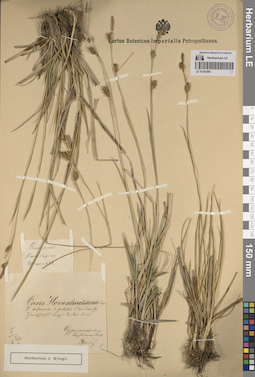
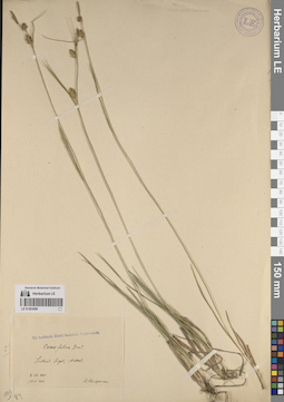
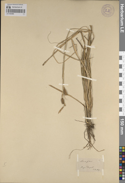
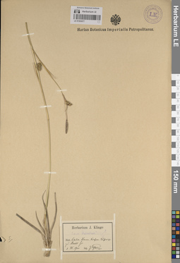
LE 01263101
Groups of specimens: Образцы сектора Восточной Европы; Соглашение Минобрнауки №075-15-2021-1056Record creation: 2023-10-25, Artyom Leostrin, PhotoScan D2.Citation: Specimen LE 01263101 // Virtual herbarium of Komarov Botanical Institute RAS — http://re.herbariumle.ru/01263101
LE 01259236
Echinops spinosissimus Turra det. Byalt, Vyacheslav Vyacheslavovich
Collectors: Byalt, Vyacheslav Vyacheslavovich; Korshunov, Vladimir Mikhailovich Field collecting number: 1202. Collection date: 31.03.2018. Administrative regions: AE - United Arab Emirates. Place of collection: эмират Фуджейра, окрестности пос. Дадна, западный край Вади вурайя национального парка: глубокое ущелье.Groups of specimens: Образцы общего сектора; Соглашение Минобрнауки №075-15-2021-1056; Бялт В.В.: Флора ФуджейрыOriginal label text: United Arab Emirates. Emirate of Fujaira, env. of Dhadna, 25°31'02.2"N 56°17'50.5"E, ca. 200-300 m alt., W edege of Wadi Wurayah national park: in the deep gorge. – ОАЭ, эмират Фуджейра, окр. пос. Дадна, 25°31'02.2"N 56°17'50.5"E, ca. 200-300 м н. ур. м., W край Вади вурайя нац. парка: глубокое ущелье, 31 III 2018, V.V. Byalt, V. Korshunov 1202
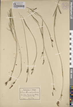
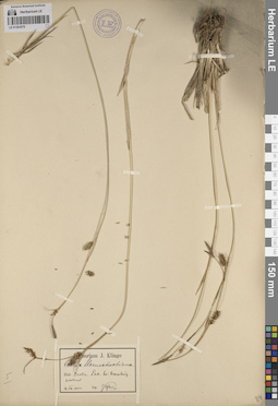
LE 01263100
Groups of specimens: Образцы сектора Восточной Европы; Соглашение Минобрнауки №075-15-2021-1056Record creation: 2023-10-25, Artyom Leostrin, PhotoScan D2.Citation: Specimen LE 01263100 // Virtual herbarium of Komarov Botanical Institute RAS — http://re.herbariumle.ru/01263100

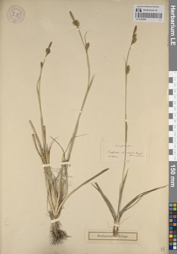
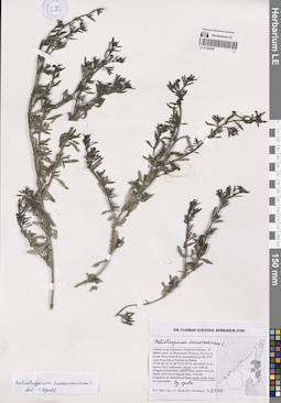
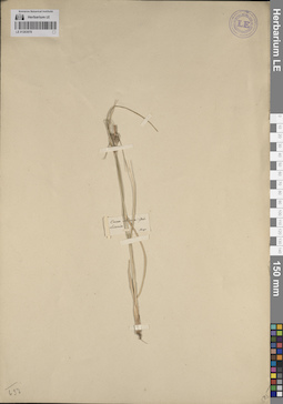
LE 01263099
Groups of specimens: Образцы сектора Восточной Европы; Соглашение Минобрнауки №075-15-2021-1056Record creation: 2023-10-25, Artyom Leostrin, PhotoScan D2.Citation: Specimen LE 01263099 // Virtual herbarium of Komarov Botanical Institute RAS — http://re.herbariumle.ru/01263099
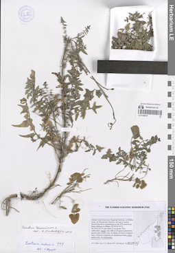
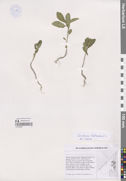
LE 01259235
Lactuca indica L. ⟮prelim. ID⟯ det. Byalt, Vyacheslav Vyacheslavovich
Collectors: Byalt, Vyacheslav Vyacheslavovich; Korshunov, Mikhail Vladimirovich Field collecting number: 3230 (2). Collection date: 15.05.2020. Administrative regions: AE - United Arab Emirates. Place of collection: Fujairah Emirate, Al Dibba town, Al Phoenician Nursery, 0.3 km to South-West from first roundabout on the E99 road from Khor-Fakkan to Dibba [point 791]: weed under palm trees, on sand paths.Groups of specimens: Образцы общего сектора; Соглашение Минобрнауки №075-15-2021-1056; Бялт В.В.: Флора ФуджейрыOriginal label text: United Arab Emirates, Fujairah Emirate, Al Dibba town, Al Phoenician Nursery, 0.3 km to South-West from first roundabout on the E99 road from Khor-Fakkan to Dibba. 25°35'49.78"N, 56°19'22.51"E, elevation 11 m [point 791]: weed under palm trees, on sand paths. 26 V 2020, V.V. Byalt, M.V. Korshunov
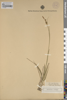
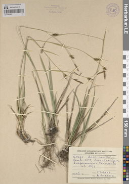
LE 01263095
Groups of specimens: Образцы сектора Восточной Европы; Соглашение Минобрнауки №075-15-2021-1056Record creation: 2023-10-25, Artyom Leostrin, PhotoScan D2.Citation: Specimen LE 01263095 // Virtual herbarium of Komarov Botanical Institute RAS — http://re.herbariumle.ru/01263095
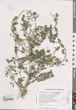
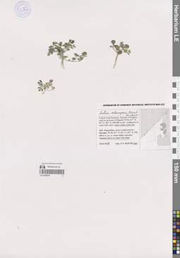
LE 01259234
Chenopodium aff. opulifolium Schoad det. Sukhorukov, Alexander Petrovich at 2023
Collectors: Byalt, Vyacheslav Vyacheslavovich; Korshunov, Mikhail Vladimirovich Field collecting number: s.n. Collection date: 15.05.2020. Administrative regions: AE - United Arab Emirates. Place of collection: Fujairah Emirate, Al Dibba town, Al Phoenician Nursery, 0.3 km to South-West from first roundabout on the E99 road from Khor-Fakkan to Dibba [point 791].Groups of specimens: Образцы общего сектора; Соглашение Минобрнауки №075-15-2021-1056; Бялт В.В.: Флора ФуджейрыOriginal label text: United Arab Emirates, Fujairah Emirate, Al Dibba town, Al Phoenician Nursery, 0.3 km to South-West from first roundabout on the E99 road from Khor-Fakkan to Dibba. 25°35'49.78"N, 56°19'22.51"E, elevation 11 m [point 791]: cultivated / weed / run wild on irrigated plantation, plastic pots, under tree, in shade, between irrigated lines, without irrigation on abandoned land, under palm trees, on sand paths. 26 V 2020, V.V. Byalt, M.V. Korshunov
LE 01263094
Groups of specimens: Образцы сектора Восточной Европы; Соглашение Минобрнауки №075-15-2021-1056Record creation: 2023-10-25, Artyom Leostrin, PhotoScan D2.Citation: Specimen LE 01263094 // Virtual herbarium of Komarov Botanical Institute RAS — http://re.herbariumle.ru/01263094
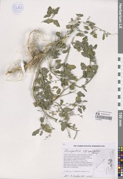
LE 01259233
Chenopodium aff. opulifolium Schoad det. Sukhorukov, Alexander Petrovich at 2023
Collectors: Byalt, Vyacheslav Vyacheslavovich; Korshunov, Mikhail Vladimirovich Field collecting number: s.n. Collection date: 15.05.2020. Administrative regions: AE - United Arab Emirates. Place of collection: Fujairah Emirate, Al Dibba town, Al Phoenician Nursery, 0.3 km to South-West from first roundabout on the E99 road from Khor-Fakkan to Dibba [point 791].Groups of specimens: Образцы общего сектора; Соглашение Минобрнауки №075-15-2021-1056; Бялт В.В.: Флора ФуджейрыOriginal label text: United Arab Emirates, Fujairah Emirate, Al Dibba town, Al Phoenician Nursery, 0.3 km to South-West from first roundabout on the E99 road from Khor-Fakkan to Dibba. 25°35'49.78"N, 56°19'22.51"E, elevation 11 m [point 791]: cultivated / weed / run wild on irrigated plantation, plastic pots, under tree, in shade, between irrigated lines, without irrigation on abandoned land, under palm trees, on sand paths. 26 V 2020, V.V. Byalt, M.V. Korshunov s.n
LE 01263093
Groups of specimens: Образцы сектора Восточной Европы; Соглашение Минобрнауки №075-15-2021-1056Record creation: 2023-10-25, Artyom Leostrin, PhotoScan D2.Citation: Specimen LE 01263093 // Virtual herbarium of Komarov Botanical Institute RAS — http://re.herbariumle.ru/01263093
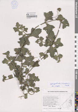
LE 01259232
Sphagneticola trilobata (L.) Pruski det. Byalt, Vyacheslav Vyacheslavovich
Collectors: Byalt, Vyacheslav Vyacheslavovich; Korshunov, Mikhail Vladimirovich Field collecting number: 3244. Collection date: 15.05.2020. Administrative regions: AE - United Arab Emirates. Place of collection: Fujairah Emirate, Al Dibba town, Al Phoenician Nursery, 0.3 km to South-West from first roundabout on the E99 road from Khorfakkan to Dibba [point 791]: cultivated and run wild on irrigated plantation and under palm trees, on sand, big spots.Groups of specimens: Образцы общего сектора; Соглашение Минобрнауки №075-15-2021-1056; Бялт В.В.: Флора ФуджейрыOriginal label text: United Arab Emirates, FE, Al Dibba town, Al Phoenician Nursery, 0.3 km to South-West from first roundabout on the E99 road from Khorfakkan to Dibba. 25°35'49.78"N, 56°19'22.51"E, elevation 11 m [point 791]: cultivated and run wild on irrigated plantation and under palm trees, on sand, big spots, 26 V 2020, fl., fr., V. B., M. K. 3244
LE 01263092
Groups of specimens: Образцы сектора Восточной Европы; Соглашение Минобрнауки №075-15-2021-1056Record creation: 2023-10-25, Artyom Leostrin, PhotoScan D2.Citation: Specimen LE 01263092 // Virtual herbarium of Komarov Botanical Institute RAS — http://re.herbariumle.ru/01263092
LE 01259231
Leucaena leucocephala (Lam.) de Wit det. Byalt, Vyacheslav Vyacheslavovich
Collectors: Byalt, Vyacheslav Vyacheslavovich; Korshunov, Mikhail Vladimirovich Field collecting number: 3246 bis. Collection date: 15.05.2020. Administrative regions: AE - United Arab Emirates. Place of collection: Fujairah Emirate, Al Dibba town, Al Phoenician Nursery, 0.3 km to South-West from first roundabout on the E99 road from Khorfakkan to Dibba [point 791]: weed (run wild) in nursery.Groups of specimens: Образцы общего сектора; Соглашение Минобрнауки №075-15-2021-1056; The Fujairah Scientific Herbarium (FSH); Бялт В.В.: Флора ФуджейрыOriginal label text: United Arab Emirates, Fujairah Emirate, Al Dibba town, Al Phoenician Nursery, 0.3 km to South-West from first roundabout on the E99 road from Khorfakkan to Dibba. 25°35'49.78"N, 56°19'22.51"E, elevation 11 m [point 791]: weed (run wild) in nursery, 26 V 2020, veg., V.V. Byalt, M.V. Korshunov 3246 bis
LE 01263091
Groups of specimens: Образцы сектора Восточной Европы; Соглашение Минобрнауки №075-15-2021-1056Record creation: 2023-10-25, Artyom Leostrin, PhotoScan D2.Citation: Specimen LE 01263091 // Virtual herbarium of Komarov Botanical Institute RAS — http://re.herbariumle.ru/01263091
LE 01259230
Leucaena leucocephala (Lam.) de Wit det. Byalt, Vyacheslav Vyacheslavovich
Collectors: Byalt, Vyacheslav Vyacheslavovich; Korshunov, Mikhail Vladimirovich Field collecting number: 3246. Collection date: 26.05.2020. Administrative regions: AE - United Arab Emirates. Place of collection: Fujairah Emirate, Al Aqah [point 792]: in irrigation circles.Groups of specimens: Образцы общего сектора; Соглашение Минобрнауки №075-15-2021-1056; Бялт В.В.: Флора ФуджейрыOriginal label text: United Arab Emirates, Fujairah Emirate, Al Aqah, 25°30'6.28"N, 56°21'30.01"E, elevation 14 m. [point 792]: in irrigation circles, 26 V 2020, V.V. Byalt, M.V. Korshunov 3246
LE 01263090
Groups of specimens: Образцы сектора Восточной Европы; Соглашение Минобрнауки №075-15-2021-1056Record creation: 2023-10-25, Artyom Leostrin, PhotoScan D2.Citation: Specimen LE 01263090 // Virtual herbarium of Komarov Botanical Institute RAS — http://re.herbariumle.ru/01263090
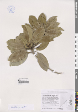
LE 01259229
Manilkara sapota L. det. Byalt, Vyacheslav Vyacheslavovich
Collectors: Byalt, Vyacheslav Vyacheslavovich; Korshunov, Mikhail Vladimirovich Field collecting number: 3242 (2). Collection date: 15.05.2020. Administrative regions: AE - United Arab Emirates. Place of collection: Fujairah Emirate, Al Dibba town, Al Phoenician Nursery, 0.3 km to South-West from first roundabout on the E99 road from Khor-Fakkan to Dibba [point 791]: cultivated.Groups of specimens: Образцы общего сектора; Соглашение Минобрнауки №075-15-2021-1056; Бялт В.В.: Флора ФуджейрыOriginal label text: United Arab Emirates, Fujairah Emirate, Al Dibba town, Al Phoenician Nursery, 0.3 km to South-West from first roundabout on the E99 road from Khor-Fakkan to Dibba. 25°35'49.78"N, 56°19'22.51"E, elevation 11 m [point 791]: cultivated. 26 V 2020, V.V. Byalt, M.V. Korshunov
LE 01263089
Groups of specimens: Образцы сектора Восточной Европы; Соглашение Минобрнауки №075-15-2021-1056Record creation: 2023-10-25, Artyom Leostrin, PhotoScan D2.Citation: Specimen LE 01263089 // Virtual herbarium of Komarov Botanical Institute RAS — http://re.herbariumle.ru/01263089
LE 01263088
Groups of specimens: Образцы сектора Восточной Европы; Соглашение Минобрнауки №075-15-2021-1056Record creation: 2023-10-25, Artyom Leostrin, PhotoScan D2.Citation: Specimen LE 01263088 // Virtual herbarium of Komarov Botanical Institute RAS — http://re.herbariumle.ru/01263088
LE 01259228
Heliotropium curassavicum L. det. Byalt, Vyacheslav Vyacheslavovich
Collectors: Byalt, Vyacheslav Vyacheslavovich; Korshunov, Mikhail Vladimirovich Field collecting number: 3237. Collection date: 15.05.2020. Administrative regions: AE - United Arab Emirates. Place of collection: Fujairah Emirate, Al Dibba town, Al Phoenician Nursery, 0.3 km to South-West from first roundabout on the E99 road from Khor-Fakkan to Dibba [point 791]: weed under palm trees, by spots.Groups of specimens: Образцы общего сектора; Соглашение Минобрнауки №075-15-2021-1056; Бялт В.В.: Флора ФуджейрыOriginal label text: United Arab Emirates, Fujairah Emirate, Al Dibba town, Al Phoenician Nursery, 0.3 km to South-West from first roundabout on the E99 road from Khor-Fakkan to Dibba. 25°35'49.78"N, 56°19'22.51"E, elevation 11 m [point 791]: weed under palm trees, by spots. 15 V 2020, V.V. Byalt, M.V. Korshunov 3237
LE 01263087
Groups of specimens: Образцы сектора Восточной Европы; Соглашение Минобрнауки №075-15-2021-1056Record creation: 2023-10-25, Artyom Leostrin, PhotoScan D2.Citation: Specimen LE 01263087 // Virtual herbarium of Komarov Botanical Institute RAS — http://re.herbariumle.ru/01263087

LE 01259227
Washingtonia filifera (Linden ex Andre) H. Wendl. ex de Bary det. Byalt, Vyacheslav Vyacheslavovich
Collectors: Byalt, Vyacheslav Vyacheslavovich; Korshunov, Mikhail Vladimirovich Field collecting number: 3221(2). Collection date: 15.05.2020. Administrative regions: AE - United Arab Emirates. Place of collection: Fujairah Emirate, Al Dibba town, Al Phoenician Nursery, 0.3 km to South-West from first roundabout on the E99 road from Khorfakkan to Dibba [point 791]: run wild under palm trees of Washingtonia, on sand.Groups of specimens: Образцы общего сектора; Соглашение Минобрнауки №075-15-2021-1056; Бялт В.В.: Флора ФуджейрыOriginal label text: United Arab Emirates, Fujairah Emirate, Al Dibba town, Al Phoenician Nursery, 0.3 km to South-West from first roundabout on the E99 road from Khorfakkan to Dibba. 25° 22′ 30.68′′ N, 56°20′41.51′′ E, elevation 11 m [point 791]: run wild under palm trees of Washingtonia, on sand, 26 V 2020, veg., V.V. Byalt, M.V. Korshunov 3221
LE 01263086
Groups of specimens: Образцы сектора Восточной Европы; Соглашение Минобрнауки №075-15-2021-1056Record creation: 2023-10-25, Artyom Leostrin, PhotoScan D2.Citation: Specimen LE 01263086 // Virtual herbarium of Komarov Botanical Institute RAS — http://re.herbariumle.ru/01263086

LE 01263085
Groups of specimens: Образцы сектора Восточной Европы; Соглашение Минобрнауки №075-15-2021-1056Record creation: 2023-10-25, Artyom Leostrin, PhotoScan D2.Citation: Specimen LE 01263085 // Virtual herbarium of Komarov Botanical Institute RAS — http://re.herbariumle.ru/01263085
LE 01259226
Corchorus trilocularis L. det. Byalt, Vyacheslav Vyacheslavovich
Collectors: Byalt, Vyacheslav Vyacheslavovich; Korshunov, Mikhail Vladimirovich Field collecting number: s.n. Collection date: 28.05.2020. Administrative regions: AE - United Arab Emirates. Place of collection: Fujairah Emirate, vil. Sharm [point 793]: in drainage near wall; in irrigation circles; on the garden fence; under tree; on roadside; at the sewerage pipe outlet; in shady side street between villas; waste place on edge of village; on dry bottom of pond upper the dam.Groups of specimens: Образцы общего сектора; Соглашение Минобрнауки №075-15-2021-1056; Бялт В.В.: Флора ФуджейрыOriginal label text: United Arab Emirates, Fujairah Emirate, vil. Sharm, 25°28'17.54"N, 56°21'8.03"E, elevation 10–45 m [point 793]: in drainage near wall; in irrigation circles; on the garden fence; under tree; on roadside; at the sewerage pipe outlet; in shady side street between villas; waste place on edge of village; on dry bottom of pond upper the dam, 28 V 2020, V.V. Byalt, M.V. Korshunov
LE 01263084
Groups of specimens: Образцы сектора Восточной Европы; Соглашение Минобрнауки №075-15-2021-1056Record creation: 2023-10-25, Artyom Leostrin, PhotoScan D2.Citation: Specimen LE 01263084 // Virtual herbarium of Komarov Botanical Institute RAS — http://re.herbariumle.ru/01263084
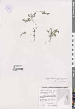
LE 01259225
Argyrolobium roseum (Cambess.) Jaub. & Spach det. Byalt, Vyacheslav Vyacheslavovich at 19.12.2022
Additional identifications: Lotus schimperi Steud. ex Boiss. det. Byalt, Vyacheslav Vyacheslavovich Collectors: Byalt, Vyacheslav Vyacheslavovich Field collecting number: 525. Collection date: 31.03.2017. Administrative regions: AE - United Arab Emirates. Place of collection: Шаржа, глубокое ущелье на границе с Фуджейрой: скалы у ручья.Groups of specimens: Образцы общего сектора; Соглашение Минобрнауки №075-15-2021-1056; Бялт В.В.: Флора ФуджейрыOriginal label text: United Arab Emirates. Emirate of Sharjah, 25°22, 997’ N, 56° 01, 211’ E, 470 m alt., gorge on borders with Fujaira: on rocks near spring.– ОАЭ, Шаржа, 25°22, 997’ N, 56° 01, 211’ E, 470 м выс., глубокое ущелье на границе с Фуджейрой: скалы у ручья, 31 III 2017, fl., fr., V.V. Byalt 525
LE 01263083
Groups of specimens: Образцы сектора Восточной Европы; Соглашение Минобрнауки №075-15-2021-1056Record creation: 2023-10-25, Artyom Leostrin, PhotoScan D2.Citation: Specimen LE 01263083 // Virtual herbarium of Komarov Botanical Institute RAS — http://re.herbariumle.ru/01263083
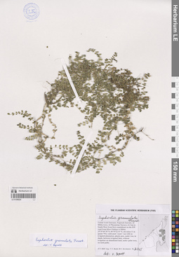
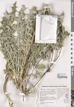
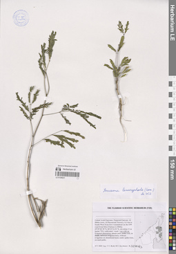
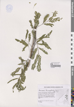
LE 01259224
Euphorbia granulata Forssk. det. Byalt, Vyacheslav Vyacheslavovich
Collectors: Byalt, Vyacheslav Vyacheslavovich; Korshunov, Mikhail Vladimirovich Field collecting number: 3245. Collection date: 15.05.2020. Administrative regions: AE - United Arab Emirates. Place of collection: Fujairah Emirate, Al Dibba town, Al Phoenician Nursery, 0.3 km to South-West from first roundabout on the E99 road from Khorfakkan to Dibba [point 791]: common weed under palm trees, on sand paths.Groups of specimens: Образцы общего сектора; Соглашение Минобрнауки №075-15-2021-1056; Бялт В.В.: Флора ФуджейрыOriginal label text: United Arab Emirates, Fujairah Emirate, Al Dibba town, Al Phoenician Nursery, 0.3 km to South-West from first roundabout on the E99 road from Khorfakkan to Dibba. 25°35'49.78"N, 56°19'22.51"E, elevation 11 m [point 791]: common weed under palm trees, on sand paths, 26 V 2020, fl., fr., V.V. Byalt, M.V. Korshunov 3245
LE 01263082
Groups of specimens: Образцы сектора Восточной Европы; Соглашение Минобрнауки №075-15-2021-1056Record creation: 2023-10-25, Artyom Leostrin, PhotoScan D2.Citation: Specimen LE 01263082 // Virtual herbarium of Komarov Botanical Institute RAS — http://re.herbariumle.ru/01263082

LE 01259223
Medicago laciniata (L.) Mill. det. Byalt, Vyacheslav Vyacheslavovich
Collectors: Byalt, Vyacheslav Vyacheslavovich; Korshunov, Mikhail Vladimirovich Field collecting number: s.n. Collection date: 02.04.2018. Administrative regions: AE - United Arab Emirates. Place of collection: эмират Фуджейра, 2,5 км юго-западнее Дахир, сорное в частном саду.Groups of specimens: Образцы общего сектора; Соглашение Минобрнауки №075-15-2021-1056; Бялт В.В.: Флора ФуджейрыOriginal label text: United Arab Emirates. Emirate of Fujaira, 2,5 km to SW from Dahir, 25°30'28.7"N 56°07'59.8"E, ca. 150 m alt., weed in garden.– ОАЭ, эмират Фуджейра, 2,5 км SW от Дахир, 25°30'0.54"N 56° 7'52.40"E, ca. 150 м н. ур. м., срное в частном саду, 2 IV 2018, fr., fl., V.V. Byalt, M.V. Korshunov s.n.
LE 01263081
Groups of specimens: Образцы сектора Восточной Европы; Соглашение Минобрнауки №075-15-2021-1056Record creation: 2023-10-25, Artyom Leostrin, PhotoScan D2.Citation: Specimen LE 01263081 // Virtual herbarium of Komarov Botanical Institute RAS — http://re.herbariumle.ru/01263081

LE 01259222
Argyrolobium roseum (Cambess.) Jaub. & Spach det. Byalt, Vyacheslav Vyacheslavovich at 19.12.2022
Additional identifications: Lotus schimperi Steud. ex Boiss. det. Byalt, Vyacheslav Vyacheslavovich Collectors: Byalt, Vyacheslav Vyacheslavovich Field collecting number: 79. Collection date: 22.03.2017. Administrative regions: AE - United Arab Emirates. Place of collection: Фуджейра, Вади Вурайа Национальный парк, в 8 км северо-западнее г. Хор Факкан, огороженные загоны для таров в горах: в низине, у входа в загоны.Groups of specimens: Образцы общего сектора; Соглашение Минобрнауки №075-15-2021-1056; Бялт В.В.: Флора ФуджейрыOriginal label text: United Arab Emirates. Emirate of Fujaira, Wadi Wurayah National Park, 8 km NW from Khor Fakkan, ca. 25°23’ N, 56° 18’ E, ca. 160–170 m alt., fenced paddocks for tar in the mountains: in the hollow near entrance. – ОАЭ, Фуджейра, Вади Вурайа Национальный парк, в 8 км к СЗ от г. Хор Факкан, ca. 25°23’ N, 56° 18’ E, огороженные загоны для таров в горах: в низине, у входа в загоны, 22 III 2017, V.V. Byalt
LE 01263080
Groups of specimens: Образцы сектора Восточной Европы; Соглашение Минобрнауки №075-15-2021-1056Record creation: 2023-10-25, Artyom Leostrin, PhotoScan D2.Citation: Specimen LE 01263080 // Virtual herbarium of Komarov Botanical Institute RAS — http://re.herbariumle.ru/01263080
LE 01263079
Groups of specimens: Образцы сектора Восточной Европы; Соглашение Минобрнауки №075-15-2021-1056Record creation: 2023-10-25, Artyom Leostrin, PhotoScan D2.Citation: Specimen LE 01263079 // Virtual herbarium of Komarov Botanical Institute RAS — http://re.herbariumle.ru/01263079
LE 01263078
Groups of specimens: Образцы сектора Восточной Европы; Соглашение Минобрнауки №075-15-2021-1056Record creation: 2023-10-25, Artyom Leostrin, PhotoScan D2.Citation: Specimen LE 01263078 // Virtual herbarium of Komarov Botanical Institute RAS — http://re.herbariumle.ru/01263078
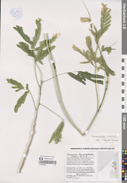
LE 01259221
Sesbania sesban (L.) Merr. det. Byalt, Vyacheslav Vyacheslavovich at 12.2022
Additional identifications: Sesbania hederacea (Mill.) McVaugh det. Byalt, Vyacheslav Vyacheslavovich Collectors: Byalt, Vyacheslav Vyacheslavovich; Korshunov, Mikhail Vladimirovich Field collecting number: 1577/302. Collection date: 24.11.2019. Administrative regions: AE - United Arab Emirates. Place of collection: Фуджейра, Аль Тайба в окрестности г. Фуджейра, поливные места в южной части фермы шейха Хамада II [точка 342]; сорное на пальмовой аллее.Groups of specimens: Образцы общего сектора; Соглашение Минобрнауки №075-15-2021-1056; Бялт В.В.: Флора ФуджейрыOriginal label text: United Arab Emirates. Emirate of Fujaira, Al Taiba in environs of the city of Al Fujeira, 25°09'29.6"N 56°17'31"E: in irrigated places in S part of farm of the Sheikh Khamad II [point 342], weed on date palm alley, big specimen up to 2 m h. – ОАЭ, Фуджейра, Аль Тайба в окр. г. Фуджейра, 25°09'29.6"N 56°17'31"E: в поливных местах в S части фермы шейха Хамада II [точка 342]; сорняк на пальмовой аллее. 24 XI 2019, fl., fr., V.V. Byalt & M.V. Korshunov 1577/302
LE 01263077
Groups of specimens: Образцы сектора Восточной Европы; Соглашение Минобрнауки №075-15-2021-1056Record creation: 2023-10-25, Artyom Leostrin, PhotoScan D2.Citation: Specimen LE 01263077 // Virtual herbarium of Komarov Botanical Institute RAS — http://re.herbariumle.ru/01263077
LE 01259220
Tamarindus indica L. det. Byalt, Vyacheslav Vyacheslavovich at 25.10.2023
Additional identifications: Leucaena leucocephala (Lam.) de Wit det. Byalt, Vyacheslav Vyacheslavovich Collectors: Byalt, Vyacheslav Vyacheslavovich; Korshunov, Mikhail Vladimirovich Field collecting number: 1575/306. Collection date: 24.11.2019. Administrative regions: AE - United Arab Emirates. Place of collection: Фуджейра, Аль Тайба в окрестности г. Фуджейра [точка 342]: сорное в поливных кругах в северной части фермы шейха Хамада II.Groups of specimens: Образцы общего сектора; Соглашение Минобрнауки №075-15-2021-1056; Бялт В.В.: Флора ФуджейрыOriginal label text: United Arab Emirates. Emirate of Fujaira, Al Taiba in environs of the city of Al Fujeira, 25°09'29.6"N 56°17'31"E [point 342]: weed (seedlings), in irrigated places in N part of farm of the Sheikh Khamad II. – ОАЭ, Фуджейра, Аль Тайба в окр. г. Фуджейра, 25°09'29.6"N 56°17'31"E, [точка 342]: сорняк в поливных кругах в N части фермы шейха Хамада II, 24 XI 2019, veg., V.V. Byalt & M.V. Korshunov 1575/306
LE 01263076
Groups of specimens: Образцы сектора Восточной Европы; Соглашение Минобрнауки №075-15-2021-1056Record creation: 2023-10-25, Artyom Leostrin, PhotoScan D2.Citation: Specimen LE 01263076 // Virtual herbarium of Komarov Botanical Institute RAS — http://re.herbariumle.ru/01263076
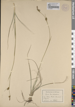
LE 01259218
Lotus schimperi Steud. ex Boiss. det. Byalt, Vyacheslav Vyacheslavovich
Collectors: Byalt, Vyacheslav Vyacheslavovich Field collecting number: 430. Collection date: 29.03.2017. Administrative regions: AE - United Arab Emirates. Place of collection: Фуджейра, вади в окрестности г. Мазафи, плоские места по краю над вади.Groups of specimens: Образцы общего сектора; Соглашение Минобрнауки №075-15-2021-1056; Бялт В.В.: Флора ФуджейрыOriginal label text: United Arab Emirates. Emirate of Fujaira, wadi in environs of Masafi, 25°20, 017’ N, 56° 11, 847’ E, 540–600 m alt.: plane under wadi side.– ОАЭ, Фуджейра, вади в окрестности г. Мазафи, 25°20, 017’ N, 56° 11, 847’ E, 540–600 м н. ур. м.: плоские места по краю над вади, 29 III 2017, fl., V.V. Byalt 430
LE 01263075
Groups of specimens: Образцы сектора Восточной Европы; Соглашение Минобрнауки №075-15-2021-1056Record creation: 2023-10-25, Artyom Leostrin, PhotoScan D2.Citation: Specimen LE 01263075 // Virtual herbarium of Komarov Botanical Institute RAS — http://re.herbariumle.ru/01263075
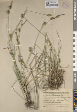
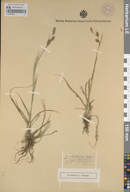
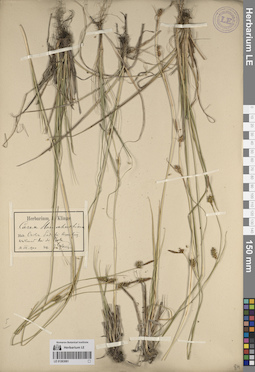
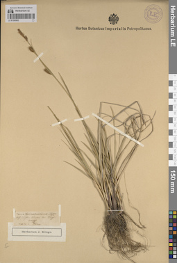
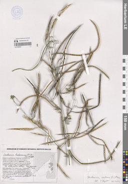
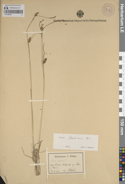
LE 01259217
Enneapogon desvauxii Beauv. det. Byalt, Vyacheslav Vyacheslavovich
Collectors: Byalt, Vyacheslav Vyacheslavovich; Korshunov, Mikhail Vladimirovich Field collecting number: 1514/192. Collection date: 23.11.2019. Administrative regions: AE - United Arab Emirates. Place of collection: Фуджейра, горы Хаджар. Граница эмиратов Фуджейра и Рас-эль-Хайма, старая дорога Масафи-Дибба, вади: на дне.Groups of specimens: Образцы общего сектора; Соглашение Минобрнауки №075-15-2021-1056; Бялт В.В.: Флора ФуджейрыOriginal label text: United Arab Emirates. Mts. Hajar. Border of emirate of Fujaira and Ras al Khaima, old road Masafi-Dibba, 25°21'17.57"N 56°10'47.12"E, ca. 515 m alt.: on wadi bottom.– ОАЭ, Фуджейра, горы Хаджар. Граница эмиратов Фуджейра и Рас-эль-Хайма, старая дорога Масафи-Дибба, 25 ° 21'17.57 "N 56 ° 10'47.12" E, ок. 515 м. Вади: на дне, 23 XI 2019, fl., V.V. Byalt, M.V. Korshunov 1514/192
LE 01263074
Groups of specimens: Образцы сектора Восточной Европы; Соглашение Минобрнауки №075-15-2021-1056Record creation: 2023-10-25, Artyom Leostrin, PhotoScan D2.Citation: Specimen LE 01263074 // Virtual herbarium of Komarov Botanical Institute RAS — http://re.herbariumle.ru/01263074

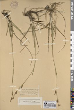
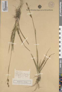
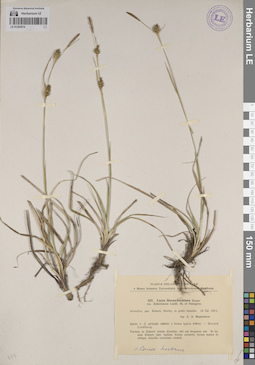
LE 01259216
Eriochloa fatmensis (Hochst. & Steud.) Clayton det. Byalt, Vyacheslav Vyacheslavovich
Additional identifications: Eriochloa batmensis (Hochst. & Steud.) W.D.Clayton det. Byalt, Vyacheslav Vyacheslavovich Collectors: Byalt, Vyacheslav Vyacheslavovich; Korshunov, Mikhail Vladimirovich Field collecting number: 1365/26. Collection date: 21.11.2019. Administrative regions: AE - United Arab Emirates. Place of collection: Фуджейра, г. Дибба, сады в юго-восточной части города и прилегающие улочки: сорное вдоль ограды сада.Groups of specimens: Образцы общего сектора; Соглашение Минобрнауки №075-15-2021-1056; Бялт В.В.: Флора ФуджейрыOriginal label text: United Arab Emirates. Emirate of Fujaira, Dibba, 25°36'46.39"N 56°16'07.85"E, 10 m alt., gardens in SE part and adjacent streets: weed along the fence of the garden. – ОАЭ, Фуджейра, Дибба, 25°36'46.39"N 56°16'07.85"E, 10 м н.ур.м., сады в юго-восточной части города и прилегающие улочки: сорняк вдоль ограды сада, 21 XI 2019, fl., V.V. Byalt, M.V. Korshunov 1365/26
LE 01263073
Groups of specimens: Образцы сектора Восточной Европы; Соглашение Минобрнауки №075-15-2021-1056Record creation: 2023-10-25, Artyom Leostrin, PhotoScan D2.Citation: Specimen LE 01263073 // Virtual herbarium of Komarov Botanical Institute RAS — http://re.herbariumle.ru/01263073
LE 01263072
Groups of specimens: Образцы сектора Восточной Европы; Соглашение Минобрнауки №075-15-2021-1056Record creation: 2023-10-25, Artyom Leostrin, PhotoScan D2.Citation: Specimen LE 01263072 // Virtual herbarium of Komarov Botanical Institute RAS — http://re.herbariumle.ru/01263072
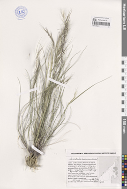
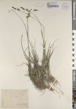
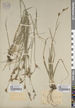
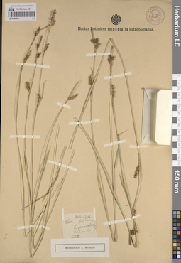
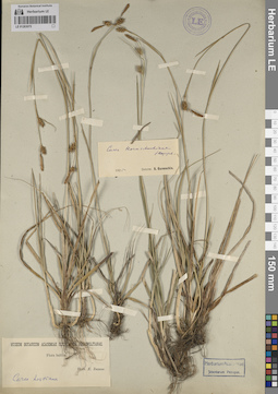
LE 01259215
Aristida adscensionis L. det. Byalt, Vyacheslav Vyacheslavovich
Collectors: Byalt, Vyacheslav Vyacheslavovich; Korshunov, Mikhail Vladimirovich Field collecting number: 1890/651. Collection date: 29.11.2019. Administrative regions: AE - United Arab Emirates. Place of collection: эмират Рас аль Хайма, горы Хаджар, дорога Граграх-Гхуб, обочина шоссе над вади.Groups of specimens: Образцы общего сектора; Соглашение Минобрнауки №075-15-2021-1056; Бялт В.В.: Флора ФуджейрыOriginal label text: United Arab Emirates. Emirate of Ras-al-Khaima, Mts. Hajar, Gragrah-Ghub Road, 25°29'29.35"N 56°03'18.66" E, 159 m alt.:, on roadside of highway, by wadi side.– ОАЭ, эмират Рас аль Хайма, горы Хаджар, дорога Граграх-Гхуб, 25°29'29.35"N 56°03'18.66"E, 159 м н.ур.м.: обочина шоссе над вади, 29 XI 2019, fl., V.V. Byalt & M.V. Korshunov 1890/651
LE 01263071
Groups of specimens: Образцы сектора Восточной Европы; Соглашение Минобрнауки №075-15-2021-1056Record creation: 2023-10-25, Artyom Leostrin, PhotoScan D2.Citation: Specimen LE 01263071 // Virtual herbarium of Komarov Botanical Institute RAS — http://re.herbariumle.ru/01263071

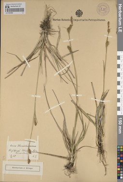
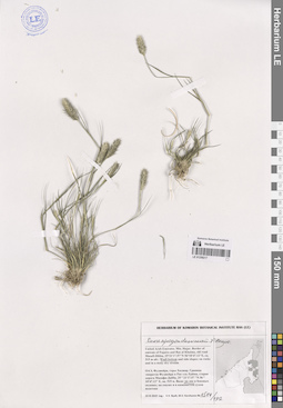
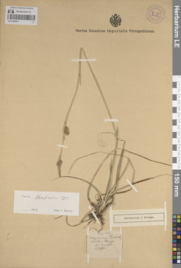
LE 01259214
Aristida adscensionis L. det. Byalt, Vyacheslav Vyacheslavovich
Collectors: Byalt, Vyacheslav Vyacheslavovich; Korshunov, Mikhail Vladimirovich Field collecting number: 1541/184. Collection date: 23.11.2019. Administrative regions: AE - United Arab Emirates. Place of collection: Фуджейра, горы Хаджар. Граница эмиратов Фуджейра и Рас-эль-Хайма, старая дорога Масафи-Дибба, вади: на дне и боковых склонах.Groups of specimens: Образцы общего сектора; Соглашение Минобрнауки №075-15-2021-1056; Бялт В.В.: Флора ФуджейрыOriginal label text: United Arab Emirates. Mts. Hajar. Border of emirate of Fujaira and Ras al Khaima, old road Masafi-Dibba, 25°21'17.57"N 56°10'47.12"E, ca. 515 m alt.: on wadi bottom and side slopes.– ОАЭ, Фуджейра, горы Хаджар. Граница эмиратов Фуджейра и Рас-эль-Хайма, старая дорога Масафи-Дибба, 25 ° 21'17.57 "N 56 ° 10'47.12" E, ок. 515 м. Вади: на дне и боковых склонах, 23 XI 2019, V.V. Byalt, M.V. Korshunov 1541/184