View
Add
Copy
Edit
Delete
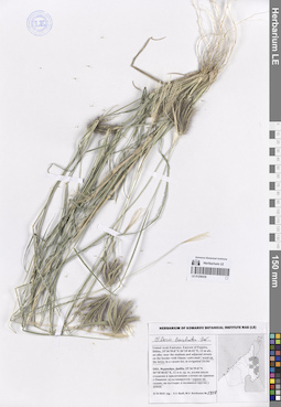
LE 01259446
Pennisetum purpureum Schumach. det. Byalt, Vyacheslav Vyacheslavovich
Additional identifications: Pennisetum glaucum (L.) R. Br. det. Byalt, Vyacheslav Vyacheslavovich Collectors: Byalt, Vyacheslav Vyacheslavovich; Korshunov, Mikhail Vladimirovich Field collecting number: 1488. Collection date: 23.11.2019. Administrative regions: AE - United Arab Emirates. Place of collection: Фуджейра, горы Хаджар. Старая дорога Масафи-Дибба, сады в северо-западной окрестности пос. Аль Хала, культивируется в частном саду Абдулы.Groups of specimens: Образцы общего сектора; Соглашение Минобрнауки №075-15-2021-1056; Бялт В.В.: Флора ФуджейрыOriginal label text: United Arab Emirates. Mts. Hajar. Old road Masafi-Dibba, gardens in NW environs of vil. Al Khala, 25°29'02.84"N 56°11'22"E, ca. 180 m alt.: cultivated in the private garden of Abdulah.– ОАЭ, Фуджейра, горы Хаджар. Старая дорога Масафи-Дибба, сады в сев.-зап. окр. пос. Аль Хала, 25 ° 29'02.84 "N 56 ° 11'22" E, ок. 180 м н. ур. м.: культивируется в частном саду Абдулы, 23 XI 2019, fl., fr., V.V. Byalt, M.V. Korshunov 1488
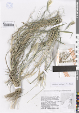
LE 01259445
Chloris barbata Sw. det. Byalt, Vyacheslav Vyacheslavovich
Collectors: Byalt, Vyacheslav Vyacheslavovich; Korshunov, Mikhail Vladimirovich Field collecting number: 1770/462. Collection date: 27.11.2019. Administrative regions: AE - United Arab Emirates. Place of collection: Фуджейра, морская набережная г. Фуджейра [точка 346]: сорное в поливных кругах между полосами шоссе.Groups of specimens: Образцы общего сектора; Соглашение Минобрнауки №075-15-2021-1056; Бялт В.В.: Флора ФуджейрыOriginal label text: United Arab Emirates. Emirate of Fujaira, seafront of the city of Al Fujeira, 25°06'38.35"N 56°21'27.04"E [point 346]: weed in irrigated circles between highway lanes; weed in roundabout at the beginning of the seefront. – ОАЭ, Фуджейра, морская набережная г. Фуджейра, 25°06'38.35"N 56°21'27.04"E [точка 346]: сорняк в поливных кругах между полосами шоссе, 27 XI 2019, fr., V.V. Byalt & M.V. Korshunov 1770/462
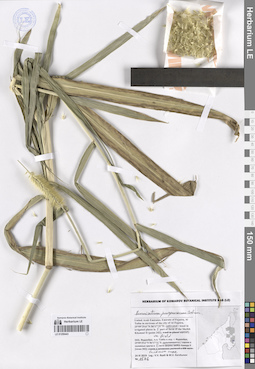
LE 01259444
Pennisetum purpureum Schumach. det. Byalt, Vyacheslav Vyacheslavovich
Additional identifications: Pennisetum glaucum (L.) R. Br. det. Byalt, Vyacheslav Vyacheslavovich Collectors: Byalt, Vyacheslav Vyacheslavovich; Korshunov, Mikhail Vladimirovich Field collecting number: 1488. Collection date: 23.11.2019. Administrative regions: AE - United Arab Emirates. Place of collection: Фуджейра, горы Хаджар. Старая дорога Масафи-Дибба, сады в северо-западной окрестности пос. Аль Хала, культивируется в частном саду Абдулы.Groups of specimens: Образцы общего сектора; Соглашение Минобрнауки №075-15-2021-1056; Бялт В.В.: Флора ФуджейрыOriginal label text: United Arab Emirates. Mts. Hajar. Old road Masafi-Dibba, gardens in NW environs of vil. Al Khala, 25°29'02.84"N 56°11'22"E, ca. 180 m alt.: cultivated in the private garden of Abdulah.– ОАЭ, Фуджейра, горы Хаджар. Старая дорога Масафи-Дибба, сады в сев.-зап. окр. пос. Аль Хала, 25 ° 29'02.84 "N 56 ° 11'22" E, ок. 180 м н. ур. м.: культивируется в частном саду Абдулы, 23 XI 2019, fl., fr., V.V. Byalt, M.V. Korshunov 1488
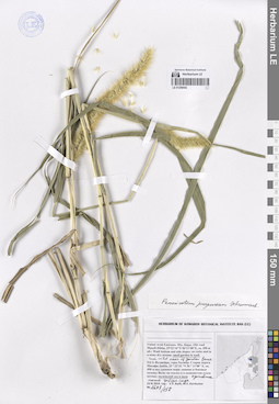
LE 01259443
Pennisetum purpureum Schumach. det. Byalt, Vyacheslav Vyacheslavovich
Collectors: Byalt, Vyacheslav Vyacheslavovich; Korshunov, Mikhail Vladimirovich Field collecting number: 1576. Collection date: 24.11.2019. Administrative regions: AE - United Arab Emirates. Place of collection: Фуджейра, Аль Тайба в окрестности г. Фуджейра [точка 342]: культивируется в поливных кругах в восточной части фермы шейха Хамада II, большое поле.Groups of specimens: Образцы общего сектора; Соглашение Минобрнауки №075-15-2021-1056; Бялт В.В.: Флора ФуджейрыOriginal label text: United Arab Emirates. Emirate of Fujaira, Al Taiba in environs of the city of Al Fujeira, 25°09'29.6"N 56°17'31"E [point 342]: cultivated in irrigated places in E part of farm of the Sheikh Khamad II weed in plant nurcery, on field. – ОАЭ, Фуджейра, Аль Тайба в окр. г. Фуджейра, 25°09'29.6"N 56°17'31"E, [точка 342]: культивируется в поливных кругах в E части фермы шейха Хамада II, большое поле, 24 XI 2019 V.V. Byalt & M.V. Korshunov 1576
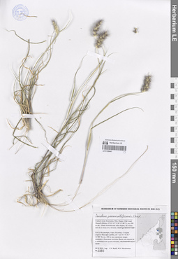
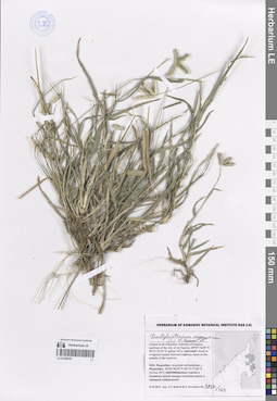
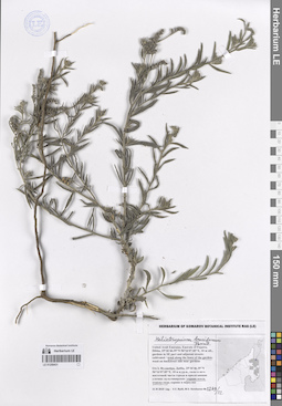
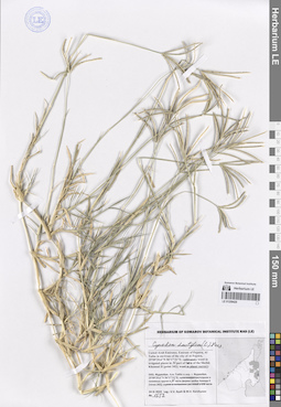
LE 01259442
Pennisetum purpureum Schumach. det. Byalt, Vyacheslav Vyacheslavovich
Collectors: Byalt, Vyacheslav Vyacheslavovich; Korshunov, Mikhail Vladimirovich Field collecting number: 1698/156. Collection date: 23.11.2019. Administrative regions: AE - United Arab Emirates. Place of collection: Фуджейра, горы Хаджар. Старая дорога Масафи-Дибба, одичавшее ниже забора маленького сада в вади.Groups of specimens: Образцы общего сектора; Соглашение Минобрнауки №075-15-2021-1056; Бялт В.В.: Флора ФуджейрыOriginal label text: United Arab Emirates. Mts. Hajar. Old road Masafi-Dibba, 25°22'10"N 56°11'08"E, ca. 490 m alt.: run wild on wadi bottom near fence of small garden. – ОАЭ, Фуджейра, горы Хаджар. Старая дорога Масафи-Дибба, 25 ° 22'10 "N 56 ° 11'08" E, ок. 490 м над уровнем моря: одичавшее ниже забора маленького сада в вади, 23 XI 2019, fl., V.V. Byalt, M.V. Korshunov 1698/156
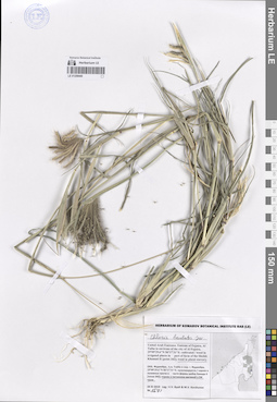
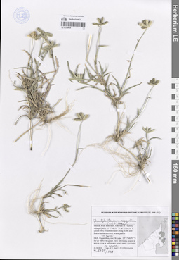
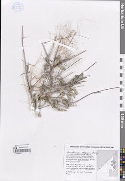
LE 01259441
Cenchrus pennisetiformis Steud. det. Byalt, Vyacheslav Vyacheslavovich
Collectors: Byalt, Vyacheslav Vyacheslavovich; Korshunov, Mikhail Vladimirovich Field collecting number: 1696. Collection date: 23.11.2019. Administrative regions: AE - United Arab Emirates. Place of collection: Фуджейра, горы Хаджар. Старая дорога Масафи-Дибба, нижние и боковые склоны вади; скалы и каменистый сухой поток.Groups of specimens: Образцы общего сектора; Соглашение Минобрнауки №075-15-2021-1056; Бялт В.В.: Флора ФуджейрыOriginal label text: United Arab Emirates. Mts. Hajar. Old road Masafi-Dibba, 25°22'10"N 56°11'08"E, ca. 490 m alt.: on wadi bottom and side slopes; on rocks and in a stony dry stream. – ОАЭ, Фуджейра, горы Хаджар. Старая дорога Масафи-Дибба, 25 ° 22'10 "N 56 ° 11'08" E, ок. 490 м над уровнем моря: нижние и боковые склоны вади; на скалах и в каменистом сухом потоке, 23 XI 2019, V.V. Byalt, M.V. Korshunov 1696
LE 01259440
Chloris barbata Sw. det. Byalt, Vyacheslav Vyacheslavovich
Collectors: Byalt, Vyacheslav Vyacheslavovich; Korshunov, Mikhail Vladimirovich Field collecting number: 1571. Collection date: 24.11.2019. Administrative regions: AE - United Arab Emirates. Place of collection: Фуджейра, Аль Тайба в окрестности г. Фуджейра [точка 342]: сорное в питомнике растений в юго-восточной части.Groups of specimens: Образцы общего сектора; Соглашение Минобрнауки №075-15-2021-1056; Бялт В.В.: Флора ФуджейрыOriginal label text: United Arab Emirates. Emirate of Fujaira, Al Taiba in environs of the city of Al Fujeira, 25°09'29.6"N 56°17'31"E [point 342]: weed in plant nurcery. – ОАЭ, Фуджейра, Аль Тайба в окр. г. Фуджейра, 25°09'29.6"N 56°17'31"E, [точка 342]: сорняк в питомнике растений в ЮВ части, 24 XI 2019 V.V. Byalt & M.V. Korshunov 1571
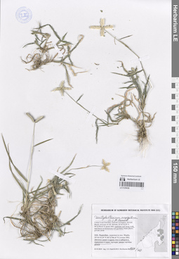
LE 01259439
Chloris barbata Sw. det. Byalt, Vyacheslav Vyacheslavovich
Collectors: Byalt, Vyacheslav Vyacheslavovich; Korshunov, Mikhail Vladimirovich Field collecting number: 1408. Collection date: 21.11.2019. Administrative regions: AE - United Arab Emirates. Place of collection: Фуджейра, г. Дибба, аллея около стадиона и прилегающие улочки на границе с Оманом: сорное на газоне.Groups of specimens: Образцы общего сектора; Соглашение Минобрнауки №075-15-2021-1056; Бялт В.В.: Флора ФуджейрыOriginal label text: United Arab Emirates. Emirate of Fujaira, Dibba, 25°36'59.8"N 56°18'40.02"E, 12 m alt., an alley near the stadium and adjacent streets on the border with Oman: weed on the lawn. – ОАЭ, Фуджейра, Дибба, 25°36'59.8"N 56°18'40.02"E, 12 м н. ур. м., аллея около стадиона и прилегающие улочки на границе с Оманом: сорное на газоне, 21 XI 2019 V.V. Byalt, M.V. Korshunov
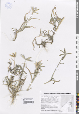
LE 01259438
Chloris quinquesetica Bhide det. Byalt, Vyacheslav Vyacheslavovich
Collectors: Byalt, Vyacheslav Vyacheslavovich; Korshunov, Mikhail Vladimirovich Field collecting number: 1364. Collection date: 21.11.2019. Administrative regions: AE - United Arab Emirates. Place of collection: Фуджейра, г. Дибба, сады в юго-восточной части города и прилегающие улочки: сорное на цветнике с Pennisetum.Groups of specimens: Образцы общего сектора; Соглашение Минобрнауки №075-15-2021-1056; Бялт В.В.: Флора ФуджейрыOriginal label text: United Arab Emirates. Emirate of Fujaira, Dibba, 25°36'46.39"N 56°16'07.85"E, 10 m alt., gardens in SE part and adjacent streets: weed in flower bed with Pennisetum. – ОАЭ, Фуджейра, Дибба, 25°36'46.39"N 56°16'07.85"E, 10 м н.ур.м., сады в юго-восточной части города и прилегающие улочки: сорняк на цветнике с Pennisetum, 21 XI 2019 V.V. Byalt, M.V. Korshunov 1364
LE 01259437
Dactyloctenium aegyptium (L.) P. Beauv. det. Byalt, Vyacheslav Vyacheslavovich
Collectors: Byalt, Vyacheslav Vyacheslavovich; Korshunov, Mikhail Vladimirovich Field collecting number: 1751/461. Collection date: 27.11.2019. Administrative regions: AE - United Arab Emirates. Place of collection: Фуджейра, морская набережная г. Фуджейра [точка 346]: сорное в поливных кругах между полосами шоссе.Groups of specimens: Образцы общего сектора; Соглашение Минобрнауки №075-15-2021-1056; Бялт В.В.: Флора ФуджейрыOriginal label text: United Arab Emirates. Emirate of Fujaira, seafront of the city of Al Fujeira, 25°06'38.35"N 56°21'27.04"E [point 346]: weed in irrigated circles between highway lanes; weed in roundabout at the beginning of the seefront. – ОАЭ, Фуджейра, морская набережная г. Фуджейра, 25°06'38.35"N 56°21'27.04"E [точка 346]: сорняк в поливных кругах между полосами шоссе, 27 XI 2019, fr., V.V. Byalt & M.V. Korshunov 1751/461
LE 01259436
Dactyloctenium aegyptium (L.) P. Beauv. det. Byalt, Vyacheslav Vyacheslavovich
Collectors: Byalt, Vyacheslav Vyacheslavovich; Korshunov, Mikhail Vladimirovich Field collecting number: 1664/408. Collection date: 25.11.2019. Administrative regions: AE - United Arab Emirates. Place of collection: Фуджейра, окрестности пос. Мерба [точка 345]: обочины дорог и вдоль заборов садов.Groups of specimens: Образцы общего сектора; Соглашение Минобрнауки №075-15-2021-1056; Бялт В.В.: Флора ФуджейрыOriginal label text: United Arab Emirates. Emirate of Fujaira, Mirbah Beach, environs of vill. Mirbah, 25°16'15.29"N 56°22'06.41"E [point 345]: roadsides and along fences of gardens. – ОАЭ, Фуджейра, окресности пос. Мерба, 25°16'15.29"N 56°22'06.41"E [точка 345]: обочины дорог и вдоль заборов садов, 25 XI 2019, fl., fr., V.V. Byalt & M.V. Korshunov 1664/408
LE 01259435
Dactyloctenium aegyptium (L.) P. Beauv. det. Byalt, Vyacheslav Vyacheslavovich
Collectors: Byalt, Vyacheslav Vyacheslavovich; Korshunov, Mikhail Vladimirovich Field collecting number: 1832/469. Collection date: 27.11.2019. Administrative regions: AE - United Arab Emirates. Place of collection: Фуджейра, морская набережная г. Фуджейра [точка 347]: сорное в поливных кругах между полосами шоссе в середине набережной.Groups of specimens: Образцы общего сектора; Соглашение Минобрнауки №075-15-2021-1056; Бялт В.В.: Флора ФуджейрыOriginal label text: United Arab Emirates. Emirate of Fujaira, seafront of the city of Al Fujeira, 25°07'18.09"N 56°21'22.92"E [point 347]: weed in irrigated rounds between highway lanes at the middle of the seefront. – ОАЭ, Фуджейра, морская набережная г. Фуджейра, 25°06'38.35"N 56°21'27.04"E [точка 347]: сорняк в поливных кругах между полосами шоссе в середине набережной, 27 XI 2019, fl., fr., V.V. Byalt & M.V. Korshunov 1832/469
LE 01259434
Dactyloctenium aegyptium (L.) P. Beauv. det. Byalt, Vyacheslav Vyacheslavovich
Collectors: Byalt, Vyacheslav Vyacheslavovich; Korshunov, Mikhail Vladimirovich Field collecting number: 1739/383. Collection date: 25.11.2019. Administrative regions: AE - United Arab Emirates. Place of collection: Фуджейра, пос. Кидфа [point 343]: сорное на газоне.Groups of specimens: Образцы общего сектора; Соглашение Минобрнауки №075-15-2021-1056; Бялт В.В.: Флора ФуджейрыOriginal label text: United Arab Emirates. Emirate of Fujaira, village Qidfa, 25°17'40.91"N 56°21'28.51"E [point 343]: on the lawn. – ОАЭ, Фуджейра, пос. Кидфа, 25°17'40.91"N 56°21'28.51"E [point 343]: сорное на газоне, 25 XI 2019, fl., fr., V.V. Byalt & M.V. Korshunov 1731/380, 1739/383
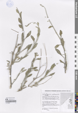
LE 01259433
Heliotropium bacciferum Forssk. det. Byalt, Vyacheslav Vyacheslavovich
Collectors: Byalt, Vyacheslav Vyacheslavovich; Korshunov, Mikhail Vladimirovich Field collecting number: 1366/22a. Collection date: 21.11.2019. Administrative regions: AE - United Arab Emirates. Place of collection: Фуджейра, г. Дибба, сады в юго-восточной части города и прилегающие улочки: сорное вдоль ограды сада.Groups of specimens: Образцы общего сектора; Соглашение Минобрнауки №075-15-2021-1056; Бялт В.В.: Флора ФуджейрыOriginal label text: United Arab Emirates. Emirate of Fujaira, Dibba, 25°36'46.39"N 56°16'07.85"E, 10 m alt., gardens in SE part and adjacent streets: weed along the fence of the garden. – ОАЭ, Фуджейра, Дибба, 25°36'46.39"N 56°16'07.85"E, 10 м н.ур.м., сады в юго-восточной части города и прилегающие улочки: сорняк вдоль ограды сада, 21 XI 2019, fl., fr., V.V. Byalt, M.V. Korshunov 1366/22a
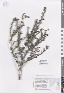
LE 01259432
Heliotropium calcareum Stocks det. Byalt, Vyacheslav Vyacheslavovich
Collectors: Byalt, Vyacheslav Vyacheslavovich; Korshunov, Mikhail Vladimirovich Field collecting number: 1714/121. Collection date: 23.11.2019. Administrative regions: AE - United Arab Emirates. Place of collection: Фуджейра, горы Хаджар. Граница эмиратов Фуджейра и Рас-эль-Хайма, старая дорога Масафи-Дибба, дно и боковые склоны вади.Groups of specimens: Образцы общего сектора; Соглашение Минобрнауки №075-15-2021-1056; Бялт В.В.: Флора ФуджейрыOriginal label text: United Arab Emirates. Mts. Hajar. Border of emirate of Fujaira and Ras al Khaima, old road Masafi-Dibba, 25°21'17.57"N 56°10'47.12"E, ca. 515 m alt.: on wadi bottom and side slopes; on rocks and in a stony dry stream.– ОАЭ, Фуджейра, горы Хаджар. Граница эмиратов Фуджейра и Рас-эль-Хайма, старая дорога Масафи-Дибба, 25 ° 21'17.57 "N 56 ° 10'47.12" E, ок. 515 м.: на дне и боковых склонах вади, 23 XI 2019, fl., V.V. Byalt, M.V. Korshunov 1714/121
LE 01259431
Heliotropium bacciferum Forssk. det. Byalt, Vyacheslav Vyacheslavovich
Collectors: Byalt, Vyacheslav Vyacheslavovich; Korshunov, Mikhail Vladimirovich Field collecting number: 1369/22. Collection date: 21.11.2019. Administrative regions: AE - United Arab Emirates. Place of collection: Фуджейра, г. Дибба, сады в юго-восточной части города и прилегающие улочки: сорное вдоль ограды сада.Groups of specimens: Образцы общего сектора; Соглашение Минобрнауки №075-15-2021-1056; Бялт В.В.: Флора ФуджейрыOriginal label text: United Arab Emirates. Emirate of Fujaira, Dibba, 25°36'46.39"N 56°16'07.85"E, 10 m alt., gardens in SE part and adjacent streets: weed along the fence of the garden. – ОАЭ, Фуджейра, Дибба, 25°36'46.39"N 56°16'07.85"E, 10 м н.ур.м., сады в юго-восточной части города и прилегающие улочки: сорняк вдоль ограды сада, 21 XI 2019 V.V. Byalt, M.V. Korshunov 1369/22
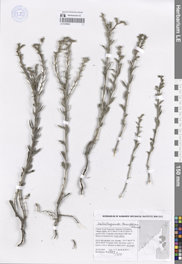
LE 01259430
Boerhavia elegans Choisy det. Byalt, Vyacheslav Vyacheslavovich
Additional identifications: Boerhavia rubicunda Steud. det. Byalt, Vyacheslav Vyacheslavovich Collectors: Byalt, Vyacheslav Vyacheslavovich; Korshunov, Vladimir Mikhailovich Field collecting number: s.n. Collection date: 31.03.2018. Administrative regions: AE - United Arab Emirates. Place of collection: эмират Фуджейра, окрестности пос. Дадна, каменистое ущелье, между валунов.Groups of specimens: Образцы общего сектора; Соглашение Минобрнауки №075-15-2021-1056; Бялт В.В.: Флора ФуджейрыOriginal label text: United Arab Emirates. Emirate of Fujaira, env. of Dhadna, 25°31'02.2"N 56°17'50.2"E, ca. 150–200 m alt.: in the deep gorge, between stones. – ОАЭ, эмират Фуджейра, окр. пос. Дадна, 25°31'02.2"N 56°17'50.2"E, ca. 150–200 м н. ур. м.: каменистое ущелье, между валунов, 31 III 2018, V.V. Byalt, V.M. Korshunov s.n.
LE 01259429
Cynodon dactylon (L.) Pers. det. Byalt, Vyacheslav Vyacheslavovich
Collectors: Byalt, Vyacheslav Vyacheslavovich; Korshunov, Mikhail Vladimirovich Field collecting number: 1833/459. Collection date: 27.11.2019. Administrative regions: AE - United Arab Emirates. Place of collection: Фуджейра, морская набережная г. Фуджейра [точка 347]: сорное в поливных кругах между полосами шоссе в середине набережной.Groups of specimens: Образцы общего сектора; Соглашение Минобрнауки №075-15-2021-1056; Бялт В.В.: Флора ФуджейрыOriginal label text: United Arab Emirates. Emirate of Fujaira, seafront of the city of Al Fujeira, 25°07'18.09"N 56°21'22.92"E [point 347]: weed in irrigated circles between highway lanes at the middle of the seefront. – ОАЭ, Фуджейра, морская набережная г. Фуджейра, 25°06'38.35"N 56°21'27.04"E [точка 347]: сорняк в поливных кругах между полосами шоссе в середине набережной, 27 XI 2019 V.V. Byalt & M.V. Korshunov 1833/459
LE 01259428
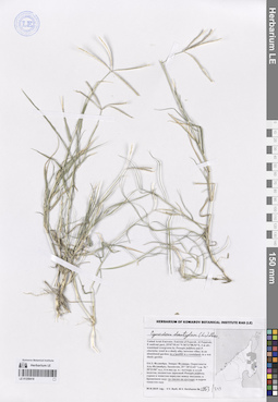
Coelachyrum brevifolium Hochst. & Nees det. Shahid Nawaz Landge, BLAT at 22.01.2026
Additional identifications: Dactyloctenium scindicum Boiss. det. Byalt, Vyacheslav Vyacheslavovich Collectors: Byalt, Vyacheslav Vyacheslavovich; Korshunov, Mikhail Vladimirovich Field collecting number: 1906/619. Collection date: 29.11.2019. Administrative regions: AE - United Arab Emirates. Place of collection: Фуджейра, дорога Аль Даид-Мазафи, окрестности г. Манама, дикорастущее в понижении в конце водотока с водосбором на барханах.Groups of specimens: Образцы общего сектора; Соглашение Минобрнауки №075-15-2021-1056; Бялт В.В.: Флора ФуджейрыOriginal label text: United Arab Emirates. Emirate of Fujaira, Al Dhaid-Masafi Road, environs of Manama, 25°36'10.31"N 55°58'25.48"E, 26 m alt.: wild in the depression at the end of a watercourse watershed on the dunes, – ОАЭ, Фуджейра, дорога Аль Даид-Мазафи, окр. Манама, 25°36'10.31"N 55°58'25.48"E, 26 м н.ур.м.: дикорастущее в понижении в конце водотока с водосбором на барханах, 29 XI 2019, fr., V.V. Byalt & M.V. Korshunov 1906/619
LE 01259427
Launaea massauensis (Fresen.) Sch. Bip. ex Kuntze det. Byalt, Vyacheslav Vyacheslavovich
Collectors: Byalt, Vyacheslav Vyacheslavovich; Korshunov, Vladimir Mikhailovich Field collecting number: s.n. = 368. Collection date: 31.03.2018. Administrative regions: AE - United Arab Emirates. Place of collection: эмират Фуджейра, окрестности пос. Дадна, каменистое ущелье, между валунов.Groups of specimens: Образцы общего сектора; Соглашение Минобрнауки №075-15-2021-1056; Бялт В.В.: Флора ФуджейрыOriginal label text: United Arab Emirates. Emirate of Fujaira, env. of Dhadna, 25°31'02.2"N 56°17'50.2"E, ca. 150–200 m alt.: in the deep gorge; in stony gorge, between stones. – ОАЭ, эмират Фуджейра, окр. пос. Дадна, 25°31'02.2"N 56°17'50.2"E, ca. 150–200 м н. ур. м.: каменистое ущелье, между валунов, 31 III 2018, V.V. Byalt, V.M. Korshunov s.n. = 368
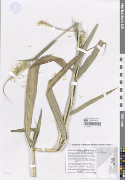
LE 01259426
Digitaria sanguinalis (L.) Scop. det. Byalt, Vyacheslav Vyacheslavovich
Collectors: Byalt, Vyacheslav Vyacheslavovich; Korshunov, Mikhail Vladimirovich Field collecting number: 1836/529. Collection date: 29.11.2019. Administrative regions: AE - United Arab Emirates. Place of collection: Фуджейра, дорога Аль Даид-Мазафи, окрестности пос. Мазафи [точка 358]: сорное в питомнике Салмана.Groups of specimens: Образцы общего сектора; Соглашение Минобрнауки №075-15-2021-1056; Бялт В.В.: Флора ФуджейрыOriginal label text: United Arab Emirates. Emirate of Fujaira, Al Dhaid-Masafi Road, environs of Masafi, 25°17'47.19"N 56°07'28.25"E [point 358]: weed in Salman Nursery. – ОАЭ, Фуджейра, дорога Аль Даид-Мазафи, окр. Мазафи, 25°17'47.19"N 56°07'28.25"E [точка 358]: сорняк в питомнике Салмана, 29 XI 2019, fl., V.V. Byalt & M.V. Korshunov 1836/529
LE 01259425
Cynodon dactylon (L.) Pers. det. Byalt, Vyacheslav Vyacheslavovich
Collectors: Byalt, Vyacheslav Vyacheslavovich; Korshunov, Mikhail Vladimirovich Field collecting number: 1895/638. Collection date: 29.11.2019. Administrative regions: AE - United Arab Emirates. Place of collection: эмират Рас аль Хайма, горы Хаджар, дорога Граграх-Гхуб, около маленькой фермы в горах, у ограды сада, сорное.Groups of specimens: Образцы общего сектора; Соглашение Минобрнауки №075-15-2021-1056; Бялт В.В.: Флора ФуджейрыOriginal label text: United Arab Emirates. Emirate of Ras-al-Khaima, Mts. Hajar, Gragrah-Ghub Road, 25°29'29.35"N 56°03'18.66" E, 159 m alt.:, near small farm in mountains, by fence of garden< weed.– ОАЭ, эмират Рас аль Хайма, горы Хаджар, дорога Граграх-Гхуб, 25°29'29.35"N 56°03'18.66"E, 159 м н.ур.м.: около маленькой фермы в горах, у ограды сада, сорняк, 29 XI 2019, V.V. Byalt & M.V. Korshunov 1895/638
LE 01259424
Cynodon dactylon (L.) Pers. det. Byalt, Vyacheslav Vyacheslavovich
Collectors: Byalt, Vyacheslav Vyacheslavovich; Korshunov, Mikhail Vladimirovich Field collecting number: 1382. Collection date: 21.11.2019. Administrative regions: AE - United Arab Emirates. Place of collection: Фуджейра, г. Дибба, аллея около стадиона и прилегающие улочки на границе с Оманом: сорное на газоне.Groups of specimens: Образцы общего сектора; Соглашение Минобрнауки №075-15-2021-1056; Бялт В.В.: Флора ФуджейрыOriginal label text: United Arab Emirates. Emirate of Fujaira, Dibba, 25°36'59.8"N 56°18'40.02"E, 12 m alt., an alley near the stadium and adjacent streets on the border with Oman: weed on the lawn. – ОАЭ, Фуджейра, Дибба, 25°36'59.8"N 56°18'40.02"E, 12 м н. ур. м., аллея около стадиона и прилегающие улочки на границе с Оманом: сорное на газоне, 21 XI 2019, fl., fr., V.V. Byalt, M.V. Korshunov 1382/36
LE 01259423
Chloris barbata Sw. det. Byalt, Vyacheslav Vyacheslavovich
Collectors: Byalt, Vyacheslav Vyacheslavovich; Korshunov, Mikhail Vladimirovich Field collecting number: 1660/398. Collection date: 25.11.2019. Administrative regions: AE - United Arab Emirates. Place of collection: Фуджейра, окрестности пос. Мерба [точка 345]: пустыри.Groups of specimens: Образцы общего сектора; Соглашение Минобрнауки №075-15-2021-1056; Бялт В.В.: Флора ФуджейрыOriginal label text: United Arab Emirates. Emirate of Fujaira, Mirbah Beach, environs of vill. Mirbah, 25°16'15.29"N 56°22'06.41"E [point 345]: roadsides and along walls and fences in backstreets and gardens; waste places; private yards. – ОАЭ, Фуджейра, окресности пос. Мерба, 25°16'15.29"N 56°22'06.41"E [точка 345]: пустыри, 25 XI 2019 V.V. Byalt & M.V. Korshunov 1660/398
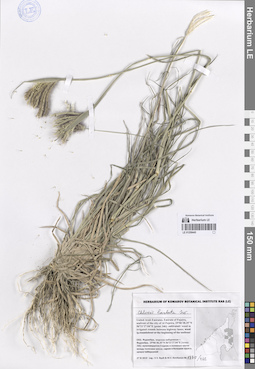
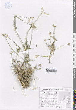
LE 01259422
Heliotropium bacciferum Forssk. det. Byalt, Vyacheslav Vyacheslavovich
Collectors: Byalt, Vyacheslav Vyacheslavovich; Korshunov, Mikhail Vladimirovich Field collecting number: 1723/355. Collection date: 25.11.2019. Administrative regions: AE - United Arab Emirates. Place of collection: Фуджейра, пос. Кидфа [point 343]: пустыри.Groups of specimens: Образцы общего сектора; Соглашение Минобрнауки №075-15-2021-1056; Бялт В.В.: Флора ФуджейрыOriginal label text:United Arab Emirates. Emirate of Fujaira, village Qidfa, 25°17'40.91"N 56°21'28.51"E [point 343]: roadsides and along walls and fences in backstreets; waste places. – ОАЭ, Фуджейра, пос. Кидфа, 25°17'40.91"N 56°21'28.51"E [point 343]: пустыри, 25 XI 2019 V.V. Byalt & M.V. Korshunov 1723/355
Habitat / plant community in location of collecting: пустырьCoordinates (geographic position): 25° 17′ 40.91″ N, 56° 21′ 28.51″ E ±100 mRecord creation: 2023-11-10, Larisa Orlova, PhotoScan D2.Citation: Specimen LE 01259422 // Virtual herbarium of Komarov Botanical Institute RAS — http://re.herbariumle.ru/01259422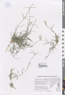
LE 01259421
Cynodon dactylon (L.) Pers. det. Byalt, Vyacheslav Vyacheslavovich
Collectors: Byalt, Vyacheslav Vyacheslavovich; Korshunov, Mikhail Vladimirovich Field collecting number: 1485/239. Collection date: 23.11.2019. Administrative regions: AE - United Arab Emirates. Place of collection: Фуджейра, горы Хаджар. Старая дорога Масафи-Дибба, сады в северо-западной окрестности пос. Аль Хала, сорное в частном саду Абдулы.Groups of specimens: Образцы общего сектора; Соглашение Минобрнауки №075-15-2021-1056; Бялт В.В.: Флора ФуджейрыOriginal label text: United Arab Emirates. Mts. Hajar. Old road Masafi-Dibba, gardens in NW environs of vil. Al Khala, 25°29'02.84"N 56°11'22"E, ca. 180 m alt.: weed in the private garden of Abdulah.– ОАЭ, Фуджейра, горы Хаджар. Старая дорога Масафи-Дибба, сады в сев.-зап. окр. пос. Аль Хала, 25 ° 29'02.84 "N 56 ° 11'22" E, ок. 180 м н. ур. м.: сорное в частном саду Абдулы, 23 XI 2019, fl., fr., V.V. Byalt, M.V. Korshunov 1485/239
LE 01259420
Cynodon dactylon (L.) Pers. det. Byalt, Vyacheslav Vyacheslavovich
Collectors: Byalt, Vyacheslav Vyacheslavovich; Korshunov, Mikhail Vladimirovich Field collecting number: 1557. Collection date: 24.11.2019. Administrative regions: AE - United Arab Emirates. Place of collection: Фуджейра, вади Аль Тайба в окрестности г. Фуджейра [точка 342]: сорное в поливных кругах в северной части фермы шейха Хамада II.Groups of specimens: Образцы общего сектора; Соглашение Минобрнауки №075-15-2021-1056; Бялт В.В.: Флора ФуджейрыOriginal label text: United Arab Emirates. Emirate of Fujaira, Al Taiba in environs of the city of Al Fujeira, 25°09'29.6"N 56°17'31"E [point 342]: weed in irrigated places in N part of farm of the Sheikh Khamad II. – ОАЭ, Фуджейра, Аль Тайба в окр. г. Фуджейра, 25°09'29.6"N 56°17'31"E, [точка 342]: сорняк в поливных кругах в N части фермы шейха Хамада II, 24 XI 2019, fl., V.V. Byalt & M.V. Korshunov 1557
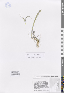
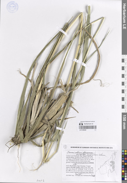
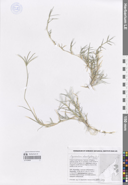
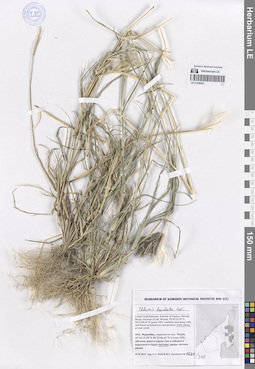
LE 01259419
Lolium rigidum Gaudin det. Byalt, Vyacheslav Vyacheslavovich at 02.11.2023
Collectors: Byalt, Vyacheslav Vyacheslavovich; Korshunov, Mikhail Vladimirovich Field collecting number: s.n. Collection date: 13.03.2020. Administrative regions: AE - United Arab Emirates. Place of collection: Fujairah Emirate, Al Tawyeen (Taween) area, small village 0.8 km West-North-West to mountain peak [point 707]: weed in private garden.Groups of specimens: Образцы общего сектора; Соглашение Минобрнауки №075-15-2021-1056; Бялт В.В.: Флора ФуджейрыOriginal label text: United Arab Emirates, Fujairah Emirate, Al Tawyeen (Taween) area, small village 0.8 km West-North-West to mountain peak. 25°38'59.41"N, 56° 7'17.88"E, elevation 1360 m. [point 707]: weed in private garden, 13 III 2020, V.V. Byalt, M.V. Korshunov s.n.
LE 01259418
Cynodon dactylon (L.) Pers. det. Byalt, Vyacheslav Vyacheslavovich
Collectors: Byalt, Vyacheslav Vyacheslavovich; Korshunov, Mikhail Vladimirovich Field collecting number: 1953/719. Collection date: 30.11.2019. Administrative regions: AE - United Arab Emirates. Place of collection: Фуджейра. Эмират Фуджара. Аль-Фуджайра, восточная приморская часть, свалка на пустыре.Groups of specimens: Образцы общего сектора; Соглашение Минобрнауки №075-15-2021-1056; Бялт В.В.: Флора ФуджейрыOriginal label text: United Arab Emirates. Emirate of Fujarah. Al Fujairah, E seafront part, 25°07'55.41"N 56°21'08.54"E, 4 m alt.: in landfill in a wastreland. – ОАЭ, Фуджейра. Эмират Фуджара. Аль-Фуджайра, вост. приморская часть, 25°07'55.41"N 56°21'08.54"E, 4 м над ур. м.: свалка на пустыре, 30 XI 2019, fl., V.V. Byalt, M.V. Korshunov 1953/719
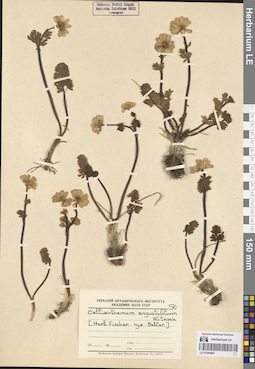
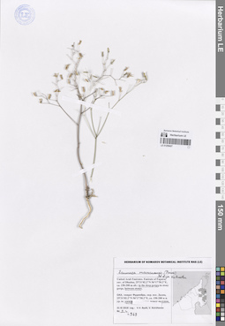
LE 01264084
Callianthemum rutifolium C.A.Mey. var. sajanense Rgl.
Groups of specimens: Образцы сектора Средней Азии; Типовые образцы сектора Средней Азии; Соглашение Минобрнауки №075-15-2021-1056Record creation: 2023-11-10, Mariya Sheludyakova, PhotoScan D2. Part6Citation: Specimen LE 01264084 // Virtual herbarium of Komarov Botanical Institute RAS — http://re.herbariumle.ru/01264084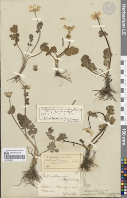
LE 01264083
Callianthemum rutifolium C.A.Mey. var. sajanense Rgl.
Groups of specimens: Образцы сектора Средней Азии; Типовые образцы сектора Средней Азии; Соглашение Минобрнауки №075-15-2021-1056Record creation: 2023-11-10, Mariya Sheludyakova, PhotoScan D2. Part6Citation: Specimen LE 01264083 // Virtual herbarium of Komarov Botanical Institute RAS — http://re.herbariumle.ru/01264083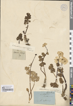
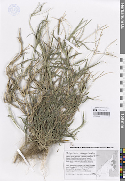
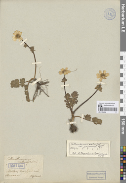
LE 01264082
Callianthemum angustifolium Witasek
Groups of specimens: Образцы сектора Средней Азии; Типовые образцы сектора Средней Азии; Соглашение Минобрнауки №075-15-2021-1056Record creation: 2023-11-10, Mariya Sheludyakova, PhotoScan D2. Part6Citation: Specimen LE 01264082 // Virtual herbarium of Komarov Botanical Institute RAS — http://re.herbariumle.ru/01264082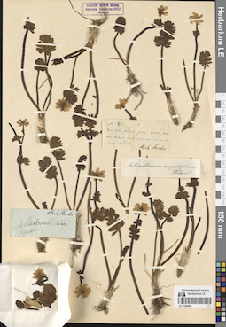
LE 01264081
Callianthemum angustifolium Witasek
Groups of specimens: Образцы сектора Средней Азии; Типовые образцы сектора Средней Азии; Соглашение Минобрнауки №075-15-2021-1056Record creation: 2023-11-10, Mariya Sheludyakova, PhotoScan D2. Part6Citation: Specimen LE 01264081 // Virtual herbarium of Komarov Botanical Institute RAS — http://re.herbariumle.ru/01264081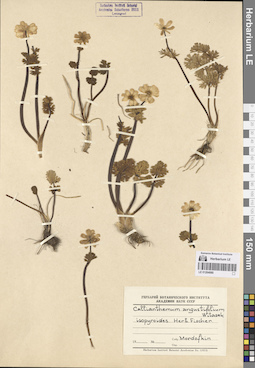
LE 01264080
Callianthemum angustifolium Witasek
Groups of specimens: Образцы сектора Средней Азии; Типовые образцы сектора Средней Азии; Соглашение Минобрнауки №075-15-2021-1056Record creation: 2023-11-10, Mariya Sheludyakova, PhotoScan D2. Part6Citation: Specimen LE 01264080 // Virtual herbarium of Komarov Botanical Institute RAS — http://re.herbariumle.ru/01264080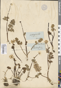
LE 01264079
Callianthemum angustifolium Witasek
Groups of specimens: Образцы сектора Средней Азии; Типовые образцы сектора Средней Азии; Соглашение Минобрнауки №075-15-2021-1056Record creation: 2023-11-10, Mariya Sheludyakova, PhotoScan D2. Part6Citation: Specimen LE 01264079 // Virtual herbarium of Komarov Botanical Institute RAS — http://re.herbariumle.ru/01264079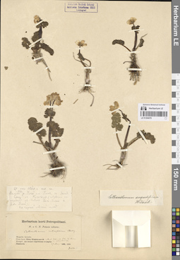
LE 01264078
Callianthemum angustifolium Witasek
Groups of specimens: Образцы сектора Средней Азии; Типовые образцы сектора Средней Азии; Соглашение Минобрнауки №075-15-2021-1056Record creation: 2023-11-10, Mariya Sheludyakova, PhotoScan D2. Part6Citation: Specimen LE 01264078 // Virtual herbarium of Komarov Botanical Institute RAS — http://re.herbariumle.ru/01264078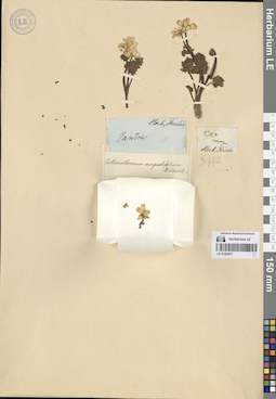
LE 01264077
Callianthemum angustifolium Witasek
Groups of specimens: Образцы сектора Средней Азии; Типовые образцы сектора Средней Азии; Соглашение Минобрнауки №075-15-2021-1056Record creation: 2023-11-10, Mariya Sheludyakova, PhotoScan D2. Part6Citation: Specimen LE 01264077 // Virtual herbarium of Komarov Botanical Institute RAS — http://re.herbariumle.ru/01264077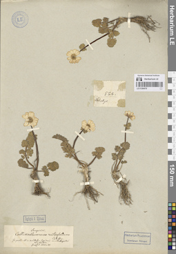
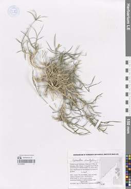
LE 01264076
Callianthemum angustifolium Witasek
Additional identifications: Callianthemum rutifolium C.A.Mey. Administrative regions: KZ - Kazakhstan. Place of collection: горы Тарбагатай.Groups of specimens: Образцы сектора Средней Азии; Типовые образцы сектора Средней Азии; Соглашение Минобрнауки №075-15-2021-1056Record creation: 2023-11-10, Mariya Sheludyakova, PhotoScan D2. Part6Citation: Specimen LE 01264076 // Virtual herbarium of Komarov Botanical Institute RAS — http://re.herbariumle.ru/01264076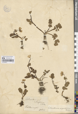
LE 01264075
Callianthemum angustifolium Witasek
Additional identifications: Callianthemum rutifolium C.A.Mey. Groups of specimens: Образцы сектора Средней Азии; Типовые образцы сектора Средней Азии; Соглашение Минобрнауки №075-15-2021-1056Record creation: 2023-11-10, Mariya Sheludyakova, PhotoScan D2. Part6Citation: Specimen LE 01264075 // Virtual herbarium of Komarov Botanical Institute RAS — http://re.herbariumle.ru/01264075
LE 01264073
Callianthemum angustifolium Witasek
Groups of specimens: Образцы сектора Средней Азии; Типовые образцы сектора Средней Азии; Соглашение Минобрнауки №075-15-2021-1056Record creation: 2023-11-10, Mariya Sheludyakova, PhotoScan D2. Part6Citation: Specimen LE 01264073 // Virtual herbarium of Komarov Botanical Institute RAS — http://re.herbariumle.ru/01264073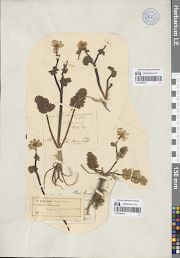
LE 01264074
Callianthemum angustifolium Witasek
Groups of specimens: Образцы сектора Средней Азии; Типовые образцы сектора Средней Азии; Соглашение Минобрнауки №075-15-2021-1056Record creation: 2023-11-10, Mariya Sheludyakova, PhotoScan D2. Part6Citation: Specimen LE 01264074 // Virtual herbarium of Komarov Botanical Institute RAS — http://re.herbariumle.ru/01264074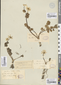
LE 01264070
Callianthemum angustifolium Witasek
Groups of specimens: Образцы сектора Средней Азии; Типовые образцы сектора Средней Азии; Соглашение Минобрнауки №075-15-2021-1056Record creation: 2023-11-10, Mariya Sheludyakova, PhotoScan D2. Part6Citation: Specimen LE 01264070 // Virtual herbarium of Komarov Botanical Institute RAS — http://re.herbariumle.ru/01264070
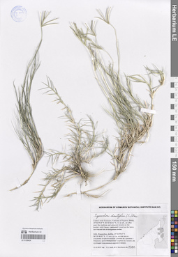
LE 01264072
Callianthemum angustifolium Witasek
Administrative regions: KZ - Kazakhstan. Place of collection: горы Тарбагатай.Groups of specimens: Образцы сектора Средней Азии; Типовые образцы сектора Средней Азии; Соглашение Минобрнауки №075-15-2021-1056Record creation: 2023-11-10, Mariya Sheludyakova, PhotoScan D2. Part6Citation: Specimen LE 01264072 // Virtual herbarium of Komarov Botanical Institute RAS — http://re.herbariumle.ru/01264072
LE 01264071
Callianthemum angustifolium Witasek
Groups of specimens: Образцы сектора Средней Азии; Типовые образцы сектора Средней Азии; Соглашение Минобрнауки №075-15-2021-1056Record creation: 2023-11-10, Mariya Sheludyakova, PhotoScan D2. Part6Citation: Specimen LE 01264071 // Virtual herbarium of Komarov Botanical Institute RAS — http://re.herbariumle.ru/01264071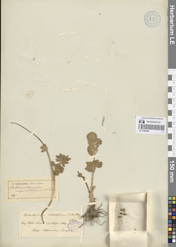
LE 01264069
Callianthemum angustifolium Witasek
Groups of specimens: Образцы сектора Средней Азии; Типовые образцы сектора Средней Азии; Соглашение Минобрнауки №075-15-2021-1056Record creation: 2023-11-10, Mariya Sheludyakova, PhotoScan D2. Part6Citation: Specimen LE 01264069 // Virtual herbarium of Komarov Botanical Institute RAS — http://re.herbariumle.ru/01264069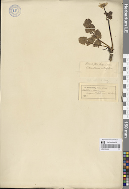
LE 01264068
Callianthemum angustifolium Witasek
Groups of specimens: Образцы сектора Средней Азии; Типовые образцы сектора Средней Азии; Соглашение Минобрнауки №075-15-2021-1056Record creation: 2023-11-10, Mariya Sheludyakova, PhotoScan D2. Part6Citation: Specimen LE 01264068 // Virtual herbarium of Komarov Botanical Institute RAS — http://re.herbariumle.ru/01264068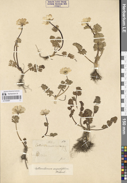
LE 01264067
Callianthemum angustifolium Witasek
Groups of specimens: Образцы сектора Средней Азии; Типовые образцы сектора Средней Азии; Соглашение Минобрнауки №075-15-2021-1056Record creation: 2023-11-10, Mariya Sheludyakova, PhotoScan D2. Part6Citation: Specimen LE 01264067 // Virtual herbarium of Komarov Botanical Institute RAS — http://re.herbariumle.ru/01264067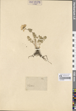
LE 01264066
Callianthemum angustifolium Witasek
Groups of specimens: Образцы сектора Средней Азии; Типовые образцы сектора Средней Азии; Соглашение Минобрнауки №075-15-2021-1056Record creation: 2023-11-10, Mariya Sheludyakova, PhotoScan D2. Part6Citation: Specimen LE 01264066 // Virtual herbarium of Komarov Botanical Institute RAS — http://re.herbariumle.ru/01264066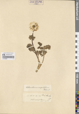
LE 01264065
Callianthemum angustifolium Witasek
Groups of specimens: Образцы сектора Средней Азии; Типовые образцы сектора Средней Азии; Соглашение Минобрнауки №075-15-2021-1056Record creation: 2023-11-10, Mariya Sheludyakova, PhotoScan D2. Part6Citation: Specimen LE 01264065 // Virtual herbarium of Komarov Botanical Institute RAS — http://re.herbariumle.ru/01264065