View
Add
Copy
Edit
Delete
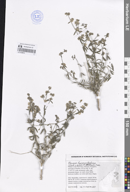
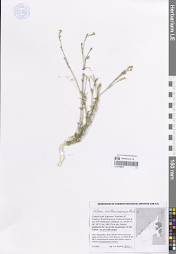
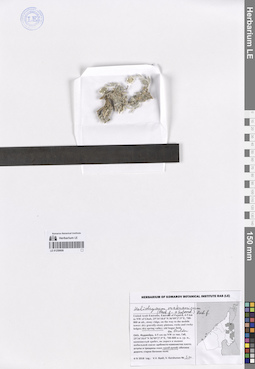
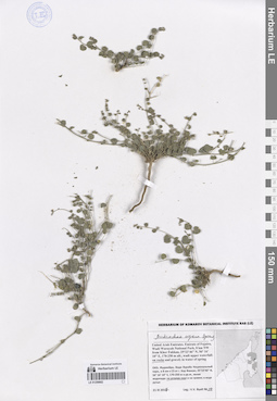
LE 01264086
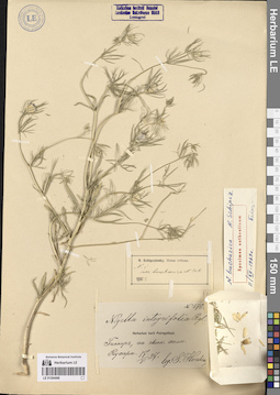
Nigella bucharica Schipcz.
Additional identifications: Nigella integrifolia Regel Groups of specimens: Образцы сектора Средней Азии; Типовые образцы сектора Средней Азии; Соглашение Минобрнауки №075-15-2021-1056Record creation: 2023-11-11, Mariya Sheludyakova, PhotoScan D2.Citation: Specimen LE 01264086 // Virtual herbarium of Komarov Botanical Institute RAS — http://re.herbariumle.ru/01264086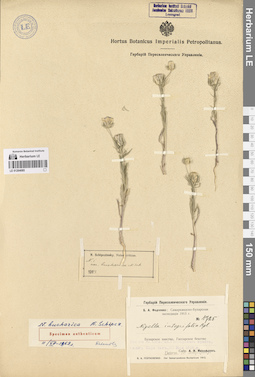
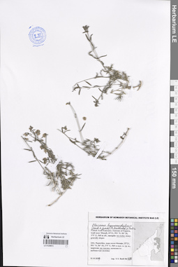
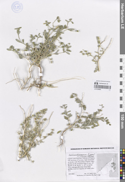
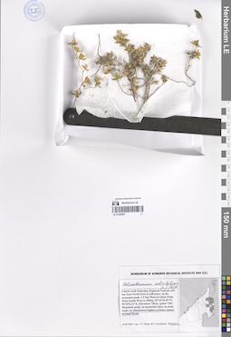
LE 01264085
Nigella bucharica Schipcz.
Additional identifications: Nigella integrifolia Regel Administrative regions: TJ - Tajikistan. Place of collection: окрестности города Гиссар.Groups of specimens: Образцы сектора Средней Азии; Типовые образцы сектора Средней Азии; Соглашение Минобрнауки №075-15-2021-1056Record creation: 2023-11-11, Mariya Sheludyakova, PhotoScan D2.Citation: Specimen LE 01264085 // Virtual herbarium of Komarov Botanical Institute RAS — http://re.herbariumle.ru/01264085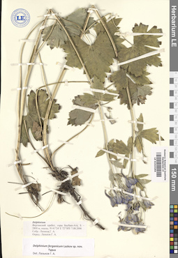
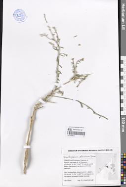
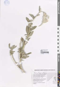
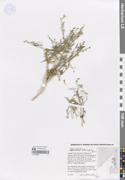
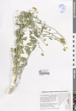
LE 01010264
Delphinium ferganicum Lazkov
Administrative regions: KG - Kyrgyzstan. Place of collection: Ферганский хребет, горы Баубаш-Ата.Groups of specimens: Образцы сектора Средней Азии; Типовые образцы сектора Средней Азии; Соглашение Минобрнауки №075-15-2021-1056Record creation: 2023-11-11, Mariya Sheludyakova, PhotoScan D2.Citation: Specimen LE 01010264 // Virtual herbarium of Komarov Botanical Institute RAS — http://re.herbariumle.ru/01010264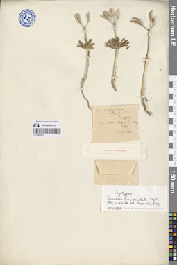
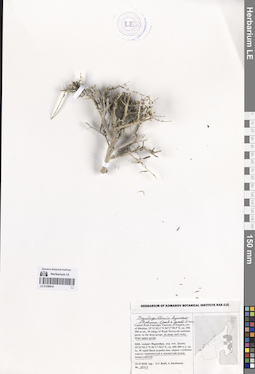
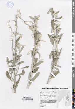
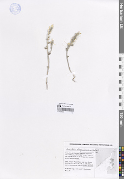
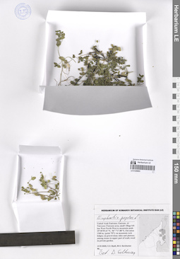
LE 00052415
Syntype of Eranthis longistipitata Regel det. Regel, Eduard August von
Collectors: Sewerzov [Severtsov], Nikolai Alekseevich Collection date: 04.04. Administrative regions: TJ - Viloyati Sughd. Groups of specimens: Образцы сектора Средней Азии; Типовые образцы сектора Средней Азии; Соглашение Минобрнауки №075-15-2021-1056Coordinates (geographic position): 40° 19′ 59.88″ N, 69° 30′ 0″ EComment:Протолог на с. 244: https://moip-bio.msu.ru/wp-content/uploads/moip_1870.pdf
Record creation: 2023-11-11, Mariya Sheludyakova, PhotoScan D2.Citation: Specimen LE 00052415 // Virtual herbarium of Komarov Botanical Institute RAS — http://re.herbariumle.ru/00052415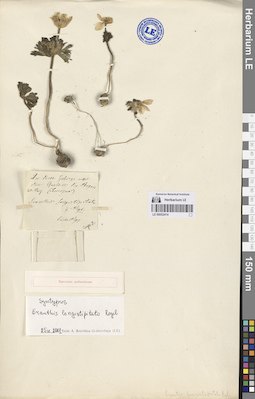
LE 00052414
Syntype of Eranthis longistipitata Regel det. Regel, Eduard August von
Collectors: Sewerzov [Severtsov], Nikolai Alekseevich Collection date: 20.05. Administrative regions: TJ - Tajikistan. Groups of specimens: Образцы сектора Средней Азии; Типовые образцы сектора Средней Азии; Соглашение Минобрнауки №075-15-2021-1056Original label text:Quellen des Bugun
Comment: Протолог на с. 244: https://moip-bio.msu.ru/wp-content/uploads/moip_1870.pdf
Record creation: 2023-11-11, Mariya Sheludyakova, PhotoScan D2.Citation: Specimen LE 00052414 // Virtual herbarium of Komarov Botanical Institute RAS — http://re.herbariumle.ru/00052414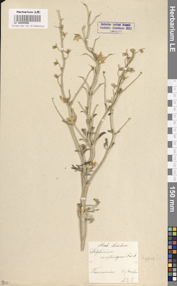
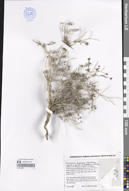
LE 00050986
Delphinium camptocarpum Fisch. & C.A. Mey.
Groups of specimens: Образцы сектора Средней Азии; Типовые образцы сектора Средней Азии; Соглашение Минобрнауки №075-15-2021-1056Record creation: 2023-11-11, Mariya Sheludyakova, PhotoScan D2.Citation: Specimen LE 00050986 // Virtual herbarium of Komarov Botanical Institute RAS — http://re.herbariumle.ru/00050986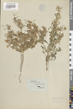
LE 00050985
Delphinium camptocarpum Fisch. & C.A. Mey.
Groups of specimens: Образцы сектора Средней Азии; Типовые образцы сектора Средней Азии; Соглашение Минобрнауки №075-15-2021-1056Record creation: 2023-11-11, Mariya Sheludyakova, PhotoScan D2.Citation: Specimen LE 00050985 // Virtual herbarium of Komarov Botanical Institute RAS — http://re.herbariumle.ru/00050985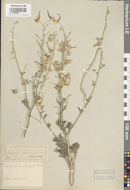
LE 00050984
Delphinium camptocarpum Fisch. & C.A. Mey.
Groups of specimens: Образцы сектора Средней Азии; Типовые образцы сектора Средней Азии; Соглашение Минобрнауки №075-15-2021-1056Record creation: 2023-11-11, Mariya Sheludyakova, PhotoScan D2.Citation: Specimen LE 00050984 // Virtual herbarium of Komarov Botanical Institute RAS — http://re.herbariumle.ru/00050984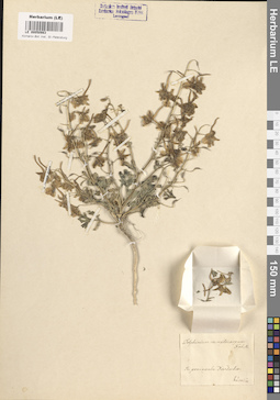
LE 00050983
Delphinium camptocarpum Fisch. & C.A. Mey.
Groups of specimens: Образцы сектора Средней Азии; Типовые образцы сектора Средней Азии; Соглашение Минобрнауки №075-15-2021-1056Record creation: 2023-11-11, Mariya Sheludyakova, PhotoScan D2.Citation: Specimen LE 00050983 // Virtual herbarium of Komarov Botanical Institute RAS — http://re.herbariumle.ru/00050983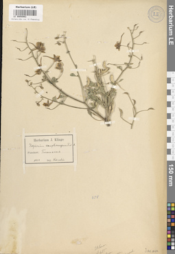
LE 00050982
Delphinium camptocarpum Fisch. & C.A. Mey.
Groups of specimens: Образцы сектора Средней Азии; Типовые образцы сектора Средней Азии; Соглашение Минобрнауки №075-15-2021-1056Record creation: 2023-11-11, Mariya Sheludyakova, PhotoScan D2.Citation: Specimen LE 00050982 // Virtual herbarium of Komarov Botanical Institute RAS — http://re.herbariumle.ru/00050982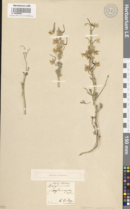
LE 00050981
Delphinium camptocarpum Fisch. & C.A. Mey.
Groups of specimens: Образцы сектора Средней Азии; Типовые образцы сектора Средней Азии; Соглашение Минобрнауки №075-15-2021-1056Record creation: 2023-11-11, Mariya Sheludyakova, PhotoScan D2.Citation: Specimen LE 00050981 // Virtual herbarium of Komarov Botanical Institute RAS — http://re.herbariumle.ru/00050981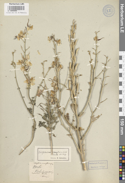
LE 00050980
Delphinium camptocarpum Fisch. & C.A. Mey.
Groups of specimens: Образцы сектора Средней Азии; Типовые образцы сектора Средней Азии; Соглашение Минобрнауки №075-15-2021-1056Record creation: 2023-11-11, Mariya Sheludyakova, PhotoScan D2.Citation: Specimen LE 00050980 // Virtual herbarium of Komarov Botanical Institute RAS — http://re.herbariumle.ru/00050980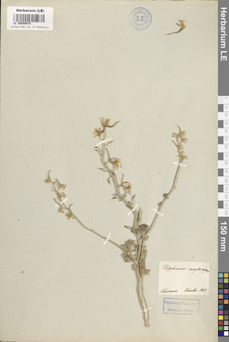
LE 00050878
Delphinium camptocarpum Fisch. & C.A. Mey.
Groups of specimens: Образцы сектора Средней Азии; Типовые образцы сектора Средней Азии; Соглашение Минобрнауки №075-15-2021-1056Record creation: 2023-11-11, Mariya Sheludyakova, PhotoScan D2.Citation: Specimen LE 00050878 // Virtual herbarium of Komarov Botanical Institute RAS — http://re.herbariumle.ru/00050878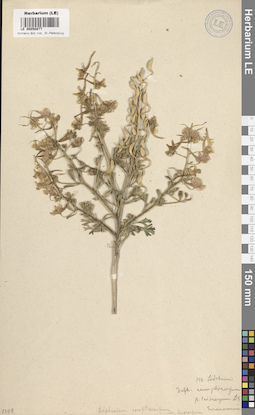
LE 00050877
Delphinium camptocarpum Fisch. & C.A. Mey.
Groups of specimens: Образцы сектора Средней Азии; Типовые образцы сектора Средней Азии; Соглашение Минобрнауки №075-15-2021-1056Record creation: 2023-11-11, Mariya Sheludyakova, PhotoScan D2.Citation: Specimen LE 00050877 // Virtual herbarium of Komarov Botanical Institute RAS — http://re.herbariumle.ru/00050877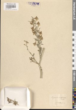
LE 00050876
Delphinium camptocarpum Fisch. & C.A. Mey.
Groups of specimens: Образцы сектора Средней Азии; Типовые образцы сектора Средней Азии; Соглашение Минобрнауки №075-15-2021-1056Record creation: 2023-11-11, Mariya Sheludyakova, PhotoScan D2.Citation: Specimen LE 00050876 // Virtual herbarium of Komarov Botanical Institute RAS — http://re.herbariumle.ru/00050876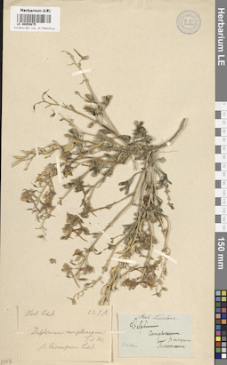
LE 00050875
Delphinium camptocarpum Fisch. & C.A. Mey.
Groups of specimens: Образцы сектора Средней Азии; Типовые образцы сектора Средней Азии; Соглашение Минобрнауки №075-15-2021-1056Record creation: 2023-11-11, Mariya Sheludyakova, PhotoScan D2.Citation: Specimen LE 00050875 // Virtual herbarium of Komarov Botanical Institute RAS — http://re.herbariumle.ru/00050875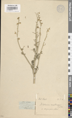
LE 00050874
Delphinium camptocarpum Fisch. & C.A. Mey.
Groups of specimens: Образцы сектора Средней Азии; Типовые образцы сектора Средней Азии; Соглашение Минобрнауки №075-15-2021-1056Record creation: 2023-11-11, Mariya Sheludyakova, PhotoScan D2.Citation: Specimen LE 00050874 // Virtual herbarium of Komarov Botanical Institute RAS — http://re.herbariumle.ru/00050874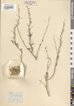
LE 00050873
Delphinium camptocarpum Fisch. & C.A. Mey.
Groups of specimens: Образцы сектора Средней Азии; Типовые образцы сектора Средней Азии; Соглашение Минобрнауки №075-15-2021-1056Record creation: 2023-11-11, Mariya Sheludyakova, PhotoScan D2.Citation: Specimen LE 00050873 // Virtual herbarium of Komarov Botanical Institute RAS — http://re.herbariumle.ru/00050873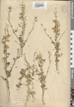
LE 00050872
Delphinium camptocarpum Fisch. & C.A. Mey.
Groups of specimens: Образцы сектора Средней Азии; Типовые образцы сектора Средней Азии; Соглашение Минобрнауки №075-15-2021-1056Record creation: 2023-11-11, Mariya Sheludyakova, PhotoScan D2.Citation: Specimen LE 00050872 // Virtual herbarium of Komarov Botanical Institute RAS — http://re.herbariumle.ru/00050872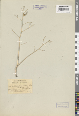
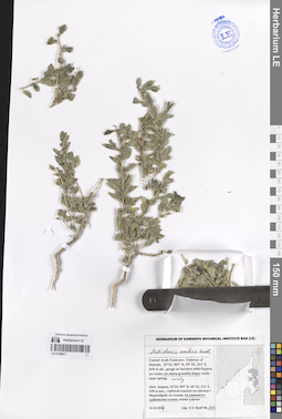
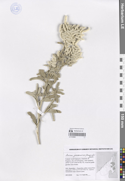
LE 00050814
Delphinium barbatum Bunge
Groups of specimens: Образцы сектора Средней Азии; Типовые образцы сектора Средней Азии; Соглашение Минобрнауки №075-15-2021-1056Record creation: 2023-11-11, Mariya Sheludyakova, PhotoScan D2.Citation: Specimen LE 00050814 // Virtual herbarium of Komarov Botanical Institute RAS — http://re.herbariumle.ru/00050814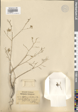
LE 00050813
Delphinium barbatum Bunge
Groups of specimens: Образцы сектора Средней Азии; Типовые образцы сектора Средней Азии; Соглашение Минобрнауки №075-15-2021-1056Record creation: 2023-11-11, Mariya Sheludyakova, PhotoScan D2.Citation: Specimen LE 00050813 // Virtual herbarium of Komarov Botanical Institute RAS — http://re.herbariumle.ru/00050813
LE 00050812
Delphinium barbatum Bunge
Groups of specimens: Образцы сектора Средней Азии; Типовые образцы сектора Средней Азии; Соглашение Минобрнауки №075-15-2021-1056Record creation: 2023-11-11, Mariya Sheludyakova, PhotoScan D2.Citation: Specimen LE 00050812 // Virtual herbarium of Komarov Botanical Institute RAS — http://re.herbariumle.ru/00050812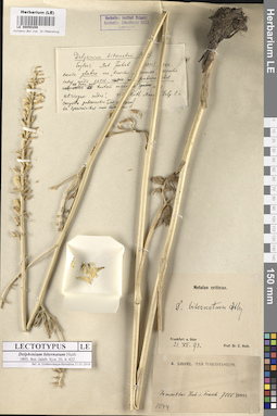
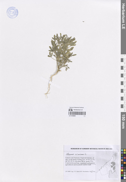
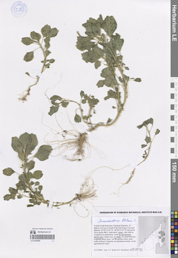
LE 00050208
Delphinium biternatum Huth
Groups of specimens: Образцы сектора Средней Азии; Типовые образцы сектора Средней Азии; Соглашение Минобрнауки №075-15-2021-1056Record creation: 2023-11-11, Mariya Sheludyakova, PhotoScan D2.Citation: Specimen LE 00050208 // Virtual herbarium of Komarov Botanical Institute RAS — http://re.herbariumle.ru/00050208
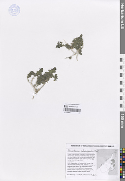
LE 00050194
Delphinium aemulans Nevski
Additional identifications: Delphinium elatum L. Administrative regions: KZ - Kazakhstan. Place of collection: хребет Монрак (Манырак).Groups of specimens: Образцы сектора Средней Азии; Типовые образцы сектора Средней Азии; Соглашение Минобрнауки №075-15-2021-1056Record creation: 2023-11-11, Mariya Sheludyakova, PhotoScan D2.Citation: Specimen LE 00050194 // Virtual herbarium of Komarov Botanical Institute RAS — http://re.herbariumle.ru/00050194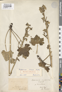
LE 00050191
Delphinium iliense Huth
Groups of specimens: Образцы сектора Средней Азии; Типовые образцы сектора Средней Азии; Соглашение Минобрнауки №075-15-2021-1056Record creation: 2023-11-11, Mariya Sheludyakova, PhotoScan D2.Citation: Specimen LE 00050191 // Virtual herbarium of Komarov Botanical Institute RAS — http://re.herbariumle.ru/00050191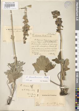
LE 00050190
Delphinium iliense Huth
Groups of specimens: Образцы сектора Средней Азии; Типовые образцы сектора Средней Азии; Соглашение Минобрнауки №075-15-2021-1056Record creation: 2023-11-11, Mariya Sheludyakova, PhotoScan D2.Citation: Specimen LE 00050190 // Virtual herbarium of Komarov Botanical Institute RAS — http://re.herbariumle.ru/00050190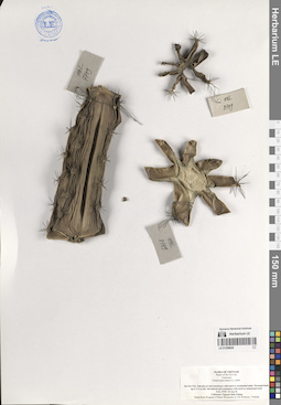
LE 01259620
Cereus peruvianus (L.) Mill. det. Khang Sinh Nguyen
Collectors: Khang Sinh Nguyen Field collecting number: HAL 8709. Collection date: 04.06.2006. Administrative regions: VN - Thanh Pho Ha Noi. Subregion: Ha Noi City. Place of collection: Ha Noi City. Introduced and sometimes cultivated as ornamental plant.Groups of specimens: Образцы общего сектора; Соглашение Минобрнауки №075-15-2021-1056; Flora of Vietnam; L. V. Averyanov specimens; L. V. Averyanov herbariumOriginal label text:Flora of Vietnam
Plants of Ha Noi City
Cactaceae
Cereus peruvianus (L.) Merr.
Ha Noi City. Introduced and sometimes cultivated as ornamental plant. Perennial herb, up to 3-4 m tall. Introduced and sometimes cultivated as ornamental herb. HAL 8709 04 Jun 06. Collectors: Nguyen Sinh Khang. Grant from Program of Basic Researchs in Life Sciences, Vietnam
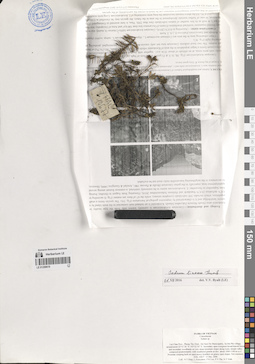
LE 01259619
Sedum lineare Thunb. det. Byalt, Vyacheslav Vyacheslavovich at 21.12.2016
Collectors: Tien Hiep Nguyen; Averyanov, Leonid Vladimirovich; Phan Ke Loc; The Van Pham; Vinh Tien Nguyen Field collecting number: HAL10677. Collection date: 13.12.2006. Administrative regions: VN - Tinh Lai Chau. Subregion: Phong Tho District, Sin Suoi Ho Municipality. Place of collection: Lai Chau Prov., Phong Tho Distr., Sin Suoi Ho Municipality, Sa Ma Pho village, around point 22°32'26'' N 103°32'05'' E. Secondary open evergreen broad-leaved forest and secondary woodlands on very steep mountain slopes along rocky stream valley composed predominantly with weathered granite at elevation about 1000-1100 m a.s.l.Groups of specimens: Образцы общего сектора; Соглашение Минобрнауки №075-15-2021-1056; Flora of Vietnam; L. V. Averyanov specimens; L. V. Averyanov herbariumOriginal label text:Flora of Vietnam.
Crassulaceae
Sedum sp.
Lai Chau Prov., Phong Tho Distr., Sin Suoi Ho Municipality, Sa Ma Pho village, around point 22°32'26'' N 103°32'05'' E. Secondary open evergreen broad-leaved forest and secondary woodlands on very steep mountain slopes along rocky stream valley composed predominantly with weathered granite at elev. about 1000-1100 m a.s.l. Prostrate creeping herb on open mossy boulders on grassy open slopes. Not common. HAL 10677 13 Dec. 2006. Coll.: N.T. Hiep, L. Averyanov, P. K. Loc, P. V. The, N.T. Vinh
LE 01259618
Dipterigium glaucum Decne. det. Byalt, Vyacheslav Vyacheslavovich
Collectors: Byalt, Vyacheslav Vyacheslavovich Field collecting number: 471. Collection date: 30.03.2017. Administrative regions: AE - United Arab Emirates. Place of collection: Фуджейра, окрестности г. Манама, барханы.Groups of specimens: Образцы общего сектора; Соглашение Минобрнауки №075-15-2021-1056; Бялт В.В.: Флора ФуджейрыOriginal label text: United Arab Emirates. Emirate of Fujaira, environs of Al Manama, 25°20,020’ N, 56° 11,847’ E: on the sandy dunes (barkhans). – ОАЭ, Фуджейра, окрестности г. Манама, 25°20,020’ N, 56° 11,847’ E: на барханах, 30 III 2017, V.V. Byalt 471
LE 01259617
Anticharis arabica Endl. det. Byalt, Vyacheslav Vyacheslavovich
Collectors: Byalt, Vyacheslav Vyacheslavovich Field collecting number: 509. Collection date: 31.03.2017. Administrative regions: AE - United Arab Emirates. Place of collection: Шаржа, глубокое ущелье на границе с Фуджейрой: каменисто-щебнистый склон.Groups of specimens: Образцы общего сектора; Соглашение Минобрнауки №075-15-2021-1056; Бялт В.В.: Флора ФуджейрыOriginal label text: United Arab Emirates. Emirate of Sharjah, 25°22, 997’ N, 56° 01, 211’ E, 470 m alt., gorge on borders with Fujaira: on stony-gravelly slope.– ОАЭ, Шаржа, 25°22, 997’ N, 56° 01, 211’ E, 470 м выс., глубокое ущелье на границе с Фуджейрой: на каменисто-щебнистом склоне, 31 III 2017, fl., V.V. Byalt 509
LE 01259616
Pseudogaillonia hymenostephana (Jaub. et Spach) Lincz. det. Byalt, Vyacheslav Vyacheslavovich
Collectors: Byalt, Vyacheslav Vyacheslavovich; Korshunov, Vladimir Mikhailovich Field collecting number: 1043. Collection date: 31.03.2018. Administrative regions: AE - United Arab Emirates. Place of collection: эмират Фуджейра, окрестности пос. Дадна, западный край Вади Вурайя национального парка: каменистый и скалистый склон выше ущелья.Groups of specimens: Образцы общего сектора; Соглашение Минобрнауки №075-15-2021-1056; Бялт В.В.: Флора ФуджейрыOriginal label text: United Arab Emirates. Emirate of Fujaira, env. of Dhadna, 25°31'02.2"N 56°17'50.5"E, ca. 200-300 m alt., W edege of Wadi Wurayah national park: on stony and rocky slope upper gorge. – ОАЭ, эмират Фуджейра, окр. пос. Дадна, 25°31'02.2"N 56°17'50.5"E, ca. 200-300 м н. ур. м., W край Вади вурайя нац. парка: каменистый и скалистый склон выше ущелья, 31 III 2018, V.V. Byalt, V. Korshunov 1043
LE 01259615
Plocama hymenostephana (Jaub. et Spach) M.Backlund et Thulin det. Byalt, Vyacheslav Vyacheslavovich
Collectors: Byalt, Vyacheslav Vyacheslavovich Field collecting number: 117. Collection date: 23.03.2017. Administrative regions: AE - United Arab Emirates. Place of collection: Фуджейра, Вади Вурайа Национальный парк, в 8 км северо-западнее г. Хор Факкан, выше вади: на уступах скал; малый боковой вади.Groups of specimens: Образцы общего сектора; Соглашение Минобрнауки №075-15-2021-1056; Бялт В.В.: Флора ФуджейрыOriginal label text: United Arab Emirates. Emirate of Fujaira, Wadi Wurayah National Park, 8 km NW from Khor Fakkan, 25°23, 366’ N, 56° 18, 356’ E, upper wadi: on rocks and stony slopes; small lateral wadi.– ОАЭ, Фуджейра, Вади Вурайа Национальный парк, в 8 км к СЗ от г. Хор Факкан, 25°23, 366’ N, 56° 18, 356’ E, выше вади: на уступах скал; малый боковой вади, 23 III 2017, V.V. Byalt 117
LE 01259614
Plocama hymenostephana (Jaub. et Spach) M.Backlund et Thulin det. Byalt, Vyacheslav Vyacheslavovich
Collectors: Byalt, Vyacheslav Vyacheslavovich Field collecting number: 287. Collection date: 26.03.2017. Administrative regions: AE - United Arab Emirates. Place of collection: Фуджейра, окрестности г. Дадна, широкая горная долина и горные склоны: скалы и каменистые склоны.Groups of specimens: Образцы общего сектора; Соглашение Минобрнауки №075-15-2021-1056; Бялт В.В.: Флора ФуджейрыOriginal label text: United Arab Emirates. Emirate of Fujaira, environs of Dadna, 25°24, 018’ N, 56° 17,475’ E: wide mountain valley and mountain slopes: on rocks and stony slopes. – ОАЭ, Фуджейра, окрестности г. Дадна, 25°24, 018’ N, 56° 17,475’ E: широкая горная долина и горные склоны: на скалах и каменистых склонах. 26-27 III 2017, V.V. Byalt 287
LE 01259613
Plocama hymenostephana (Jaub. et Spach) M.Backlund et Thulin det. Byalt, Vyacheslav Vyacheslavovich
Collectors: Byalt, Vyacheslav Vyacheslavovich Field collecting number: 488. Collection date: 31.03.2017. Administrative regions: AE - United Arab Emirates. Place of collection: Фуджейра, вади около пос. Мазафи, на скалах.Groups of specimens: Образцы общего сектора; Соглашение Минобрнауки №075-15-2021-1056; Бялт В.В.: Флора ФуджейрыOriginal label text: United Arab Emirates. Emirate of Fujaira, wadi near Musafi, 25°21, 991’ N, 56° 10, 375’ E, 560 m alt., on rocks.– ОАЭ, Фуджейра, вади около Мазафи, 25°21, 991’ N, 56° 10, 375’ E, 560 м выс. н. ур. м., на скалах, 31 III 2017, V.V. Byalt 488
LE 01259612
Aerva javanica (Burm. f.) Juss. ex Schult. det. Byalt, Vyacheslav Vyacheslavovich
Collectors: Byalt, Vyacheslav Vyacheslavovich; Korshunov, Mikhail Vladimirovich Field collecting number: 1452. Collection date: 22.11.2019. Administrative regions: AE - United Arab Emirates. Place of collection: Фуджейра, 0,3 км западнее г. Кальба, Кальбинская дамба: сухие каменисто-щебнистые берега озера (пруда).Groups of specimens: Образцы общего сектора; Соглашение Минобрнауки №075-15-2021-1056; Бялт В.В.: Флора ФуджейрыOriginal label text: United Arab Emirates. Emirate of Fujaira, 0.3 km to W from Kalba, 25°00'33.51"N 56°19'17.58"E, 48 m alt., Kalba dam: dry gravel-stony shores shores of lake.– ОАЭ, Фуджейра, 0,3 км к западу от Кальбы, 25°00'33.51"N 56°19'17.58"E, 48 м н.ур.м., Кальбинская дамба: сухие каменисто-щебнистые берега озера (пруда), 22 XI 2019, fl., fr., V.V. Byalt, M.V. Korshunov 1452
LE 01259611
Aerva javanica (Burm. f.) Juss. ex Schult. det. Byalt, Vyacheslav Vyacheslavovich
Collectors: Byalt, Vyacheslav Vyacheslavovich; Korshunov, Mikhail Vladimirovich Field collecting number: 1588. Collection date: 24.11.2019. Administrative regions: AE - United Arab Emirates. Place of collection: Фуджейра, вади Аль Тайба в окрестности г. Фуджейра, сорное в поливных кругах в северной части фермы шейха Хамада II [точка 342].Groups of specimens: Образцы общего сектора; Соглашение Минобрнауки №075-15-2021-1056; Бялт В.В.: Флора ФуджейрыOriginal label text: United Arab Emirates. Emirate of Fujaira, Al Taiba in environs of the city of Al Fujeira, 25°09'29.6"N 56°17'31"E: weed in irrigated places in N part of farm of the Sheikh Khamad II [point 342]. – ОАЭ, Фуджейра, Аль Тайба в окр. г. Фуджейра, 25°09'29.6"N 56°17'31"E: сорняк в поливных кругах в N части фермы шейха Хамада II [точка 342], 24 XI 2019, fl., V.V. Byalt & M.V. Korshunov 1588
LE 01259610
Silene austroiranica Rech.f., Aellen & Esfand. det. Byalt, Vyacheslav Vyacheslavovich
Collectors: Byalt, Vyacheslav Vyacheslavovich Field collecting number: 496a. Collection date: 03.04.2018. Administrative regions: AE - United Arab Emirates. Place of collection: Фуджейра, Вади Вурайа Национальный парк, в 8 км северо-западнее г. Хор Факкан, огороженные загоны для таров в горах: каменистый склон.Groups of specimens: Образцы общего сектора; Соглашение Минобрнауки №075-15-2021-1056; Бялт В.В.: Флора ФуджейрыOriginal label text: United Arab Emirates. Emirate of Fujaira, Wadi Wurayah National Park, 8 km NW from Khor Fakkan, ca. 25°23’ N, 56° 18’ E, ca. 160-170 m alt., fenced paddocks for tar in the mountains: on gravelly slopes.– ОАЭ, Фуджейра, Вади Вурайа Национальный парк, в 8 км к СЗ от г. Хор Факкан, ca. 25°23’ N, 56° 18’ E, огороженные загоны для таров в горах: на каменистом склоне, 3 IV 2018, fl., fr., V.V. Byalt 496a
LE 01259609
Arnebia hispidissima (Lehm.) DC. det. Byalt, Vyacheslav Vyacheslavovich
Collectors: Byalt, Vyacheslav Vyacheslavovich; Korshunov, Vladimir Mikhailovich Field collecting number: s.n. Collection date: 31.03.2018. Administrative regions: AE - United Arab Emirates. Place of collection: эмират Фуджейра, окрестности пос. Дадна, между валунов.Groups of specimens: Образцы общего сектора; Соглашение Минобрнауки №075-15-2021-1056; Бялт В.В.: Флора ФуджейрыOriginal label text: United Arab Emirates. Emirate of Fujaira, env. of Dhadna, 25°31'02.2"N 56°17'50.2"E, ca. 150–200 m alt.: between stones. – ОАЭ, эмират Фуджейра, окр. пос. Дадна, 25°31'02.2"N 56°17'50.2"E, ca. 150–200 м н. ур. м.: между валунов, 31 III 2018, V.V. Byalt, V.M. Korshunov s.n
LE 01259608
Cleome viscosa L. det. Byalt, Vyacheslav Vyacheslavovich
Collectors: Byalt, Vyacheslav Vyacheslavovich; Korshunov, Mikhail Vladimirovich Field collecting number: s.n. Collection date: 01.04.2020. Administrative regions: AE - United Arab Emirates. Place of collection: Fujairah Emirate, Al Siji, Al Siji dump wasting area [point 727]: wasteland sand-gravel.Groups of specimens: Образцы общего сектора; Соглашение Минобрнауки №075-15-2021-1056; Бялт В.В.: Флора ФуджейрыOriginal label text: United Arab Emirates, Fujairah Emirate, Al Siji, Al Siji dump wasting area. 25°16'7.17"N, 56° 0'37.91"E, elevation 200 m. [point 727]: wasteland sand-gravel, 1 IV 2020, V.V. Byalt, M.V. Korshunov s.n
LE 01259607
Parietaria alsinifolia Delile det. Byalt, Vyacheslav Vyacheslavovich
Collectors: Byalt, Vyacheslav Vyacheslavovich; Korshunov, Vladimir Mikhailovich Field collecting number: s.n. Collection date: 06.04.2018. Administrative regions: AE - United Arab Emirates. Place of collection: Фуджейра, 4–5 км северо-западнее пос. Габ, каменистый хребет, по дороге к вышке мобильной связи: щебнисто-каменистое плато; сухой ручей.Groups of specimens: Образцы общего сектора; Соглашение Минобрнауки №075-15-2021-1056; Бялт В.В.: Флора ФуджейрыOriginal label text: United Arab Emirates. Emirate of Fujaira, 4–5 km to NW of Ghub, 25°34'18.0"N 56°09'27.9"E, 700–800 m alt., stony ridge, on the way to the mobile tower: dry gravelly-stony plateau, dry spring valley. – ОАЭ, Фуджейра, 4–5 км на NW от пос. Габ, 25°34'18.0"N 56°09'27.9"E, 700–800 м н. ур. м., каменистый хребет, по дороге к вышке мобильной связи: щебнисто-каменистое плото; сухой ручей, 6 IV 2018, V.V. Byalt, V. Korshunov s.n
LE 01259606
Helichrysum makranicum (Rech.f. & Esfand.) Rech.f. det. Byalt, Vyacheslav Vyacheslavovich
Collectors: Byalt, Vyacheslav Vyacheslavovich; Korshunov, Vladimir Mikhailovich Field collecting number: s.n. Collection date: 06.04.2018. Administrative regions: AE - United Arab Emirates. Place of collection: Фуджейра, 4–5 км северо-западнее пос. Габ, каменистый хребет, по дороге к вышке мобильной связи: сухой ручей.Groups of specimens: Образцы общего сектора; Соглашение Минобрнауки №075-15-2021-1056; Бялт В.В.: Флора ФуджейрыOriginal label text: United Arab Emirates. Emirate of Fujaira, 4–5 km to NW of Ghub, 25°34'18.0"N 56°09'27.9"E, 700–800 m alt., stony ridge, on the way to the mobile tower: dry spring valley. – ОАЭ, Фуджейра, 4–5 км на NW от пос. Габ, 25°34'18.0"N 56°09'27.9"E, 700–800 м н. ур. м., каменистый хребет, по дороге к вышке мобильной связи: сухой ручей, 6 IV 2018, V.V. Byalt, V. Korshunov s.n
LE 01259605
Helianthemum lippii (L.) Dum. Cours. det. Byalt, Vyacheslav Vyacheslavovich
Collectors: Byalt, Vyacheslav Vyacheslavovich; Korshunov, Vladimir Mikhailovich; Melnikov, Denis Germanovich Field collecting number: 164 (1). Collection date: 18.04.2022. Administrative regions: AE - United Arab Emirates. Place of collection: Emirate of Fujaira, NW environs of Tawaian, high mountains on border with Musandam (Oman), Olive garden on the mountain slope E exp., 25° 38.335' N, 56° 06.951' E, 1075 m [point 707c]: weed in irrigation pit under olive treeEmirate of Fujaira, NW environs of Tawaian, high mountains on border with Musandam (Oman), Olive garden on the mountain slope E exp. [point 707c]: weed in irrigation pit under olive tree.Groups of specimens: Образцы общего сектора; Соглашение Минобрнауки №075-15-2021-1056; Бялт В.В.: Флора ФуджейрыOriginal label text: United Arab Emirates. Emirate of Fujaira, NW environs of Tawaian, high mountains on border with Musandam (Oman), Olive garden on the mountain slope E exp., 25° 38.335' N, 56° 06.951' E, 1075 m [point 707c]: weed in irrigation pit under olive tree, 18 IV 2022, fl., fr., V.V. Byalt, V.M. Korshunov, D.G. Melnikov 164
LE 01259604
Gypsophila bellidifolia Boiss. det. Byalt, Vyacheslav Vyacheslavovich
Additional identifications: Saponaria bellidifolia Sm. det. Byalt, Vyacheslav Vyacheslavovich Collectors: Byalt, Vyacheslav Vyacheslavovich Field collecting number: 1133/496. Collection date: 03.04.2018. Administrative regions: AE - United Arab Emirates. Groups of specimens: Образцы общего сектора; Соглашение Минобрнауки №075-15-2021-1056; Бялт В.В.: Флора ФуджейрыOriginal label text: United Arab Emirates. Emirate of Fujaira, Wadi Wurayah National Park, 8 km NW from Khor Fakkan, ca. 25°23’ N, 56° 18’ E, ca. 160-170 m alt., fenced paddocks for tar in the mountains: on gravelly slopes.– ОАЭ, Фуджейра, Вади Вурайа Национальный парк, в 8 км к СЗ от г. Хор Факкан, ca. 25°23’ N, 56° 18’ E, огороженные загоны для таров в горах: на каменистом склоне, 3 IV 2018, fr., V.V. Byalt 1133/496
LE 01259603
Euphorbia peplus L. det. Geltman, Dmitri Victorovich
Collectors: Byalt, Vyacheslav Vyacheslavovich; Korshunov, Mikhail Vladimirovich Field collecting number: s.n. Collection date: 13.03.2020. Administrative regions: AE - United Arab Emirates. Place of collection: Fujairah Emirate, Al Tawyeen (Taween) area, small village 0.8 km West-North-West to mountain peak [point 707]: on mountain rock ledges; on gravel-stony sides and plateau; among stones in upper part of wadi; weed in private garden.Groups of specimens: Образцы общего сектора; Соглашение Минобрнауки №075-15-2021-1056; Бялт В.В.: Флора ФуджейрыOriginal label text: United Arab Emirates, Fujairah Emirate, Al Tawyeen (Taween) area, small village 0.8 km West-North-West to mountain peak. 25°38'59.41"N, 56° 7'17.88"E, elevation 1360 m. [point 707]: on mountain rock ledges; on gravel-stony sides and plateau; among stones in upper part of wadi; weed in private garden, 13 III 2020, V.V. Byalt, M.V. Korshunov s.n
LE 01259602
Andrachne aspera Spreng. det. Byalt, Vyacheslav Vyacheslavovich
Collectors: Byalt, Vyacheslav Vyacheslavovich Field collecting number: 38. Collection date: 21.03.2017. Administrative regions: AE - United Arab Emirates. Place of collection: Фуджейра, Вади Вурайа Национальный парк, в 8 км северо-западнее г. Хор Факкан, выше водопада: на уступах скал.Groups of specimens: Образцы общего сектора; Соглашение Минобрнауки №075-15-2021-1056; Бялт В.В.: Флора ФуджейрыOriginal label text: United Arab Emirates. Emirate of Fujaira, Wadi Wurayah National Park, 8 km NW from Khor Fakkan, 25°23’46” N, 56° 16’ 10” E, 170–250 m alt., wadi upper waterfall: on rocks.– ОАЭ, Фуджейра, Вади Вурайа Национальный парк, в 8 км к СЗ от г. Хор Факкан, 25°23’46” N, 56° 16’ 10” E, 170–250 м н.ур.м., выше водопада: на уступах скал, 21 III 2017, V.V. Byalt 38
LE 01259601
Haplophyllum tuberculatum (Forssk.) A. Juss. det. Byalt, Vyacheslav Vyacheslavovich
Collectors: Byalt, Vyacheslav Vyacheslavovich; Korshunov, Mikhail Vladimirovich Field collecting number: 1117. Collection date: 26.03.2018. Administrative regions: AE - United Arab Emirates. Place of collection: Фуджейра, Вади Вурайа Национальный парк, в 8 км северо-западнее г. Хор Факкан, дно вади.Groups of specimens: Образцы общего сектора; Соглашение Минобрнауки №075-15-2021-1056; Бялт В.В.: Флора ФуджейрыOriginal label text: United Arab Emirates. Emirate of Fujaira, Wadi Wurayah National Park, 15-16 km NW from Khor Fakkan, ca. 25°23’ N, 56° 18’ E, side of wadi bottom.– ОАЭ, Фуджейра, Вади Вурайа Национальный парк, в 8 км к СЗ от г. Хор Факкан, ca. 25°23’ N, 56° 18’ E, дно вади, 26 III 2018, V.V. Byalt, M.V. Korshunov 1117
LE 01259600
Aerva javanica (Burm. f.) Juss. ex Schult. det. Byalt, Vyacheslav Vyacheslavovich
Collectors: Byalt, Vyacheslav Vyacheslavovich Field collecting number: s.n. Collection date: 30.03.2018. Administrative regions: AE - United Arab Emirates. Place of collection: Фуджейра, г. Фуджейра, район города близ аэропорта, сорное в пальмовом саду у жилого дома.Groups of specimens: Образцы общего сектора; Соглашение Минобрнауки №075-15-2021-1056; Бялт В.В.: Флора ФуджейрыOriginal label text: United Arab Emirates. Emirate of Fujaira, city of Al Fujeira, near airport, 25°07'11.8"N 56°19'49.3"E: weed in palm garden near home.– ОАЭ, Фуджейра, г. Фуджейра, район города близ аэропорта, 25°07'11.8"N 56°19'49.3"E: сорняк в пальмовом саду у жилого дома, 14 XII 2017, fr., M.V. Korshunov 300
LE 01259599
Amaranthus blitum L. det. Byalt, Vyacheslav Vyacheslavovich
Collectors: Byalt, Vyacheslav Vyacheslavovich; Korshunov, Mikhail Vladimirovich Field collecting number: 3758 (3). Collection date: 22.06.2020. Administrative regions: AE - United Arab Emirates. Place of collection: Fujairah Emirate, Al Bidiya, 0.4 km to South from Eid Prayer Ground Bidyah [point 801]: weed in and between plastic pots, in shade.Groups of specimens: Образцы общего сектора; Соглашение Минобрнауки №075-15-2021-1056; Бялт В.В.: Флора ФуджейрыOriginal label text: United Arab Emirates, Fujairah Emirate, Al Bidiya, 0.4 km to South from Eid Prayer Ground Bidyah, 25°25'13.53"N, 56°20'27.57"E, elevation 18 m [point 801]: weed in and between plastic pots, in shade, 22 VI 2020, V.V. Byalt, M.V. Korshunov
3758(3)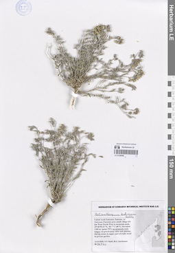
LE 01259598
Helianthemum kahiricum Delile det. Byalt, Vyacheslav Vyacheslavovich
Collectors: Byalt, Vyacheslav Vyacheslavovich; Korshunov, Mikhail Vladimirovich Field collecting number: 469bis. Collection date: 13.03.2020. Administrative regions: AE - United Arab Emirates. Place of collection: Fujairah Emirate, Al Tawyeen (Taween) area, small village 0.8 km West-North-West to mountain peak [point 707]: on mountain rock ledges.Groups of specimens: Образцы общего сектора; Соглашение Минобрнауки №075-15-2021-1056; Бялт В.В.: Флора ФуджейрыOriginal label text: UAE, Fujairah Emirate, Al Tawyeen (Taween) area, small village 0.8 km West-North-West to mountain peak. 25°38'59.41"N, 56° 7'17.88"E, elevation 1360 m. [point 707]: on mountain rock ledges, 13 III 2020, fr., V.V. Byalt, M.V. Korshunov 469 bis
LE 01259597
Helianthemum salicifolium (L.) Mill. det. Byalt, Vyacheslav Vyacheslavovich
Collectors: Byalt, Vyacheslav Vyacheslavovich; Korshunov, Mikhail Vladimirovich Field collecting number: 1020c. Collection date: 24.03.2020. Administrative regions: AE - United Arab Emirates. Place of collection: Fujairah Emirate, 0.6 km East-North-East to cell tower on the mountain peak, 3.5 km West to Ghub, 8 km West-South-West to Dibba [point 720]: on abandoned baghara (winter season dryland farm).Groups of specimens: Образцы общего сектора; Соглашение Минобрнауки №075-15-2021-1056; Бялт В.В.: Флора ФуджейрыOriginal label text: UAE, Fujairah emirate, 0.6 km East-North-East to cell tower on the mountain peak, 3.5 km West to Ghub, 8 km West-South-West to Dibba. 25°34'34.49"N, 56°10'6.31"E, elevation 730 m. [point 720]: on abandoned baghara (winter season dryland farm), 24 III 2020, fr., V.V. Byalt, M.V. Korshunov 1020c