View
Add
Copy
Edit
Delete
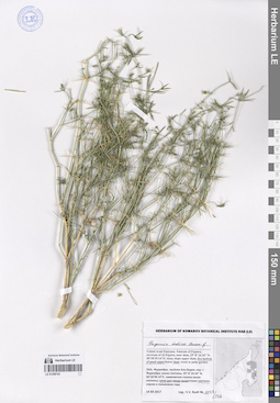
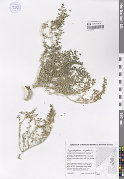
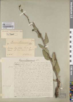
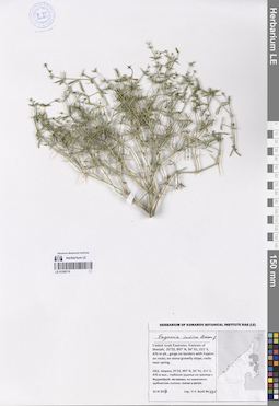
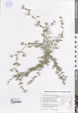
LE 01259725
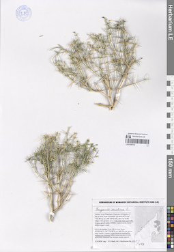
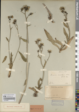
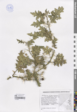
Fagonia indica Burm. f. det. Byalt, Vyacheslav Vyacheslavovich
Collectors: Byalt, Vyacheslav Vyacheslavovich Field collecting number: 1147/337. Collection date: 14.12.2017. Administrative regions: AE - United Arab Emirates. Place of collection: Фуджейра, пос. Аль Бидия, окрестности г. Фуджейра, около плотины, сухое дно пруда выше плотины.Groups of specimens: Образцы общего сектора; Соглашение Минобрнауки №075-15-2021-1056; Бялт В.В.: Флора ФуджейрыOriginal label text: United Arab Emirates. Emirate of Fujaira, environs of Al Fujeira, near dam, 25° 8' 24.34" N, 56°18'39.14"E: dry bottom of pond upper dam.– ОАЭ, Фуджейра, посёлок Аль Бидия, окр. г. Фуджейра, около плотины, 25° 8' 24.34" N, 56°18'39.14"E: сухое дно пруда выше плотины, 14 XII 2017, V.V. Byalt 1147/337
LE 01262700
Groups of specimens: Образцы сектора Кавказа; Типовые образцы сектора Кавказа; Соглашение Минобрнауки №075-15-2021-1056Record creation: 2023-11-22, Elena Portenier, PhotoScan D2.Citation: Specimen LE 01262700 // Virtual herbarium of Komarov Botanical Institute RAS — http://re.herbariumle.ru/01262700
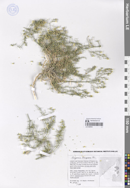
LE 01259724
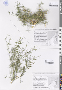
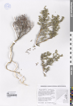
Fagonia bruguieri DC. det. Byalt, Vyacheslav Vyacheslavovich
Collectors: Byalt, Vyacheslav Vyacheslavovich; Korshunov, Vladimir Mikhailovich Field collecting number: 1149/288. Collection date: 31.03.2018. Administrative regions: AE - United Arab Emirates. Place of collection: эмират Фуджейра, окрестности пос. Дадна, западный край Вади Вурайя национального парка: каменистый и скалистый склон выше ущелья.Groups of specimens: Образцы общего сектора; Соглашение Минобрнауки №075-15-2021-1056; Бялт В.В.: Флора ФуджейрыOriginal label text: United Arab Emirates. Emirate of Fujaira, env. of Dhadna, 25°31'02.2"N 56°17'50.5"E, ca. 200-300 m alt., W edege of Wadi Wurayah national park: on stony and rocky slope upper gorge. – ОАЭ, эмират Фуджейра, окр. пос. Дадна, 25°31'02.2"N 56°17'50.5"E, ca. 200-300 м н. ур. м., W край Вади вурайя нац. парка: каменистый и скалистый склон выше ущелья, 31 III 2018, V.V. Byalt, V. Korshunov 1149/288
LE 01262699
Groups of specimens: Образцы сектора Кавказа; Типовые образцы сектора Кавказа; Соглашение Минобрнауки №075-15-2021-1056Record creation: 2023-11-22, Elena Portenier, PhotoScan D2.Citation: Specimen LE 01262699 // Virtual herbarium of Komarov Botanical Institute RAS — http://re.herbariumle.ru/01262699
LE 01262698
Groups of specimens: Образцы сектора Кавказа; Типовые образцы сектора Кавказа; Соглашение Минобрнауки №075-15-2021-1056Record creation: 2023-11-22, Elena Portenier, PhotoScan D2.Citation: Specimen LE 01262698 // Virtual herbarium of Komarov Botanical Institute RAS — http://re.herbariumle.ru/01262698
LE 01259723
Fagonia indica L. det. Byalt, Vyacheslav Vyacheslavovich
Collectors: Byalt, Vyacheslav Vyacheslavovich; Korshunov, Mikhail Vladimirovich Field collecting number: 1145/478. Collection date: 02.04.2018. Administrative regions: AE - United Arab Emirates. Place of collection: Фуджейра, 5 км северо-западнее Аль Хала, верх гряды с садом: сухие каменисто-щебнистые склоны.Groups of specimens: Образцы общего сектора; Соглашение Минобрнауки №075-15-2021-1056; Бялт В.В.: Флора ФуджейрыOriginal label text: United Arab Emirates. Emirate of Fujaira, 5 km to NW from Al Khala, 25°30'0.54"N 56° 7'52.40"E, ca. 300-350 m alt., the top of the ridge with garden: dry stony-gravelly slopes. – ОАЭ, Фуджейра, 5 км NW от Аль Хала, 25°30'0.54"N 56° 7'52.40"E, ca. 300-350 м н. ур. м., верх гряды с садом: сухие каменисто-щебнистые склоны, 2 IV 2018, V.V. Byalt, M.V. Korshunov 1145/478
LE 01262697
Groups of specimens: Образцы сектора Кавказа; Типовые образцы сектора Кавказа; Соглашение Минобрнауки №075-15-2021-1056Record creation: 2023-11-22, Elena Portenier, PhotoScan D2.Citation: Specimen LE 01262697 // Virtual herbarium of Komarov Botanical Institute RAS — http://re.herbariumle.ru/01262697
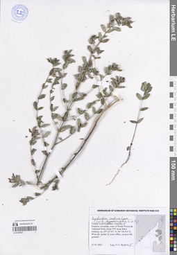
LE 01259722
Fagonia indica Burm. f. det. Byalt, Vyacheslav Vyacheslavovich
Additional identifications: Cuscuta planiflora Ten. det. Byalt, Vyacheslav Vyacheslavovich Collectors: Byalt, Vyacheslav Vyacheslavovich; Korshunov, Mikhail Vladimirovich Field collecting number: 1145/434. Collection date: 02.04.2018. Administrative regions: AE - United Arab Emirates. Place of collection: Фуджейра, 5 км северо-западнее Аль Хала, верх гряды с садом: сухие каменисто-щебнистые склоны, на Fagonia indica.Groups of specimens: Образцы общего сектора; Соглашение Минобрнауки №075-15-2021-1056; Бялт В.В.: Флора ФуджейрыOriginal label text: United Arab Emirates. Emirate of Fujaira, 5 km to NW from Al Khala, 25°30'0.54"N 56° 7'52.40"E, ca. 300-350 m alt., the top of the ridge with garden: dry stony-gravelly slopes, on Fagonia indica. – ОАЭ, Фуджейра, 5 км NW от Аль Хала, 25°30'0.54"N 56° 7'52.40"E, ca. 300-350 м н. ур. м., верх гряды с садом: сухие каменисто-щебнистые склоны, Fagonia indica, 2 IV 2018, V.V. Byalt, M.V. Korshunov 1145/434

LE 01259721
Fagonia indica Burm. f. det. Byalt, Vyacheslav Vyacheslavovich
Collectors: Byalt, Vyacheslav Vyacheslavovich; Korshunov, Mikhail Vladimirovich Field collecting number: 1146/123. Collection date: 27.03.2018. Administrative regions: AE - United Arab Emirates. Place of collection: эмират Фуджейра, шоссе Мазафи – Фуджейра, щебнисто-каменистая обочина шоссе.Groups of specimens: Образцы общего сектора; Соглашение Минобрнауки №075-15-2021-1056; Бялт В.В.: Флора ФуджейрыOriginal label text: United Arab Emirates. Emirate of Fujaira, Masafi – Fujaira road in env. of Fujaira, ca. 25°09'N 56°15'E: gravelly-stony roadside.– ОАЭ, эмират Фуджейра, шоссе Мазафи – Фуджейра, ca. 25°09'N 56°15'E, щебнисто-каменистая обочина, 27 III 2018, V.V. Byalt, M.V. Korshunov 1146/123
LE 01262696
Groups of specimens: Образцы сектора Кавказа; Типовые образцы сектора Кавказа; Соглашение Минобрнауки №075-15-2021-1056Record creation: 2023-11-22, Elena Portenier, PhotoScan D2.Citation: Specimen LE 01262696 // Virtual herbarium of Komarov Botanical Institute RAS — http://re.herbariumle.ru/01262696
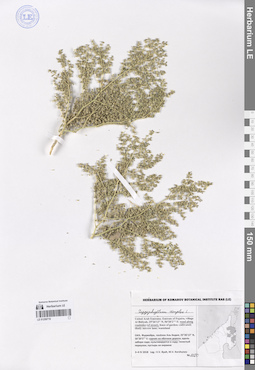
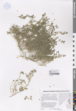
LE 01259720
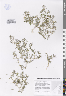
Zygophyllum simplex L. det. Byalt, Vyacheslav Vyacheslavovich
Collectors: Byalt, Vyacheslav Vyacheslavovich Field collecting number: 1155/335. Collection date: 14.12.2017. Administrative regions: AE - United Arab Emirates. Place of collection: Фуджейра, пос. Аль Бидия, окрестности г. Фуджейра, около плотины, сорное в пальмовом саду.Groups of specimens: Образцы общего сектора; Соглашение Минобрнауки №075-15-2021-1056; Бялт В.В.: Флора ФуджейрыOriginal label text: United Arab Emirates. Emirate of Fujaira, environs of Al Fujeira, near dam, 25° 8' 24.34" N, 56°18'39.14"E: weed in palm garden.– ОАЭ, Фуджейра, посёлок Аль Бидия, окр. г. Фуджейра, около плотины, 25° 8' 24.34" N, 56°18'39.14"E: сорняк в пальмовом саду, 14 XII 2017, V.V. Byalt 1155/335
LE 01262695
Groups of specimens: Образцы сектора Кавказа; Типовые образцы сектора Кавказа; Соглашение Минобрнауки №075-15-2021-1056Record creation: 2023-11-22, Elena Portenier, PhotoScan D2.Citation: Specimen LE 01262695 // Virtual herbarium of Komarov Botanical Institute RAS — http://re.herbariumle.ru/01262695
LE 01259719
Zygophyllum simplex L. det. Byalt, Vyacheslav Vyacheslavovich
Collectors: Byalt, Vyacheslav Vyacheslavovich; Korshunov, Mikhail Vladimirovich Field collecting number: 1150. Collection date: 04.04.2018. Administrative regions: AE - United Arab Emirates. Place of collection: Фуджейра, пос. Аль Бидия, сорное на обочине дороги.Groups of specimens: Образцы общего сектора; Соглашение Минобрнауки №075-15-2021-1056; Бялт В.В.: Флора ФуджейрыOriginal label text: United Arab Emirates. Emirate of Fujaira, village Al Bidiyah, 25°26'13" N, 56°20'2"° Е: weed along roadsides (of street). – ОАЭ, Фуджейра, посёлок Аль Бидия, 25°26'13" N, 56°20'2"° Е: сорняк на обочине дороги, 3–4 IV 2018, V.V. Byalt, M.V. Korshunov 1150
LE 01262694
Groups of specimens: Образцы сектора Кавказа; Типовые образцы сектора Кавказа; Соглашение Минобрнауки №075-15-2021-1056Record creation: 2023-11-22, Elena Portenier, PhotoScan D2.Citation: Specimen LE 01262694 // Virtual herbarium of Komarov Botanical Institute RAS — http://re.herbariumle.ru/01262694
LE 01259718
Seetzenia lanata (Willd.) Bullock det. Byalt, Vyacheslav Vyacheslavovich
Collectors: Byalt, Vyacheslav Vyacheslavovich; Korshunov, Mikhail Vladimirovich Field collecting number: 1154/628. Collection date: 04.04.2018. Administrative regions: AE - United Arab Emirates. Place of collection: Фуджейра, пос. Аль Бидия, пустырь на окраине.Groups of specimens: Образцы общего сектора; Соглашение Минобрнауки №075-15-2021-1056; Бялт В.В.: Флора ФуджейрыOriginal label text: United Arab Emirates. Emirate of Fujaira, village Al Bidiyah, 25°26'13" N, 56°20'2"° Е: in wasteland. – ОАЭ, Фуджейра, посёлок Аль Бидия, 25°26'13" N, 56°20'2"° Е: пустырь на окраине, 3–4 IV 2018, V.V. Byalt, M.V. Korshunov 1154/628
LE 01262693
Groups of specimens: Образцы сектора Кавказа; Типовые образцы сектора Кавказа; Соглашение Минобрнауки №075-15-2021-1056Record creation: 2023-11-22, Elena Portenier, PhotoScan D2.Citation: Specimen LE 01262693 // Virtual herbarium of Komarov Botanical Institute RAS — http://re.herbariumle.ru/01262693
LE 01259717
Zygophyllum simplex L. det. Byalt, Vyacheslav Vyacheslavovich
Collectors: Byalt, Vyacheslav Vyacheslavovich Field collecting number: 1156/319. Collection date: 14.12.2017. Administrative regions: AE - United Arab Emirates. Place of collection: Фуджейра, пос. Аль Бидия, окрестности г. Фуджейра, около плотины, сорное в пальмовом саду.Groups of specimens: Образцы общего сектора; Соглашение Минобрнауки №075-15-2021-1056; Бялт В.В.: Флора ФуджейрыOriginal label text: United Arab Emirates. Emirate of Fujaira, environs of Al Fujeira, near dam, 25° 8' 24.34" N, 56°18'39.14"E: weed in palm garden.– ОАЭ, Фуджейра, посёлок Аль Бидия, окр. г. Фуджейра, около плотины, 25° 8' 24.34" N, 56°18'39.14"E: сорняк в пальмовом саду, 14 XII 2017, V.V. Byalt 1156/319
LE 01262692
Groups of specimens: Образцы сектора Кавказа; Типовые образцы сектора Кавказа; Соглашение Минобрнауки №075-15-2021-1056Record creation: 2023-11-22, Elena Portenier, PhotoScan D2.Citation: Specimen LE 01262692 // Virtual herbarium of Komarov Botanical Institute RAS — http://re.herbariumle.ru/01262692
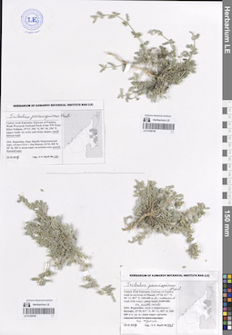
LE 01259716
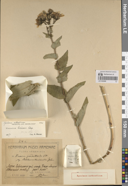
Fagonia ovalifolia Hadidi det. Byalt, Vyacheslav Vyacheslavovich
Collectors: Byalt, Vyacheslav Vyacheslavovich Field collecting number: 354. Collection date: 30.03.2017. Administrative regions: AE - United Arab Emirates. Place of collection: Фуджейра, окрестности г. Манама, барханы.Groups of specimens: Образцы общего сектора; Соглашение Минобрнауки №075-15-2021-1056; Бялт В.В.: Флора ФуджейрыOriginal label text: United Arab Emirates. Emirate of Fujaira, environs of Al Manama, 25°20,020’ N, 56° 11,847’ E: on the sandy dunes (barkhans). – ОАЭ, Фуджейра, окрестности г. Манама, 25°20,020’ N, 56° 11,847’ E: на барханах, 30 III 2017, V.V. Byalt 354
LE 01262691
Groups of specimens: Образцы сектора Кавказа; Типовые образцы сектора Кавказа; Соглашение Минобрнауки №075-15-2021-1056Record creation: 2023-11-22, Elena Portenier, PhotoScan D2.Citation: Specimen LE 01262691 // Virtual herbarium of Komarov Botanical Institute RAS — http://re.herbariumle.ru/01262691
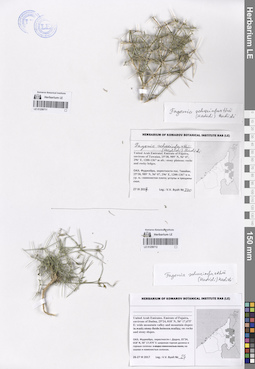
LE 01259715
Zygophyllum simplex L. det. Byalt, Vyacheslav Vyacheslavovich
Collectors: Byalt, Vyacheslav Vyacheslavovich; Korshunov, Mikhail Vladimirovich Field collecting number: 1153/409. Collection date: 02.04.2018. Administrative regions: AE - United Arab Emirates. Place of collection: Фуджейра, г. Дибба, берег Оманского залива: засоленный и песчаный пляж.Groups of specimens: Образцы общего сектора; Соглашение Минобрнауки №075-15-2021-1056; Бялт В.В.: Флора ФуджейрыOriginal label text: United Arab Emirates. Emirate of Fujaira, Dibba, 25°36'10.8"N 56°19'40.8"E, 2-10 m alt., beach of Oman gulf: saline and sandy soil of beach.– ОАЭ, Фуджей25°36'10.8"N 56°19'40.8"E 25°34'18.0"N 56°09'27.9"E, 2-10 м н. ур. м., берег Оманского залива: засоленный и песчаный пляж, 2 IV 2018, V.V. Byalt, M.V. Korshunov 1153/409
LE 01262690
Groups of specimens: Образцы сектора Кавказа; Типовые образцы сектора Кавказа; Соглашение Минобрнауки №075-15-2021-1056Record creation: 2023-11-22, Elena Portenier, PhotoScan D2.Citation: Specimen LE 01262690 // Virtual herbarium of Komarov Botanical Institute RAS — http://re.herbariumle.ru/01262690
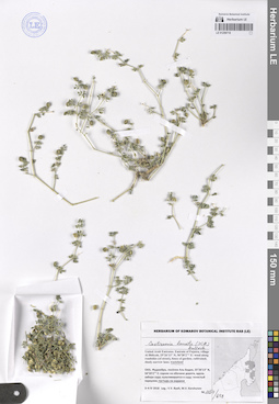
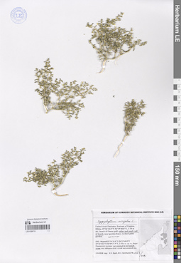
LE 01259714
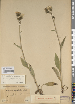
Zygophyllum qatarense Hadidi det. Byalt, Vyacheslav Vyacheslavovich
Collectors: Byalt, Vyacheslav Vyacheslavovich Field collecting number: 1151/317. Collection date: 05.04.2018. Administrative regions: AE - United Arab Emirates. Place of collection: Рас-ал-Хайма, Персидский залив, о. Сарайя, северная часть г. Рас-аль-Хайма, на дюнах.Groups of specimens: Образцы общего сектора; Соглашение Минобрнауки №075-15-2021-1056; Бялт В.В.: Флора ФуджейрыOriginal label text: United Arab Emirates. Emirate of Ras al Khaimah, Persian gulf, Sarayah island, N of Ras al Khaimah, 25°50'11.8"N 55°58'55.6"E, 0–5 m alt.: dunes.– ОАЭ, Рас ал Хайма, Персидский залив, о. Сарайя, Сев. часть г. Рас аль Хайма, 25°50'11.8"N 55°58'55.6"E, 0–5 м н.ур.м.: на дюнах, 30 III 2018, fr., V.V. Byalt 1151/317
LE 01262689
Groups of specimens: Образцы сектора Кавказа; Типовые образцы сектора Кавказа; Соглашение Минобрнауки №075-15-2021-1056Record creation: 2023-11-22, Elena Portenier, PhotoScan D2.Citation: Specimen LE 01262689 // Virtual herbarium of Komarov Botanical Institute RAS — http://re.herbariumle.ru/01262689
LE 01259713
Zygophyllum simplex L. det. Byalt, Vyacheslav Vyacheslavovich
Collectors: Byalt, Vyacheslav Vyacheslavovich Field collecting number: 218. Collection date: 26.03.2017. Administrative regions: AE - United Arab Emirates. Place of collection: Фуджейра, окрестности г. Дадна, высокий берег моря.Groups of specimens: Образцы общего сектора; Соглашение Минобрнауки №075-15-2021-1056; Бялт В.В.: Флора ФуджейрыOriginal label text: United Arab Emirates. Emirate of Fujaira, environs of Dadna, ca. 25°24’ N, 56° 17’ E, 5 m alt.: see shore. – ОАЭ, Фуджейра, окрестности г. Дадна, 25°24’ N, 56° 17’ E, 5 м н.ур.м.: высокий берег моря, 26 III 2017, V.V. Byalt 218
LE 01262688
Groups of specimens: Образцы сектора Кавказа; Типовые образцы сектора Кавказа; Соглашение Минобрнауки №075-15-2021-1056Record creation: 2023-11-22, Elena Portenier, PhotoScan D2.Citation: Specimen LE 01262688 // Virtual herbarium of Komarov Botanical Institute RAS — http://re.herbariumle.ru/01262688
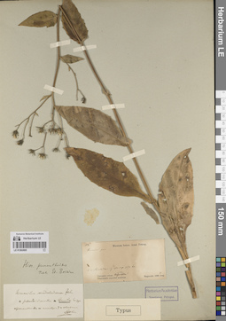
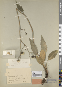
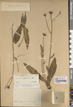
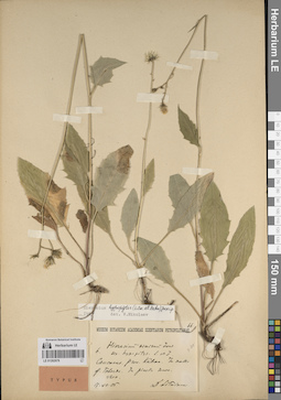
LE 01259711
Fagonia schweinfurthii (Hadidi) Hadidi ex Ghafoor det. Byalt, Vyacheslav Vyacheslavovich
Collectors: Byalt, Vyacheslav Vyacheslavovich Field collecting number: 370. Collection date: 27.03.2017. Administrative regions: AE - United Arab Emirates. Place of collection: Фуджейра, окрестности пос. Тавайан, каменистое плато; уступы и трещины скал.Groups of specimens: Образцы общего сектора; Соглашение Минобрнауки №075-15-2021-1056; Бялт В.В.: Флора ФуджейрыOriginal label text: United Arab Emirates. Emirate of Fujaira, environs of Tawaian, 25°38, 989’ N, 56° 07, 296’ E, 1200-1367 m alt.: stony plateau; rocks and rocky ledges. – ОАЭ, Фуджейра, окрестности пос. Тавайан, 25°38, 989’ N, 56° 07, 296’ E, 1200-1367 м н. ур. м.: каменистое плото; уступы и трещины скал, 27 III 2017, V.V. Byalt 370

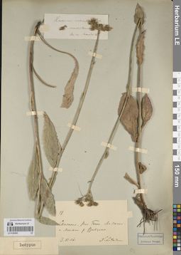
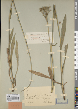
LE 01259712
Fagonia schweinfurthii (Hadidi) Hadidi ex Ghafoor det. Byalt, Vyacheslav Vyacheslavovich
Collectors: Byalt, Vyacheslav Vyacheslavovich Field collecting number: 24. Collection date: 26.03.2017. Administrative regions: AE - United Arab Emirates. Place of collection: Фуджейра, окрестности г. Дадна, широкая горная долина и горные склоны: на скалах и каменистых склонах.Groups of specimens: Образцы общего сектора; Соглашение Минобрнауки №075-15-2021-1056; Бялт В.В.: Флора ФуджейрыOriginal label text: United Arab Emirates. Emirate of Fujaira, environs of Dadna, 25°24, 018’ N, 56° 17,475’ E: wide mountain valley and mountain slopes: on rocks and stony slopes. – ОАЭ, Фуджейра, окрестности г. Дадна, 25°24, 018’ N, 56° 17,475’ E: широкая горная долина и горные склоны: на скалах и каменистых склонах, 26-27 III 2017, fl. juv., V.V. Byalt 24
LE 01262687
Groups of specimens: Образцы сектора Кавказа; Типовые образцы сектора Кавказа; Соглашение Минобрнауки №075-15-2021-1056Record creation: 2023-11-22, Elena Portenier, PhotoScan D2.Citation: Specimen LE 01262687 // Virtual herbarium of Komarov Botanical Institute RAS — http://re.herbariumle.ru/01262687
LE 01262686
Groups of specimens: Образцы сектора Кавказа; Типовые образцы сектора Кавказа; Соглашение Минобрнауки №075-15-2021-1056Record creation: 2023-11-22, Elena Portenier, PhotoScan D2.Citation: Specimen LE 01262686 // Virtual herbarium of Komarov Botanical Institute RAS — http://re.herbariumle.ru/01262686
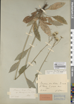
LE 01259710
Fagonia indica Burm. f. det. Byalt, Vyacheslav Vyacheslavovich
Collectors: Byalt, Vyacheslav Vyacheslavovich Field collecting number: 498. Collection date: 31.03.2017. Administrative regions: AE - United Arab Emirates. Place of collection: Шаржа, глубокое ущелье на границе с Фуджейрой: каменисто-щебнистый склон.Groups of specimens: Образцы общего сектора; Соглашение Минобрнауки №075-15-2021-1056; Бялт В.В.: Флора ФуджейрыOriginal label text: United Arab Emirates. Emirate of Sharjah, 25°22, 997’ N, 56° 01, 211’ E, 470 m alt., gorge on borders with Fujaira: on stony-gravelly slope.– ОАЭ, Шаржа, 25°22, 997’ N, 56° 01, 211’ E, 470 м выс., глубокое ущелье на границе с Фуджейрой: на каменисто-щебнистом склоне, 31 III 2017, fl., V.V. Byalt 498
LE 01262685
Groups of specimens: Образцы сектора Кавказа; Типовые образцы сектора Кавказа; Соглашение Минобрнауки №075-15-2021-1056Record creation: 2023-11-22, Elena Portenier, PhotoScan D2.Citation: Specimen LE 01262685 // Virtual herbarium of Komarov Botanical Institute RAS — http://re.herbariumle.ru/01262685
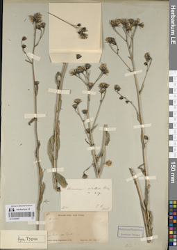
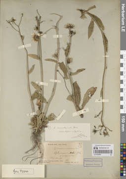
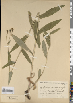
LE 01259708
Tribulus parvispinus C. Presl det. Byalt, Vyacheslav Vyacheslavovich
Collectors: Byalt, Vyacheslav Vyacheslavovich Field collecting number: 191. Collection date: 25.03.2017. Administrative regions: AE - United Arab Emirates. Place of collection: Фуджейра, Вади Вурайа Национальный парк, в 8 км северо-западнее г. Хор Факкан, выше вади: малый боковой вади.Groups of specimens: Образцы общего сектора; Соглашение Минобрнауки №075-15-2021-1056; Бялт В.В.: Флора ФуджейрыOriginal label text: United Arab Emirates. Emirate of Fujaira, Wadi Wurayah National Park, 8 km NW from Khor Fakkan, 25°23, 366’ N, 56° 18, 356’ E, upper wadi: in small lateral wadi.– ОАЭ, Фуджейра, Вади Вурайа Национальный парк, в 8 км к СЗ от г. Хор Факкан, 25°23, 366’ N, 56° 18, 356’ E, выше вади: малый боковой вади, 25 III 2017, fl., fr., V.V. Byalt 191

LE 01259709
Tribulus parvispinus C. Presl det. Byalt, Vyacheslav Vyacheslavovich
Collectors: Byalt, Vyacheslav Vyacheslavovich Field collecting number: 445. Collection date: 29.03.2017. Administrative regions: AE - United Arab Emirates. Place of collection: Фуджейра, вади в окрестности г. Мазафи, отрог вади с ручьем, на тропе.Groups of specimens: Образцы общего сектора; Соглашение Минобрнауки №075-15-2021-1056; Бялт В.В.: Флора ФуджейрыOriginal label text: United Arab Emirates. Emirate of Fujaira, wadi in environs of Masafi, 25°20, 017’ N, 56° 11, 847’ E, 540–600 m alt.: confluence of wadi with water, on pathside.– ОАЭ, Фуджейра, вади в окрестности г. Мазафи, 25°20, 017’ N, 56° 11, 847’ E, 540–600 м н. ур. м.: отрог вади с ручьем, на тропе, 29 III 2017, fl., fr., V.V. Byalt 445
LE 01262684
Groups of specimens: Образцы сектора Кавказа; Типовые образцы сектора Кавказа; Соглашение Минобрнауки №075-15-2021-1056Record creation: 2023-11-22, Elena Portenier, PhotoScan D2.Citation: Specimen LE 01262684 // Virtual herbarium of Komarov Botanical Institute RAS — http://re.herbariumle.ru/01262684
LE 01259707
Tribulus parvispinus C. Presl det. Byalt, Vyacheslav Vyacheslavovich
Collectors: Byalt, Vyacheslav Vyacheslavovich Field collecting number: 278. Collection date: 26.03.2017. Administrative regions: AE - United Arab Emirates. Place of collection: Фуджейра, окрестности г. Дадна, широкая горная долина и горные склоны: каменистые поля.Groups of specimens: Образцы общего сектора; Соглашение Минобрнауки №075-15-2021-1056; Бялт В.В.: Флора ФуджейрыOriginal label text: United Arab Emirates. Emirate of Fujaira, environs of Dadna, 25°24, 018’ N, 56° 17,475’ E: wide mountain valley and mountain slopes: on stony fields between wadies. – ОАЭ, Фуджейра, окрестности г. Дадна, 25°24, 018’ N, 56° 17,475’ E: широкая горная долина и горные склоны: каменистые поля, 26–27 III 2017, fl., fr., V.V. Byalt 278
LE 01262683
Groups of specimens: Образцы сектора Кавказа; Типовые образцы сектора Кавказа; Соглашение Минобрнауки №075-15-2021-1056Record creation: 2023-11-22, Elena Portenier, PhotoScan D2.Citation: Specimen LE 01262683 // Virtual herbarium of Komarov Botanical Institute RAS — http://re.herbariumle.ru/01262683
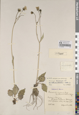
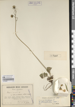
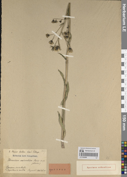
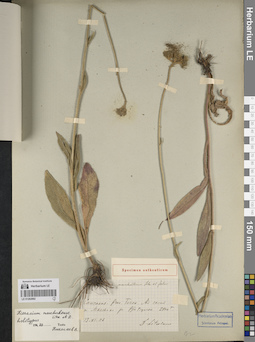
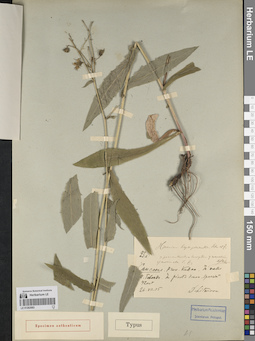
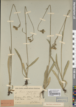
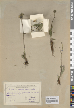
LE 01259706
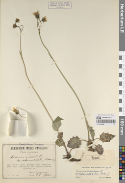
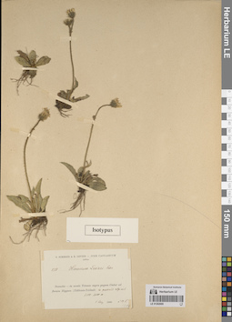
Viola cinerea Boiss. det. Byalt, Vyacheslav Vyacheslavovich
Collectors: Byalt, Vyacheslav Vyacheslavovich; Korshunov, Mikhail Vladimirovich Field collecting number: s.n. Collection date: 28.03.2020. Place of collection: Oman enclave Madha, 1 km to border with Fujairah Emirate, 6 km East from Nahwa (Sharjah Emirate), or 5 km North from Bitnah (Fujairah Emirate) [point 722]: on montain side.Groups of specimens: Образцы общего сектора; Соглашение Минобрнауки №075-15-2021-1056; Бялт В.В.: Флора ФуджейрыOriginal label text: Oman enclave Madha, 1 km to border with Fujairah Emirate, 6 km East from Nahwa (Sharjah Emirate), or 5 km North from Bitnah (Fujairah Emirate). 25°15'29.80"N, 56°13'32.22"E, elevation 455 m [point 722]: on montain side, 28 III 2020, V.V. Byalt, M.V. Korshunov s.n.
LE 01262682
Groups of specimens: Образцы сектора Кавказа; Типовые образцы сектора Кавказа; Соглашение Минобрнауки №075-15-2021-1056Record creation: 2023-11-22, Elena Portenier, PhotoScan D2.Citation: Specimen LE 01262682 // Virtual herbarium of Komarov Botanical Institute RAS — http://re.herbariumle.ru/01262682
LE 01259705
Euphorbia indica Lam. ⟮s. str.⟯ det. Byalt, Vyacheslav Vyacheslavovich
Additional identifications: Euphorbia hypericifolia L. ⟮s. l.⟯ det. Byalt, Vyacheslav Vyacheslavovich Collectors: Byalt, Vyacheslav Vyacheslavovich Field collecting number: 5. Collection date: 13.04.2022. Administrative regions: AE - United Arab Emirates. Place of collection: Emirate of Fujaira, carantine zone of Wadi Wurayah National Park, 8 km NW from Khor Fakkan, near office, on gravelly ground.Groups of specimens: Образцы общего сектора; Соглашение Минобрнауки №075-15-2021-1056; Бялт В.В.: Флора ФуджейрыOriginal label text: United Arab Emirates. Emirate of Fujaira, carantine zone of Wadi Wurayah National Park, 8 km NW from Khor Fakkan, ca. 25° 23.767' N, 56° 18.314' E, 90 m alt., near office, on gravelly ground, 13 IV 2022, fl., V.V. Byalt 5
LE 01262681
Groups of specimens: Образцы сектора Кавказа; Типовые образцы сектора Кавказа; Соглашение Минобрнауки №075-15-2021-1056Record creation: 2023-11-22, Elena Portenier, PhotoScan D2.Citation: Specimen LE 01262681 // Virtual herbarium of Komarov Botanical Institute RAS — http://re.herbariumle.ru/01262681
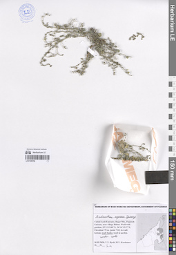
LE 01259704
Andrachne aspera Spreng. det. Byalt, Vyacheslav Vyacheslavovich
Collectors: Byalt, Vyacheslav Vyacheslavovich; Korshunov, Mikhail Vladimirovich Field collecting number: s.n. Collection date: 30.03.2020. Administrative regions: AE - United Arab Emirates. Place of collection: Fujairah Emirate, near village Bithna. Wadi with gardens [point 724]: wadi banks, under rock.Groups of specimens: Образцы общего сектора; Соглашение Минобрнауки №075-15-2021-1056; Herbarium of Wadi Wurayah Department, Goverment of FujairahOriginal label text: UAE, Fujairah Emirate, near village Bithna. Wadi with gardens. 25°11'19.00"N, 56°14'15.97"E, elevation 170 m. [point 724]: wadi banks, under rock, 30 III 2020, fl., fr., V.V. Byalt, M.V. Korshunov s.n.
LE 01262680
Groups of specimens: Образцы сектора Кавказа; Типовые образцы сектора Кавказа; Соглашение Минобрнауки №075-15-2021-1056Record creation: 2023-11-22, Elena Portenier, PhotoScan D2.Citation: Specimen LE 01262680 // Virtual herbarium of Komarov Botanical Institute RAS — http://re.herbariumle.ru/01262680
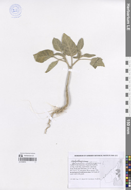
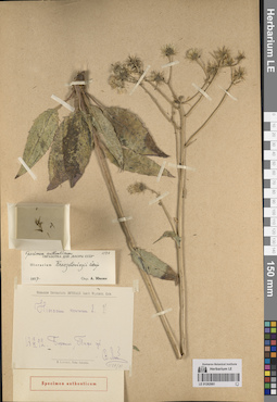
LE 01259703
Solanum melongena L. det. Byalt, Vyacheslav Vyacheslavovich
Additional identifications: Heliotropium sp. det. Byalt, Vyacheslav Vyacheslavovich Collectors: Byalt, Vyacheslav Vyacheslavovich; Korshunov, Mikhail Vladimirovich Field collecting number: s.n. Collection date: 01.04.2020. Administrative regions: AE - United Arab Emirates. Place of collection: Fujairah Emirate, Al Siji, wadi Siji, road-damb 1 km East from Wadi Siji Old Dam [point 729]: left bank of sand wadi with pond.Groups of specimens: Образцы общего сектора; Соглашение Минобрнауки №075-15-2021-1056; Бялт В.В.: Флора ФуджейрыOriginal label text: UAE, Fujairah Emirate, Al Siji, wadi Siji, road-damb 1 km East from Wadi Siji Old Dam, 25°15'7.86"N, 56° 5'15.17"E, elevation 286 m. [point 729]: left bank of sand wadi with pond, 1 IV 2020, veg., V.V. Byalt, M.V. Korshunov s.n.
LE 01262679
Groups of specimens: Образцы сектора Кавказа; Типовые образцы сектора Кавказа; Соглашение Минобрнауки №075-15-2021-1056Record creation: 2023-11-22, Elena Portenier, PhotoScan D2.Citation: Specimen LE 01262679 // Virtual herbarium of Komarov Botanical Institute RAS — http://re.herbariumle.ru/01262679
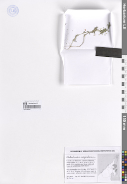
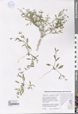
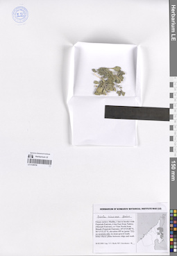
LE 01259702
Oldenlandia corymbosa L. det. Byalt, Vyacheslav Vyacheslavovich
Collectors: Byalt, Vyacheslav Vyacheslavovich; Korshunov, Mikhail Vladimirovich Field collecting number: s.n. Collection date: 25.11.2019. Administrative regions: AE - United Arab Emirates. Place of collection: Фуджейра, пос. Кидфа [point 343]: обочина дороги вдоль заборов в переулке.Groups of specimens: Образцы общего сектора; Соглашение Минобрнауки №075-15-2021-1056; Бялт В.В.: Флора ФуджейрыOriginal label text: United Arab Emirates. Emirate of Fujaira, village Qidfa, 25°17'40.91"N 56°21'28.51"E [point 343]: roadside along fence in backstreet. – ОАЭ, Фуджейра, пос. Кидфа, 25°17'40.91"N 56°21'28.51"E [point 343]: обочина дороги вдоль заборов в переулке, 25 XI 2019 V.V. Byalt & M.V. Korshunov s. n.
LE 01262678
Groups of specimens: Образцы сектора Кавказа; Типовые образцы сектора Кавказа; Соглашение Минобрнауки №075-15-2021-1056Record creation: 2023-11-22, Elena Portenier, PhotoScan D2.Citation: Specimen LE 01262678 // Virtual herbarium of Komarov Botanical Institute RAS — http://re.herbariumle.ru/01262678
LE 01259701
Solanum virginianum L. det. Byalt, Vyacheslav Vyacheslavovich
Additional identifications: Solanum surattense Burm. f. det. Byalt, Vyacheslav Vyacheslavovich Collectors: Byalt, Vyacheslav Vyacheslavovich; Korshunov, Mikhail Vladimirovich Field collecting number: s.n. Collection date: 17.04.2020. Administrative regions: AE - United Arab Emirates. Place of collection: Fujairah Emirate, Rul Dhadna, villas and accommodations north from Mina road, on corner with E99 Rugaylat road [pont 755]: weed in dranaige.Groups of specimens: Образцы общего сектора; Соглашение Минобрнауки №075-15-2021-1056; Бялт В.В.: Флора ФуджейрыOriginal label text: United Arab Emirates. Fujairah Emirate, Rul Dhadna, villas and accommodations north from Mina road, on corner with E99 Rugaylat road. 25°31'16.29"N, 56°21'19.69"E, elevation 12 m [pont 755]: weed in dranaige, 17 IV 2020, V.V. Byalt, M.V. Korshunov s.n
LE 01262677
Groups of specimens: Образцы сектора Кавказа; Типовые образцы сектора Кавказа; Соглашение Минобрнауки №075-15-2021-1056Record creation: 2023-11-22, Elena Portenier, PhotoScan D2.Citation: Specimen LE 01262677 // Virtual herbarium of Komarov Botanical Institute RAS — http://re.herbariumle.ru/01262677
LE 01259700
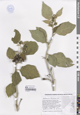
Solanum torvum Sw. det. Byalt, Vyacheslav Vyacheslavovich
Collectors: Byalt, Vyacheslav Vyacheslavovich; Korshunov, Mikhail Vladimirovich Field collecting number: 2216. Collection date: 17.04.2020. Administrative regions: AE - United Arab Emirates. Place of collection: Fujairah Emirate, Rul Dhadna, villas and accommodations north from Mina road, on corner with E99 Rugaylat road [pont 755]: cultivated near gates of villa.Groups of specimens: Образцы общего сектора; Соглашение Минобрнауки №075-15-2021-1056; Бялт В.В.: Флора ФуджейрыObject features: Fl. whiteOriginal label text: United Arab Emirates. Fujairah Emirate, Rul Dhadna, villas and accommodations north from Mina road, on corner with E99 Rugaylat road. 25°31'16.29"N, 56°21'19.69"E, Elevation 12 m [pont 755]: cultivated near gates of villa. h. fl. white., 17 IV 2020, fl., fr., V.V. Byalt, M.V. Korshunov 2216