View
Add
Copy
Edit
Delete
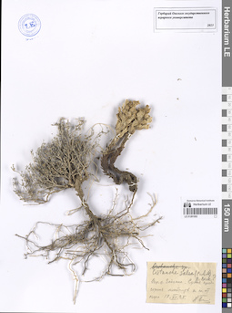
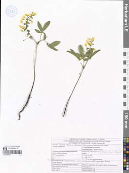
LE 01269178
Ziziphora pamiroalaica Juz. ⟮prelim. ID⟯ det. Melnikov, Denis Germanovich at 01.03.2024
Collectors: Busch Field collecting number: 258. Collection date: 18.08.1907. Administrative regions: UZ - Samarqand Viloyati. Топоним: кишлак Шахристан. Place of collection: у кишлака Шахристан.Groups of specimens: Образцы сектора Средней Азии; Соглашение Минобрнауки №075-15-2021-1056; Herbarium Horti botanici Imperialis Petri MagniOriginal label text:Самаркандская область на юго-восточных склонах гор у кишлака Шахристан
Landscape in location of collection: горыHabitat / plant community in location of collecting: на юго-восточных склонах горRecord creation: 2024-04-18, Denis Melnikov, PhotoScan D2.Citation: Specimen LE 01269178 // Virtual herbarium of Komarov Botanical Institute RAS — http://re.herbariumle.ru/01269178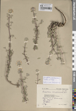
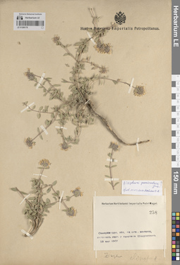
LE 01269177
Ziziphora vichodceviana Tkatsch. ex Tulyag. det. Melnikov, Denis Germanovich at 01.03.2024
Additional identifications: Ziziphora clinopodioides Lam. det. Emme, L. A. at 1929 Collectors: Emme, L. A. Field collecting number: 13. Collection date: 25.05.1929. Administrative regions: UZ - Samarqand Viloyati. Subregion: Туркестанский хребет. Топоним: река Джалаир. Place of collection: ущелье по реке Джалаир, 1200 метров над уровнем моря.Groups of specimens: Образцы сектора Средней Азии; Соглашение Минобрнауки №075-15-2021-1056; Л. А. Эмме. Растения Туркестана.Original label text:Туркестанский Хребет. Ущелье по реке Джалаир. На скалах. предгорья Высота 1200 метров
Landscape in location of collection: предгорьяHabitat / plant community in location of collecting: на скалахCoordinates (geographic position): 1200 m a.s.l.Record creation: 2024-04-18, Denis Melnikov, PhotoScan D2.Citation: Specimen LE 01269177 // Virtual herbarium of Komarov Botanical Institute RAS — http://re.herbariumle.ru/01269177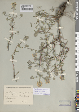
LE 01269176
Ziziphora vichodceviana Tkatsch. ex Tulyag. det. Melnikov, Denis Germanovich at 01.03.2024
Additional identifications: Ziziphora clinopodioides Lam. det. Berg, L. at 1906 Collectors: illegible Field collecting number: 114. Collection date: 11.06.1906. Administrative regions: UZ - Toshkent Viloyati - Yuqori Chirchiq Tumani. Топоним: населенный пункт Акбарак. Groups of specimens: Образцы сектора Средней Азии; Соглашение Минобрнауки №075-15-2021-1056; Herbarium Academiae Scientiarum Petropol.; Museum Botanicum Academiae Scientiarum PetropolitanaeOriginal label text:Самаркандская область ... уезд Акбарак
Landscape in location of collection: горыRecord creation: 2024-04-18, Denis Melnikov, PhotoScan D2.. Processing status: data is not fully enteredCitation: Specimen LE 01269176 // Virtual herbarium of Komarov Botanical Institute RAS — http://re.herbariumle.ru/01269176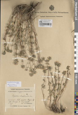
LE 01269175
Ziziphora brevicalyx Juz. det. Melnikov, Denis Germanovich at 01.03.2024
Additional identifications: Ziziphora clinopodioides Lam. det. Michelson, Alexander Ivanovich at 1914 Collectors: Michelson, Alexander Ivanovich Collection date: 01.07.1914. Administrative regions: UZ - Jizzakh Province - Baxmal Tumani. Subregion: Туркестанский хребет. Place of collection: северный склон Туркестанского хребта из Усмата в Багмазар.Expedition: О. Э. фон Кнорринг: Экспедиция в Самаркандскую обл. 1914 г. // O. von Knorring. Iter ad prov. Samarkand. (1914)Groups of specimens: Образцы сектора Средней Азии; Соглашение Минобрнауки №075-15-2021-1056; Hortus Botanicus Imperialis Petropolitanus.; Гербарий Переселенческого УправленияOriginal label text:Джизакский уезд Северный склон Туркестанского хребта из Усмата в Багмазар.
Landscape in location of collection: горыRecord creation: 2024-04-18, Denis Melnikov, PhotoScan D2.Citation: Specimen LE 01269175 // Virtual herbarium of Komarov Botanical Institute RAS — http://re.herbariumle.ru/01269175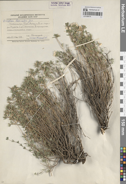
LE 01269174
Ziziphora brevicalyx Juz. det. Melnikov, Denis Germanovich at 01.03.2024
Collectors: Botschantzev, Victor Petrovič Field collecting number: 137. Collection date: 12.07.1970. Administrative regions: UZ - Navoiy Province - Nurota Tumani. Subregion: город Нурата. Топоним: сай Ингичке. Place of collection: к востоку от города Нурата, горы Актау.Groups of specimens: Образцы сектора Средней Азии; Соглашение Минобрнауки №075-15-2021-1056; Herbarium Instituti Botanici Academiae Scientiarum URSS. Leningrad.; Гербарий Ботанического Института Академии наук СССРOriginal label text:Узбекистан. Горы Актау к востоку от города Нурата. Сай Ингичке. В трещинах известняковых скал.
Landscape in location of collection: горыHabitat / plant community in location of collecting: в трещинах известняковых скалRecord creation: 2024-04-18, Denis Melnikov, PhotoScan D2.Citation: Specimen LE 01269174 // Virtual herbarium of Komarov Botanical Institute RAS — http://re.herbariumle.ru/01269174
LE 01269173
Ziziphora vichodceviana Tkatsch. ex Tulyag. det. Melnikov, Denis Germanovich at 01.03.2024
Additional identifications: Ziziphora clinopodioides Lam. det. Lazkov, Georgiy Anatol'evich; Laz'kov at 2013 Collectors: Botschantzev, Victor Petrovič Field collecting number: 142. Collection date: 15.10.1970. Administrative regions: UZ - Surxondaryo Viloyati - Sherobod Tumani. Топоним: хребет Кугитанг. Place of collection: окрестности кишлака Тангидувал.Groups of specimens: Образцы сектора Средней Азии; Соглашение Минобрнауки №075-15-2021-1056; Гербарий Ботанического Института Академии наук СССРOriginal label text:Узбекистан. Сурхандарьинская область Хребет Кугитанг. Окрестности кишлака Тангидувал. Каменистые склоны.
Landscape in location of collection: горыHabitat / plant community in location of collecting: каменистые склоныRecord creation: 2024-04-18, Denis Melnikov, PhotoScan D2.Citation: Specimen LE 01269173 // Virtual herbarium of Komarov Botanical Institute RAS — http://re.herbariumle.ru/01269173
LE 01269172
Ziziphora vichodceviana Tkatsch. ex Tulyag. det. Melnikov, Denis Germanovich at 01.03.2024
Additional identifications: Ziziphora clinopodioides Lam. det. Budogoski, A.D. at 1913 Collectors: Fedtschenko, Boris Alexeevich Field collecting number: 661. Collection date: 11.07.1913. Administrative regions: UZ - Jizzakh Province. Топоним: перевал Джиничке. Place of collection: отроги Малг-Гиссарских гор.Expedition: Исследование сорной растительности Туркестана, предпринятое Б. А. Федченко по поручению Департамента Земледелия ()Groups of specimens: Образцы сектора Средней Азии; Соглашение Минобрнауки №075-15-2021-1056; Hortus Botanicus Imperialis Petropolitanus.; А. Д. Будогоский: Растения Самаркандской области-1913Original label text:Джизакский уезд. Отроги Малг-Гизарских гор Вблизи перевала Джиничке.
Landscape in location of collection: горыRecord creation: 2024-04-18, Denis Melnikov, PhotoScan D2.Citation: Specimen LE 01269172 // Virtual herbarium of Komarov Botanical Institute RAS — http://re.herbariumle.ru/01269172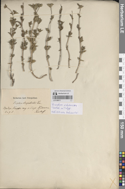
LE 01269171
Ziziphora vichodceviana Tkatsch. ex Tulyag. det. Melnikov, Denis Germanovich at 01.03.2024
Additional identifications: Ziziphora clinopodioides Lam. det. Sewerzov [Severtsov], Nikolai Alekseevich Collectors: Sewerzov [Severtsov], Nikolai Alekseevich Collection date: 09.05. Administrative regions: TJ - Viloyati Sughd - Khodzhentskiy Rayon. Топоним: предгорья Кхарлы-Тау. Groups of specimens: Образцы сектора Средней Азии; Соглашение Минобрнауки №075-15-2021-1056; Herbarium horti PetropolitaniOriginal label text:Предгорья Кхарлы-тау и близ Ходжента.
Landscape in location of collection: предгорьяRecord creation: 2024-04-18, Denis Melnikov, PhotoScan D2.Citation: Specimen LE 01269171 // Virtual herbarium of Komarov Botanical Institute RAS — http://re.herbariumle.ru/01269171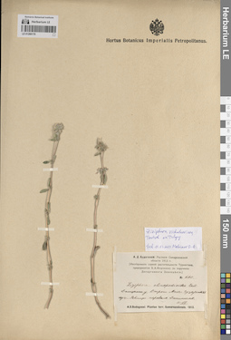
LE 01269170
Ziziphora vichodceviana Tkatsch. ex Tulyag. det. Melnikov, Denis Germanovich at 01.03.2024
Additional identifications: Ziziphora clinopodioides Lam. det. Budogoski, A.D. at 1913 Collectors: Fedtschenko, Boris Alexeevich Field collecting number: 660. Collection date: 11.07.1913. Administrative regions: UZ - Jizzakh Province. Топоним: перевал Джиничке. Place of collection: отроги Малг-Гиссарских гор.Expedition: Исследование сорной растительности Туркестана, предпринятое Б. А. Федченко по поручению Департамента Земледелия ()Groups of specimens: Образцы сектора Средней Азии; Соглашение Минобрнауки №075-15-2021-1056; Hortus Botanicus Imperialis Petropolitanus.; А. Д. Будогоский: Растения Самаркандской области-1913Original label text:Джизакский уезд. Отроги Малг-Гизарских гор Вблизи перевала Джиничке.
Landscape in location of collection: горыRecord creation: 2024-04-18, Denis Melnikov, PhotoScan D2.Citation: Specimen LE 01269170 // Virtual herbarium of Komarov Botanical Institute RAS — http://re.herbariumle.ru/01269170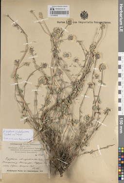
LE 01269169
Ziziphora vichodceviana Tkatsch. ex Tulyag. det. Melnikov, Denis Germanovich at 01.03.2024
Additional identifications: Ziziphora clinopodioides Lam. det. Budogoski, A.D. at 1913 Collectors: Fedtschenko, Boris Alexeevich Field collecting number: 678. Collection date: 12.07.1913. Administrative regions: UZ - Jizzakh Province. Топоним: овраг Аркауль-Сай. Place of collection: вблизи урочища Турук-Булак.Expedition: Исследование сорной растительности Туркестана, предпринятое Б. А. Федченко по поручению Департамента Земледелия ()Groups of specimens: Образцы сектора Средней Азии; Соглашение Минобрнауки №075-15-2021-1056; Hortus Botanicus Imperialis Petropolitanus.; А. Д. Будогоский: Растения Самаркандской области-1913Original label text:Джизакский уезд Вблизи урочища Турук-Булак. Овраг Аркауль-Сай
Landscape in location of collection: горыRecord creation: 2024-04-18, Denis Melnikov, PhotoScan D2.Citation: Specimen LE 01269169 // Virtual herbarium of Komarov Botanical Institute RAS — http://re.herbariumle.ru/01269169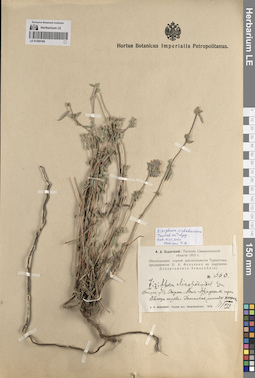
LE 01269168
Ziziphora vichodceviana Tkatsch. ex Tulyag. det. Melnikov, Denis Germanovich at 01.03.2024
Additional identifications: Ziziphora clinopodioides Lam. det. Budogoski, A.D. at 1913 Collectors: Fedtschenko, Boris Alexeevich Field collecting number: 660. Collection date: 11.07.1913. Administrative regions: UZ - Jizzakh Province. Топоним: перевал Джиничке. Place of collection: отроги Малг-Гиссарских гор.Expedition: Исследование сорной растительности Туркестана, предпринятое Б. А. Федченко по поручению Департамента Земледелия ()Groups of specimens: Образцы сектора Средней Азии; Соглашение Минобрнауки №075-15-2021-1056; Hortus Botanicus Imperialis Petropolitanus.; А. Д. Будогоский: Растения Самаркандской области-1913Original label text:Джизакский уезд. Отроги Малг-Гизарских гор Вблизи перевала Джиничке (между камнями)
Landscape in location of collection: горыHabitat / plant community in location of collecting: между камнямиRecord creation: 2024-04-18, Denis Melnikov, PhotoScan D2.Citation: Specimen LE 01269168 // Virtual herbarium of Komarov Botanical Institute RAS — http://re.herbariumle.ru/01269168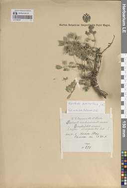
LE 01269167
Ziziphora pamiroalaica Juz. ⟮prelim. ID⟯ det. Melnikov, Denis Germanovich at 01.03.2024
Additional identifications: Ziziphora clinopodioides Lam. det. Sprygin, Ivan Ivanovich, Popov, Mikhail Grigorevich (Popow) at 1914 Collectors: Sprygin, Ivan Ivanovich; Popov, Mikhail Grigorevich (Popow) Field collecting number: 227. Collection date: 05.04.1914. Administrative regions: UZ - Samarqand Viloyati. Топоним: Когак-Тау. Groups of specimens: Образцы сектора Средней Азии; Соглашение Минобрнауки №075-15-2021-1056; И. И. Спрыгин и М. Г. Попов. Гербарий юго-восточной части Самаркандской области.; Hortus Botanicus Imperialis Petropolitanus.Original label text:Когак-Тау. Склоны на север-северо-запад.
Landscape in location of collection: горыHabitat / plant community in location of collecting: склоны на север-северо-западRecord creation: 2024-04-18, Denis Melnikov, PhotoScan D2.Citation: Specimen LE 01269167 // Virtual herbarium of Komarov Botanical Institute RAS — http://re.herbariumle.ru/01269167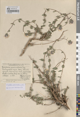
LE 01269166
Ziziphora pamiroalaica Juz. det. Melnikov, Denis Germanovich at 01.03.2024
Additional identifications: Ziziphora pamiroalaica Juz. det. Vassilczenko, Ivan Tikhonovich at 1958 Collectors: Vassilczenko, Ivan Tikhonovich; Sabirov B.; Ismatova Field collecting number: 238. Collection date: 18.08.1958. Administrative regions: UZ - Surxondaryo Viloyati - Boysun Tumani. Subregion: Байсунские горы. Place of collection: бассейны рек Мачай-Дарья, Иргайли-сай, 2450 метров над уровнем моря.Groups of specimens: Образцы сектора Средней Азии; Соглашение Минобрнауки №075-15-2021-1056; Гербарий Ботанического Института Академии наук СССРOriginal label text:Байсунские горы, бассейны рек Мачай-Дарья, Иргайли-сай, красноглинный обрыв с гипсом восточный склон, H - 2450 метров
Landscape in location of collection: горыHabitat / plant community in location of collecting: красноглинный обрыв с гипсомCoordinates (geographic position): 2450 m a.s.l.Record creation: 2024-04-18, Denis Melnikov, PhotoScan D2.Citation: Specimen LE 01269166 // Virtual herbarium of Komarov Botanical Institute RAS — http://re.herbariumle.ru/01269166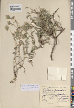
LE 01269165
Ziziphora pamiroalaica Juz. det. Melnikov, Denis Germanovich at 01.03.2024
Additional identifications: Ziziphora pamiroalaica Juz. det. Vassilczenko, Ivan Tikhonovich at 1958 Collectors: illegible; Sabirov B.; Ismatova Field collecting number: 295. Collection date: 19.08.1958. Administrative regions: UZ - Surxondaryo Viloyati - Boysun Tumani. Subregion: Байсунские горы. Топоним: река Иргайли-Сай. Place of collection: верховья реки Иргайли-сай, 2450 метров над уровнем моря.Groups of specimens: Образцы сектора Средней Азии; Соглашение Минобрнауки №075-15-2021-1056; Гербарий Ботанического Института Академии наук СССРOriginal label text:Байсунские горы, верховья реки Иргайли-сай, 2450 метров, гипсированный склон
Landscape in location of collection: горыHabitat / plant community in location of collecting: гипсированный склонCoordinates (geographic position): 2450 m a.s.l.Record creation: 2024-04-18, Denis Melnikov, PhotoScan D2.. Processing status: label contains unreadable dataCitation: Specimen LE 01269165 // Virtual herbarium of Komarov Botanical Institute RAS — http://re.herbariumle.ru/01269165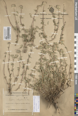
LE 01269164
Ziziphora pamiroalaica Juz. det. Melnikov, Denis Germanovich at 01.03.2024
Additional identifications: Ziziphora clinopodioides Lam. det. Knorring, Olga Evertovna at 1914 Collectors: Knorring, Olga Evertovna Field collecting number: 344. Collection date: 18.06.1914. Administrative regions: UZ - Samarqand Viloyati - Urgut Tumani. Топоним: перевал Тегана. Expedition: О. Э. фон Кнорринг: Экспедиция в Самаркандскую обл. 1914 г. // O. von Knorring. Iter ad prov. Samarkand. (1914)Groups of specimens: Образцы сектора Средней Азии; Соглашение Минобрнауки №075-15-2021-1056; Гербарий Переселенческого Управления; Hortus Botanicus Imperialis Petropolitanus.Original label text:Ходжентский уезд Спуск с перевала Тегана
Landscape in location of collection: горыRecord creation: 2024-04-18, Denis Melnikov, PhotoScan D2.Citation: Specimen LE 01269164 // Virtual herbarium of Komarov Botanical Institute RAS — http://re.herbariumle.ru/01269164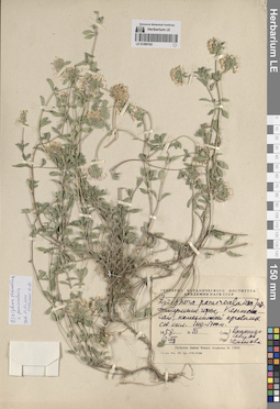
LE 01269163
Ziziphora pamiroalaica Juz. det. Melnikov, Denis Germanovich at 01.03.2024
Additional identifications: Ziziphora pamiroalaica Juz. det. Vassilczenko, Ivan Tikhonovich at 1958 Collectors: illegible; Sabirov B.; Ismatova Administrative regions: UZ - Surxondaryo Viloyati - Boysun Tumani. Subregion: Байсунские горы. Топоним: Кентек-Сай. Place of collection: 1600-1700 метров над уровнем моря.Groups of specimens: Образцы сектора Средней Азии; Соглашение Минобрнауки №075-15-2021-1056; Гербарий Ботанического Института Академии наук СССРOriginal label text:Байсунские горы, Кентек-сай, каменистый арчевник северный склон, 1600-1700 метров
Landscape in location of collection: горыHabitat / plant community in location of collecting: каменистый арчевник, северный склонCoordinates (geographic position): 1650 m a.s.l.Record creation: 2024-04-18, Denis Melnikov, PhotoScan D2.. Processing status: label contains unreadable dataCitation: Specimen LE 01269163 // Virtual herbarium of Komarov Botanical Institute RAS — http://re.herbariumle.ru/01269163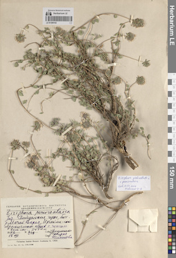
LE 01269162
Ziziphora vichodceviana Tkatsch. ex Tulyag. ⟨Ziziphora pedicellata x pamiroalaica⟩ det. Melnikov, Denis Germanovich at 01.03.2024
Additional identifications: Ziziphora pamiroalaica Juz. det. Vassilczenko, Ivan Tikhonovich at 1958 Collectors: illegible; Sabirov B.; Ismatova Field collecting number: 238. Collection date: 18.08.1958. Administrative regions: UZ - Surxondaryo Viloyati - Boysun Tumani. Subregion: Байсунские горы. Place of collection: бассейны рек Мачай-Дарья, Иргайли-Сай, 2450 метров над уровнем моря.Groups of specimens: Образцы сектора Средней Азии; Соглашение Минобрнауки №075-15-2021-1056; Гербарий Ботанического Института Академии наук СССРOriginal label text:Байсунские горы, бассейны рек Мачай-Дарья, Иргайли-сай Красноглинный обрыв с гипсом восточный склон, 2450 метров
Landscape in location of collection: горыHabitat / plant community in location of collecting: красноглинный обрыв с гипсом, восточный склонCoordinates (geographic position): 2450 m a.s.l.Record creation: 2024-04-18, Denis Melnikov, PhotoScan D2.. Processing status: label contains unreadable dataCitation: Specimen LE 01269162 // Virtual herbarium of Komarov Botanical Institute RAS — http://re.herbariumle.ru/01269162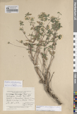
LE 01269161
Ziziphora pedicellata Pazij & Vved. det. Melnikov, Denis Germanovich at 01.03.2024
Additional identifications: Ziziphora brevicalyx Juz. det. Vassilczenko, Ivan Tikhonovich, Sabirov B. at 1955; Ziziphora pamiroalaica Juz. det. Lazkov, Georgiy Anatol'evich; Laz'kov at 2013 Collectors: Vassilczenko, Ivan Tikhonovich; Sabirov B. Field collecting number: 228. Collection date: 09.08.1955. Administrative regions: UZ - Surxondaryo Viloyati - Uzun Tumani. Subregion: кишлак Дуоба. Топоним: река Тупаланг. Place of collection: бассейн реки Тупаланг, 1700 метров над уровнем моря.Groups of specimens: Образцы сектора Средней Азии; Соглашение Минобрнауки №075-15-2021-1056; Гербарий Ботанического Института Академии наук СССРOriginal label text:Западный Гиссар Узбекская ССР. бассейн реки Тупаланг, выход в кишлак Дуоба к западу на восток 1700 метров
Landscape in location of collection: горыCoordinates (geographic position): 1700 m a.s.l.Record creation: 2024-04-18, Denis Melnikov, PhotoScan D2.Citation: Specimen LE 01269161 // Virtual herbarium of Komarov Botanical Institute RAS — http://re.herbariumle.ru/01269161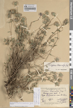
LE 01269160
Ziziphora vichodceviana Tkatsch. ex Tulyag. ⟨Ziziphora pedicellata x pamiroalaica⟩ det. Melnikov, Denis Germanovich at 01.03.2024
Additional identifications: Ziziphora brevicalyx Juz. det. Vassilczenko, Ivan Tikhonovich at 1958; Ziziphora pamiroalaica Juz. det. Lazkov, Georgiy Anatol'evich; Laz'kov at 2013 Collectors: illegible; illegible; Ismatova Field collecting number: 295а. Collection date: 19.08.1958. Administrative regions: UZ - Surxondaryo Viloyati - Boysun Tumani. Subregion: Байсунские горы. Топоним: река Иргайли-Сай. Place of collection: верховья реки Иргайли-Сай, 2450 метров над уровнем моря.Groups of specimens: Образцы сектора Средней Азии; Соглашение Минобрнауки №075-15-2021-1056; Гербарий Ботанического Института Академии наук СССРOriginal label text:Байсунские горы, - Верховья реки Иргайли-сай, 2450 метров
Landscape in location of collection: горыCoordinates (geographic position): 2450 m a.s.l.Record creation: 2024-04-18, Denis Melnikov, PhotoScan D2.. Processing status: label contains unreadable dataCitation: Specimen LE 01269160 // Virtual herbarium of Komarov Botanical Institute RAS — http://re.herbariumle.ru/01269160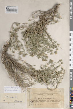
LE 01269159
Ziziphora brevicalyx Juz. det. Melnikov, Denis Germanovich at 01.03.2024
Additional identifications: Ziziphora clinopodioides Lam. det. Jarmolenko, Alexander Viktorovich at 1931; Ziziphora brevicalyx Juz. det. Juzepczuk, Sergei Vasilievich at 1954 Collectors: Jarmolenko, Alexander Viktorovich Field collecting number: 342. Collection date: 13.08.1931. Administrative regions: UZ - Surxondaryo Viloyati - Boysun Tumani. Subregion: поселок Сайроб. Топоним: ущелье Парч. Place of collection: подъем на Сузыз-Тау от поселка Сайроб, 1800 метров над уровнем моря.Expedition: А. В. Ярмоленко и И. А. Фирсв: Байсунская экспедиция ()Groups of specimens: Образцы сектора Средней Азии; Соглашение Минобрнауки №075-15-2021-1056; Гербарий Всесоюзного Научно-исследовательского института каучука и гуттаперчиOriginal label text:Узбекистан. Байсунский район. Под'ем на Сузыз-тау от поселка Сайроб. Ущелье Парч по расщелинам 1800 метров над уровнем моря
Landscape in location of collection: горыHabitat / plant community in location of collecting: по расщелинамCoordinates (geographic position): 1800 m a.s.l.Record creation: 2024-04-18, Denis Melnikov, PhotoScan D2.Citation: Specimen LE 01269159 // Virtual herbarium of Komarov Botanical Institute RAS — http://re.herbariumle.ru/01269159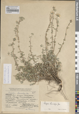
LE 01269158
Ziziphora brevicalyx Juz. det. Melnikov, Denis Germanovich at 01.03.2024
Additional identifications: Ziziphora brevicalyx Juz. det. Kamelin, Rudolph Vladimirovich at 1972 Collectors: Zaprjagaeva, Vera Ivanovna; Abdushakurova, S.; Ashurov; Kamelin, Rudolph Vladimirovich; Ershova, E.; Muratova; Plekhanov; Smeyan Field collecting number: 10081. Collection date: 30.07.1961. Administrative regions: UZ - Qashqadaryo Province - Dehqonobod Tumani; UZ - Surxondaryo Viloyati - Sherobod Tumani. Топоним: Гиссарский хребет. Place of collection: западные отроги Гиссарского хребта, между Дехканабадом и Ширабадом, 1150 метров над уровнем моря.Groups of specimens: Образцы сектора Средней Азии; Соглашение Минобрнауки №075-15-2021-1056; Гербарий Ботанического института Академии наук Таджикской ССРOriginal label text:Западные отроги Гиссарского хребта. Между Дехканабадом и Ширабадом. Каменистые склоны с красными песчаниками. H - 1150 метров. В зарослях шибляка.
Landscape in location of collection: горыHabitat / plant community in location of collecting: каменистые склоны с красными песчаниками, в зарослях шиблякаSubstrate in collecting location: red sandstoneCoordinates (geographic position): 1150 m a.s.l.Record creation: 2024-04-18, Denis Melnikov, PhotoScan D2.Citation: Specimen LE 01269158 // Virtual herbarium of Komarov Botanical Institute RAS — http://re.herbariumle.ru/01269158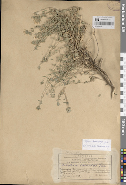
LE 01269157
Ziziphora brevicalyx Juz. det. Melnikov, Denis Germanovich at 01.03.2024
Additional identifications: Ziziphora brevicalyx Juz. det. Lazkov, Georgiy Anatol'evich; Laz'kov at 2013 Collectors: Jarmolenko, Alexander Viktorovich Field collecting number: 342. Collection date: 16.08.1931. Administrative regions: UZ - Surxondaryo Viloyati - Boysun Tumani. Subregion: поселок Сайроб. Топоним: ущелье Парч. Place of collection: подъем на Сузыз-Тау от поселка Сайроб, 1800 метров над уровнем моря.Expedition: А. В. Ярмоленко и И. А. Фирсв: Байсунская экспедиция ()Groups of specimens: Образцы сектора Средней Азии; Соглашение Минобрнауки №075-15-2021-1056; Гербарий Всесоюзного Научно-исследовательского института каучука и гуттаперчиOriginal label text:Узбекистан. Байсунский район. Под'ем на Сузыз-тау от поселка Сайроб. Ущелье Парч по расщелинам 1800 метров над уровнем моря
Landscape in location of collection: горыHabitat / plant community in location of collecting: по расщелинамCoordinates (geographic position): 1800 m a.s.l.Record creation: 2024-04-18, Denis Melnikov, PhotoScan D2.Citation: Specimen LE 01269157 // Virtual herbarium of Komarov Botanical Institute RAS — http://re.herbariumle.ru/01269157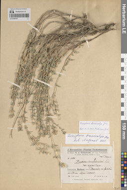
LE 01269156
Ziziphora brevicalyx Juz. det. Melnikov, Denis Germanovich at 01.03.2024
Additional identifications: Ziziphora clinopodioides var. rigida Boiss. det. Bornmüller, Joseph Friedrich Nicolaus at 1913; Ziziphora brevicalyx Juz. det. Lazkov, Georgiy Anatol'evich; Laz'kov at 2010 Collectors: Fedtschenko, Boris Alexeevich Field collecting number: 1130. Collection date: 21.08.1913. Administrative regions: UZ - Surxondaryo Viloyati - Boysun Tumani. Топоним: село Дарбанд (село Дербент). Place of collection: Гиссарский хребет, выше села Дарбанд.Groups of specimens: Образцы сектора Средней Азии; Соглашение Минобрнауки №075-15-2021-1056; J. Bornmüller: Plantae Turkestanicae in itinere B. A. Fedtschenko per reg. Samarkand et domin. Buchara lectae a. 1913Original label text:Dominium Buchara: provincium Baissun in faucibus in Hissar supra Derbent. 1200 m. s. m.
Landscape in location of collection: горыHabitat / plant community in location of collecting: в ущельяхCoordinates (geographic position): 1200 m a.s.l.Record creation: 2024-04-18, Denis Melnikov, PhotoScan D2.Citation: Specimen LE 01269156 // Virtual herbarium of Komarov Botanical Institute RAS — http://re.herbariumle.ru/01269156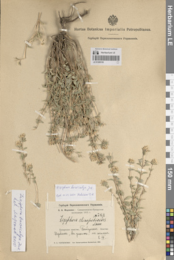
LE 01269155
Ziziphora brevicalyx Juz. det. Melnikov, Denis Germanovich at 01.03.2024
Additional identifications: Ziziphora clinopodioides Lam. det. Fedtschenko, Boris Alexeevich at 1913; Ziziphora brevicalyx Juz. det. Lazkov, Georgiy Anatol'evich; Laz'kov at 2010 Collectors: Fedtschenko, Boris Alexeevich Field collecting number: 761. Collection date: 08.08.1913. Administrative regions: UZ - Surxondaryo Viloyati - Boysun Tumani. Топоним: село Дарбанд (село Дербент). Expedition: Самаркандско-Бухарская экспедиция (1913)Groups of specimens: Образцы сектора Средней Азии; Соглашение Минобрнауки №075-15-2021-1056; Hortus Botanicus Imperialis Petropolitanus.; Гербарий Переселенческого УправленияOriginal label text:Бухарское ханство, Байсунское бекство Дербент, в ущелье, на скалах
Landscape in location of collection: горыHabitat / plant community in location of collecting: в ущелье, на скалахRecord creation: 2024-04-18, Denis Melnikov, PhotoScan D2.Citation: Specimen LE 01269155 // Virtual herbarium of Komarov Botanical Institute RAS — http://re.herbariumle.ru/01269155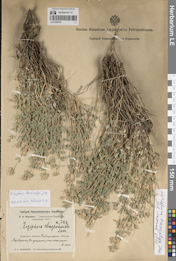
LE 01269154
Ziziphora brevicalyx Juz. det. Melnikov, Denis Germanovich at 01.03.2024
Additional identifications: Ziziphora clinopodioides Lam. det. Fedtschenko, Boris Alexeevich at 1913; Ziziphora brevicalyx Juz. det. Lazkov, Georgiy Anatol'evich; Laz'kov at 2010 Collectors: Fedtschenko, Boris Alexeevich Field collecting number: 761. Collection date: 08.08.1913. Administrative regions: UZ - Surxondaryo Viloyati - Boysun Tumani. Топоним: село Дарбанд (село Дербент). Expedition: Самаркандско-Бухарская экспедиция (1913)Groups of specimens: Образцы сектора Средней Азии; Соглашение Минобрнауки №075-15-2021-1056; Hortus Botanicus Imperialis Petropolitanus.; Гербарий Переселенческого УправленияOriginal label text:Бухарское ханство, Байсунское бекство Дербент, в ущелье, на скалах
Landscape in location of collection: горыHabitat / plant community in location of collecting: в ущелье, на скалахRecord creation: 2024-04-18, Denis Melnikov, PhotoScan D2.Citation: Specimen LE 01269154 // Virtual herbarium of Komarov Botanical Institute RAS — http://re.herbariumle.ru/01269154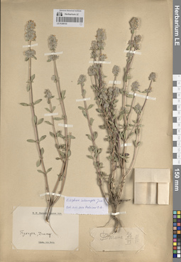
LE 01269153
Ziziphora interrupta Juz. det. Melnikov, Denis Germanovich at 01.03.2024
Collectors: Lipsky, Vladimir Ippolitovich Collection date: 23.06.1896. Administrative regions: UZ - Surxondaryo Viloyati - Denov Tumani. Топоним: Дагана. Groups of specimens: Образцы сектора Средней Азии; Соглашение Минобрнауки №075-15-2021-1056; В. И. Липский, Средняя АзияOriginal label text:Бухара, Денау.
Record creation: 2024-04-18, Denis Melnikov, PhotoScan D2.Citation: Specimen LE 01269153 // Virtual herbarium of Komarov Botanical Institute RAS — http://re.herbariumle.ru/01269153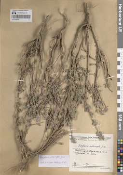
LE 01269152
Ziziphora interrupta Juz. det. Melnikov, Denis Germanovich at 01.03.2024
Additional identifications: Ziziphora interrupta Juz. det. Busch Collectors: Gontscharow, Nikolai Fedorovich Field collecting number: 47. Collection date: 22.08.1938. Administrative regions: UZ - Uzbekistan. Топоним: река Тупаланг. Place of collection: близ к. Шайтан.Groups of specimens: Образцы сектора Средней Азии; Соглашение Минобрнауки №075-15-2021-1056; Таджикистанская База Академии Наук СССР; Н. Ф. Гончаров. Растения Зап. Памиро-Алая.Original label text:Гиссарская долина. Галечник реки Тупаланга близ к. Шайтан. Высота 620 метров
Landscape in location of collection: горыHabitat / plant community in location of collecting: галечник рекиRecord creation: 2024-04-18, Denis Melnikov, PhotoScan D2.Citation: Specimen LE 01269152 // Virtual herbarium of Komarov Botanical Institute RAS — http://re.herbariumle.ru/01269152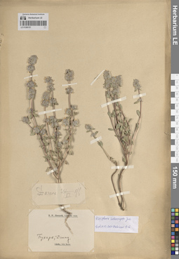
LE 01269151
Ziziphora interrupta Juz. det. Melnikov, Denis Germanovich at 01.03.2024
Collectors: Lipsky, Vladimir Ippolitovich Collection date: 25.06.1896. Administrative regions: UZ - Surxondaryo Viloyati - Denov Tumani. Топоним: Дагана. Groups of specimens: Образцы сектора Средней Азии; Соглашение Минобрнауки №075-15-2021-1056; В. И. Липский, Средняя АзияOriginal label text:Бухара, Денау.
Landscape in location of collection: горыRecord creation: 2024-04-18, Denis Melnikov, PhotoScan D2.Citation: Specimen LE 01269151 // Virtual herbarium of Komarov Botanical Institute RAS — http://re.herbariumle.ru/01269151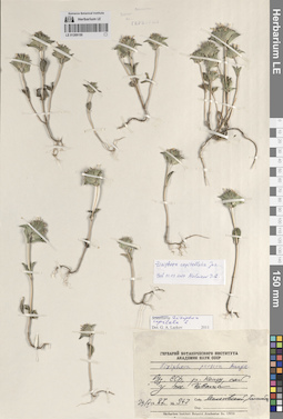
LE 01269150
Ziziphora capitellata Juz. det. Melnikov, Denis Germanovich at 01.03.2024
Additional identifications: Ziziphora persica Bunge det. Busch; Ziziphora capitata L. det. Lazkov, Georgiy Anatol'evich; Laz'kov at 2011 Collectors: Malakhovskiy; Gannibal, Boris Konstantinovich Field collecting number: 347. Collection date: 29.05.1987. Administrative regions: UZ - Uzbekistan. Топоним: река Кошу. Place of collection: у поселка Чаваша.Groups of specimens: Образцы сектора Средней Азии; Соглашение Минобрнауки №075-15-2021-1056; Гербарий Ботанического Института Академии наук СССРOriginal label text:Узбекская ССР, река Кошу, сай у поселка Чаваша.
Habitat / plant community in location of collecting: сай у поселкаRecord creation: 2024-04-18, Denis Melnikov, PhotoScan D2.Citation: Specimen LE 01269150 // Virtual herbarium of Komarov Botanical Institute RAS — http://re.herbariumle.ru/01269150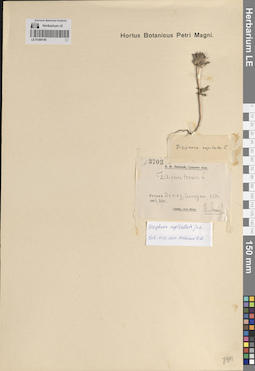
LE 01269149
Ziziphora capitellata Juz. det. Melnikov, Denis Germanovich at 01.03.2024
Additional identifications: Ziziphora tenuior L. det. Lipsky, Vladimir Ippolitovich at 1896; Ziziphora capitata L. det. Busch Collectors: Lipsky, Vladimir Ippolitovich Field collecting number: 3703. Collection date: 20.06.1896. Administrative regions: UZ - Surxondaryo Viloyati - Denov Tumani. Топоним: хребет Сангардак. Place of collection: 1350 метров над уровнем моря.Groups of specimens: Образцы сектора Средней Азии; Соглашение Минобрнауки №075-15-2021-1056; В. И. Липский, Средняя Азия; Hortus Botanicus Petri Magni.Original label text:Бухара. Денау, Сангардак, 4500'.
Landscape in location of collection: горыCoordinates (geographic position): 1350 m a.s.l.Record creation: 2024-04-18, Denis Melnikov, PhotoScan D2.Citation: Specimen LE 01269149 // Virtual herbarium of Komarov Botanical Institute RAS — http://re.herbariumle.ru/01269149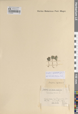
LE 01269148
Ziziphora capitellata Juz. det. Melnikov, Denis Germanovich at 01.03.2024
Additional identifications: Ziziphora tenuior L. det. Lipsky, Vladimir Ippolitovich at 1897; Ziziphora capitata L. det. Busch Collectors: Lipsky, Vladimir Ippolitovich Field collecting number: 3704. Collection date: 10.06.1897. Administrative regions: UZ - Bukhara Province. Топоним: река Тупаланг. Place of collection: хребет Малянь (Карва), 1650 метров над уровнем моря, верховья реки Тупаланг.Groups of specimens: Образцы сектора Средней Азии; Соглашение Минобрнауки №075-15-2021-1056; В. И. Липский, Средняя Азия; Hortus Botanicus Petri Magni.Original label text:Бухара. Гиссар, верхновья Тупаланга, Малянь (Карва), 5500'.
Landscape in location of collection: горыCoordinates (geographic position): 1650 m a.s.l.Record creation: 2024-04-18, Denis Melnikov, PhotoScan D2.Citation: Specimen LE 01269148 // Virtual herbarium of Komarov Botanical Institute RAS — http://re.herbariumle.ru/01269148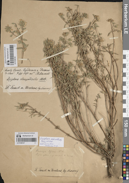
LE 01269147
Ziziphora pedicellata Pazij & Vved. det. Melnikov, Denis Germanovich at 01.03.2024
Collectors: Neuriskij Collection date: 27.06.1878. Administrative regions: UZ - Uzbekistan. Топоним: Кайнар, Кух-Уто. Groups of specimens: Образцы сектора Средней Азии; Соглашение Минобрнауки №075-15-2021-1056; Flora Turkestanica KorolkowObject features: употребляется в пищуOriginal label text:Кайнар Кух-уто - употребляется в пищу
Landscape in location of collection: горыRecord creation: 2024-04-18, Denis Melnikov, PhotoScan D2.Citation: Specimen LE 01269147 // Virtual herbarium of Komarov Botanical Institute RAS — http://re.herbariumle.ru/01269147
LE 01269146
Ziziphora pedicellata Pazij & Vved. det. Melnikov, Denis Germanovich at 01.03.2024
Collectors: Neuriskij Collection date: 06.08.1878. Place of collection: между Санк-Гарданом и Доганой, 900-1200 метров над уровнем моря.Groups of specimens: Образцы сектора Средней Азии; Соглашение Минобрнауки №075-15-2021-1056; Flora Turkestanica KorolkowOriginal label text:Между Санк-Гарданом и Доганой 3-4000'
Landscape in location of collection: горыCoordinates (geographic position): 1050 m a.s.l.Record creation: 2024-04-18, Denis Melnikov, PhotoScan D2.Citation: Specimen LE 01269146 // Virtual herbarium of Komarov Botanical Institute RAS — http://re.herbariumle.ru/01269146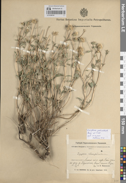
LE 01269145
Ziziphora pedicellata Pazij & Vved. det. Melnikov, Denis Germanovich at 01.03.2024
Additional identifications: Ziziphora clinopodioides Lam. det. Knorring, Olga Evertovna at 1914 Collectors: Michelson, Alexander Ivanovich Collection date: 15.07.1914. Administrative regions: UZ - Samarqand Viloyati. Топоним: Ухумский ручей, ущелье. Place of collection: хребет Кой-Зам, выше кишлака Ухум.Expedition: О. Э. фон Кнорринг: Экспедиция в Самаркандскую обл. 1914 г. // O. von Knorring. Iter ad prov. Samarkand. (1914)Groups of specimens: Образцы сектора Средней Азии; Соглашение Минобрнауки №075-15-2021-1056; Herbarium Horti botanici Imperialis Petropolitani; Гербарий Переселенческого УправленияOriginal label text:Джизакский уезд Каменистые склоны гор Кой-зам по ущелью ручья Ухумского, выше кишлака Ухум.
Landscape in location of collection: горыHabitat / plant community in location of collecting: каменистые склоны горRecord creation: 2024-04-18, Denis Melnikov, PhotoScan D2.Citation: Specimen LE 01269145 // Virtual herbarium of Komarov Botanical Institute RAS — http://re.herbariumle.ru/01269145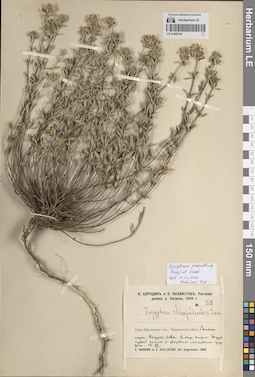
LE 01269144
Ziziphora pedicellata Pazij & Vved. det. Melnikov, Denis Germanovich at 01.03.2024
Additional identifications: Ziziphora clinopodioides Lam. det. Borodin, W., Kallistov (Kallistow) V. at 1909 Collectors: Borodin, W.; Kallistov (Kallistow) V. Field collecting number: 53. Collection date: 13.06.1909. Administrative regions: UZ - Toshkent Viloyati. Топоним: кишлак Турк. Place of collection: окрестности кишлака Турк, гора Хазрет-бова.Groups of specimens: Образцы сектора Средней Азии; Соглашение Минобрнауки №075-15-2021-1056; В. Бородин и В. Каллистов: Растения долины реки Ангрена-1909Original label text:Сыр-Дарьинская область Ташкентский уезд Склон горы Хазрет-бова в окрестностях кишлака Турк сухой склон с твердым лессовым грунтом.
Landscape in location of collection: горыHabitat / plant community in location of collecting: склон горыRecord creation: 2024-04-18, Denis Melnikov, PhotoScan D2.Citation: Specimen LE 01269144 // Virtual herbarium of Komarov Botanical Institute RAS — http://re.herbariumle.ru/01269144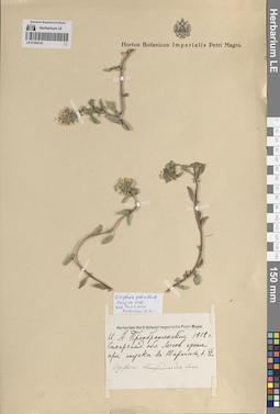
LE 01269143
Ziziphora pedicellata Pazij & Vved. det. Melnikov, Denis Germanovich at 01.03.2024
Additional identifications: Ziziphora clinopodioides Lam. det. Fedtschenko, Olga Alexandrowna, Fedtschenko, Boris Alexeevich Collectors: Preobrazhensky, I. A. Collection date: 06.1912. Administrative regions: UZ - Samarqand Viloyati. Топоним: Тарагай. Place of collection: при спуске к Тарагаю.Groups of specimens: Образцы сектора Средней Азии; Соглашение Минобрнауки №075-15-2021-1056; Herbarium Horti botanici Imperialis Petri Magni; Hortus Botanicus Imperialis Petri Magni.Original label text:Самаркандская область Лессовые степи при спуске к Тарагаю.
Landscape in location of collection: горыHabitat / plant community in location of collecting: лессовые степиRecord creation: 2024-04-18, Denis Melnikov, PhotoScan D2.Citation: Specimen LE 01269143 // Virtual herbarium of Komarov Botanical Institute RAS — http://re.herbariumle.ru/01269143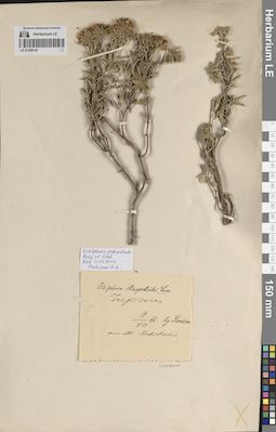
LE 01269142
Ziziphora pedicellata Pazij & Vved. det. Melnikov, Denis Germanovich at 01.03.2024
Additional identifications: Ziziphora clinopodioides Lam. det. Sewerzov [Severtsov], Nikolai Alekseevich at 1866 Collectors: Sewerzov [Severtsov], Nikolai Alekseevich Collection date: 09.07.1866. Administrative regions: UZ - Toshkent Viloyati. Топоним: город Чирчик. Place of collection: на реке Чирчик.Groups of specimens: Образцы сектора Средней Азии; Соглашение Минобрнауки №075-15-2021-1056Original label text:Чирчик
Landscape in location of collection: теплоумеренный аридный поясRecord creation: 2024-04-18, Denis Melnikov, PhotoScan D2.Citation: Specimen LE 01269142 // Virtual herbarium of Komarov Botanical Institute RAS — http://re.herbariumle.ru/01269142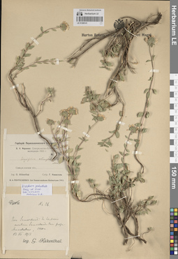
LE 01269141
Ziziphora pedicellata Pazij & Vved. det. Melnikov, Denis Germanovich at 01.03.2024
Additional identifications: Ziziphora clinopodioides Lam. det. Fedtschenko, Boris Alexeevich at 1913 Collectors: Kueckenthal, G. Collection date: 13.07.1913. Administrative regions: UZ - Samarqand Viloyati. Топоним: Амано-Кутан (Аман-Кутан). Place of collection: возле села Аман-Кутан, гора Самарканд-Тау.Groups of specimens: Образцы сектора Средней Азии; Соглашение Минобрнауки №075-15-2021-1056; Hortus Botanicus Imperialis Petri Magni.Original label text:Provincium Samarkand In herbosis montium Samarkand-tau prope Amankutan. 1400 m.
Landscape in location of collection: горыHabitat / plant community in location of collecting: травянистые сообществаCoordinates (geographic position): 0° 0′ 0″ N, 0° 0′ 0″ E 1400 m a.s.l.Record creation: 2024-04-18, Denis Melnikov, PhotoScan D2.Citation: Specimen LE 01269141 // Virtual herbarium of Komarov Botanical Institute RAS — http://re.herbariumle.ru/01269141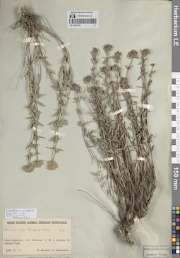
LE 01269140
Ziziphora pedicellata Pazij & Vved. det. Melnikov, Denis Germanovich at 01.03.2024
Collectors: Borodin, W.; Kallistov (Kallistow) V. Field collecting number: 53. Collection date: 13.06.1909. Administrative regions: UZ - Toshkent Viloyati. Топоним: река Ангрен. Place of collection: близ кишлака Турк, гора Хазрет-бова.Groups of specimens: Образцы сектора Средней Азии; Соглашение Минобрнауки №075-15-2021-1056; Museum Botanicum Academiae Scientiarum PetropolitanaeOriginal label text:Склон горы Хазрет-бова Сыр-Дарьинская область Ташкентский уезд По реке Ангрен, близ кишлака Турк.
Landscape in location of collection: горыHabitat / plant community in location of collecting: склон горыRecord creation: 2024-04-18, Denis Melnikov, PhotoScan D2.Citation: Specimen LE 01269140 // Virtual herbarium of Komarov Botanical Institute RAS — http://re.herbariumle.ru/01269140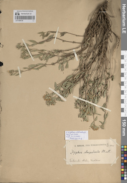
LE 01269139
Ziziphora pedicellata Pazij & Vved. det. Melnikov, Denis Germanovich at 01.03.2024
Additional identifications: Ziziphora clinopodioides Lam. det. Regel, (Johann) Albert von at 1880 Collectors: Regel, (Johann) Albert von Collection date: 16.06.1880. Administrative regions: UZ - Toshkent Viloyati. Топоним: гора Коштерек. Place of collection: хребет Ташкентский Алатау.Expedition: A. Regel. Iter Turkestanicum (1876 -1885)Groups of specimens: Образцы сектора Средней Азии; Соглашение Минобрнауки №075-15-2021-1056Original label text:Taschkenter Alatau, Koschterek
Landscape in location of collection: горыRecord creation: 2024-04-18, Denis Melnikov, PhotoScan D2.Citation: Specimen LE 01269139 // Virtual herbarium of Komarov Botanical Institute RAS — http://re.herbariumle.ru/01269139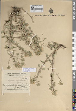
LE 01269138
Ziziphora pedicellata Pazij & Vved. det. Melnikov, Denis Germanovich at 01.03.2024
Additional identifications: Ziziphora clinopodioides Lam. det. Fedtschenko, Boris Alexeevich at 1913 Collectors: Kueckenthal, G. Field collecting number: 26. Collection date: 13.07.1913. Administrative regions: UZ - Samarqand Viloyati. Топоним: Амано-Кутан (Аман-Кутан). Place of collection: возле села Аман-Кутан, гора Самарканд-Тау.Expedition: Самаркандско-Бухарская экспедиция (1913)Groups of specimens: Образцы сектора Средней Азии; Соглашение Минобрнауки №075-15-2021-1056; Hortus Botanicus Imperialis Petri Magni.; Гербарий Переселенческого УправленияOriginal label text:Самаркандская область In herbosis montium Samarkand-tau prope Amankutan. 1400 m.
Landscape in location of collection: горыHabitat / plant community in location of collecting: травянистые сообществаCoordinates (geographic position): 1400 m a.s.l.Record creation: 2024-04-18, Denis Melnikov, PhotoScan D2.Citation: Specimen LE 01269138 // Virtual herbarium of Komarov Botanical Institute RAS — http://re.herbariumle.ru/01269138
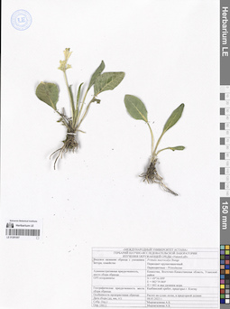
LE 01281010
Groups of specimens: Образцы сектора Средней Азии; Соглашение Минобрнауки №075-15-2021-1056Record creation: 2024-04-17, Mariya Sheludyakova, PhotoScan D2.Citation: Specimen LE 01281010 // Virtual herbarium of Komarov Botanical Institute RAS — http://re.herbariumle.ru/01281010
LE 01281009
Groups of specimens: Образцы сектора Средней Азии; Соглашение Минобрнауки №075-15-2021-1056Record creation: 2024-04-17, Mariya Sheludyakova, PhotoScan D2.Citation: Specimen LE 01281009 // Virtual herbarium of Komarov Botanical Institute RAS — http://re.herbariumle.ru/01281009
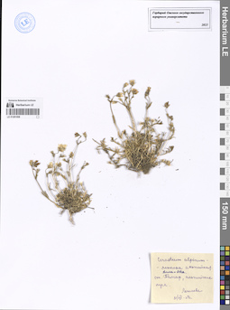
LE 01281008
Cerastium alpinum L.
Collection date: 31.07.1937. Administrative regions: KZ - Almaty Oblysy. Groups of specimens: Образцы сектора Средней Азии; Соглашение Минобрнауки №075-15-2021-1056Original label text:Cerastium alpinum L. - ясколка альпийская
Coordinates (geographic position): 43° 16′ 38.88″ N, 77° 15′ 3.88″ ERecord creation: 2024-04-17, Mariya Sheludyakova, PhotoScan D2.Citation: Specimen LE 01281008 // Virtual herbarium of Komarov Botanical Institute RAS — http://re.herbariumle.ru/01281008Алма-Ата
ст. Талгар, альпийские луга.
Лежнева
31 VII 1937
LE 01281007
Groups of specimens: Образцы сектора Средней Азии; Соглашение Минобрнауки №075-15-2021-1056Record creation: 2024-04-17, Mariya Sheludyakova, PhotoScan D2.Citation: Specimen LE 01281007 // Virtual herbarium of Komarov Botanical Institute RAS — http://re.herbariumle.ru/01281007
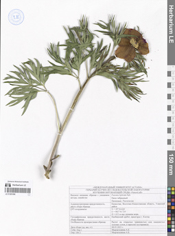
LE 01281006
Paeonia hybrida Pall.
Groups of specimens: Образцы сектора Средней Азии; Соглашение Минобрнауки №075-15-2021-1056Record creation: 2024-04-17, Mariya Sheludyakova, PhotoScan D2.Citation: Specimen LE 01281006 // Virtual herbarium of Komarov Botanical Institute RAS — http://re.herbariumle.ru/01281006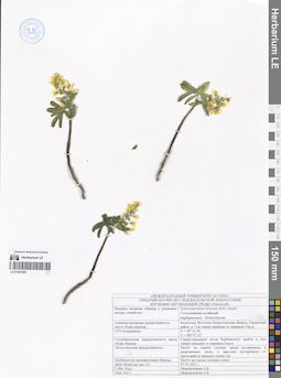
LE 01281005
Gymnospermium altaicum (Pall.) Spach
Groups of specimens: Образцы сектора Средней Азии; Соглашение Минобрнауки №075-15-2021-1056Record creation: 2024-04-17, Mariya Sheludyakova, PhotoScan D2.Citation: Specimen LE 01281005 // Virtual herbarium of Komarov Botanical Institute RAS — http://re.herbariumle.ru/01281005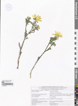
LE 01281004
Groups of specimens: Образцы сектора Средней Азии; Соглашение Минобрнауки №075-15-2021-1056Record creation: 2024-04-17, Mariya Sheludyakova, PhotoScan D2.Citation: Specimen LE 01281004 // Virtual herbarium of Komarov Botanical Institute RAS — http://re.herbariumle.ru/01281004
LE 01281003
Gymnospermium altaicum (Pall.) Spach
Groups of specimens: Образцы сектора Средней Азии; Соглашение Минобрнауки №075-15-2021-1056Record creation: 2024-04-17, Mariya Sheludyakova, PhotoScan D2.Citation: Specimen LE 01281003 // Virtual herbarium of Komarov Botanical Institute RAS — http://re.herbariumle.ru/01281003