View
Add
Copy
Edit
Delete
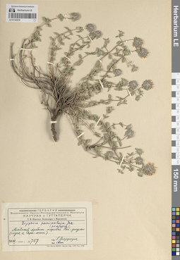
LE 01140578
Paratype of Ziziphora pamiroalaica Juz. det. Juzepczuk, Sergei Vasilievich
Collectors: Juzepczuk, Sergei Vasilievich Field collecting number: 757. Collection date: 20.07.1930. Administrative regions: KG - Kyrgyzstan. Топоним: перевал Кой-Джулы. Place of collection: Алайский хребет, спуск к горе Сарыташ.Expedition: С. В. Юзепчук. Экспедиция в Киргизстан. ()Groups of specimens: Образцы сектора Средней Азии; Соглашение Минобрнауки №075-15-2021-1056; Типовые образцы сектора Средней Азии; Гербарий Всесоюзного Научно-исследовательского института каучука и гуттаперчиOriginal label text:Алайский хребет: перевал Кой-джулы (спуск к Сары-таш).
Landscape in location of collection: перевал в горахRecord creation: 2024-04-18, Denis Melnikov, PhotoScan D2.Citation: Specimen LE 01140578 // Virtual herbarium of Komarov Botanical Institute RAS — http://re.herbariumle.ru/01140578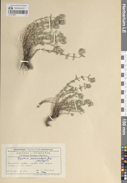
LE 01140577
Paratype of Ziziphora pamiroalaica Juz. det. Juzepczuk, Sergei Vasilievich
Collectors: Juzepczuk, Sergei Vasilievich Field collecting number: 757. Collection date: 20.07.1930. Administrative regions: KG - Kyrgyzstan. Топоним: перевал Кой-Джулы. Place of collection: Алайский хребет, спуск к горе Сарыташ.Expedition: С. В. Юзепчук. Экспедиция в Киргизстан. ()Groups of specimens: Образцы сектора Средней Азии; Соглашение Минобрнауки №075-15-2021-1056; Типовые образцы сектора Средней Азии; Гербарий Всесоюзного Научно-исследовательского института каучука и гуттаперчиOriginal label text:Алайский хребет: перевал Кой-джулы (спуск к Сары-таш).
Landscape in location of collection: перевал в горахRecord creation: 2024-04-18, Denis Melnikov, PhotoScan D2.Citation: Specimen LE 01140577 // Virtual herbarium of Komarov Botanical Institute RAS — http://re.herbariumle.ru/01140577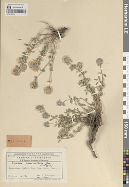
LE 01140576
Isotype of Ziziphora pamiroalaica Juz. det. Juzepczuk, Sergei Vasilievich
Collectors: Juzepczuk, Sergei Vasilievich Field collecting number: 874. Collection date: 22.07.1930. Administrative regions: KG - Kyrgyzstan. Топоним: гора Сарыташ. Place of collection: Алайский хребет.Expedition: С. В. Юзепчук. Экспедиция в Киргизстан. ()Groups of specimens: Образцы сектора Средней Азии; Соглашение Минобрнауки №075-15-2021-1056; Типовые образцы сектора Средней Азии; Гербарий Всесоюзного Научно-исследовательского института каучука и гуттаперчиOriginal label text:Алайский хребет: Сары-таш, склон горы
Landscape in location of collection: горыHabitat / plant community in location of collecting: склон горыRecord creation: 2024-04-18, Denis Melnikov, PhotoScan D2.Citation: Specimen LE 01140576 // Virtual herbarium of Komarov Botanical Institute RAS — http://re.herbariumle.ru/01140576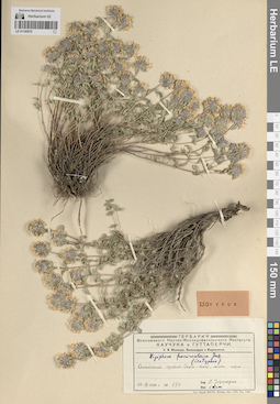
LE 01140575
Isotype of Ziziphora pamiroalaica Juz. det. Juzepczuk, Sergei Vasilievich
Collectors: Juzepczuk, Sergei Vasilievich Field collecting number: 874. Collection date: 22.07.1930. Administrative regions: KG - Kyrgyzstan. Топоним: гора Сарыташ. Place of collection: Алайский хребет.Expedition: С. В. Юзепчук. Экспедиция в Киргизстан. ()Groups of specimens: Образцы сектора Средней Азии; Соглашение Минобрнауки №075-15-2021-1056; Типовые образцы сектора Средней Азии; Гербарий Всесоюзного Научно-исследовательского института каучука и гуттаперчиOriginal label text:Алайский хребет: Сары-таш, склон горы
Landscape in location of collection: горыHabitat / plant community in location of collecting: склон горыRecord creation: 2024-04-18, Denis Melnikov, PhotoScan D2.Citation: Specimen LE 01140575 // Virtual herbarium of Komarov Botanical Institute RAS — http://re.herbariumle.ru/01140575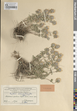
LE 01140574
Holotype of Ziziphora pamiroalaica Juz. det. Juzepczuk, Sergei Vasilievich
Collectors: Juzepczuk, Sergei Vasilievich Field collecting number: 874. Collection date: 22.07.1930. Administrative regions: KG - Kyrgyzstan. Топоним: гора Сарыташ. Place of collection: Алайский хребет.Expedition: С. В. Юзепчук. Экспедиция в Киргизстан. ()Groups of specimens: Образцы сектора Средней Азии; Соглашение Минобрнауки №075-15-2021-1056; Типовые образцы сектора Средней Азии; Гербарий Всесоюзного Научно-исследовательского института каучука и гуттаперчиOriginal label text:Алайский хребет: Сары-таш, склон горы
Landscape in location of collection: горыHabitat / plant community in location of collecting: склон горыRecord creation: 2024-04-18, Denis Melnikov, PhotoScan D2.Citation: Specimen LE 01140574 // Virtual herbarium of Komarov Botanical Institute RAS — http://re.herbariumle.ru/01140574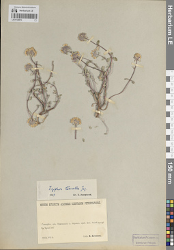
LE 01140573
Holotype of Ziziphora tomentosa Juz. det. Juzepczuk, Sergei Vasilievich at 1949
Collectors: Antonov, V. Collection date: 14.07.1912. Administrative regions: KG - Kyrgyzstan. Топоним: урочище Чункей-Сай. Place of collection: долина Аксай, средняя часть.Groups of specimens: Образцы сектора Средней Азии; Соглашение Минобрнауки №075-15-2021-1056; Типовые образцы сектора Средней Азии; Museum Botanicum Academiae Scientiarum PetropolitanaeOriginal label text:Семиреченская область Пржевальский уезд Нарынский край. Долина Аксай. средняя часть. Урочище Чункей сай
Landscape in location of collection: горыRecord creation: 2024-04-18, Denis Melnikov, PhotoScan D2.Citation: Specimen LE 01140573 // Virtual herbarium of Komarov Botanical Institute RAS — http://re.herbariumle.ru/01140573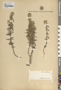
LE 01140572
Syntype of Ziziphora bungeana Juz. det. Juzepczuk, Sergei Vasilievich
Collectors: Busch Administrative regions: KZ - East Kazakhstan - Oskemen Qalasy. Groups of specimens: Образцы сектора Средней Азии; Соглашение Минобрнауки №075-15-2021-1056; Типовые образцы сектора Средней Азии; Herb. FischerOriginal label text:Усть-Каменогорск
Record creation: 2024-04-18, Denis Melnikov, PhotoScan D2.Citation: Specimen LE 01140572 // Virtual herbarium of Komarov Botanical Institute RAS — http://re.herbariumle.ru/01140572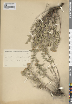
LE 01140571
Syntype of Ziziphora bungeana Juz. det. Juzepczuk, Sergei Vasilievich
Collectors: Politow Field collecting number: 336. Collection date: 1838. Groups of specimens: Образцы сектора Средней Азии; Соглашение Минобрнауки №075-15-2021-1056; Типовые образцы сектора Средней Азии; Museum Botanicum Academiae Scientiarum PetropolitanaeRecord creation: 2024-04-18, Denis Melnikov, PhotoScan D2.Citation: Specimen LE 01140571 // Virtual herbarium of Komarov Botanical Institute RAS — http://re.herbariumle.ru/01140571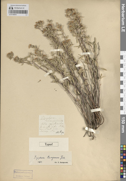
LE 01140570
Holotype of Ziziphora bungeana Juz. det. Juzepczuk, Sergei Vasilievich at 1954
Additional identifications: Ziziphora clinopodioides Lam. Collectors: illegible Groups of specimens: Образцы сектора Средней Азии; Соглашение Минобрнауки №075-15-2021-1056; Типовые образцы сектора Средней Азии; Herbarium Academiae Scientiarum Petropol.Original label text:(неразборчивый текст) Balch
Record creation: 2024-04-18, Denis Melnikov, PhotoScan D2.. Processing status: label contains unreadable dataCitation: Specimen LE 01140570 // Virtual herbarium of Komarov Botanical Institute RAS — http://re.herbariumle.ru/01140570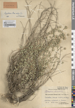
LE 01140569
Holotype of Ziziphora brevicalyx Juz. det. Juzepczuk, Sergei Vasilievich at 1954
Additional identifications: Ziziphora clinopodioides Lam. det. Busch Collectors: Lepeshkin, S.; Mukhamedzhanov, A. Field collecting number: 491. Collection date: 10.07.1936. Administrative regions: UZ - Uzbekistan; TJ - Tajikistan. Топоним: гора Баба-таг. Place of collection: против к. Чагам.Expedition: Бабатагская экспедиция НИБИ САГУ 1936 г. ()Groups of specimens: Образцы сектора Средней Азии; Соглашение Минобрнауки №075-15-2021-1056; Типовые образцы сектора Средней Азии; Ex Herbario Horti Botanici Universitatis Asiae MediaeOriginal label text:Юго-западный Памиро-алай. Гора Баба-таг. Гипсовые скалы по юго-западному склону хребта, против к. Чагам.
Landscape in location of collection: горыHabitat / plant community in location of collecting: гипсовые скалы по юго-западному склону хребтаRecord creation: 2024-04-18, Denis Melnikov, PhotoScan D2.Citation: Specimen LE 01140569 // Virtual herbarium of Komarov Botanical Institute RAS — http://re.herbariumle.ru/01140569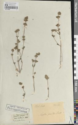
LE 01140568
Syntype of Ziziphora pungens Bunge det. Bunge, Alexander Andrejewitsch von
Additional identifications: Nepeta pusilla Benth. Collectors: Bunge, Alexander Andrejewitsch von Collection date: 1836. Топоним: гора Аркаул, Средняя Азия. Groups of specimens: Образцы сектора Средней Азии; Соглашение Минобрнауки №075-15-2021-1056; Типовые образцы сектора Средней Азии; Herb. Ledebour; Hortus Imperialis PetropolitanusOriginal label text:Arkaul
Record creation: 2024-04-18, Denis Melnikov, PhotoScan D2.Citation: Specimen LE 01140568 // Virtual herbarium of Komarov Botanical Institute RAS — http://re.herbariumle.ru/01140568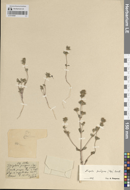
LE 01140567
Syntype of Ziziphora pungens Bunge
Additional identifications: Nepeta pungens (Bunge) Benth. det. Pojarkova, Antonina Ivanovna at 1952 Collectors: Bunge, Alexander Andrejewitsch von Field collecting number: 14. Collection date: 14.05.1826. Топоним: гора Аркаул, Средняя Азия. Groups of specimens: Образцы сектора Средней Азии; Соглашение Минобрнауки №075-15-2021-1056; Типовые образцы сектора Средней АзииOriginal label text:Altai Arkaul
Record creation: 2024-04-18, Denis Melnikov, PhotoScan D2.Citation: Specimen LE 01140567 // Virtual herbarium of Komarov Botanical Institute RAS — http://re.herbariumle.ru/01140567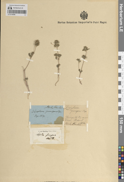
LE 01140566
Syntype of Ziziphora pungens Bunge det. Bunge, Alexander Andrejewitsch von at 1829
Additional identifications: Nepeta pungens (Bunge) Benth. det. Knorring, Olga Evertovna Топоним: гора Аркаул, Средняя Азия. Groups of specimens: Образцы сектора Средней Азии; Соглашение Минобрнауки №075-15-2021-1056; Типовые образцы сектора Средней Азии; Herb. FischerOriginal label text:In rupesribus montium Arkaul Altai
Landscape in location of collection: горыHabitat / plant community in location of collecting: на скалахRecord creation: 2024-04-18, Denis Melnikov, PhotoScan D2.Citation: Specimen LE 01140566 // Virtual herbarium of Komarov Botanical Institute RAS — http://re.herbariumle.ru/01140566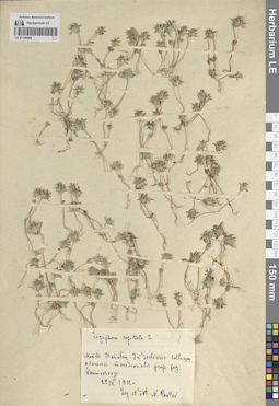
LE 01140565
Isolectotype of Ziziphora capitellata Juz. det. Juzepczuk, Sergei Vasilievich
Collectors: Pavlov, Nikolai Vasilievich Collection date: 22.05.1932. Administrative regions: KZ - South Kazakhstan; KZ - Qyzylorda Oblysy; KZ - Zhambyl Oblysy. Топоним: хребет Каратау (Сырдарьинский Каратау). Place of collection: у села Ванновское.Groups of specimens: Образцы сектора Средней Азии; Соглашение Минобрнауки №075-15-2021-1056; Типовые образцы сектора Средней АзииOriginal label text:Montes Karatau. In decliviis collium glareosis meridionalis prope pag. Vannovskoje.
Landscape in location of collection: горыHabitat / plant community in location of collecting: на склонах гравийного перевалаSubstrate in collecting location: gravelRecord creation: 2024-04-18, Denis Melnikov, PhotoScan D2.Citation: Specimen LE 01140565 // Virtual herbarium of Komarov Botanical Institute RAS — http://re.herbariumle.ru/01140565
LE 01140564
Specimen authenticum of Ziziphora pungens Bunge
Additional identifications: Nepeta pungens (Bunge) Benth. det. Pojarkova, Antonina Ivanovna at 1952 Collectors: Karelin, Grigorij Silyc Groups of specimens: Образцы сектора Средней Азии; Соглашение Минобрнауки №075-15-2021-1056; Типовые образцы сектора Средней Азии; Herbarium KarelinianumRecord creation: 2024-04-18, Denis Melnikov, PhotoScan D2.Citation: Specimen LE 01140564 // Virtual herbarium of Komarov Botanical Institute RAS — http://re.herbariumle.ru/01140564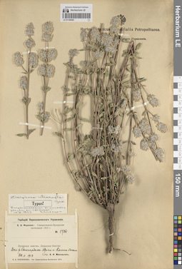
LE 01140563
Type of Ziziphora interrupta Juz. det. Juzepczuk, Sergei Vasilievich
Additional identifications: Type of Ziziphora interrupta Juz. ⟨В первоисточнике коллектор указан неправильно.⟩ det. Botschantzev, Victor Petrovič at 12.10.1959 Collectors: Michelson, Alexander Ivanovich Field collecting number: 1736. Collection date: 22.05.1913. Administrative regions: UZ - Bukhara Province. Топоним: река Сангардак. Place of collection: долина реки Сангардак, Юрчи и Катта-Дагана.Expedition: Самаркандско-Бухарская экспедиция (1913)Groups of specimens: Образцы сектора Средней Азии; Соглашение Минобрнауки №075-15-2021-1056; Типовые образцы сектора Средней Азии; Гербарий Переселенческого УправленияOriginal label text:Бухарское ханство, Денауское бекство Долина реки Сангардак. Юрчи и Катта-дагана
Landscape in location of collection: горыRecord creation: 2024-04-18, Denis Melnikov, PhotoScan D2.Citation: Specimen LE 01140563 // Virtual herbarium of Komarov Botanical Institute RAS — http://re.herbariumle.ru/01140563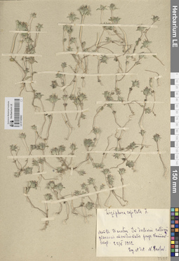
LE 01140562
Isolectotype of Ziziphora capitellata Juz. det. Juzepczuk, Sergei Vasilievich
Additional identifications: Ziziphora capitata L. det. Pavlov, Nikolai Vasilievich at 22.05.1932 Collectors: Pavlov, Nikolai Vasilievich Collection date: 22.05.1932. Administrative regions: KZ - Zhambyl Oblysy; KZ - Qyzylorda Oblysy; KZ - South Kazakhstan. Топоним: хребет Каратау (Сырдарьинский Каратау). Place of collection: у села Ванновское.Groups of specimens: Образцы сектора Средней Азии; Соглашение Минобрнауки №075-15-2021-1056; Типовые образцы сектора Средней АзииOriginal label text:Montes Karatau. In decliviis collium glareosis meridionalis prope pag. Vannovskoje.
Landscape in location of collection: горыHabitat / plant community in location of collecting: на склонах гравийного перевалаSubstrate in collecting location: gravelRecord creation: 2024-04-18, Denis Melnikov, PhotoScan D2.Citation: Specimen LE 01140562 // Virtual herbarium of Komarov Botanical Institute RAS — http://re.herbariumle.ru/01140562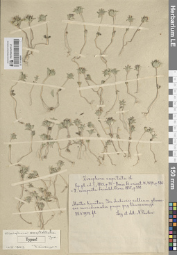
LE 01140561
Lectotype of Ziziphora capitellata Juz. det. Juzepczuk, Sergei Vasilievich
Additional identifications: Type of Ziziphora capitellata Juz. det. Botschantzev, Victor Petrovič at 12.10.1959 Collectors: Pavlov, Nikolai Vasilievich Collection date: 22.05.1932. Administrative regions: KZ - Qyzylorda Oblysy; KZ - South Kazakhstan; KZ - Zhambyl Oblysy. Топоним: хребет Каратау (Сырдарьинский Каратау). Place of collection: у села Ванновское.Groups of specimens: Образцы сектора Средней Азии; Соглашение Минобрнауки №075-15-2021-1056; Типовые образцы сектора Средней АзииOriginal label text:Montes Karatau. In decliviis collium glareosis meridionalis prope pag. Vannovskoje.
Landscape in location of collection: горыHabitat / plant community in location of collecting: на склонах гравийного перевалаSubstrate in collecting location: gravelRecord creation: 2024-04-18, Denis Melnikov, PhotoScan D2.Citation: Specimen LE 01140561 // Virtual herbarium of Komarov Botanical Institute RAS — http://re.herbariumle.ru/01140561
LE 01269209
Ziziphora rotundifolia (Pers.) Melnikov det. Melnikov, Denis Germanovich at 18.04.2024
Additional identifications: Calamintha graveolens (M.Bieb.) Benth. det. Popov, Mikhail Grigorevich (Popow) at 1915; Acinos graveolens (Bieb.) Link det. Borissova, Antonina Georgievna at 1959 Collectors: Popov, Mikhail Grigorevich (Popow) Field collecting number: 10997. Collection date: 04.1915. Administrative regions: TJ - Viloyati Sughd - Khodzhentskiy Rayon. Топоним: хребет Моголтау (Могольтау). Place of collection: в сае под горой Спа.Groups of specimens: Образцы сектора Средней Азии; Соглашение Минобрнауки №075-15-2021-1056; И. И. Спрыгин и М. Г. Попов. Гербарий юго-восточной части Самаркандской области.Original label text:Могол-Тау, в сае под горой Спа.
Landscape in location of collection: горыHabitat / plant community in location of collecting: в саеRecord creation: 2024-04-18, Denis Melnikov, PhotoScan D2.Citation: Specimen LE 01269209 // Virtual herbarium of Komarov Botanical Institute RAS — http://re.herbariumle.ru/01269209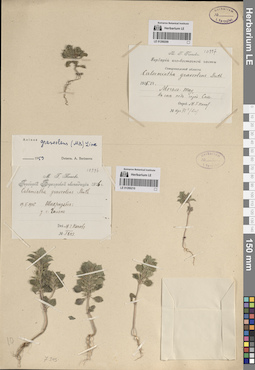
LE 01269210
Ziziphora rotundifolia (Pers.) Melnikov det. Melnikov, Denis Germanovich at 18.04.2024
Additional identifications: Calamintha graveolens (M.Bieb.) Benth. det. Popov, Mikhail Grigorevich (Popow) at 1916; Acinos graveolens (Bieb.) Link det. Borissova, Antonina Georgievna at 1959 Collectors: Popov, Mikhail Grigorevich (Popow) Field collecting number: 10996. Collection date: 19.05.1916. Administrative regions: UZ - Qashqadaryo Province - Shahrisabz Tumani. Топоним: село Гилян. Place of collection: у села Гилян.Groups of specimens: Образцы сектора Средней Азии; Соглашение Минобрнауки №075-15-2021-1056; М. Г. Попов. Гербарий Бухарской экспедиции-1916Original label text:Шахризябс: у села Гилян
Landscape in location of collection: горыRecord creation: 2024-04-18, Denis Melnikov, PhotoScan D2.Citation: Specimen LE 01269210 // Virtual herbarium of Komarov Botanical Institute RAS — http://re.herbariumle.ru/01269210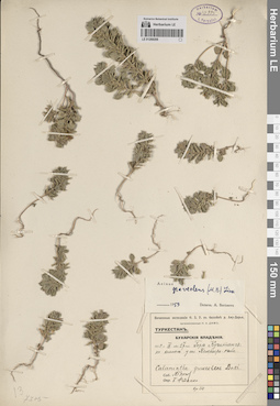
LE 01269208
Ziziphora rotundifolia (Pers.) Melnikov det. Melnikov, Denis Germanovich at 18.04.2024
Additional identifications: Calamintha graveolens (M.Bieb.) Benth. det. Fedtschenko, Boris Alexeevich at 1915; Acinos graveolens (Bieb.) Link det. Borissova, Antonina Georgievna at 1955 Collectors: Popov, Mikhail Grigorevich (Popow) Collection date: 27.04.1915. Administrative regions: UZ - Bukhara Province. Subregion: горы Куштанг. Топоним: селение Кемпыр-Тюбе. Place of collection: у селения Кемпыр-Тюбе.Expedition: Почвенные экспедиции О. З. У. в бассейне р. Аму-Дарьи, организованные Н.А. Димо ()Groups of specimens: Образцы сектора Средней Азии; Соглашение Минобрнауки №075-15-2021-1056; Туркестан. Бухарские владения.Original label text:Горы Куштанг: по холмам у селения Кемпыр-тюбе.
Landscape in location of collection: граница субтропических сухих и теплоумеренных (предгорных) степейHabitat / plant community in location of collecting: на холмахRecord creation: 2024-04-18, Denis Melnikov, PhotoScan D2.Citation: Specimen LE 01269208 // Virtual herbarium of Komarov Botanical Institute RAS — http://re.herbariumle.ru/01269208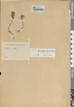
LE 01269207
Ziziphora rotundifolia (Pers.) Melnikov det. Melnikov, Denis Germanovich at 18.04.2024
Additional identifications: Acinos graveolens (Bieb.) Link det. Borissova, Antonina Georgievna at 1959 Collectors: Busch Field collecting number: 133. Administrative regions: UZ - Uzbekistan; TJ - Tajikistan. Groups of specimens: Образцы сектора Средней Азии; Соглашение Минобрнауки №075-15-2021-1056; От Туркестанской Сел.-Хоз. Опытной СтанцииRecord creation: 2024-04-18, Denis Melnikov, PhotoScan D2.Citation: Specimen LE 01269207 // Virtual herbarium of Komarov Botanical Institute RAS — http://re.herbariumle.ru/01269207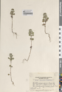
LE 01269206
Ziziphora rotundifolia (Pers.) Melnikov det. Melnikov, Denis Germanovich at 18.04.2024
Additional identifications: Acinos graveolens (Bieb.) Link det. Anonymous Collectors: Busch Field collecting number: 14. Collection date: 22.05.1987. Administrative regions: UZ - Toshkent Viloyati - Bustonliq Tumani. Subregion: нижнее течение реки Пскем. Топоним: ручей Кайнарсай. Place of collection: долина ручья Кайнарсай, в окрестностях Горно-Ботанической станции.Groups of specimens: Образцы сектора Средней Азии; Соглашение Минобрнауки №075-15-2021-1056; Гербарий Ботанического Института Академии наук СССРOriginal label text:Узбекская ССР, нижнее течение реки Пскем, долина ручья Кайнарсай, в окрестностях Горно-Ботанической станции, склон южной экспозиции
Landscape in location of collection: горыHabitat / plant community in location of collecting: склон южной экспозицииRecord creation: 2024-04-18, Denis Melnikov, PhotoScan D2.Citation: Specimen LE 01269206 // Virtual herbarium of Komarov Botanical Institute RAS — http://re.herbariumle.ru/01269206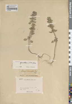
LE 01269205
Ziziphora rotundifolia (Pers.) Melnikov det. Melnikov, Denis Germanovich at 18.04.2024
Additional identifications: Satureja rotundifolia (Pers.) Briq. det. Ikonnikov-Galitzky, Nikolai Petrovic at 20.03.1936; Acinos graveolens (Bieb.) Link det. Borissova, Antonina Georgievna at 1959 Collectors: Lipsky, Vladimir Ippolitovich Field collecting number: 4487. Collection date: 07.06.1896. Administrative regions: UZ - Qashqadaryo Province - Shahrisabz Tumani. Subregion: Гилян. Place of collection: 6700 футов (2010 метров) над уровнем моря.Groups of specimens: Образцы сектора Средней Азии; Соглашение Минобрнауки №075-15-2021-1056; В. И. Липский, Средняя АзияOriginal label text:Бухара. Шахрисябс. Гилян, 6700'
Landscape in location of collection: горыCoordinates (geographic position): 2010 m a.s.l.Record creation: 2024-04-18, Denis Melnikov, PhotoScan D2.Citation: Specimen LE 01269205 // Virtual herbarium of Komarov Botanical Institute RAS — http://re.herbariumle.ru/01269205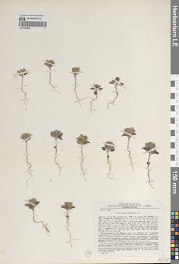
LE 01269204
Ziziphora rotundifolia (Pers.) Melnikov det. Melnikov, Denis Germanovich at 18.04.2024
Additional identifications: Acinos rotundifolius J. Persson det. Tulyaganova, Markhamat Tulyaganovna at 1988 Collectors: Botschantzev, Victor Petrovič Field collecting number: 6794. Collection date: 02.05.1930. Administrative regions: UZ - Surxondaryo Viloyati - Boysun Tumani. Subregion: юго-западные отроги Гиссарского хребта. Топоним: кишлак Таш-Как. Place of collection: вблизи кишлака Таш-Как, к востоку от города Байсун.Groups of specimens: Образцы сектора Средней Азии; Соглашение Минобрнауки №075-15-2021-1056; Гербарий Флоры СССР, издаваемый Ботаническим институтом им. В. Л. Комарова Академии наук СССРOriginal label text:Узбекская ССР, юго-западные отроги Гиссарского хребта, на каменисто-песчаных склонах вблизи кишлака Таш-Как (к востоку от города Байсун). - Uzbekistania, brachia austro-occidentalia jugi Hissarici, ad declivia saxoso-arenosa haud procul a pago Tasch-Kak (orientem versus urbis Baissun).
Landscape in location of collection: горыHabitat / plant community in location of collecting: на каменисто-песчаных склонахSubstrate in collecting location: sandyRecord creation: 2024-04-18, Denis Melnikov, PhotoScan D2.Citation: Specimen LE 01269204 // Virtual herbarium of Komarov Botanical Institute RAS — http://re.herbariumle.ru/01269204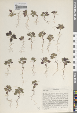
LE 01269203
Ziziphora rotundifolia (Pers.) Melnikov det. Melnikov, Denis Germanovich at 18.04.2024
Additional identifications: Acinos rotundifolius J. Persson det. Tulyaganova, Markhamat Tulyaganovna at 1988 Collectors: Botschantzev, Victor Petrovič Field collecting number: 6794. Collection date: 02.05.1930. Administrative regions: UZ - Surxondaryo Viloyati - Boysun Tumani. Subregion: юго-западные отроги Гиссарского хребта. Топоним: кишлак Таш-Как. Place of collection: вблизи кишлака Таш-Как, к востоку от города Байсун.Groups of specimens: Образцы сектора Средней Азии; Соглашение Минобрнауки №075-15-2021-1056; Гербарий Флоры СССР, издаваемый Ботаническим институтом им. В. Л. Комарова Академии наук СССРOriginal label text:Узбекская ССР, юго-западные отроги Гиссарского хребта, на каменисто-песчаных склонах вблизи кишлака Таш-Как (к востоку от города Байсун). - Uzbekistania, brachia austro-occidentalia jugi Hissarici, ad declivia saxoso-arenosa haud procul a pago Tasch-Kak (orientem versus urbis Baissun).
Landscape in location of collection: горыHabitat / plant community in location of collecting: на каменисто-песчаных склонахSubstrate in collecting location: sandyRecord creation: 2024-04-18, Denis Melnikov, PhotoScan D2.Citation: Specimen LE 01269203 // Virtual herbarium of Komarov Botanical Institute RAS — http://re.herbariumle.ru/01269203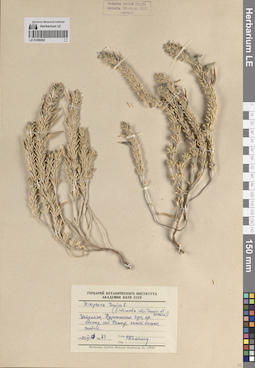
LE 01269202
Ziziphora tenuior L. ⟨f. intermedia между Z. tunuior и Z. persica⟩ det. Kamelin, Rudolph Vladimirovich at 1972
Collectors: Kamelin, Rudolph Vladimirovich Field collecting number: 83. Collection date: 13.07.1972. Administrative regions: UZ - Navoiy Province - Nurota Tumani. Subregion: Нуратинские горы. Топоним: сай Петыр. Place of collection: хребет Актау.Groups of specimens: Образцы сектора Средней Азии; Соглашение Минобрнауки №075-15-2021-1056; Гербарий Ботанического Института Академии наук СССРLandscape in location of collection: горыHabitat / plant community in location of collecting: каменистые склоны, шиблякRecord creation: 2024-04-18, Denis Melnikov, PhotoScan D2.Citation: Specimen LE 01269202 // Virtual herbarium of Komarov Botanical Institute RAS — http://re.herbariumle.ru/01269202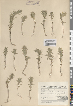
LE 01269201
Ziziphora tenuior L. det. Medvedeva, Liudmila Ivanovna at 1958
Collectors: Knorring, Olga Evertovna; Markova, Lydia Pavlovna; Medvedeva, L. удалить Collection date: 16.05.1958. Administrative regions: UZ - Toshkent Viloyati - Toshkent Tumani. Place of collection: близ железнодорожной станции Сары-Агач (Сарыагаш) (находится в Туркестанской области Казахстана).Groups of specimens: Образцы сектора Средней Азии; Соглашение Минобрнауки №075-15-2021-1056; Гербарий Ботанического Института Академии наук СССРOriginal label text:Узбекская ССР. Близ железнодорожной станции Сары-Агач, глинистая полупустыня.
Landscape in location of collection: теплоумеренные полупустыниHabitat / plant community in location of collecting: глинистая полупустыняRecord creation: 2024-04-18, Denis Melnikov, PhotoScan D2.Citation: Specimen LE 01269201 // Virtual herbarium of Komarov Botanical Institute RAS — http://re.herbariumle.ru/01269201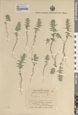
LE 01269200
Ziziphora tenuior L. det. Spiridonov, M. D. at 1915
Collectors: Spiridonov, M. D. Administrative regions: UZ - Uzbekistan. Subregion: Кызыл-Кум. Топоним: Атагузы. Expedition: Изыскания в Голодной степи-1915 ()Groups of specimens: Образцы сектора Средней Азии; Соглашение Минобрнауки №075-15-2021-1056; Hortus Botanicus Imperialis Petri Magni.; Отдел Земельных Улучшений; Plantae in deserto Kisyl-Kum a M. Spiridonow lectae.Original label text:Самаркандская область Джизакский уезд: Пески Кизыл-Кумы Кол. Шакыр-к. Атагузы. Котловины. Суглинок
Landscape in location of collection: пустыняHabitat / plant community in location of collecting: котловины, суглинокSubstrate in collecting location: loamyRecord creation: 2024-04-18, Denis Melnikov, PhotoScan D2.Citation: Specimen LE 01269200 // Virtual herbarium of Komarov Botanical Institute RAS — http://re.herbariumle.ru/01269200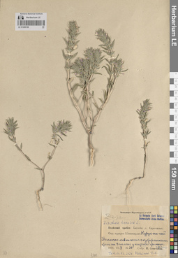
LE 01269199
Ziziphora tenuior L. det. Melnikov, Denis Germanovich at 01.03.2024
Collectors: Sovetkina, M. M. Field collecting number: 30. Collection date: 09.07.1935. Administrative regions: UZ - Fergana - Farg`ona Tumani. Subregion: Алайский хребет. Топоним: Курук-Ан-Сай. Place of collection: бассейн реки Кара-казык, окрестности курорта Шахимардан.Expedition: Экспедиция Наркомздрава УзССР ()Groups of specimens: Образцы сектора Средней Азии; Соглашение Минобрнауки №075-15-2021-1056; Ex Herbario Horti Botanici Universitatis Asiae MediaeOriginal label text:Алайский хребет. Бассейн реки Кара-казык. Окрестности курорта Шахимардан. Курук-ан-сай Полынно-ковыльная с кустарниками степь на западном склоне у нижней границы арчи
Landscape in location of collection: горыHabitat / plant community in location of collecting: полынно-ковыльная с кустарниками степь на западном склоне у нижней границы арчиRecord creation: 2024-04-18, Denis Melnikov, PhotoScan D2.Citation: Specimen LE 01269199 // Virtual herbarium of Komarov Botanical Institute RAS — http://re.herbariumle.ru/01269199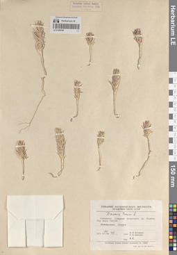
LE 01269198
Ziziphora tenuior L. det. Kamelin, Rudolph Vladimirovich at 1971
Collectors: Botschantzev, Victor Petrovič; Kamelin, Rudolph Vladimirovich Field collecting number: 431. Collection date: 24.06.1971. Administrative regions: UZ - Navoiy Province - Nurota Tumani. Subregion: северный макросклон хребта Нуратау. Топоним: кишлак Синтоб (Сентяб). Place of collection: окрестности кишлака Синтоб (Сентяб).Groups of specimens: Образцы сектора Средней Азии; Соглашение Минобрнауки №075-15-2021-1056; Гербарий Ботанического Института Академии наук СССРOriginal label text:Узбекистан. Северный макросклон хребта Нуратау. Окрестности кишлака Синтоб. каменистые склоны
Landscape in location of collection: горыHabitat / plant community in location of collecting: каменистые склоныRecord creation: 2024-04-18, Denis Melnikov, PhotoScan D2.Citation: Specimen LE 01269198 // Virtual herbarium of Komarov Botanical Institute RAS — http://re.herbariumle.ru/01269198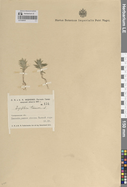
LE 01269197
Ziziphora tenuior L. det. Fedtschenko, Olga Alexandrowna, Fedtschenko, Boris Alexeevich at 1915
Collectors: Fedtschenko, Olga Alexandrowna; Fedtschenko, Boris Alexeevich Field collecting number: 154. Collection date: 10.04.1915. Administrative regions: UZ - Jizzakh Province - Jizzax Shahri. Топоним: Пьяная гора, Джизак. Groups of specimens: Образцы сектора Средней Азии; Соглашение Минобрнауки №075-15-2021-1056; Hortus Botanicus Imperialis Petri Magni.; О. А. и Б. А. Федченко: Растения Самаркандской области-1915Original label text:Самаркандская область: Джизак, южные склоны Пьяной горы.
Landscape in location of collection: граница субтропических сухих и теплоумеренных (предгорных) степейHabitat / plant community in location of collecting: южные склоны горыRecord creation: 2024-04-18, Denis Melnikov, PhotoScan D2.Citation: Specimen LE 01269197 // Virtual herbarium of Komarov Botanical Institute RAS — http://re.herbariumle.ru/01269197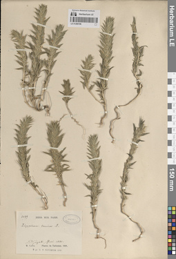
LE 01269196
Ziziphora tenuior L. det. Guillaume Capus (M. Capus, Mission Capus) at 1881
Collectors: Guillaume Capus (M. Capus, Mission Capus) Field collecting number: 1039. Collection date: 05.1881. Administrative regions: UZ - Jizzakh Province - Jizzax Shahri. Groups of specimens: Образцы сектора Средней Азии; Соглашение Минобрнауки №075-15-2021-1056; Herb. Mus. Paris.; Ex Herbario Musei Parisiensis; M. Capus. Plantes du Turkestan. 1881.Original label text:Djizak
Landscape in location of collection: граница субтропических сухих и теплоумеренных (предгорных) степейRecord creation: 2024-04-18, Denis Melnikov, PhotoScan D2.Citation: Specimen LE 01269196 // Virtual herbarium of Komarov Botanical Institute RAS — http://re.herbariumle.ru/01269196
LE 01269195
Ziziphora tenuior L. det. Fedtschenko, Olga Alexandrowna, Fedtschenko, Boris Alexeevich at 1915
Collectors: Fedtschenko, Olga Alexandrowna; Fedtschenko, Boris Alexeevich Field collecting number: 241. Collection date: 12.04.1915. Administrative regions: UZ - Jizzakh Province - Jizzax Shahri. Топоним: Тамерлановы ворота, Джизак. Groups of specimens: Образцы сектора Средней Азии; Соглашение Минобрнауки №075-15-2021-1056; Hortus Botanicus Imperialis Petri Magni.; О. А. и Б. А. Федченко: Растения Самаркандской области-1915Original label text:Самаркандская область: Джизак, Тамерлановы ворота; южный каменистый склон.
Landscape in location of collection: граница субтропических сухих и теплоумеренных (предгорных) степейHabitat / plant community in location of collecting: южный каменистый склонRecord creation: 2024-04-18, Denis Melnikov, PhotoScan D2.Citation: Specimen LE 01269195 // Virtual herbarium of Komarov Botanical Institute RAS — http://re.herbariumle.ru/01269195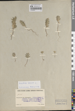
LE 01269194
Ziziphora tenuior L. det. Melnikov, Denis Germanovich at 01.03.2024
Collectors: Dolenko, G. I. Field collecting number: 334. Collection date: 04.05.1913. Administrative regions: UZ - Fergana. Топоним: Ассаке-Адыр. Place of collection: у кишлака Ассаке.Groups of specimens: Образцы сектора Средней Азии; Соглашение Минобрнауки №075-15-2021-1056; Herbarium Academiae Scientiarum Petropol.; Museum Botanicum Academiae Scientiarum PetropolitanaeOriginal label text:Ферганская область Скобелевский уезд Ассаке-адыр у кишлака Ассаке; серозем с конкрециями гипса на лессе покрывающем конгломерат.
Landscape in location of collection: горыHabitat / plant community in location of collecting: серозем с конкрециями гипса на лессе покрывающем конгломератSubstrate in collecting location: sierozem with gypsum concretions on loess coverRecord creation: 2024-04-18, Denis Melnikov, PhotoScan D2.Citation: Specimen LE 01269194 // Virtual herbarium of Komarov Botanical Institute RAS — http://re.herbariumle.ru/01269194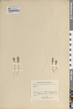
LE 01269193
Ziziphora tenuior L. det. Melnikov, Denis Germanovich at 18.04.2024
Collectors: Michelson, Alexander Ivanovich Field collecting number: 265. Collection date: 10.05.1909. Administrative regions: UZ - Jizzakh Province. Топоним: железнодорожная станция Куропаткино, Самаркандская область (современные данные отсутствуют). Expedition: Липский В.И. Экспедиция в Копальский уезд 1909 г. (1909)Groups of specimens: Образцы сектора Средней Азии; Соглашение Минобрнауки №075-15-2021-1056; Гербарий Переселенческого УправленияOriginal label text:Самаркандская область: Джизакский уезд станция Куропаткино Средне-Азиатской железной дороги
Landscape in location of collection: горыRecord creation: 2024-04-18, Denis Melnikov, PhotoScan D2.Citation: Specimen LE 01269193 // Virtual herbarium of Komarov Botanical Institute RAS — http://re.herbariumle.ru/01269193
LE 01269192
Ziziphora tenuior L. det. Fedtschenko, Olga Alexandrowna, Fedtschenko, Boris Alexeevich at 1915
Collectors: Fedtschenko, Olga Alexandrowna; Fedtschenko, Boris Alexeevich Field collecting number: 97. Collection date: 07.04.1915. Administrative regions: UZ - Samarqand Viloyati. Топоним: река Сырдарья. Place of collection: 45 верст от Сырдарьи.Groups of specimens: Образцы сектора Средней Азии; Соглашение Минобрнауки №075-15-2021-1056; Hortus Botanicus Imperialis Petri Magni.; О. А. и Б. А. Федченко: Растения Самаркандской области-1915Original label text:Самаркандская область: В степи, 45 верст от Сыр-Дарьи.
Landscape in location of collection: теплоумеренные (предгорные) степиRecord creation: 2024-04-18, Denis Melnikov, PhotoScan D2.Citation: Specimen LE 01269192 // Virtual herbarium of Komarov Botanical Institute RAS — http://re.herbariumle.ru/01269192
LE 01269191
Ziziphora tenuior L. det. Pryahina, M. at 1964
Collectors: Pryahina, M. Collection date: 26.05.1964. Administrative regions: UZ - Bukhara Province. Subregion: хребет Каратау. Place of collection: к югу от перевала Джизлон.Groups of specimens: Образцы сектора Средней Азии; Соглашение Минобрнауки №075-15-2021-1056; Гербарий Института ботаники АН УзССРOriginal label text:Узбекистан. Бухарская область, хребет Кара-тау. К югу от перевала Джизлон. Каменистый участок.
Landscape in location of collection: горыHabitat / plant community in location of collecting: каменистый участокRecord creation: 2024-04-18, Denis Melnikov, PhotoScan D2.Citation: Specimen LE 01269191 // Virtual herbarium of Komarov Botanical Institute RAS — http://re.herbariumle.ru/01269191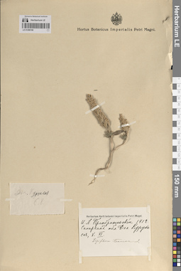
LE 01269190
Ziziphora tenuior L. det. Fedtschenko, Olga Alexandrowna, Fedtschenko, Boris Alexeevich
Collectors: Preobrazhensky, I. A. Collection date: 08.06.1912. Administrative regions: UZ - Qashqadaryo Province - Chiroqchi Tumani. Топоним: Курук-Сай. Place of collection: долина Курук-Сая.Groups of specimens: Образцы сектора Средней Азии; Соглашение Минобрнауки №075-15-2021-1056; Hortus Botanicus Imperialis Petri Magni.; Herbarium Horti botanici Imperialis Petri MagniOriginal label text:Самаркандская область Долина Курук-сая
Landscape in location of collection: горыRecord creation: 2024-04-18, Denis Melnikov, PhotoScan D2.Citation: Specimen LE 01269190 // Virtual herbarium of Komarov Botanical Institute RAS — http://re.herbariumle.ru/01269190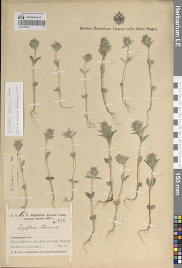
LE 01269189
Ziziphora persica Bunge det. Melnikov, Denis Germanovich at 01.03.2024
Additional identifications: Ziziphora tenuior L. det. Fedtschenko, Olga Alexandrowna, Fedtschenko, Boris Alexeevich at 1915; Ziziphora persica Bunge det. Anonymous Collectors: Fedtschenko, Olga Alexandrowna; Fedtschenko, Boris Alexeevich Field collecting number: 478. Collection date: 26.04.1915. Administrative regions: UZ - Samarqand Viloyati - Urgut Tumani. Топоним: населенный пункт Аманкутан. Place of collection: близ почтовой станции.Groups of specimens: Образцы сектора Средней Азии; Соглашение Минобрнауки №075-15-2021-1056; Hortus Botanicus Imperialis Petri Magni.; О. А. и Б. А. Федченко: Растения Самаркандской области-1915Original label text:Самаркандская область: Аман-Кутан, посевы богарного ячменя близ почтовой станции.
Landscape in location of collection: горыHabitat / plant community in location of collecting: посевы богарного ячменяRecord creation: 2024-04-18, Denis Melnikov, PhotoScan D2.Citation: Specimen LE 01269189 // Virtual herbarium of Komarov Botanical Institute RAS — http://re.herbariumle.ru/01269189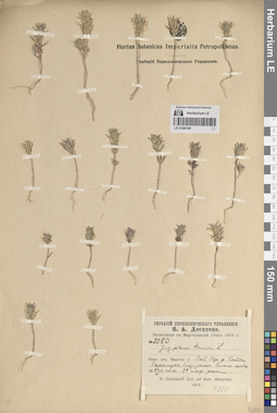
LE 01269188
Ziziphora tenuior L. det. Desyatova-Shostenko, Natalya Alekseevna at 1913
Collectors: Desyatov, N. A. Field collecting number: 2050. Collection date: 20.06.1913. Administrative regions: UZ - Fergana - Marg`ilon Shahri. Топоним: река Катта-Карамук. Place of collection: левый берег реки Катта-Карамук, близь устья.Expedition: Н. А. Десятов. Экспедиция в Маргеланский уезд-1913 ()Groups of specimens: Образцы сектора Средней Азии; Соглашение Минобрнауки №075-15-2021-1056; Гербарий Переселенческого УправленияOriginal label text:Ферганская область Маргеланский уезд Левый берег реки Катта Карамук, близь устья. Сильно щебнистая 3 терраса реки
Landscape in location of collection: горыHabitat / plant community in location of collecting: сильно щебнистая 3 терраса рекиRecord creation: 2024-04-18, Denis Melnikov, PhotoScan D2.Citation: Specimen LE 01269188 // Virtual herbarium of Komarov Botanical Institute RAS — http://re.herbariumle.ru/01269188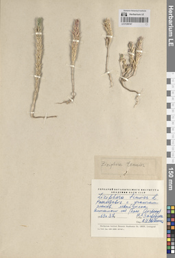
LE 01269187
Ziziphora tenuior L. det. Vvedensky, Aleksei Ivanovich at 1963
Collectors: Zagrebina, N. L. Collection date: 03.07.1963. Administrative regions: UZ - Toshkent Viloyati - Piskent Tumani. Subregion: бассейн реки Ангрен. Топоним: Алмалык-Сай. Place of collection: левый склон Алмалык-Сая.Groups of specimens: Образцы сектора Средней Азии; Соглашение Минобрнауки №075-15-2021-1056; Гербарий Ботанического Института Академии наук СССРOriginal label text:Разнотравье с участием злаков. левый склон Алмалык-сая (бассейн Ангрена)
Landscape in location of collection: горыHabitat / plant community in location of collecting: разнотравье с участием злаковRecord creation: 2024-04-18, Denis Melnikov, PhotoScan D2.Citation: Specimen LE 01269187 // Virtual herbarium of Komarov Botanical Institute RAS — http://re.herbariumle.ru/01269187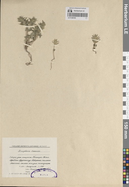
LE 01269186
Ziziphora tenuior L. det. Zapromotova N.S. at 1958
Collectors: Zapromotova N.S. Field collecting number: 297. Collection date: 02.04.1958. Administrative regions: UZ - Uzbekistan. Subregion: северо-западные отроги гор Памиро-Алай. Топоним: Кан-Сай. Place of collection: северные склоны хребта Нуратау.Groups of specimens: Образцы сектора Средней Азии; Соглашение Минобрнауки №075-15-2021-1056; Гербарий Института ботаники АН УзССРOriginal label text:Северо-западные отроги Памиро-Алая. Хребет Нуратау. Северные склоны. Кан-сай склон юго-западной экспозиции.
Landscape in location of collection: горыHabitat / plant community in location of collecting: склон сая юго-западной экспозицииRecord creation: 2024-04-18, Denis Melnikov, PhotoScan D2.Citation: Specimen LE 01269186 // Virtual herbarium of Komarov Botanical Institute RAS — http://re.herbariumle.ru/01269186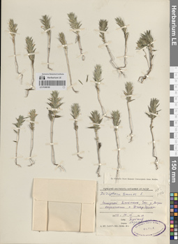
LE 01269185
Ziziphora tenuior L. det. Lazkov, Georgiy Anatol'evich; Laz'kov at 2013
Additional identifications: Ziziphora tenuior L. det. Melnikov, Denis Germanovich at 01.03.2024 Collectors: Tuyshev Field collecting number: 14. Collection date: 14.06.1953. Administrative regions: UZ - Toshkent Viloyati - Ohangaron Shahri. Subregion: Западный Тяньшань. Топоним: река Ангрен. Place of collection: окрестности села Джар-Булак.Groups of specimens: Образцы сектора Средней Азии; Соглашение Минобрнауки №075-15-2021-1056; Гербарий Института ботаники АН УзССР; Ex Herbario Horti Botanici Universitatis Asiae MediaeOriginal label text:Западный Тяньшань, Засыхающая река Ангрен окрестности села Джар-булак
Landscape in location of collection: горыRecord creation: 2024-04-18, Denis Melnikov, PhotoScan D2.Citation: Specimen LE 01269185 // Virtual herbarium of Komarov Botanical Institute RAS — http://re.herbariumle.ru/01269185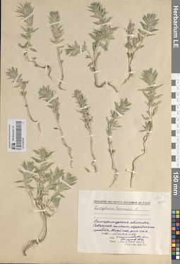
LE 01269184
Ziziphora tenuior L. det. Lazkov, Georgiy Anatol'evich; Laz'kov at 2013
Additional identifications: Ziziphora tenuior L. det. Melnikov, Denis Germanovich at 01.03.2024 Collectors: Zapromotova N.S. Field collecting number: 52. Collection date: 15.05.1952. Administrative regions: UZ - Navoiy Province - Nurota Tumani. Subregion: Нуратинский хребет. Топоним: Алай-Сай. Place of collection: северные склоны Нуратинского хребта.Groups of specimens: Образцы сектора Средней Азии; Соглашение Минобрнауки №075-15-2021-1056; Гербарий Института ботаники АН УзССРOriginal label text:Самаркандская область. Северные склоны Нуратинского хребта. Алай-сай, дно сая.
Landscape in location of collection: горыHabitat / plant community in location of collecting: дно саяRecord creation: 2024-04-18, Denis Melnikov, PhotoScan D2.Citation: Specimen LE 01269184 // Virtual herbarium of Komarov Botanical Institute RAS — http://re.herbariumle.ru/01269184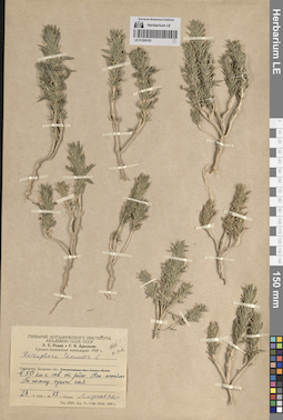
LE 01269183
Ziziphora tenuior L. det. Lazkov, Georgiy Anatol'evich; Laz'kov at 2013
Additional identifications: Ziziphora tenuior L. det. Melnikov, Denis Germanovich at 01.03.2024 Collectors: Rodin, Leonid Efimovich; Arkadiev, G. V. Field collecting number: 75. Collection date: 24.05.1948. Administrative regions: UZ - Bukhara Province. Топоним: родник Ай-Алытма. Place of collection: в 50 километрах к северу от родника Аяк-Алытма.Expedition: Л. Е. Родин и Г. В. Аркадьев. Средне-Азиатская экспедиция-1948 ()Groups of specimens: Образцы сектора Средней Азии; Соглашение Минобрнауки №075-15-2021-1056; Гербарий Ботанического Института Академии наук СССРOriginal label text:Узбекистан, Бухарская область, в 50 километрах к северу от родника Аяк-алытма По склону сухого сая.
Landscape in location of collection: горыHabitat / plant community in location of collecting: по склону сухого саяRecord creation: 2024-04-18, Denis Melnikov, PhotoScan D2.Citation: Specimen LE 01269183 // Virtual herbarium of Komarov Botanical Institute RAS — http://re.herbariumle.ru/01269183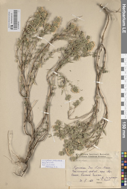
LE 01269182
Ziziphora pedicellata Pazij & Vved. det. Melnikov, Denis Germanovich at 01.03.2024
Collectors: Lazarenko, A.; Zerov, Dmitriy Konstantinovich Collection date: 20.09.1929. Administrative regions: KZ - Kazakhstan. Subregion: Западный Тянь-Шань. Топоним: Большой Чимчак. Place of collection: горы Ау-Кашка, Чаткальский хребет.Groups of specimens: Образцы сектора Средней Азии; Соглашение Минобрнауки №075-15-2021-1056; Herbarium Instituti Botanici Academiae Scientiarum UcrainiaeOriginal label text:Туркестан. Западный Тянь-Шань, Чаткальский хребет, горы Ау-Кашка, Большой Чимчак.
Landscape in location of collection: горыRecord creation: 2024-04-18, Denis Melnikov, PhotoScan D2.Citation: Specimen LE 01269182 // Virtual herbarium of Komarov Botanical Institute RAS — http://re.herbariumle.ru/01269182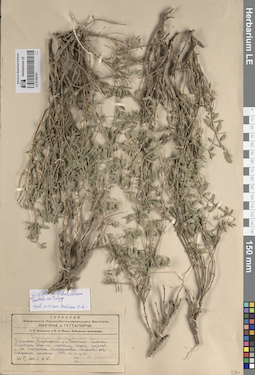
LE 01269181
Ziziphora vichodceviana Tkatsch. ex Tulyag. det. Melnikov, Denis Germanovich at 01.03.2024
Additional identifications: Ziziphora clinopodioides Lam. det. Jarmolenko, Alexander Viktorovich at 1931 Collectors: Jarmolenko, Alexander Viktorovich Field collecting number: 78. Collection date: 26.06.1931. Administrative regions: UZ - Surxondaryo Viloyati - Sherobod Tumani. Subregion: хребет Куштанг. Топоним: поселок Ходжанка. Place of collection: восточные склоны Куштанга, гора по правому берегу ущелья у поселка Ходжанка, 1700 метров над уровнем моря.Expedition: А. В. Ярмоленко и И. А. Фирсв: Байсунская экспедиция ()Groups of specimens: Образцы сектора Средней Азии; Соглашение Минобрнауки №075-15-2021-1056; Гербарий Всесоюзного Научно-исследовательского института каучука и гуттаперчиOriginal label text:Узбекистан. Ширабадский район. Восточные склоны Куштанга. Гора по правому берегу ущелья у поселка Ходжанка. Мелкоземистые полынно-разнотравные склоны 1700 метров над уровнем моря
Landscape in location of collection: горыHabitat / plant community in location of collecting: мелкоземистые полынно-разнотравные склоныCoordinates (geographic position): 1700 m a.s.l.Record creation: 2024-04-18, Denis Melnikov, PhotoScan D2.Citation: Specimen LE 01269181 // Virtual herbarium of Komarov Botanical Institute RAS — http://re.herbariumle.ru/01269181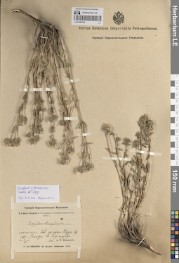
LE 01269180
Ziziphora vichodceviana Tkatsch. ex Tulyag. det. Melnikov, Denis Germanovich at 01.03.2024
Additional identifications: Ziziphora clinopodioides Lam. det. Michelson, Alexander Ivanovich at 1914 Collectors: Michelson, Alexander Ivanovich Collection date: 01.07.1914. Administrative regions: UZ - Jizzakh Province - Baxmal Tumani. Subregion: Туркестанский хребет. Place of collection: северный склон Туркестанского хребта из Усмата в Багмазар.Expedition: О. Э. фон Кнорринг: Экспедиция в Самаркандскую обл. 1914 г. // O. von Knorring. Iter ad prov. Samarkand. (1914)Groups of specimens: Образцы сектора Средней Азии; Соглашение Минобрнауки №075-15-2021-1056; Hortus Botanicus Imperialis Petropolitanus.; Гербарий Переселенческого УправленияOriginal label text:Джизакский уезд Северный склон Туркестанского хребта из Усмата в Багмазар.
Landscape in location of collection: горыRecord creation: 2024-04-18, Denis Melnikov, PhotoScan D2.Citation: Specimen LE 01269180 // Virtual herbarium of Komarov Botanical Institute RAS — http://re.herbariumle.ru/01269180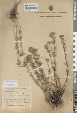
LE 01269179
Ziziphora brevicalyx Juz. det. Melnikov, Denis Germanovich at 01.03.2024
Additional identifications: Ziziphora clinopodioides Lam. det. Michelson, Alexander Ivanovich at 1914 Collectors: Michelson, Alexander Ivanovich Collection date: 01.07.1914. Administrative regions: UZ - Jizzakh Province - Baxmal Tumani. Subregion: Туркестанский хребет. Place of collection: северный склон Туркестанского хребта из Усмата в Багмазар.Expedition: О. Э. фон Кнорринг: Экспедиция в Самаркандскую обл. 1914 г. // O. von Knorring. Iter ad prov. Samarkand. (1914)Groups of specimens: Образцы сектора Средней Азии; Соглашение Минобрнауки №075-15-2021-1056; Hortus Botanicus Imperialis Petropolitanus.; Гербарий Переселенческого УправленияOriginal label text:Джизакский уезд Северный склон Туркестанского хребта из Усмата в Багмазар.
Landscape in location of collection: горыRecord creation: 2024-04-18, Denis Melnikov, PhotoScan D2.Citation: Specimen LE 01269179 // Virtual herbarium of Komarov Botanical Institute RAS — http://re.herbariumle.ru/01269179