View
Add
Copy
Edit
Delete
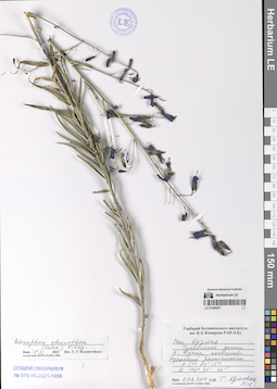
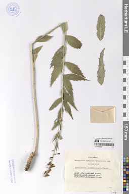
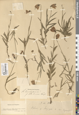
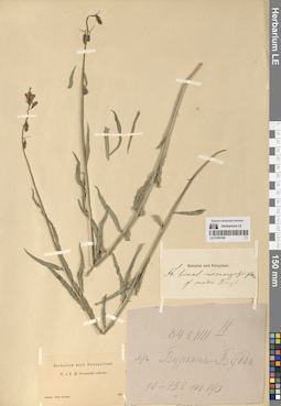
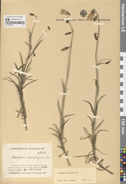
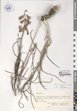
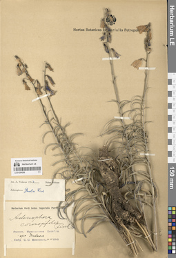
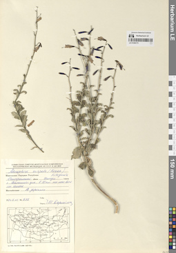
LE 01294291
Adenophora stenanthina (Ledeb.) Kitag. det. Krestovskaya, Tatiana Valerievna at 18.11.2021
Collectors: Krestovskaya, Tatiana Valerievna Collection date: 02.08.2010. Administrative regions: RU - Respublika Buryatiya - Tunkinskiy Rayon. Groups of specimens: Образцы сектора Сибири и Дальнего Востока РоссииOriginal label text:Республика Бурятия. Тункинская долина. Село Тунка, сообщество рудеральной растительности.
Coordinates (geographic position): 51° 44′ 15″ N, 102° 30′ 46″ EComment: N 51° 44' 15"
E 102° 30' 46"
2.08.2010
Т. Крестовская
Republic of Buryatia. Tunkinskaya Valley. Tunka village, ruderal vegetation community.
Record creation: 2024-08-10, Daria Yudova, PhotoScan D2.Citation: Specimen LE 01294291 // Virtual herbarium of Komarov Botanical Institute RAS — http://re.herbariumle.ru/01294291N 51° 44' 15"
E 102° 30' 46"
2.08.2010
Coll. T. Krestovskaya
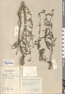
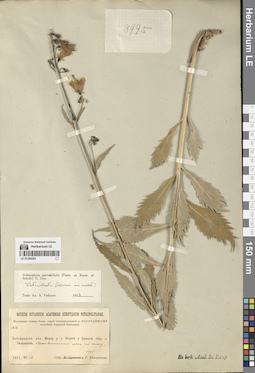
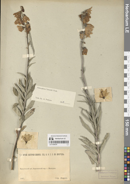
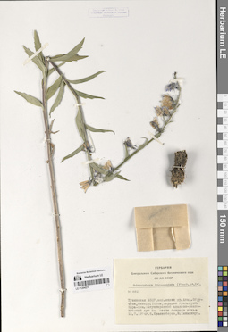
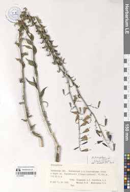
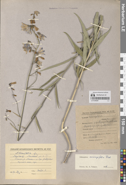
LE 01294196
Adenophora liliifolia (L.) A. DC.
Collection date: 23.08.1898. Groups of specimens: Образцы сектора Центральной и Восточной Азии; Соглашение Минобрнауки №075-15-2021-1056Original label text:Каманское ущелье.
Comment: Монголия
23.VIII.1898
[...]
Kaman Gorge.
Mongolia
23.VIII.1898
[...]
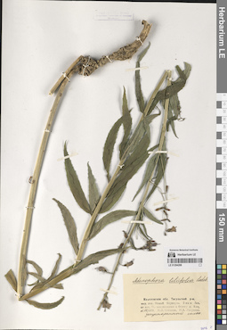
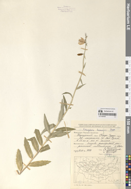
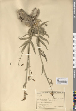
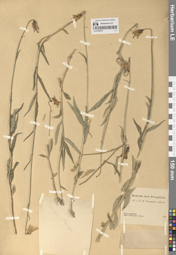
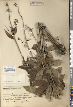
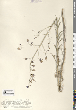
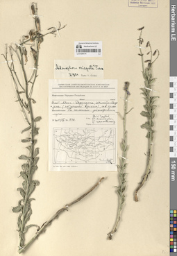
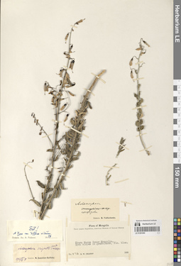
LE 01294290
Adenophora stenanthina (Ledeb.) Kitag. det. Golovina, Ekaterina Olegovna
Collectors: Golovina, Ekaterina Olegovna; Tkachuk, Tatiana Evgenievna Field collecting number: 38. Collection date: 03.08.2004. Administrative regions: RU - Zabaykal'skiy Kray - Kyrinskiy Rayon. Groups of specimens: Образцы сектора Сибири и Дальнего Востока РоссииOriginal label text:Читинская область. Кыринский район. 5 км к ЮВ от поселка Кыра. Улутуйская сопка. Каменистый выступ в верхней части склона. Арктогероново-овсяницевое (Festuca lenensis) петрофитное сообщество.
Coordinates (geographic position): 49° 34′ 13.14″ N, 112° 3′ 23.5″ EComment: 3.08.2004
Ткачук Т. Е., Головина Е. О.
Chita Region. Kyra District. 5 km SE from the Kyra village. Ulutuyskaya Sopka. Rocky ledge in the upper part of the slope. Arctogeron-fescue (Festuca lenensis) petrophytic community.
3.08.2004
Coll. Tkachuk T. E., Golovina E. O.
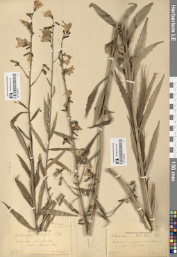
LE 01294195
Adenophora liliifolia (L.) A. DC.
Collectors: Kusnetzoff Collection date: 1855. Administrative regions: JP - Japan. Groups of specimens: Образцы сектора Центральной и Восточной Азии; Соглашение Минобрнауки №075-15-2021-1056Original label text:Simoda, 1855
Coordinates (geographic position): 34° 41′ 5.66″ N, 138° 56′ 58.52″ ERecord creation: 2024-08-09, Daria Yudova, PhotoScan D2.Citation: Specimen LE 01294195 // Virtual herbarium of Komarov Botanical Institute RAS — http://re.herbariumle.ru/01294195Japonia
Kusnetzoff

LE 01294194
Adenophora liliifolia (L.) A. DC.
Collectors: David, Armand Collection date: 08.1862. Groups of specimens: Образцы сектора Центральной и Восточной Азии; Соглашение Минобрнауки №075-15-2021-1056Comment:Environs de Pekin
Record creation: 2024-08-09, Daria Yudova, PhotoScan D2.Citation: Specimen LE 01294194 // Virtual herbarium of Komarov Botanical Institute RAS — http://re.herbariumle.ru/01294194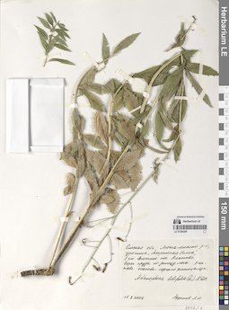
LE 01294289
Adenophora liliifolia (L.) A. DC.
Collectors: Efremov, Andrey Nikolaevich Collection date: 15.08.2006. Administrative regions: RU - Omskaya Oblast' - Poltavskiy Rayon. Groups of specimens: Образцы сектора Сибири и Дальнего Востока РоссииOriginal label text:Омская область, Москаленский район, урочище "Амринская балка", 8 км восточнее поселка Платово. Берег пруда по днищу лога. В составе осоково-горцего фитоценоза.
Coordinates (geographic position): 54° 31′ 51.23″ N, 71° 47′ 3.32″ EComment: 15.8.2006
Ефремов А. Н.
Omsk Region, Moskalensky District, "Amrinskaya Balka", 8 km east of the Platovo village.
Record creation: 2024-08-10, Daria Yudova, PhotoScan D2.Citation: Specimen LE 01294289 // Virtual herbarium of Komarov Botanical Institute RAS — http://re.herbariumle.ru/0129428915.8.2006
Coll. A. N. Efremov
LE 01294193
Adenophora liliifolia (L.) A. DC.
Field collecting number: 908. Collection date: 1951. Administrative regions: CN - China. Groups of specimens: Образцы сектора Центральной и Восточной Азии; Соглашение Минобрнауки №075-15-2021-1056Original label text:КНР, провинция Ляонин, город Люшунь (Порт-Артур), гора Байюйшань.
Comment: 40-100 м.
№ 908
1951
Wang Chang, Liou Ying-hsin, Li Shu-hsin, Fuh Pei-yun.
China, Liaoning province, Lushun city (Port Arthur), Baiyushan mountain.
40-100 m.
No. 908
1951
Wang Chang, Liou Ying-hsin, Li Shu-hsin, Fuh Pei-yun.
LE 01294288
Adenophora liliifolia (L.) A. DC.
Collectors: Olonova, Marina Vladimirovna; Lagunova N. A. Collection date: 10.07.1978. Administrative regions: RU - Kemerovskaya Oblast' - Tisul'skiy Rayon. Groups of specimens: Образцы сектора Сибири и Дальнего Востока РоссииOriginal label text:Кемеровская область, Тисульский район, окрестности поселка Новый Берикуль, 2 км к западу от поселка. По направлению к реке Кии, закустаренный склон.
Coordinates (geographic position): 55° 29′ 44.62″ N, 88° 4′ 46.93″ EComment: 10.07.1978
М. В. Олонова, Н. А. Лагунова
Kemerovo Region, Tisulsky District, outskirts of the Novy Berikul village, 2 km west of the village. Towards the Kiya River, a bushy slope. 10.07.1978 M. V. Olonova, N. A. Lagunova
LE 01294191
Adenophora liliifolia (L.) A. DC.
Collectors: Komarov, Vladimir Leontjevich Collection date: 17.07.1897. Administrative regions: CN - China. Groups of specimens: Образцы сектора Центральной и Восточной Азии; Соглашение Минобрнауки №075-15-2021-1056Original label text:Манджурия. Область охотников.
Comment: Склоны гор с дубняком. Долина верхнего Ялу.
17.VII.1897
В. Комаров
Manchuria. Hunters' Region.
Mountain slopes with oak forest. Upper Yalu Valley.
17.07.1897
V. Komarov

LE 01294192
Adenophora liliifolia (L.) A. DC.
Collectors: Komarov, Vladimir Leontjevich Collection date: 21.08.1897. Groups of specimens: Образцы сектора Центральной и Восточной Азии; Соглашение Минобрнауки №075-15-2021-1056Original label text:Корея. Кустарные заросли по склонам у города Ху-чана.
Comment: 21.VIII.1897
В. Комаров
Korea. Shrub thickets on the slopes near the city of Hu-chan.
21.08.1897
V. Komarov
LE 01294287
Adenophora liliifolia (L.) A. DC.
Collectors: Vandakurova, E. V. Collection date: 22.07.1951. Administrative regions: RU - Respublika Altay - Chemal'skiy Rayon. Groups of specimens: Образцы сектора Сибири и Дальнего Востока РоссииOriginal label text:Алтай, Онгудайский аймак. Окрестности деревни Ороктой. Лесной луг.
22.7.1951Е. Вандакурова
Altai, Ongudai aimak. The outskirts of the Oroktoy village. Forest meadow.
Record creation: 2024-08-10, Daria Yudova, PhotoScan D2.Citation: Specimen LE 01294287 // Virtual herbarium of Komarov Botanical Institute RAS — http://re.herbariumle.ru/0129428722.07.1951
Coll. E. Vandakurova
LE 01294190
Adenophora liliifolia (L.) A. DC. det. Grubov, Valery Ivanovich
Collectors: Grubov, Valery Ivanovich; Darijma, Sh.; Ulziykhutag, Nadmidyn Field collecting number: 841. Collection date: 17.07.1971. Administrative regions: MN - Mongolia. Groups of specimens: Образцы сектора Центральной и Восточной Азии; Соглашение Минобрнауки №075-15-2021-1056Original label text:Монгольская Народная Республика. Северо-Запад; хребет Тургэнь, долина Тургэнь-гола в 7 км выше устья, правобережный склон за первой падью (северная экспозиция). Лиственничник травяной.
Comment: № 841
7.VII.1971
В. Грубов, Н. Ульзихутаг, Ш. Дарийма
Mongolia. Northwest; Turgen Ridge, Turgen-gol Valley 7 km above the mouth, right-bank slope beyond the first gorge (northern exposure).
№ 841
7.07.1971
V. Grubov, N. Ulzikhutag, Sh. Dariima
LE 01294286
Adenophora liliifolia (L.) A. DC.
Collection date: 25.07.1944. Administrative regions: RU - Respublika Khakasiya. Groups of specimens: Образцы сектора Сибири и Дальнего Востока РоссииOriginal label text:Красноярский край, Усть-Абаканский район. В 6 км восточнее села Усть-Бирь. Северный склон. Разреженный лиственничный лес.
Coordinates (geographic position): 53° 49′ 27.28″ N, 90° 20′ 4″ EComment: 25.7.1944
К. Соболевская, Степанченко
Krasnoyarsk Krai, Ust-Abakansky District. 6 km east of the Ust-Bir village. Northern slope. Sparse larch forest.
Record creation: 2024-08-10, Daria Yudova, PhotoScan D2.Citation: Specimen LE 01294286 // Virtual herbarium of Komarov Botanical Institute RAS — http://re.herbariumle.ru/0129428625.07.1944
Coll. K. Sobolevskaja, Stepanchenko
LE 01294189
Adenophora liliifolia (L.) A. DC. det. Fedorov, Andrey Aleksandrovich at 1954
Collectors: Fetissow, A. Collection date: 20.07.1877. Administrative regions: CN - China. Groups of specimens: Образцы сектора Центральной и Восточной Азии; Соглашение Минобрнауки №075-15-2021-1056Original label text:westl. v. Sairam-See
Comment: (n. o. Kuldscha)
20.VII.77
leg. Fetissow
Vicinity of the Sairam lake
Record creation: 2024-08-09, Daria Yudova, PhotoScan D2.Citation: Specimen LE 01294189 // Virtual herbarium of Komarov Botanical Institute RAS — http://re.herbariumle.ru/01294189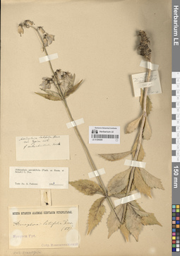
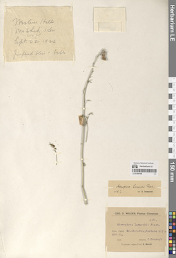
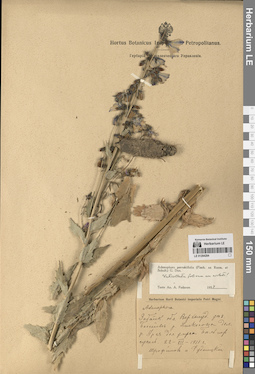
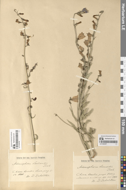
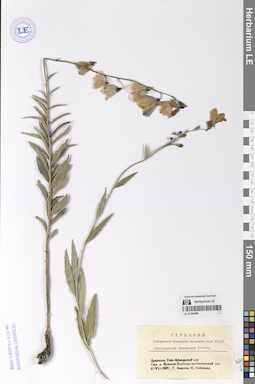
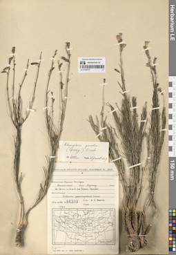
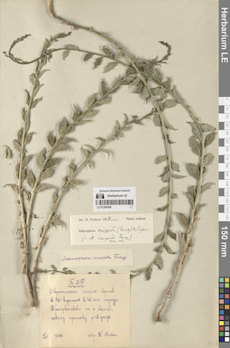
LE 01294285
Adenophora pereskiifolia (Fisch. ex Roem. & Schult.) G. Don det. Fedorov, Andrey Aleksandrovich at 1954
Collectors: Ksenzhopolsky (Księżpolski), Wladislav Thomasz Field collecting number: 383. Collection date: 13.07.1878. Administrative regions: RU - Respublika Buryatiya - Tunkinskiy Rayon. Groups of specimens: Образцы сектора Сибири и Дальнего Востока РоссииOriginal label text:1) Иркутская губерния.
Coordinates (geographic position): 51° 49′ 30.33″ N, 102° 29′ 20.63″ EComment: Собр. Ксенжопольский
2) № 383
Село Култук. Дорога на Хамар-дабан. Гора Тальская.
13.VII.78
1) Irkutsk province.
Record creation: 2024-08-10, Daria Yudova, PhotoScan D2.Citation: Specimen LE 01294285 // Virtual herbarium of Komarov Botanical Institute RAS — http://re.herbariumle.ru/01294285Coll. Ksenzhopolsky
2) Kultuk village. Road to Khamar-Daban. Mount Talskaya.
13.07.1878
LE 01294188
Adenophora lamarckii Fisch. det. Juzepczuk, Sergei Vasilievich at 01.1925
Field collecting number: 87. Collection date: 22.09.1923. Administrative regions: CN - China. Groups of specimens: Образцы сектора Центральной и Восточной Азии; Соглашение Минобрнауки №075-15-2021-1056Original label text:№ 87.
Record creation: 2024-08-09, Daria Yudova, PhotoScan D2.Citation: Specimen LE 01294188 // Virtual herbarium of Komarov Botanical Institute RAS — http://re.herbariumle.ru/01294188Prov. Chihli. Mo-Shih-Kou, Western hills, 600 ft.
22 Sept. 1923
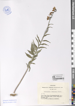
LE 01294284
Adenophora pereskiifolia (Fisch. ex Roem. & Schult.) G. Don det. Fedorov, Andrey Aleksandrovich at 1954
Collectors: Trofimow, E.Ph.; Rudnitsky V. E. Collection date: 22.07.1911. Administrative regions: RU - Zabaykal'skiy Kray - Khilokskiy Rayon. Groups of specimens: Образцы сектора Сибири и Дальнего Востока РоссииOriginal label text:Забайкальская область, Верхнеудинский уезд. Бассейн реки Хилкосона, долина реки Арея, долина улуса Бельчир. Супесь
Coordinates (geographic position): 51° 2′ 0.25″ N, 110° 35′ 51.88″ EComment: 22.VII.1911
Трофимов и Рудницкий
Zabaikalsky region, Verkhneudinsky district. Khilkoson river basin, Arey river valley, Belchir ulus valley.
Record creation: 2024-08-10, Daria Yudova, PhotoScan D2.Citation: Specimen LE 01294284 // Virtual herbarium of Komarov Botanical Institute RAS — http://re.herbariumle.ru/0129428422.07.1911
Coll. Trofimow, Rudnitsky
LE 01294187
Adenophora lamarckii Fisch.
Collection date: 30.08.1898. Groups of specimens: Образцы сектора Центральной и Восточной Азии; Соглашение Минобрнауки №075-15-2021-1056Original label text:China borealis, prope Peking.
Record creation: 2024-08-09, Daria Yudova, PhotoScan D2.Citation: Specimen LE 01294187 // Virtual herbarium of Komarov Botanical Institute RAS — http://re.herbariumle.ru/01294187Мирские кладбища [= Cemeteries].
30.VIII.1898
Dr. D. Zabolotnoi

LE 01294186
Adenophora lamarckii Fisch.
Collection date: 05.09.1898. Administrative regions: CN - China. Groups of specimens: Образцы сектора Центральной и Восточной Азии; Соглашение Минобрнауки №075-15-2021-1056Original label text:China borealis. Luan ping.
Record creation: 2024-08-09, Daria Yudova, PhotoScan D2.Citation: Specimen LE 01294186 // Virtual herbarium of Komarov Botanical Institute RAS — http://re.herbariumle.ru/012941865.IX.1898
Dr. D. Zabolonoi
LE 01294283
Adenophora pereskiifolia (Fisch. ex Roem. & Schult.) G. Don det. Fedorov, Andrey Aleksandrovich at 1954
Collectors: Poplavskaya (Poplawska), Henrietta Ippolitovna Collection date: 10.07.1911. Administrative regions: RU - Zabaykal'skiy Kray - Nerchinskiy Rayon. Groups of specimens: Образцы сектора Сибири и Дальнего Востока РоссииOriginal label text:Забайкальская область. Между реками Нерчей и Куенгой. Окрестности села Зюльзакана. Лиственничный лес по склону.
Coordinates (geographic position): 52° 41′ 20.94″ N, 116° 18′ 42.93″ EComment: 10.VII.1911
Г. Поплавская
Transbaikal region. Between the rivers Nercha and Kuenga. The outskirts of the Zyulzakan village. Larch forest on the slope.
Record creation: 2024-08-10, Daria Yudova, PhotoScan D2.Citation: Specimen LE 01294283 // Virtual herbarium of Komarov Botanical Institute RAS — http://re.herbariumle.ru/0129428310.07.1911
Coll. G. Poplavskaya
LE 01294185
Adenophora lamarckii Fisch.
Field collecting number: 4929. Collection date: 23.08.1973. Administrative regions: MN - Mongolia. Groups of specimens: Образцы сектора Центральной и Восточной Азии; Соглашение Минобрнауки №075-15-2021-1056Original label text:Монгольская Народная Республика
Comment: Убсунурский аймак, Барун-Турун сомон. Северный макросклон хребта Хан-Хухэй в 32 км к ЮЗ от сомона. Злаково-разнотравный разреженный лиственничник. h= 1700 м.
№ 4929
23.VII.1973
Д. Банзрагч, З. В. Карамышева, С. Мунхбаяр, Ц. Цэглинд
Mongolia
Ubsunur aimak, Barun-Turun somon. The northern macroslope of the Khan-Khuhei ridge is 32 km southwest of the somon. h= 1700 m.
No. 4929
23.VII.1973
D. Banzragch, Z. V. Karamysheva, S. Munkhbayar, Ts. Tseglind
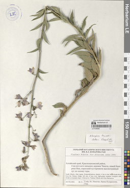
LE 01294282
Adenophora lamarckii Fisch. det. Knjazev, Mikhail Sergeyevich at 2019
Collectors: Nikitin V.; Illarionova, Irina Dmitrievna Field collecting number: 21. Collection date: 28.07.2001. Administrative regions: RU - Altayskiy Kray - Krasnoshchekovskiy Rayon. Groups of specimens: Образцы сектора Сибири и Дальнего Востока РоссииOriginal label text:Алтайский край, Краснощековский район, 4 км юго-юго-западнее деревни Чинета, левый берег реки Ини, поросший кустарником высокотравный луг по склону горы.
Coordinates (geographic position): 51° 17′ 54.76″ N, 83° 2′ 35.33″ EComment: № 21
28.VII.2001
В. Никитин, Ирина Илларионова
South Siberia, Altai region, Krasnoshchekovo district, 4 km to the South-South-West from the Chineta village, left side of Inya river, high-grassy meadow overgrew with shrubs on mountain slope
Record creation: 2024-08-10, Daria Yudova, PhotoScan D2.Citation: Specimen LE 01294282 // Virtual herbarium of Komarov Botanical Institute RAS — http://re.herbariumle.ru/0129428228.07.2001
Coll. V. Nikitin, I. Illarionova
LE 01294184
Adenophora himalayana Feer
Collectors: Roborovsky, Vsevolod Ivanovich Field collecting number: 167. Collection date: 1890. Administrative regions: CN - China. Groups of specimens: Образцы сектора Центральной и Восточной Азии; Соглашение Минобрнауки №075-15-2021-1056Original label text:Pl. a W. J. Roborowski collectae.
Comment: (Kaschgaria et Tibet. 1890).
Kuen-Lun. Северный склон хребта Гумбольдта, ущелье Чансай. 9-10000'. На лугу. Цветки синие.
Pl. a W. J. Roborowski collectae.
Record creation: 2024-08-09, Daria Yudova, PhotoScan D2.Citation: Specimen LE 01294184 // Virtual herbarium of Komarov Botanical Institute RAS — http://re.herbariumle.ru/01294184(Kaschgaria et Tibet. 1890).
Kuen-Lun. Northern slope of the Humboldt ridge, Chansay gorge. 9-10000'. In the meadow. Blue flowers.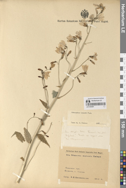
LE 01294281
Adenophora lamarckii Fisch. det. Fedorov, Andrey Aleksandrovich at 1954
Collectors: Емельянцева, В. Collection date: 03.08.1912. Administrative regions: RU - Tomskaya Oblast'. Groups of specimens: Образцы сектора Сибири и Дальнего Востока РоссииOriginal label text:1) 3го августа 1912 г. [...] "Городок". [...] на опушке леса.
Coordinates (geographic position): 56° 55′ 0.67″ N, 86° 38′ 23.95″ EComment: Соб. В. Емельянцева
2) Томская губ. Окрестности города Томска.
Собр. В. И. Емельянцева 1912 г.
1) August 3, 1912 [...] "Gorodok". [...] on the edge of the forest.
Coll. V. Yemelyantseva
2) Tomsk province. Environs of the city of Tomsk.
Coll. V. I. Yemelyantseva 1912
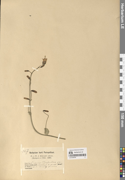
LE 01294183
Adenophora himalayana Feer
Collectors: V.O. Ladygin Field collecting number: 307. Collection date: 25.07.1901. Administrative regions: CN - China. Expedition: Экспедиция П.К. Козлова в Центральную Азию (1899)Groups of specimens: Образцы сектора Центральной и Восточной Азии; Соглашение Минобрнауки №075-15-2021-1056Original label text:№ 307
Comment: Цветки светло-синие; на сухих, каменистых скалах ущелья.
Хребет Бурхан-Будда:
Северный склон. Ущелье Хату.
Высота 10500 фут. а.в.
1901 г. 25 июля
В. О. Ладыгин
Flowers are light blue; on dry, rocky cliffs of the gorge. Burkhan-Buddha Ridge: Northern slope. Khatu Gorge. Height 10,500 ft. a.w.
Record creation: 2024-08-09, Daria Yudova, PhotoScan D2.Citation: Specimen LE 01294183 // Virtual herbarium of Komarov Botanical Institute RAS — http://re.herbariumle.ru/01294183№ 307
25.07.1901
Coll. V.O. Ladygin
LE 01294280
Adenophora lamarckii Fisch.
Collectors: Zvereva, G.; Neyfeld, I. Collection date: 27.07.1967. Administrative regions: RU - Respublika Khakasiya. Groups of specimens: Образцы сектора Сибири и Дальнего Востока РоссииOriginal label text:Хакассия. Усть-Абаканский район. Окрестности деревни Камызяк. Березово-лиственничный лес.
Coordinates (geographic position): 53° 51′ 12.07″ N, 90° 36′ 7.57″ EComment: 27.VII.1967
Г. Зверева, И. Нейфельд
Khakassia. Ust-Abakansky district. Vicinity of the village of Kamyzyak. Birch-larch forest.
Record creation: 2024-08-10, Daria Yudova, PhotoScan D2.Citation: Specimen LE 01294280 // Virtual herbarium of Komarov Botanical Institute RAS — http://re.herbariumle.ru/0129428027.07.1967
Coll. G. Zvereva, I. Neyfeld
LE 01294279
Adenophora lamarckii Fisch.
Collectors: Shaulo Dmitry Nikolaevich; Shuvaev, V. Field collecting number: 840. Collection date: 13.07.1978. Administrative regions: RU - Respublika Tyva. Groups of specimens: Образцы сектора Сибири и Дальнего Востока РоссииOriginal label text:Тува, Западный Саян, Куртушибинский хребет, долина реки Стерлик, высота 1160 м. Закустаренный луг.
Coordinates (geographic position): 52° 26′ 42.46″ N, 93° 50′ 14.36″ EComment: 13.07.1978
Д. Шауло, В. Шуваев
Tuva, Western Sayan, Kurtushibinsky ridge, Sterlik river valley, altitude 1160 m. Shrubbed meadow.
13.07.1978
Coll. D. Shaulo, V. Shuvaev
LE 01294182
Adenophora himalayana Feer
Collectors: Potanin, Grigorii Nikolajevic Collection date: 09.08.1885. Administrative regions: CN - China. Groups of specimens: Образцы сектора Центральной и Восточной Азии; Соглашение Минобрнауки №075-15-2021-1056Original label text:1) China borealis: prov. Tschili, Schansi, Kansu occidentali et orientali et Szetschuan septentrionali.
Comment: G. N. Potanin. 1884. 1885
2) 9 авг. 1885
Долина реки Ату-лунва в ее вершине.
1) China borealis: prov. Tschili, Schansi, Kansu occidentali et orientali et Szetschuan septentrionali.
2) 9 Aug 1885 The valley of the Atu-lunva River at its summit.
Record creation: 2024-08-09, Daria Yudova, PhotoScan D2.Citation: Specimen LE 01294182 // Virtual herbarium of Komarov Botanical Institute RAS — http://re.herbariumle.ru/01294182G. N. Potanin. 1884. 1885
LE 01294278
Adenophora lamarckii Fisch. det. Fedorov, Andrey Aleksandrovich at 1954
Collectors: Petrof Collection date: 1881. Administrative regions: RU - Irkutskaya Oblast'. Groups of specimens: Образцы сектора Сибири и Дальнего Востока РоссииOriginal label text:Иркутской губ. Верхоленский окр. с. Манзурка.
Coordinates (geographic position): 53° 29′ 3.98″ N, 106° 4′ 32.66″ EComment: 1881
Собр. Петров
Irkutsk region, the outskirts of the village of Manzurka.
Record creation: 2024-08-10, Daria Yudova, PhotoScan D2.Citation: Specimen LE 01294278 // Virtual herbarium of Komarov Botanical Institute RAS — http://re.herbariumle.ru/012942781881
Coll. Petrov
LE 01294181
Adenophora himalayana Feer
Collectors: Przhevalski, Nikolai Mikhailovich Field collecting number: 523. Collection date: 12.07.1880. Administrative regions: CN - China. Groups of specimens: Образцы сектора Центральной и Восточной Азии; Соглашение Минобрнауки №075-15-2021-1056; Pl. a N.M. Przewalski collectaeOriginal label text:1) Pl. a N.M. Przewalski collectae
Coordinates (geographic position): 36° 47′ 46.23″ N, 99° 45′ 13.06″ ERecord creation: 2024-08-09, Daria Yudova, PhotoScan D2.Citation: Specimen LE 01294181 // Virtual herbarium of Komarov Botanical Institute RAS — http://re.herbariumle.ru/01294181China occidentalis.
Regio Tangut (prov. Kansu).
1880
2) 12.VII.80
Kuku, Kansu
LE 01294277
Adenophora tricuspidata (Fisch. ex Roem. & Schult.) A. DC. det. Maksimov, M.I.
Collectors: Maksimov, M.I. Collection date: 10.08.1964. Administrative regions: RU - Respublika Buryatiya. Groups of specimens: Образцы сектора Сибири и Дальнего Востока РоссииOriginal label text:Хэнтэй-Чикойское нагорье. Бассейн реки Чикой, каменистые степи в окрестностях села Тамир.
Coordinates (geographic position): 50° 15′ 30.82″ N, 107° 30′ 3.28″ EComment: 10.VIII.1964
Максимов М. И.
Khentei-Chikoy Highlands. Chikoy River basin, rocky steppes in the vicinity of the village of Tamir.
Record creation: 2024-08-10, Daria Yudova, PhotoScan D2.Citation: Specimen LE 01294277 // Virtual herbarium of Komarov Botanical Institute RAS — http://re.herbariumle.ru/0129427710.08.1964
Coll. M.I. Maksimov
LE 01294180
Adenophora himalayana Feer
Collectors: Przhevalski, Nikolai Mikhailovich Collection date: 01.08.1884. Administrative regions: CN - China. Groups of specimens: Образцы сектора Центральной и Восточной Азии; Соглашение Минобрнауки №075-15-2021-1056; Pl. a N.M. Przewalski collectaeOriginal label text:1) Pl. a N.M. Przewalski collectae
Coordinates (geographic position): 37° 45′ 0″ N, 97° 0′ 0″ EComment: Zaidam, Tibet borealis.
1884
2) 1-2.VIII.84
Хр. Бурхан-Будда
10-15,5 т. ф
1) Pl. a N.M. Przewalski collectae
Record creation: 2024-08-09, Daria Yudova, PhotoScan D2.Citation: Specimen LE 01294180 // Virtual herbarium of Komarov Botanical Institute RAS — http://re.herbariumle.ru/01294180Zaidam, Tibet borealis.
1884
2) 1-2.VIII.84
Burkhan Buddha Ridge
LE 01294276
Adenophora liliifolia (L.) A. DC. det. Popov, Mikhail Grigorevich (Popow)
Collectors: Held, A.I. Collection date: 19.08.1952. Administrative regions: RU - Irkutskaya Oblast' - Bratskiy Rayon. Groups of specimens: Образцы сектора Сибири и Дальнего Востока РоссииOriginal label text:Иркутская область, Братский район, окрестности села Анзёбы. Юго-восточный склон к долине реки Вихаревки.
Coordinates (geographic position): 56° 9′ 29.72″ N, 101° 28′ 23.73″ EComment: 19.VIII.1952
А. И. Гельд
Irkutsk region, Bratsk district, vicinity of the village of Anzeby. South-eastern slope to the valley of the Vikharevka river.
Record creation: 2024-08-10, Daria Yudova, PhotoScan D2.Citation: Specimen LE 01294276 // Virtual herbarium of Komarov Botanical Institute RAS — http://re.herbariumle.ru/0129427619.08.1952
Coll. A.I. Held
LE 01294179
Adenophora himalayana Feer det. Krestovskaya, Tatiana Valerievna at 2000
Field collecting number: 1512. Collection date: 24.08.1957. Administrative regions: CN - China. Expedition: Синьцзянская Комплексная Экспедиция Академии Наук Китайской Народной Республики. Ботанический отряд (1956 -1959)Groups of specimens: Образцы сектора Центральной и Восточной Азии; Соглашение Минобрнауки №075-15-2021-1056Original label text:Китайская Народная Республика. Синьдзян-Уйгурская автономная область.
Comment: Восточный Тянь-Шань, Илийская долина. Правый борт долины верхнего Текеса. В 7-8 км ЮВ поселка Аксу. Северный склон гор. Пояс ельников. Ельник травяной.
№ 1512
24.08.1957
А. А. Юнатов, Ли Ши-ин, Юань И-фэнь.
People's Republic of China. Xinjiang Uyghur Autonomous Region.
Eastern Tien Shan, Ili Valley. Right side of the Upper Tekes Valley. 7-8 km SE of Aksu village. Northern slope of the mountains. Spruce belt. Grassy spruce forest.
№ 1512
24.08.1957
Coll. A. A. Yunatov, Li Shi-ying, Yuan Yi-fen.
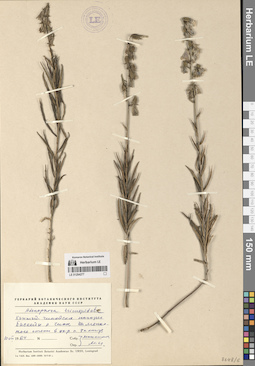
LE 01294275
Adenophora tricuspidata (Fisch. ex Roem. & Schult.) A. DC.
Collectors: Zvereva, G.; Alekseeva, N. M. Collection date: 27.07.1966. Administrative regions: RU - Respublika Khakasiya. Groups of specimens: Образцы сектора Сибири и Дальнего Востока РоссииOriginal label text:Хакассия. Ширинский район.
Coordinates (geographic position): 54° 28′ 11.1″ N, 90° 22′ 4.97″ EComment: Окрестности ц у "Борец". Луг.
27.VII.1966
Г. Зверева, Н. Алексеева
Khakassia. Shirinsky district. Vicinity of the village Borets. Meadow.
Record creation: 2024-08-10, Daria Yudova, PhotoScan D2.Citation: Specimen LE 01294275 // Virtual herbarium of Komarov Botanical Institute RAS — http://re.herbariumle.ru/0129427527.07.1966
Coll. G. Zvereva, N. Alekseeva
LE 01294178
Adenophora himalayana Feer det. Fedorov, Andrey Aleksandrovich at 1954
Collectors: Merzbacher, G. Field collecting number: 962. Collection date: 11.08.1907. Groups of specimens: Образцы сектора Центральной и Восточной Азии; Соглашение Минобрнауки №075-15-2021-1056Original label text:G. Merzbacher: Iter Tianschanicum 1907
Record creation: 2024-08-09, Daria Yudova, PhotoScan D2.Citation: Specimen LE 01294178 // Virtual herbarium of Komarov Botanical Institute RAS — http://re.herbariumle.ru/01294178№ 962
Turkestania chinensis: declivitas septentrionalis jugi montium Tianschan orient. (Tekes, Agias etc.) Mittleres und unteres Agias Tal
11-20.VIII [1907]
LE 01294274
Adenophora tricuspidata (Fisch. ex Roem. & Schult.) A. DC.
Collectors: Krasnoborov, Ivan Moiseevich; Khanminchun, Valerij Mikhailovich Field collecting number: 882. Collection date: 15.07.1974. Administrative regions: RU - Respublika Tyva. Groups of specimens: Образцы сектора Сибири и Дальнего Востока РоссииOriginal label text:№ 882
Coordinates (geographic position): 52° 0′ 8.33″ N, 95° 15′ 44.17″ EComment: Тувинская ААСР, западный склон хребта Академика Обручева, бассейн реки Тапса, верхний ее правый приток Кара-Хем.Закустаренный злаково-разнотравный луг на месте бывшего жилья.
15.7.1974
И. Красноборов, В. Ханминчун
№ 882
Record creation: 2024-08-10, Daria Yudova, PhotoScan D2.Citation: Specimen LE 01294274 // Virtual herbarium of Komarov Botanical Institute RAS — http://re.herbariumle.ru/01294274Republic of Tyva, Western slope of the Academician Obruchev ridge, the Tapsa River basin, its upper right tributary Kara-Khem. A bushy grass-forb meadow on the site of a former dwelling.
15.07.1974
Coll. I. Krasnoborov, V. Khanminchun
LE 01294273
Adenophora tetraphylla (Thunb.) Fisch. det. Fedorov, Andrey Aleksandrovich at 1965
Collection date: 19.07.1956. Administrative regions: RU - Zabaykal'skiy Kray. Groups of specimens: Образцы сектора Сибири и Дальнего Востока РоссииOriginal label text:Читинская область. Нерчинско-заводской район. Северный склон сопки у водораздела падей Грязной и Сенной близ Нерчинского завода.
Coordinates (geographic position): 51° 17′ 4.28″ N, 119° 39′ 51.03″ EComment: 19.VII.1956
Р. Т. Яцурина
Chita region. Nerchinsko-zavodskoy district. Northern slope of the hill at the watershed of the Gryaznaya and Sennaya gorges near the Nerchinsky Zavod.
19.07.1956
Coll. R. T. Yatsurina
LE 01294177
Adenophora gmelinii (Spreng.) Fisch.
Collectors: Potanin, Grigorii Nikolajevic; Soldatov, V.V. Collection date: 05.07.1899. Administrative regions: CN - China. Groups of specimens: Образцы сектора Центральной и Восточной Азии; Соглашение Минобрнауки №075-15-2021-1056Original label text:Кулун-буир-[...]орская равнина.
Coordinates (geographic position): 46° 4′ 17.25″ N, 118° 45′ 21.75″ EComment: Между рекой Ульгин-гол и озером Лыксэ.
5 июля 1899 г.
Собрали Потанин и Солдатов.
Khulun-buir-[...] plain.
Record creation: 2024-08-09, Daria Yudova, PhotoScan D2.Citation: Specimen LE 01294177 // Virtual herbarium of Komarov Botanical Institute RAS — http://re.herbariumle.ru/01294177Between the Ulgin-gol River and Lake Lykse.
5.07.1899
Coll. G. Potanin, V. Soldatov
LE 01294270
Adenophora gmelinii (Spreng.) Fisch. det. Knjazev, Mikhail Sergeyevich at 2019
Collectors: Budantsev, Andrey Lvovich; Korobkov, Aleksandr Aleksandrovich; Mokhova, I.I.; Medvedeva, Nina Anatolyevna Field collecting number: 59. Collection date: 03.08.1995. Administrative regions: RU - Zabaykal'skiy Kray. Groups of specimens: Образцы сектора Сибири и Дальнего Востока РоссииOriginal label text:Читинская область, Агинский-Бурятский АО, долина реки Ага, каменистые склоны к югу от села Ага, 51,10 с.ш., 115,10 в.д.
Coordinates (geographic position): 51° 10′ 21.9″ N, 115° 11′ 22.22″ EComment: № 59
3.08.1995
Буданцев А. Л., Коробков А. А., Мохова И. И., Медведева Н. А.
Chita region, Aginsky-Buryat Autonomous Okrug, Aga River valley, rocky slopes to the south of the village of Aga, 51.10 N, 115.10 E.
№ 59
3.08.1995
Coll. Budantsev A.L., Korobkov A.A., Mokhova I.I., Medvedeva N.A.
LE 01294176
Adenophora gmelinii (Spreng.) Fisch.
Collectors: Gubanov, Ivan Alekseevich; Darijma, Sh.; Ganbold, E.; Kamelin, Rudolph Vladimirovich; Budantsev, Andrey Lvovich Field collecting number: 2488. Collection date: 03.08.1987. Administrative regions: MN - Mongolia. Groups of specimens: Образцы сектора Центральной и Восточной Азии; Соглашение Минобрнауки №075-15-2021-1056Original label text:МНР. Хэнтэйский аймак. 48° 50' с.ш. 111° 50' в.д. Хребет Эрэн-Даба. 15 км на СВ от переправы через реку Онон на Дадал, между высотой 1360 м и вершиной Олон-Обо (1348 м). 1300-1320 м н.у.м. Сосняк.
Coordinates (geographic position): 48° 50′ 0″ N, 111° 50′ 0″ EComment: № 2488
3.VIII.1987
И. А. Губанов, Ш. Дариймаа, Э. Ганболд, Р. В. Камелин, А. Л. Буданцев
Mongolia. Khentei aimag. 48° 50' N 111° 50'E Eren-Daba Ridge. 15 km to the NE from the crossing of the Onon River to Dadal, between an altitude of 1360 m and the peak of Olon-Obo (1348 m). 1300-1320 m above sea level Pine forest.
Record creation: 2024-08-09, Daria Yudova, PhotoScan D2.Citation: Specimen LE 01294176 // Virtual herbarium of Komarov Botanical Institute RAS — http://re.herbariumle.ru/01294176№ 2488
3.08.1987
Coll. I. A. Gubanov, Sh. Darijma, E. Ganbold, R. V. Kamelin, A. L. Budantsev
LE 01294269
Adenophora gmelinii (Spreng.) Fisch. det. Fedorov, Andrey Aleksandrovich at 1954
Collectors: Arndt, P. Collection date: 07.06.1910. Administrative regions: RU - Zabaykal'skiy Kray - Khilokskiy Rayon. Groups of specimens: Образцы сектора Сибири и Дальнего Востока РоссииOriginal label text:Забайкальская область. Верхнеудинский уезд. Лево-Хилокская лесная дача. Деревня Блудная [= Хилогосон?]. Бор.
Coordinates (geographic position): 51° 9′ 1.84″ N, 110° 38′ 23.65″ EComment: 7.VI.1910
П. Арндт
Transbaikal region. Verkhneudinsk district. Levo-Khilok forest dacha. Village Bludnaya [= Khilogoson?]. Bor.
Record creation: 2024-08-10, Daria Yudova, PhotoScan D2.Citation: Specimen LE 01294269 // Virtual herbarium of Komarov Botanical Institute RAS — http://re.herbariumle.ru/012942697.06.1910
Coll. P. Arndt
LE 01294175
Adenophora gmelinii (Spreng.) Fisch. det. Krestovskaya, Tatiana Valerievna at 2001
Collectors: Yunatov, Alexander Afanasievich Field collecting number: 16303. Collection date: 06.08.1949. Administrative regions: MN - Mongolia. Groups of specimens: Образцы сектора Центральной и Восточной Азии; Соглашение Минобрнауки №075-15-2021-1056Original label text:Монгольская Народная Республика.
Comment: Восточный аймак, Хунту сомон.
В 30 км к ВЮВ от Баин-Цаган. Ковыльно-разнотравная степь.
№ 16303
6.VIII.1949
А. А. Юнатов
Mongolia. Eastern aimag, Khuntu somon.
30 km to the east-southeast of Bain-Tsagan. Feather-grass and mixed-grass steppe.№ 16303
6.08.1949
Coll. A. A. Yunatov
LE 01294268
Adenophora gmelinii (Spreng.) Fisch. det. Fedorov, Andrey Aleksandrovich at 1954
Collectors: Kononov, S.S. Collection date: 10.06.1910. Administrative regions: RU - Krasnoyarskiy Kray. Groups of specimens: Образцы сектора Сибири и Дальнего Востока РоссииOriginal label text:Окрестности Красноярска, Базайха. Гора Диван.
Coordinates (geographic position): 55° 58′ 23.13″ N, 92° 48′ 42.5″ EComment: 10.VI.1910
С. С. Кононов
The environs of Krasnoyarsk, Bazaikha. Mount Divan.
Record creation: 2024-08-10, Daria Yudova, PhotoScan D2.Citation: Specimen LE 01294268 // Virtual herbarium of Komarov Botanical Institute RAS — http://re.herbariumle.ru/0129426810.06.1910
Coll. S.S. Kononov
LE 01294267
Adenophora crispata (Turcz. ex Kitag.) Kitag. det. Knjazev, Mikhail Sergeyevich at 2019
Collectors: Budantsev, Andrey Lvovich; Korobkov, Aleksandr Aleksandrovich; Mokhova, I.I.; Medvedeva, Nina Anatolyevna Field collecting number: 226. Collection date: 10.08.1995. Administrative regions: RU - Zabaykal'skiy Kray - Borzinskiy Rayon. Groups of specimens: Образцы сектора Сибири и Дальнего Востока РоссииOriginal label text:Читинская область, Борзинский район, солончаковые степи и берег озера Борзинского (горько-соленое). 50,20 с.ш., 116,20 в.д.
Coordinates (geographic position): 50° 14′ 50.43″ N, 116° 16′ 30.14″ EComment: № 226
10.08.1995
Буданцев А. Л., Коробков А. А., Мохова И. И., Медведева Н. А.
Chita region, Borzinsky district, salt marsh steppes and the shore of Lake Borzinskoye (bitter-salty). 50.20 N, 116.20 E.
Record creation: 2024-08-10, Daria Yudova, PhotoScan D2.Citation: Specimen LE 01294267 // Virtual herbarium of Komarov Botanical Institute RAS — http://re.herbariumle.ru/01294267№ 226
10.08.1995
Coll. A. L. Budantsev, A. A. Korobkov, I. I. Mokhova, N. A. Medvedeva
LE 01294174
Adenophora crispata (Turcz. ex Kitag.) Kitag.
Collectors: Grubov, Valery Ivanovich; Ulziykhutag, Nadmidyn; Tserenbalzhid, G. Field collecting number: 579. Collection date: 11.08.1970. Administrative regions: MN - Mongolia. Groups of specimens: Образцы сектора Центральной и Восточной Азии; Соглашение Минобрнауки №075-15-2021-1056Original label text:Восточная Монголия: Дариганга, Шилийн-Богдо-ула (потухший вулкан), северный склон. По склонам разнотравные луга.
Coordinates (geographic position): 45° 28′ 17″ N, 114° 35′ 2″ EComment: № 579
11.VIII.1970
В. И. Грубов, Н. Улзийхутаг, Г. Цэрэнбалжид
Eastern Mongolia: Dariganga, Shiliin-Bogdo-ula (extinct volcano), northern slope. Mixed grass meadows on the slopes.
Record creation: 2024-08-09, Daria Yudova, PhotoScan D2.Citation: Specimen LE 01294174 // Virtual herbarium of Komarov Botanical Institute RAS — http://re.herbariumle.ru/01294174№ 579
11.08.1970
Coll. V. I. Grubov, N. Ulziykhutag, G. Tserenbalzhid
LE 01294266
Adenophora crispata (Turcz. ex Kitag.) Kitag. det. Fedorov, Andrey Aleksandrovich at 1954
Collectors: Mikhno, Petr Savvich Collection date: 06.07.1928. Administrative regions: RU - Respublika Buryatiya. Groups of specimens: Образцы сектора Сибири и Дальнего Востока РоссииOriginal label text:Окрестности селения Армак в 180 верстах к W от города Троицкосавска по реке Армак, левому притоку реки Джиды.
Coordinates (geographic position): 50° 36′ 34.6″ N, 104° 36′ 45.64″ EComment: 6.VII.1928
П. Михно
The outskirts of the village of Armak, 180 miles to the west of the city of Troitskosavsk along the Armak River, a left tributary of the Dzhida River.
Record creation: 2024-08-10, Daria Yudova, PhotoScan D2.Citation: Specimen LE 01294266 // Virtual herbarium of Komarov Botanical Institute RAS — http://re.herbariumle.ru/012942666.07.1928
Coll. P. Mikhno
LE 01294173
Adenophora crispata (Turcz. ex Kitag.) Kitag.
Collectors: Darijma, Sh. Field collecting number: 575. Collection date: 05.07.1974. Administrative regions: MN - Mongolia. Groups of specimens: Образцы сектора Центральной и Восточной Азии; Соглашение Минобрнауки №075-15-2021-1056Original label text:Монгольская Народная Республика. Центральный аймак, сомон Унжул. Гора Баянгийн-ула, в 10 км на юго-восток от сомона. В зарослях.
Comment: № 575
5.VII.1974
Ш. Дарийма
Mongolia. Central aimag, Unjul sum. Mount Bayangiin-ula, 10 km southeast of the sum.
Record creation: 2024-08-09, Daria Yudova, PhotoScan D2.Citation: Specimen LE 01294173 // Virtual herbarium of Komarov Botanical Institute RAS — http://re.herbariumle.ru/01294173№ 575
5.07.1974
Coll. Sh. Darijma
LE 01294265
Adenophora coronopifolia Fisch. det. Fedorov, Andrey Aleksandrovich at 1956
Collection date: 27.07.1939. Groups of specimens: Образцы сектора Сибири и Дальнего Востока РоссииOriginal label text:Якутская АССР. Ленский район. Долина реки Лены у деревни Федоровой. Опушка леса, луг.
Coordinates (geographic position): 59° 28′ 6.98″ N, 117° 4′ 7.83″ EComment: 27.VII.1939
Чеидзе Г.
Yakutia. Lensky district. Lena river valley near Fedorova village. Forest edge, meadow.
Record creation: 2024-08-10, Daria Yudova, PhotoScan D2.Citation: Specimen LE 01294265 // Virtual herbarium of Komarov Botanical Institute RAS — http://re.herbariumle.ru/0129426527.07.1939
Coll. Cheidze G.
[The village of Fedorovo is located in the Irkutsk region]
LE 01291000
Adenophora crispata (Turcz. ex Kitag.) Kitag.
Field collecting number: 472. Collection date: 1925. Administrative regions: MN - Mongolia. Groups of specimens: Образцы сектора Центральной и Восточной Азии; Соглашение Минобрнауки №075-15-2021-1056Original label text:Shara Murun Inner Mongolia.
Record creation: 2024-08-09, Daria Yudova, PhotoScan D2.Citation: Specimen LE 01291000 // Virtual herbarium of Komarov Botanical Institute RAS — http://re.herbariumle.ru/01291000Open slopes in grasslands, Fls. blue.
№ 472
1925
Coll. R. W. Chaney