View
Add
Copy
Edit
Delete
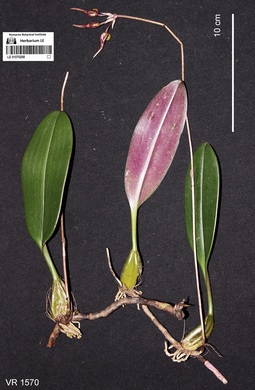
LE 01070208
Bulbophyllum longibrachiatum Z.H.Tsi det. Averyanov, Leonid Vladimirovich at 11.10.2019
Collectors: Averyanov, Leonid Vladimirovich; Khang Sinh Nguyen; Maisak, Tatiana Viktorovna Field collecting number: VR1570. Collection date: 11.10.2019. Administrative regions: VN - Tinh Ha Giang. Groups of specimens: L. V. Averyanov specimens; L. V. Averyanov photos; Orchids of Vietnam, Laos and CambodiaOriginal label text:FLORA OF VIETNAM
Coordinates (geographic position): 23° 5′ 44.38″ N, 105° 1′ 17.11″ E ±1000 mComment: Orchidaceae
Bulbophyllum longibrachiatum Z.H. Tsi
Ha Giang Prov., Quan Ba Distr., Can Ty Commune, Sin Suoi Ho Village, around point 23.09566ºN 105.02142ºE. Very steep mountain slopes composed of solid highly eroded karstic limestone at elevation 800–1000 m a.s.l. Remnants of primary evergreen broad-leaved and coniferous (with Calocedrus rupestris and Xanthocyparis vietnamensis) humid forest. Creeping lithophytic and epiphytic herb. Leaves purple-violet below. Common. 11 October 2019, L. Averyanov, Nguyen Sinh Khang, T. Maisak, VR 1570.
All photos © L. Averyanov & K.S. Nguyen
Record creation: 2020-01-04, Аверьянов Леонид Владимирович. Processing status: work_status_1Citation: Specimen LE 01070208 // Virtual herbarium of Komarov Botanical Institute RAS — http://re.herbariumle.ru/01070208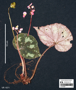
LE 01070207
Paratype of Begonia pseudodryadis C.Y.Wu var. bitepala Aver. det. Averyanov, Leonid Vladimirovich at 10.12.2019
Collectors: Averyanov, Leonid Vladimirovich; Khang Sinh Nguyen; Maisak, Tatiana Viktorovna Field collecting number: VR1571. Collection date: 11.10.2019. Administrative regions: VN - Tinh Ha Giang. Groups of specimens: L. V. Averyanov specimens; L. V. Averyanov photosOriginal label text:FLORA OF VIETNAM
Coordinates (geographic position): 23° 5′ 44.38″ N, 105° 1′ 17.11″ E ±1000 mComment: Begoniaceae
Begonia pseudodryadis C.Y. Wu var. bitepala Aver., var. nov.
Ha Giang Prov., Quan Ba Distr., Can Ty Commune, Sin Suoi Ho Village, around point 23.09566ºN 105.02142ºE. Very steep mountain slopes composed of solid highly eroded karstic limestone at elevation 800–1000 m a.s.l. Remnants of primary evergreen broad-leaved and coniferous (with Calocedrus rupestris and Xanthocyparis vietnamensis) humid forest. Rosulate lithophytic herb on vertical shady mossy cliff. Leaves dark olive-green with irregular whitish spots above, pale purple with light greenish spots below. Flowers light pink-purple, anther yellow. Locally common. 11 October 2019, L. Averyanov, Nguyen Sinh Khang, T. Maisak, VR 1571.
All photos © L. Averyanov & K.S. Nguyen
Record creation: 2020-01-04, Аверьянов Леонид ВладимировичCitation: Specimen LE 01070207 // Virtual herbarium of Komarov Botanical Institute RAS — http://re.herbariumle.ru/01070207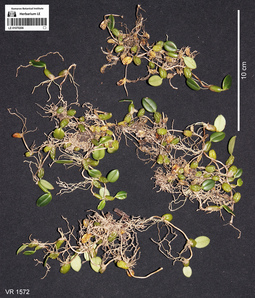
LE 01070206
Bulbophyllum sp. det. Averyanov, Leonid Vladimirovich at 11.10.2019
Collectors: Averyanov, Leonid Vladimirovich; Khang Sinh Nguyen; Maisak, Tatiana Viktorovna Field collecting number: VR1572. Collection date: 11.10.2019. Administrative regions: VN - Tinh Ha Giang. Groups of specimens: L. V. Averyanov specimens; L. V. Averyanov photos; Orchids of Vietnam, Laos and CambodiaOriginal label text:FLORA OF VIETNAM
Coordinates (geographic position): 23° 5′ 44.38″ N, 105° 1′ 17.11″ E ±1000 mComment: Orchidaceae
Bulbophyllum sp.
Ha Giang Prov., Quan Ba Distr., Can Ty Commune, Sin Suoi Ho Village, around point 23.09566ºN 105.02142ºE. Very steep mountain slopes composed of solid highly eroded karstic limestone at elevation 800–1000 m a.s.l. Remnants of primary evergreen broad-leaved and coniferous (with Calocedrus rupestris and Xanthocyparis vietnamensis) humid forest. Creeping epiphyte on old mossy tree. Occasional. 11 October 2019, L. Averyanov, Nguyen Sinh Khang, T. Maisak, VR 1572.
All photos © L. Averyanov & K.S. Nguyen
Record creation: 2020-01-04, Аверьянов Леонид Владимирович. Processing status: work_status_1Citation: Specimen LE 01070206 // Virtual herbarium of Komarov Botanical Institute RAS — http://re.herbariumle.ru/01070206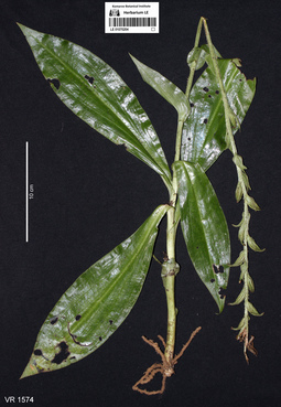
LE 01070204
Habenaria calcicola Aver. det. Averyanov, Leonid Vladimirovich at 11.10.2019
Collectors: Averyanov, Leonid Vladimirovich; Khang Sinh Nguyen; Maisak, Tatiana Viktorovna Field collecting number: VR1574. Collection date: 11.10.2019. Administrative regions: VN - Tinh Ha Giang. Groups of specimens: L. V. Averyanov specimens; L. V. Averyanov photos; Orchids of Vietnam, Laos and CambodiaOriginal label text:FLORA OF VIETNAM
Coordinates (geographic position): 23° 5′ 44.38″ N, 105° 1′ 17.11″ E ±1000 mComment: Orchidaceae
Habenaria calcicola Aver.?
Ha Giang Prov., Quan Ba Distr., Can Ty Commune, Sin Suoi Ho Village, around point 23.09566ºN 105.02142ºE. Very steep mountain slopes composed of solid highly eroded karstic limestone at elevation 800–1000 m a.s.l. Remnants of primary evergreen broad-leaved and coniferous (with Calocedrus rupestris and Xanthocyparis vietnamensis) humid forest. Terrestrial tuberiferous herb in shady place among rocks. Common.
11 October 2019, L. Averyanov, Nguyen Sinh Khang, T. Maisak, VR 1574.
All photos © L. Averyanov & K.S. Nguyen
Record creation: 2020-01-04, Аверьянов Леонид Владимирович. Processing status: work_status_1Citation: Specimen LE 01070204 // Virtual herbarium of Komarov Botanical Institute RAS — http://re.herbariumle.ru/01070204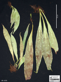
LE 01070203
Antrophyum callifolium Blume det. Averyanov, Leonid Vladimirovich at 10.12.2019
Collectors: Averyanov, Leonid Vladimirovich; Khang Sinh Nguyen; Maisak, Tatiana Viktorovna Field collecting number: VR1575. Collection date: 11.10.2019. Administrative regions: VN - Tinh Ha Giang. Groups of specimens: L. V. Averyanov specimens; L. V. Averyanov photosOriginal label text:FLORA OF VIETNAM
Coordinates (geographic position): 23° 5′ 44.38″ N, 105° 1′ 17.11″ E ±1000 mComment: Polypodiaceae s.l.
Antrophyum callifolium Blume
Ha Giang Prov., Quan Ba Distr., Can Ty Commune, Sin Suoi Ho Village, around point 23.09566ºN 105.02142ºE. Very steep mountain slopes composed of solid highly eroded karstic limestone at elevation 800–1000 m a.s.l. Remnants of primary evergreen broad-leaved and coniferous (with Calocedrus rupestris and Xanthocyparis vietnamensis) humid forest. Lithophytic fern on shady mossy cliff. Common. 11 October 2019, L. Averyanov, Nguyen Sinh Khang, T. Maisak, VR 1575.
All photos © L. Averyanov & K.S. Nguyen
Record creation: 2020-01-04, Аверьянов Леонид ВладимировичCitation: Specimen LE 01070203 // Virtual herbarium of Komarov Botanical Institute RAS — http://re.herbariumle.ru/01070203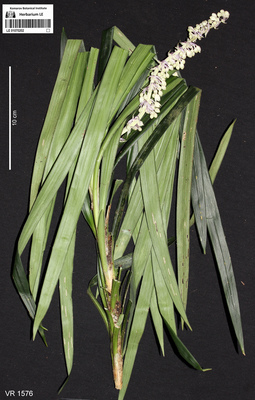
LE 01070202
Ophiopogon latifolius L.Rodr. det. Averyanov, Leonid Vladimirovich, Noriyuki Tanaka at 11.10.2019
Collectors: Averyanov, Leonid Vladimirovich; Khang Sinh Nguyen; Maisak, Tatiana Viktorovna Field collecting number: VR1576. Collection date: 11.10.2019. Administrative regions: VN - Tinh Ha Giang. Groups of specimens: L. V. Averyanov specimens; L. V. Averyanov photosOriginal label text:FLORA OF VIETNAM
Coordinates (geographic position): 23° 5′ 44.38″ N, 105° 1′ 17.11″ E ±1000 mComment: Convallariaceae
Ophiopogon latifolius L. Rodr.
Ha Giang Prov., Quan Ba Distr., Can Ty Commune, Sin Suoi Ho Village, around point 23.09566ºN 105.02142ºE. Very steep mountain slopes composed of solid highly eroded karstic limestone at elevation 800–1000 m a.s.l. Remnants of primary evergreen broad-leaved and coniferous (with Calocedrus rupestris and Xanthocyparis vietnamensis) humid forest. Terrestrial herb with stem 0.6-0.7 m tall in shady place among rocks. Flowers almost white. Common. 11 October 2019, L. Averyanov, Nguyen Sinh Khang, T. Maisak, VR 1576.
All photos © L. Averyanov & K.S. Nguyen
Record creation: 2020-01-04, Аверьянов Леонид ВладимировичCitation: Specimen LE 01070202 // Virtual herbarium of Komarov Botanical Institute RAS — http://re.herbariumle.ru/01070202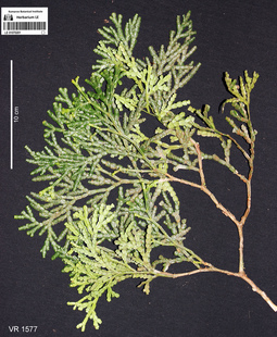
LE 01070201
Calocedrus rupestris Aver., T.H.Nguyên & P.K.Lôc det. Averyanov, Leonid Vladimirovich at 11.10.2019
Collectors: Averyanov, Leonid Vladimirovich; Khang Sinh Nguyen; Maisak, Tatiana Viktorovna Field collecting number: VR1577. Collection date: 11.10.2019. Administrative regions: VN - Tinh Ha Giang. Groups of specimens: L. V. Averyanov specimens; L. V. Averyanov photosOriginal label text:FLORA OF VIETNAM
Coordinates (geographic position): 23° 5′ 44.38″ N, 105° 1′ 17.11″ E ±1000 mComment: Cupressaceae
Calocedrus rupestris Aver. & T.H.Nguyên & P.K.Lôc
Ha Giang Prov., Quan Ba Distr., Can Ty Commune, Sin Suoi Ho Village, around point 23.09566ºN 105.02142ºE. Very steep mountain slopes composed of solid highly eroded karstic limestone at elevation 800–1000 m a.s.l. Remnants of primary evergreen broad-leaved and coniferous (with Calocedrus rupestris and Xanthocyparis vietnamensis) humid forest. Tree 7 m tall on mountain top. Common. 11 October 2019, L. Averyanov, Nguyen Sinh Khang, T. Maisak, VR 1577.
All photos © L. Averyanov & K.S. Nguyen
Record creation: 2020-01-04, Аверьянов Леонид ВладимировичCitation: Specimen LE 01070201 // Virtual herbarium of Komarov Botanical Institute RAS — http://re.herbariumle.ru/01070201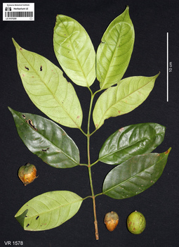
LE 01070200
Garcinia sp. det. Averyanov, Leonid Vladimirovich at 10.12.2019
Collectors: Averyanov, Leonid Vladimirovich; Khang Sinh Nguyen; Maisak, Tatiana Viktorovna Field collecting number: VR1578. Collection date: 11.10.2019. Administrative regions: VN - Tinh Ha Giang. Groups of specimens: L. V. Averyanov specimens; L. V. Averyanov photosOriginal label text:FLORA OF VIETNAM
Coordinates (geographic position): 23° 5′ 44.38″ N, 105° 1′ 17.11″ E ±1000 mComment: Clusiaceae
Garcinia sp.
Ha Giang Prov., Quan Ba Distr., Can Ty Commune, Sin Suoi Ho Village, around point 23.09566ºN 105.02142ºE. Very steep mountain slopes composed of solid highly eroded karstic limestone at elevation 800–1000 m a.s.l. Remnants of primary evergreen broad-leaved and coniferous (with Calocedrus rupestris and Xanthocyparis vietnamensis) humid forest. Tree 10-15 m. Fruits green. Very common. 11 October 2019, L. Averyanov, Nguyen Sinh Khang, T. Maisak, VR 1578.
All photos © L. Averyanov & K.S. Nguyen
Record creation: 2020-01-04, Аверьянов Леонид ВладимировичCitation: Specimen LE 01070200 // Virtual herbarium of Komarov Botanical Institute RAS — http://re.herbariumle.ru/01070200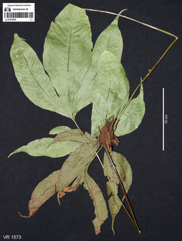
LE 01070205
Tectaria polymorpha (Hook.) Copel. det. Averyanov, Leonid Vladimirovich at 10.12.2019
Collectors: Averyanov, Leonid Vladimirovich; Khang Sinh Nguyen; Maisak, Tatiana Viktorovna Field collecting number: VR1573. Collection date: 11.10.2019. Administrative regions: VN - Tinh Ha Giang. Groups of specimens: L. V. Averyanov specimens; L. V. Averyanov photosOriginal label text:FLORA OF VIETNAM
Coordinates (geographic position): 23° 5′ 44.38″ N, 105° 1′ 17.11″ E ±1000 mComment: Polypodiaceae s.l. (Tectariaceae)
Tectaria polymorpha (Wall. ex Hook.) Copel.
Ha Giang Prov., Quan Ba Distr., Can Ty Commune, Sin Suoi Ho Village, around point 23.09566ºN 105.02142ºE. Very steep mountain slopes composed of solid highly eroded karstic limestone at elevation 800–1000 m a.s.l. Remnants of primary evergreen broad-leaved and coniferous (with Calocedrus rupestris and Xanthocyparis vietnamensis) humid forest. Terrestrial fern in shady rocky place. Common. 11 October 2019, L. Averyanov, Nguyen Sinh Khang, T. Maisak, VR 1573.
All photos © L. Averyanov & K.S. Nguyen
Record creation: 2020-01-04, Аверьянов Леонид ВладимировичCitation: Specimen LE 01070205 // Virtual herbarium of Komarov Botanical Institute RAS — http://re.herbariumle.ru/01070205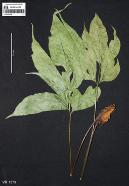
LE 01070199
Tectaria polymorpha (Hook.) Copel. det. Averyanov, Leonid Vladimirovich at 10.12.2019
Collectors: Averyanov, Leonid Vladimirovich; Khang Sinh Nguyen; Maisak, Tatiana Viktorovna Field collecting number: VR1573. Collection date: 11.10.2019. Administrative regions: VN - Tinh Ha Giang. Groups of specimens: L. V. Averyanov specimens; L. V. Averyanov photosOriginal label text:FLORA OF VIETNAM
Coordinates (geographic position): 23° 5′ 44.38″ N, 105° 1′ 17.11″ E ±1000 mComment: Polypodiaceae s.l. (Tectariaceae)
Tectaria polymorpha (Wall. ex Hook.) Copel.
Ha Giang Prov., Quan Ba Distr., Can Ty Commune, Sin Suoi Ho Village, around point 23.09566ºN 105.02142ºE. Very steep mountain slopes composed of solid highly eroded karstic limestone at elevation 800–1000 m a.s.l. Remnants of primary evergreen broad-leaved and coniferous (with Calocedrus rupestris and Xanthocyparis vietnamensis) humid forest. Terrestrial fern in shady rocky place. Common. 11 October 2019, L. Averyanov, Nguyen Sinh Khang, T. Maisak, VR 1573.
All photos © L. Averyanov & K.S. Nguyen
Record creation: 2020-01-04, Аверьянов Леонид ВладимировичCitation: Specimen LE 01070199 // Virtual herbarium of Komarov Botanical Institute RAS — http://re.herbariumle.ru/01070199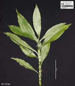
LE 01070198
Rohdea wattii (C.B.Clarke) Yamashita & M.N.Tamura det. Averyanov, Leonid Vladimirovich at 11.10.2019
Additional identifications: Tupistra wattii Hook.f. det. Averyanov, Leonid Vladimirovich at 11.10.2019 Collectors: Averyanov, Leonid Vladimirovich; Khang Sinh Nguyen; Maisak, Tatiana Viktorovna Field collecting number: VR1579. Collection date: 11.10.2019. Administrative regions: VN - Tinh Ha Giang. Groups of specimens: L. V. Averyanov specimens; L. V. Averyanov photosOriginal label text:FLORA OF VIETNAM
Coordinates (geographic position): 23° 5′ 44.38″ N, 105° 1′ 17.11″ E ±1000 mComment: Convallariaceae
Rohdea wattii (C.B.Clarke) Yamashita & M.N.Tamura (= Tupistra wattii (C.B. Clarke) Hook.f.)
Ha Giang Prov., Quan Ba Distr., Can Ty Commune, Sin Suoi Ho Village, around point 23.09566ºN 105.02142ºE. Very steep mountain slopes composed of solid highly eroded karstic limestone at elevation 800–1000 m a.s.l. Remnants of primary evergreen broad-leaved and coniferous (with Calocedrus rupestris and Xanthocyparis vietnamensis) humid forest. Terrestrial herb in shady place among rocks. Flowers and flower bracts green. Very common. 11 October 2019, L. Averyanov, Nguyen Sinh Khang, T. Maisak, VR 1579.
All photos © L. Averyanov & K.S. Nguyen
Record creation: 2020-01-04, Аверьянов Леонид ВладимировичCitation: Specimen LE 01070198 // Virtual herbarium of Komarov Botanical Institute RAS — http://re.herbariumle.ru/01070198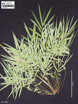
LE 01070197
Neomicrocalamus prainii (Gamble) Keng f. det. Khang Sinh Nguyen at 11.10.2019
Collectors: Averyanov, Leonid Vladimirovich; Khang Sinh Nguyen; Maisak, Tatiana Viktorovna Field collecting number: VR1580. Collection date: 11.10.2019. Administrative regions: VN - Tinh Ha Giang. Groups of specimens: L. V. Averyanov specimens; L. V. Averyanov photosOriginal label text:FLORA OF VIETNAM
Coordinates (geographic position): 23° 5′ 44.38″ N, 105° 1′ 17.11″ E ±1000 mComment: Poaceae (Bambusoideae)
Neomicrocalamus prainii (Gamble) Keng f.
Ha Giang Prov., Quan Ba Distr., Can Ty Commune, Sin Suoi Ho Village, around point 23.09566ºN 105.02142ºE. Very steep mountain slopes composed of solid highly eroded karstic limestone at elevation 800–1000 m a.s.l. Remnants of primary evergreen broad-leaved and coniferous (with Calocedrus rupestris and Xanthocyparis vietnamensis) humid forest. Woody grass with pendulous stems to 10 m long on very steep rocky slopes and cliffs. Locally very common. 11 October 2019, L. Averyanov, Nguyen Sinh Khang, T. Maisak, VR 1580.
All photos © L. Averyanov & K.S. Nguyen
Record creation: 2020-01-04, Аверьянов Леонид ВладимировичCitation: Specimen LE 01070197 // Virtual herbarium of Komarov Botanical Institute RAS — http://re.herbariumle.ru/01070197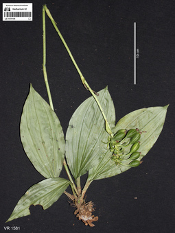
LE 01070196
Calanthe herbacea Lindl. det. Averyanov, Leonid Vladimirovich at 11.10.2019
Collectors: Averyanov, Leonid Vladimirovich; Khang Sinh Nguyen; Maisak, Tatiana Viktorovna Field collecting number: VR1581. Collection date: 11.10.2019. Administrative regions: VN - Tinh Ha Giang. Groups of specimens: L. V. Averyanov specimens; L. V. Averyanov photos; Orchids of Vietnam, Laos and CambodiaOriginal label text:FLORA OF VIETNAM
Coordinates (geographic position): 23° 5′ 44.38″ N, 105° 1′ 17.11″ E ±1000 mComment: Orchidaceae
Calanthe herbacea Lindl.
Ha Giang Prov., Quan Ba Distr., Can Ty Commune, Sin Suoi Ho Village, around point 23.09566ºN 105.02142ºE. Very steep mountain slopes composed of solid highly eroded karstic limestone at elevation 800–1000 m a.s.l. Remnants of primary evergreen broad-leaved and coniferous (with Calocedrus rupestris and Xanthocyparis vietnamensis) humid forest. Terrestrial herb in shady rocky place. Not common. 11 October 2019, L. Averyanov, Nguyen Sinh Khang, T. Maisak, VR 1581.
All photos © L. Averyanov & K.S. Nguyen
Record creation: 2020-01-04, Аверьянов Леонид Владимирович. Processing status: work_status_1Citation: Specimen LE 01070196 // Virtual herbarium of Komarov Botanical Institute RAS — http://re.herbariumle.ru/01070196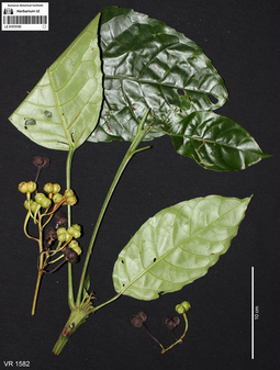
LE 01070195
Trigonostemon thyrsoideus Stapf det. Averyanov, Leonid Vladimirovich at 10.12.2019
Collectors: Averyanov, Leonid Vladimirovich; Khang Sinh Nguyen; Maisak, Tatiana Viktorovna Field collecting number: VR1582. Collection date: 11.10.2019. Administrative regions: VN - Tinh Ha Giang. Groups of specimens: L. V. Averyanov specimens; L. V. Averyanov photosOriginal label text:FLORA OF VIETNAM
Coordinates (geographic position): 23° 5′ 44.38″ N, 105° 1′ 17.11″ E ±1000 mComment: Euphorbiaceae
Trigonostemon thyrsoideus Stapf
Ha Giang Prov., Quan Ba Distr., Can Ty Commune, Sin Suoi Ho Village, around point 23.09566ºN 105.02142ºE. Very steep mountain slopes composed of solid highly eroded karstic limestone at elevation 800–1000 m a.s.l. Remnants of primary evergreen broad-leaved and coniferous (with Calocedrus rupestris and Xanthocyparis vietnamensis) humid forest. Treelet of shrub 3-5 m tall and 3-4 cm in diameter. Fruits light green. Common. 11 October 2019, L. Averyanov, Nguyen Sinh Khang, T. Maisak, VR 1582.
All photos © L. Averyanov & K.S. Nguyen
Record creation: 2020-01-04, Аверьянов Леонид ВладимировичCitation: Specimen LE 01070195 // Virtual herbarium of Komarov Botanical Institute RAS — http://re.herbariumle.ru/01070195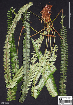
LE 01070194
Polystichum deltatum Li Bing Zhang, M.Q.Han & Yan Liu det. Averyanov, Leonid Vladimirovich at 10.12.2019
Collectors: Averyanov, Leonid Vladimirovich; Khang Sinh Nguyen; Maisak, Tatiana Viktorovna Field collecting number: VR1583. Collection date: 11.10.2019. Administrative regions: VN - Tinh Ha Giang. Groups of specimens: L. V. Averyanov specimens; L. V. Averyanov photosOriginal label text:FLORA OF VIETNAM
Coordinates (geographic position): 23° 5′ 44.38″ N, 105° 1′ 17.11″ E ±1000 mComment: Polypodiaceae s.l.
Polystichum deltatum Li Bing Zhang, M.Q. Han & Yan Liu
Ha Giang Prov., Quan Ba Distr., Can Ty Commune, Sin Suoi Ho Village, around point 23.09566ºN 105.02142ºE. Very steep mountain slopes composed of solid highly eroded karstic limestone at elevation 800–1000 m a.s.l. Remnants of primary evergreen broad-leaved and coniferous (with Calocedrus rupestris and Xanthocyparis vietnamensis) humid forest. Lithophytic fern on steep rocky slope. Very common. 11 October 2019, L. Averyanov, Nguyen Sinh Khang, T. Maisak, VR 1583.
All photos © L. Averyanov & K.S. Nguyen
Record creation: 2020-01-04, Аверьянов Леонид ВладимировичCitation: Specimen LE 01070194 // Virtual herbarium of Komarov Botanical Institute RAS — http://re.herbariumle.ru/01070194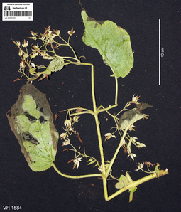
LE 01070193
Ornithoboea wildeana Craib det. Averyanov, Leonid Vladimirovich at 10.12.2019
Collectors: Averyanov, Leonid Vladimirovich; Khang Sinh Nguyen; Maisak, Tatiana Viktorovna Field collecting number: VR1584. Collection date: 11.10.2019. Administrative regions: VN - Tinh Ha Giang. Groups of specimens: L. V. Averyanov specimens; L. V. Averyanov photosOriginal label text:FLORA OF VIETNAM
Coordinates (geographic position): 23° 5′ 44.38″ N, 105° 1′ 17.11″ E ±1000 mComment: Gesneriaceae
Ornithoboea wildeana Craib
Ha Giang Prov., Quan Ba Distr., Can Ty Commune, Sin Suoi Ho Village, around point 23.09566ºN 105.02142ºE. Very steep mountain slopes composed of solid highly eroded karstic limestone at elevation 800–1000 m a.s.l. Remnants of primary evergreen broad-leaved and coniferous (with Calocedrus rupestris and Xanthocyparis vietnamensis) humid forest. Lithophytic herb to 1 m tall on steep rocky slope. Very common. 11 October 2019, L. Averyanov, Nguyen Sinh Khang, T. Maisak, VR 1584.
All photos © L. Averyanov & K.S. Nguyen
Record creation: 2020-01-04, Аверьянов Леонид ВладимировичCitation: Specimen LE 01070193 // Virtual herbarium of Komarov Botanical Institute RAS — http://re.herbariumle.ru/01070193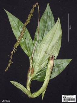
LE 01070192
Malaxis ophrydis (J.Koenig) Ormerod det. Averyanov, Leonid Vladimirovich at 11.10.2019
Collectors: Averyanov, Leonid Vladimirovich; Khang Sinh Nguyen; Maisak, Tatiana Viktorovna Field collecting number: VR1585. Collection date: 11.10.2019. Administrative regions: VN - Tinh Ha Giang. Groups of specimens: L. V. Averyanov specimens; L. V. Averyanov photos; Orchids of Vietnam, Laos and CambodiaOriginal label text:FLORA OF VIETNAM
Coordinates (geographic position): 23° 5′ 44.38″ N, 105° 1′ 17.11″ E ±1000 mComment: Orchidaceae
Malaxis ophrydis (J. Koenig) Ormerod
Ha Giang Prov., Quan Ba Distr., Can Ty Commune, Sin Suoi Ho Village, around point 23.09566ºN 105.02142ºE. Very steep mountain slopes composed of solid highly eroded karstic limestone at elevation 800–1000 m a.s.l. Remnants of primary evergreen broad-leaved and coniferous (with Calocedrus rupestris and Xanthocyparis vietnamensis) humid forest. Terrestrial herb in shady place among rocks. Common. 11 October 2019, L. Averyanov, Nguyen Sinh Khang, T. Maisak, VR 1585.
All photos © L. Averyanov & K.S. Nguyen
Record creation: 2020-01-04, Аверьянов Леонид Владимирович. Processing status: work_status_1Citation: Specimen LE 01070192 // Virtual herbarium of Komarov Botanical Institute RAS — http://re.herbariumle.ru/01070192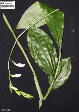
LE 01070191
Phaius mishmensis (Lindl. & Paxton) Rchb.f. det. Averyanov, Leonid Vladimirovich at 11.10.2019
Collectors: Averyanov, Leonid Vladimirovich; Khang Sinh Nguyen; Maisak, Tatiana Viktorovna Field collecting number: VR1586. Collection date: 11.10.2019. Administrative regions: VN - Tinh Ha Giang. Groups of specimens: L. V. Averyanov specimens; L. V. Averyanov photos; Orchids of Vietnam, Laos and CambodiaOriginal label text:FLORA OF VIETNAM
Coordinates (geographic position): 23° 5′ 44.38″ N, 105° 1′ 17.11″ E ±1000 mComment: Orchidaceae
Phaius mishmensis Rchb.f.,
Ha Giang Prov., Quan Ba Distr., Can Ty Commune, Sin Suoi Ho Village, around point 23.09566ºN 105.02142ºE. Very steep mountain slopes composed of solid highly eroded karstic limestone at elevation 800–1000 m a.s.l. Remnants of primary evergreen broad-leaved and coniferous (with Calocedrus rupestris and Xanthocyparis vietnamensis) humid forest. Terrestrial herb in shady place among rocks. Flowers pinkish. Not common. 11 October 2019, L. Averyanov, Nguyen Sinh Khang, T. Maisak, VR 1586.
All photos © L. Averyanov & K.S. Nguyen
Record creation: 2020-01-04, Аверьянов Леонид Владимирович. Processing status: work_status_1Citation: Specimen LE 01070191 // Virtual herbarium of Komarov Botanical Institute RAS — http://re.herbariumle.ru/01070191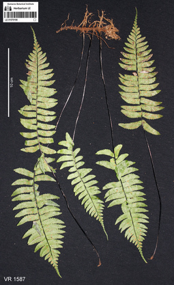
LE 01070190
Asplenium unilaterale Lam. det. Averyanov, Leonid Vladimirovich at 10.12.2019
Additional identifications: Hymenasplenium unilaterale (Lam.) Hayata det. Averyanov, Leonid Vladimirovich at 19.02.2020 Collectors: Averyanov, Leonid Vladimirovich; Khang Sinh Nguyen; Maisak, Tatiana Viktorovna Field collecting number: VR1587. Collection date: 11.10.2019. Administrative regions: VN - Tinh Ha Giang. Groups of specimens: L. V. Averyanov specimens; L. V. Averyanov photosOriginal label text:FLORA OF VIETNAM
Coordinates (geographic position): 23° 5′ 44.38″ N, 105° 1′ 17.11″ E ±1000 mComment: Polypodiaceae s.l.
Asplenium unilaterale Lam.
Ha Giang Prov., Quan Ba Distr., Can Ty Commune, Sin Suoi Ho Village, around point 23.09566ºN 105.02142ºE. Very steep mountain slopes composed of solid highly eroded karstic limestone at elevation 800–1000 m a.s.l. Remnants of primary evergreen broad-leaved and coniferous (with Calocedrus rupestris and Xanthocyparis vietnamensis) humid forest. Terrestrial and occasionally lithophytic fern on shady very steep rocky slope. Common. 11 October 2019, L. Averyanov, Nguyen Sinh Khang, T. Maisak, VR 1587.
All photos © L. Averyanov & K.S. Nguyen
Record creation: 2020-01-04, Аверьянов Леонид ВладимировичCitation: Specimen LE 01070190 // Virtual herbarium of Komarov Botanical Institute RAS — http://re.herbariumle.ru/01070190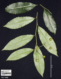
LE 01070189
Ardisia sp. det. Averyanov, Leonid Vladimirovich at 10.12.2019
Collectors: Averyanov, Leonid Vladimirovich; Khang Sinh Nguyen; Maisak, Tatiana Viktorovna Field collecting number: VR1588. Collection date: 11.10.2019. Administrative regions: VN - Tinh Ha Giang. Groups of specimens: L. V. Averyanov specimens; L. V. Averyanov photosOriginal label text:FLORA OF VIETNAM
Coordinates (geographic position): 23° 5′ 44.38″ N, 105° 1′ 17.11″ E ±1000 mComment: Myrsinaceae
Ardisia sp.
Ha Giang Prov., Quan Ba Distr., Can Ty Commune, Sin Suoi Ho Village, around point 23.09566ºN 105.02142ºE. Very steep mountain slopes composed of solid highly eroded karstic limestone at elevation 800–1000 m a.s.l. Remnants of primary evergreen broad-leaved and coniferous (with Calocedrus rupestris and Xanthocyparis vietnamensis) humid forest. Treelet 2-3 m tall on shady very steep rocky slope. Fruits glossy green speckled with small whitish spots. Common. 11 October 2019, L. Averyanov, Nguyen Sinh Khang, T. Maisak, VR 1588.
All photos © L. Averyanov & K.S. Nguyen
Record creation: 2020-01-04, Аверьянов Леонид ВладимировичCitation: Specimen LE 01070189 // Virtual herbarium of Komarov Botanical Institute RAS — http://re.herbariumle.ru/01070189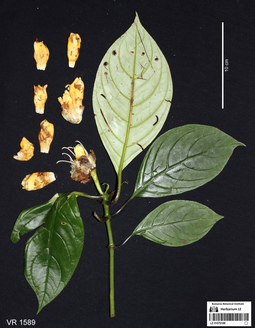
LE 01070188
Hemiboea malipoensis Y.H.Tan det. Averyanov, Leonid Vladimirovich, Khang Sinh Nguyen at 10.12.2019
Collectors: Averyanov, Leonid Vladimirovich; Khang Sinh Nguyen; Maisak, Tatiana Viktorovna Field collecting number: VR1589. Collection date: 11.10.2019. Administrative regions: VN - Tinh Ha Giang. Groups of specimens: L. V. Averyanov specimens; L. V. Averyanov photosOriginal label text:FLORA OF VIETNAM
Coordinates (geographic position): 23° 5′ 44.38″ N, 105° 1′ 17.11″ E ±1000 mComment: Gesneriaceae
Hemiboea malipoensis Y.H. Tan
Ha Giang Prov., Quan Ba Distr., Can Ty Commune, Sin Suoi Ho Village, around point 23.09566ºN 105.02142ºE. Very steep mountain slopes composed of solid highly eroded karstic limestone at elevation 800–1000 m a.s.l. Remnants of primary evergreen broad-leaved and coniferous (with Calocedrus rupestris and Xanthocyparis vietnamensis) humid forest. Terrestrial herb to 1.5 m tall on shady very steep rocky slope. Flowers yellow. Common. 11 October 2019, L. Averyanov, Nguyen Sinh Khang, T. Maisak, VR 1589.
All photos © L. Averyanov & K.S. Nguyen
Record creation: 2020-01-04, Аверьянов Леонид ВладимировичCitation: Specimen LE 01070188 // Virtual herbarium of Komarov Botanical Institute RAS — http://re.herbariumle.ru/01070188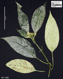
LE 01070186
Ophiorrhiza amplifolia Drake det. Averyanov, Leonid Vladimirovich at 08.12.2020
Additional identifications: Ophiorrhiza sp. det. Averyanov, Leonid Vladimirovich at 10.12.2019 Collectors: Averyanov, Leonid Vladimirovich; Khang Sinh Nguyen; Maisak, Tatiana Viktorovna Field collecting number: VR1590. Collection date: 11.10.2019. Administrative regions: VN - Tinh Ha Giang. Groups of specimens: L. V. Averyanov specimens; L. V. Averyanov photosOriginal label text:FLORA OF VIETNAM
Coordinates (geographic position): 23° 5′ 44.38″ N, 105° 1′ 17.11″ E ±1000 mComment: Rubiaceae
Ophiorrhiza sp.
Ha Giang Prov., Quan Ba Distr., Can Ty Commune, Sin Suoi Ho Village, around point 23.09566ºN 105.02142ºE. Very steep mountain slopes composed of solid highly eroded karstic limestone at elevation 800–1000 m a.s.l. Remnants of primary evergreen broad-leaved and coniferous (with Calocedrus rupestris and Xanthocyparis vietnamensis) humid forest. Terrestrial herb to 1.5 m tall on shady very steep rocky slope. Flowers white with greenish apex. Very common. 11 October 2019, L. Averyanov, Nguyen Sinh Khang, T. Maisak, VR 1590.
All photos © L. Averyanov & K.S. Nguyen
Record creation: 2020-01-04, Аверьянов Леонид ВладимировичCitation: Specimen LE 01070186 // Virtual herbarium of Komarov Botanical Institute RAS — http://re.herbariumle.ru/01070186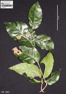
LE 01070187
Castanopsis sp. det. Averyanov, Leonid Vladimirovich at 10.12.2019
Collectors: Averyanov, Leonid Vladimirovich; Khang Sinh Nguyen; Maisak, Tatiana Viktorovna Field collecting number: VR1591. Collection date: 11.10.2019. Administrative regions: VN - Tinh Ha Giang. Groups of specimens: L. V. Averyanov specimens; L. V. Averyanov photosOriginal label text:FLORA OF VIETNAM
Coordinates (geographic position): 23° 5′ 44.38″ N, 105° 1′ 17.11″ E ±1000 mComment: Fagaceae
Castanopsis sp.?
Ha Giang Prov., Quan Ba Distr., Can Ty Commune, Sin Suoi Ho Village, around point 23.09566ºN 105.02142ºE. Very steep mountain slopes composed of solid highly eroded karstic limestone at elevation 800–1000 m a.s.l. Remnants of primary evergreen broad-leaved and coniferous (with Calocedrus rupestris and Xanthocyparis vietnamensis) humid forest. Tree to 12-15 m tall, bars brown. Very common. 11 October 2019, L. Averyanov, Nguyen Sinh Khang, T. Maisak, VR 1591.
All photos © L. Averyanov & K.S. Nguyen
Record creation: 2020-01-04, Аверьянов Леонид ВладимировичCitation: Specimen LE 01070187 // Virtual herbarium of Komarov Botanical Institute RAS — http://re.herbariumle.ru/01070187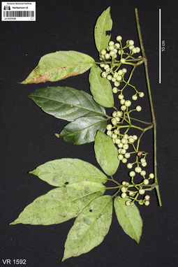
LE 01070185
Cayratia corniculata Gagnep. det. Averyanov, Leonid Vladimirovich at 10.12.2019
Collectors: Averyanov, Leonid Vladimirovich; Khang Sinh Nguyen; Maisak, Tatiana Viktorovna Field collecting number: VR1592. Collection date: 11.10.2019. Administrative regions: VN - Tinh Ha Giang. Groups of specimens: L. V. Averyanov specimens; L. V. Averyanov photosOriginal label text:FLORA OF VIETNAM
Coordinates (geographic position): 23° 5′ 44.38″ N, 105° 1′ 17.11″ E ±1000 mComment: Vitaceae
Cayratia corniculata Gagnep.
Ha Giang Prov., Quan Ba Distr., Can Ty Commune, Sin Suoi Ho Village, around point 23.09566ºN 105.02142ºE. Very steep mountain slopes composed of solid highly eroded karstic limestone at elevation 800–1000 m a.s.l. Remnants of primary evergreen broad-leaved and coniferous (with Calocedrus rupestris and Xanthocyparis vietnamensis) humid forest. Herbaceous or semiwoody vine to 4 m long in open rocky place. Fruits white. Common. 11 October 2019, L. Averyanov, Nguyen Sinh Khang, T. Maisak, VR 1592.
All photos © L. Averyanov & K.S. Nguyen
Record creation: 2020-01-04, Аверьянов Леонид ВладимировичCitation: Specimen LE 01070185 // Virtual herbarium of Komarov Botanical Institute RAS — http://re.herbariumle.ru/01070185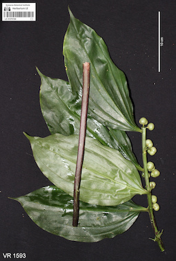
LE 01070184
Disporopsis longifolia Craib det. Averyanov, Leonid Vladimirovich, Noriyuki Tanaka at 10.12.2019
Collectors: Averyanov, Leonid Vladimirovich; Khang Sinh Nguyen; Maisak, Tatiana Viktorovna Field collecting number: VR1593. Collection date: 13.10.2019. Administrative regions: VN - Tinh Ha Giang. Groups of specimens: L. V. Averyanov specimens; L. V. Averyanov photosOriginal label text:FLORA OF VIETNAM
Comment: Convallariaceae
Disporopsis longifolia Craib
Ha Giang Prov., Quan Ba Distr., Quan Ba Village street market. Wild collected terrestrial herb to 2 m tall sold as a medicinal plant. Rhizome to 8 cm in diam, fruits glossy green. 13 October 2019, L. Averyanov, Nguyen Sinh Khang, T. Maisak, VR 1593.
All photos © L. Averyanov & K.S. Nguyen
Record creation: 2020-01-04, Аверьянов Леонид ВладимировичCitation: Specimen LE 01070184 // Virtual herbarium of Komarov Botanical Institute RAS — http://re.herbariumle.ru/01070184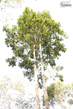
LE 01070158
Canarium album Blanco det. Averyanov, Leonid Vladimirovich at 10.12.2019
Collectors: Averyanov, Leonid Vladimirovich; Khang Sinh Nguyen; Maisak, Tatiana Viktorovna Field collecting number: VR1598. Collection date: 10.10.2019. Administrative regions: VN - Tinh Ha Giang. Groups of specimens: L. V. Averyanov specimens; L. V. Averyanov photosOriginal label text:FLORA OF VIETNAM
Coordinates (geographic position): 22° 58′ 11.57″ N, 105° 5′ 11.26″ E ±1000 mComment: Burseraceae
Canarium album Blanco?
Ha Giang Prov., Quan Ba Distr., Thai An Commune, Seo Lung Two Village, around point 22.96988ºN 105.08646ºE. Very steep mountain slopes composed of stratified shale and clayey subsoil at elevation 800–1000 m a.s.l. Primary and secondary evergreen broad-leaved humid forest. Tree to 30 m tall on steep slope. Not rare. 10 October 2019, L. Averyanov, Nguyen Sinh Khang, T. Maisak, VR 1598 (photo only).
All photos © L. Averyanov & K.S. Nguyen
Record creation: 2020-01-04, Аверьянов Леонид ВладимировичCitation: Specimen LE 01070158 // Virtual herbarium of Komarov Botanical Institute RAS — http://re.herbariumle.ru/01070158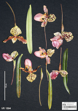
LE 01070183
Paphiopedilum henryanum Braem det. Averyanov, Leonid Vladimirovich at 13.10.2019
Collectors: Averyanov, Leonid Vladimirovich; Khang Sinh Nguyen; Maisak, Tatiana Viktorovna Field collecting number: VR1594. Collection date: 13.10.2019. Administrative regions: VN - Tinh Ha Giang. Groups of specimens: L. V. Averyanov specimens; L. V. Averyanov photos; Orchids of Vietnam, Laos and CambodiaOriginal label text:FLORA OF VIETNAM
Comment: Orchidaceae
Paphiopedilum henryanum Braem
Ha Giang Prov., Quan Ba Distr., Quan Ba Village street market. Wild collected lithophytic rosulate sold as an ornamental plant. Median tepal yellowish with maroon spots, lip punk-purple. Almost extinct in the nature in the area. 13 October 2019, L. Averyanov, Nguyen Sinh Khang, T. Maisak, VR 1594.
All photos © L. Averyanov
Record creation: 2020-01-04, Аверьянов Леонид Владимирович. Processing status: work_status_1Citation: Specimen LE 01070183 // Virtual herbarium of Komarov Botanical Institute RAS — http://re.herbariumle.ru/01070183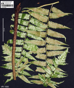
LE 01070182
Diplazium opacum (Don) Christ det. Averyanov, Leonid Vladimirovich at 10.12.2019
Additional identifications: Cornopteris opaca D.Don det. Averyanov, Leonid Vladimirovich at 19.02.2020 Collectors: Averyanov, Leonid Vladimirovich; Khang Sinh Nguyen; Maisak, Tatiana Viktorovna Field collecting number: VR1500. Collection date: 10.10.2019. Administrative regions: VN - Tinh Ha Giang. Groups of specimens: L. V. Averyanov specimens; L. V. Averyanov photosOriginal label text:FLORA OF VIETNAM
Coordinates (geographic position): 22° 58′ 11.57″ N, 105° 5′ 11.26″ E ±1000 mComment: Polypodiaceae s.l. (Athyriaceae)
Diplazium opacum (Don) Christ
Ha Giang Prov., Quan Ba Distr., Thai An Commune, Seo Lung Two Village, around point 22.96988ºN 105.08646ºE. Very steep mountain slopes composed of stratified shale and clayey subsoil at elevation 800–1000 m a.s.l. Primary and secondary evergreen broad-leaved humid forest. Terrestrial fern on very steep wet shady slope. Fronds to 2 m long. Very common. 10 October 2019, L. Averyanov, Nguyen Sinh Khang, T. Maisak, VR 1500.
All photos © L. Averyanov & K.S. Nguyen
Record creation: 2020-01-03, Аверьянов Леонид ВладимировичCitation: Specimen LE 01070182 // Virtual herbarium of Komarov Botanical Institute RAS — http://re.herbariumle.ru/01070182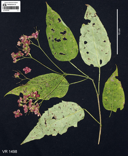
LE 01070181
Clerodendrum kwangtungense Hand.-Mazz. det. Chen Yaping at 08.12.2019
Collectors: Averyanov, Leonid Vladimirovich; Khang Sinh Nguyen; Maisak, Tatiana Viktorovna Field collecting number: VR1498. Collection date: 10.10.2019. Administrative regions: VN - Tinh Ha Giang. Groups of specimens: L. V. Averyanov specimens; L. V. Averyanov photosOriginal label text:FLORA OF VIETNAM
Coordinates (geographic position): 22° 58′ 11.57″ N, 105° 5′ 11.26″ E ±1000 mComment: Verbenaceae
Clerodendrum kwangtungense Hand.-Mazz.
Ha Giang Prov., Quan Ba Distr., Thai An Commune, Seo Lung Two Village, around point 22.96988ºN 105.08646ºE. Very steep mountain slopes composed of stratified shale and clayey subsoil at elevation 800–1000 m a.s.l. Primary and secondary evergreen broad-leaved humid forest. Treelet or shrub 3-4 m tall. Calyx pink, fruits black. Occasional. 10 October 2019, L. Averyanov, Nguyen Sinh Khang, T. Maisak, VR 1498. Det.: Chen Yaping 08.12.2019
All photos © L. Averyanov & K.S. Nguyen
Record creation: 2020-01-02, Аверьянов Леонид ВладимировичCitation: Specimen LE 01070181 // Virtual herbarium of Komarov Botanical Institute RAS — http://re.herbariumle.ru/01070181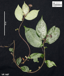
LE 01061033
Elatostema radicans Wedd. det. Fu Longfei at 09.12.2019
Collectors: Averyanov, Leonid Vladimirovich; Khang Sinh Nguyen; Maisak, Tatiana Viktorovna Field collecting number: VR1497. Collection date: 09.10.2019. Administrative regions: VN - Tinh Ha Giang. Groups of specimens: L. V. Averyanov specimens; L. V. Averyanov photosOriginal label text:FLORA OF VIETNAM
Coordinates (geographic position): 22° 58′ 11.57″ N, 105° 5′ 11.26″ E ±1000 mComment: Urticaceae
Elatostema radicans Wedd.
Ha Giang Prov., Quan Ba Distr., Thai An Commune, Seo Lung Two Village, around point 22.96988ºN 105.08646ºE. Very steep mountain slopes composed of stratified shale and clayey subsoil at elevation 800–1000 m a.s.l. Primary and secondary evergreen broad-leaved humid forest. Terrestrial herb on very steep wet shady slope. Flowers dirty violet. Occasional. 10 October 2019, L. Averyanov, Nguyen Sinh Khang, T. Maisak, VR 1497. Det.: Fu Longfei 09.12.2019
All photos © L. Averyanov & K.S. Nguyen
Record creation: 2020-01-02, Аверьянов Леонид ВладимировичCitation: Specimen LE 01061033 // Virtual herbarium of Komarov Botanical Institute RAS — http://re.herbariumle.ru/01061033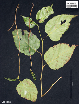
LE 01061034
Betula alnoides Buch.-Ham. det. Averyanov, Leonid Vladimirovich at 09.10.2019
Collectors: Averyanov, Leonid Vladimirovich; Khang Sinh Nguyen; Maisak, Tatiana Viktorovna Field collecting number: VR1496. Collection date: 09.10.2019. Administrative regions: VN - Tinh Ha Giang. Groups of specimens: L. V. Averyanov specimens; L. V. Averyanov photosOriginal label text:FLORA OF VIETNAM
Coordinates (geographic position): 22° 58′ 11.57″ N, 105° 5′ 11.26″ E ±1000 mComment: Betulaceae
Betula alnoides Buch.-Ham.
Ha Giang Prov., Quan Ba Distr., Thai An Commune, Seo Lung Two Village, around point 22.96988ºN 105.08646ºE. Very steep mountain slopes composed of stratified shale and clayey subsoil at elevation 800–1000 m a.s.l. Primary and secondary evergreen broad-leaved humid forest. Semideciduous tree to 30 m tall. Very common. Co-dominant (or occasional mono-dominant) of the forest. 10 October 2019, L. Averyanov, Nguyen Sinh Khang, T. Maisak, VR 1496.
All photos © L. Averyanov & K.S. Nguyen
Record creation: 2020-01-02, Аверьянов Леонид ВладимировичCitation: Specimen LE 01061034 // Virtual herbarium of Komarov Botanical Institute RAS — http://re.herbariumle.ru/01061034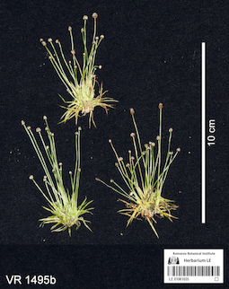
LE 01061035
Eriocaulon nigrum Lecomte ⟮prelim. ID⟯ det. Averyanov, Leonid Vladimirovich at 10.12.2019
Collectors: Averyanov, Leonid Vladimirovich; Khang Sinh Nguyen; Maisak, Tatiana Viktorovna Field collecting number: VR1495b. Collection date: 09.10.2019. Administrative regions: VN - Tinh Ha Giang. Groups of specimens: L. V. Averyanov specimens; L. V. Averyanov photosOriginal label text:FLORA OF VIETNAM
Coordinates (geographic position): 23° 2′ 6.47″ N, 104° 52′ 12.58″ E ±1000 mComment: Eriocaulaceae
Eriocaulon nigrum Lecomte?
Ha Giang Prov., Quan Ba Distr., Ta Van Commune, Can Ho Village, around point 23.03513ºN 104.87016ºE, steep rocky mountain slopes composed of eroded limestone at elevation 1100–1250 m a.s.l. Secondary evergreen broad-leaved humid forest. Terrestrial herb in open grassy place at the base of mountain. Inflorescences white. Common. 9 October 2019, L. Averyanov, Nguyen Sinh Khang, T. Maisak, VR 1495b.
All photos © L. Averyanov & K.S. Nguyen
Record creation: 2020-01-02, Аверьянов Леонид ВладимировичCitation: Specimen LE 01061035 // Virtual herbarium of Komarov Botanical Institute RAS — http://re.herbariumle.ru/01061035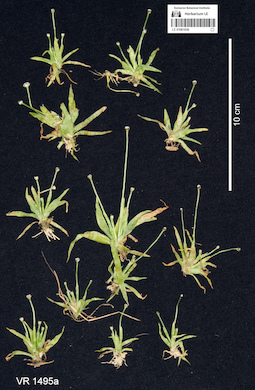
LE 01061036
Eriocaulon duthiei Hook.f. ⟮prelim. ID⟯ det. Averyanov, Leonid Vladimirovich at 10.12.2019
Collectors: Averyanov, Leonid Vladimirovich; Khang Sinh Nguyen; Maisak, Tatiana Viktorovna Field collecting number: VR1495a. Collection date: 09.10.2019. Administrative regions: VN - Tinh Ha Giang. Groups of specimens: L. V. Averyanov specimens; L. V. Averyanov photosOriginal label text:FLORA OF VIETNAM
Coordinates (geographic position): 23° 2′ 6.47″ N, 104° 52′ 12.58″ E ±1000 mComment: Eriocaulaceae
Eriocaulon duthiei Hook.f.?
Ha Giang Prov., Quan Ba Distr., Ta Van Commune, Can Ho Village, around point 23.03513ºN 104.87016ºE, steep rocky mountain slopes composed of eroded limestone at elevation 1100–1250 m a.s.l. Secondary evergreen broad-leaved humid forest. Terrestrial herb in open grassy place at the base of mountain. Inflorescences white. Common. 9 October 2019, L. Averyanov, Nguyen Sinh Khang, T. Maisak, VR 1495a.
All photos © L. Averyanov & K.S. Nguyen
Record creation: 2020-01-02, Аверьянов Леонид ВладимировичCitation: Specimen LE 01061036 // Virtual herbarium of Komarov Botanical Institute RAS — http://re.herbariumle.ru/01061036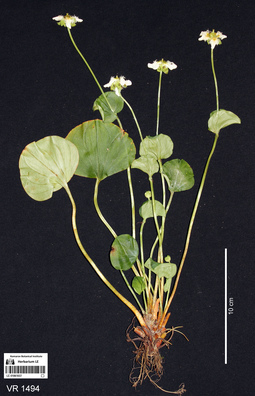
LE 01061037
Parnassia wightiana Wight & Arn. det. Averyanov, Leonid Vladimirovich at 09.10.2019
Collectors: Averyanov, Leonid Vladimirovich; Khang Sinh Nguyen; Maisak, Tatiana Viktorovna Field collecting number: VR1494. Collection date: 09.10.2019. Administrative regions: VN - Tinh Ha Giang. Groups of specimens: L. V. Averyanov specimens; L. V. Averyanov photosOriginal label text:FLORA OF VIETNAM
Coordinates (geographic position): 23° 2′ 6.47″ N, 104° 52′ 12.58″ E ±1000 mComment: Parnassiaceae
Parnassia wightiana Wall.
Ha Giang Prov., Quan Ba Distr., Ta Van Commune, Can Ho Village, around point 23.03513ºN 104.87016ºE, steep rocky mountain slopes composed of eroded limestone at elevation 1100–1250 m a.s.l. Secondary evergreen broad-leaved humid forest along rocky stream. Terrestrial and lithophytic herb on open wet mossy stream rocks. Flowers white. Common. 9 October 2019, L. Averyanov, Nguyen Sinh Khang, T. Maisak, VR 1494.
All photos © L. Averyanov & K.S. Nguyen
Record creation: 2020-01-02, Аверьянов Леонид ВладимировичCitation: Specimen LE 01061037 // Virtual herbarium of Komarov Botanical Institute RAS — http://re.herbariumle.ru/01061037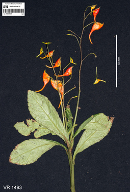
LE 01061038
Impatiens sp. det. Averyanov, Leonid Vladimirovich at 09.10.2019
Collectors: Averyanov, Leonid Vladimirovich; Khang Sinh Nguyen; Maisak, Tatiana Viktorovna Field collecting number: VR1493. Collection date: 09.10.2019. Administrative regions: VN - Tinh Ha Giang. Groups of specimens: L. V. Averyanov specimens; L. V. Averyanov photosOriginal label text:FLORA OF VIETNAM
Coordinates (geographic position): 23° 2′ 6.47″ N, 104° 52′ 12.58″ E ±1000 mComment: Balsaminaceae
Impatiens sp.
Ha Giang Prov., Quan Ba Distr., Ta Van Commune, Can Ho Village, around point 23.03513ºN 104.87016ºE, steep rocky mountain slopes composed of eroded limestone at elevation 1100–1250 m a.s.l. near mountain top. Secondary evergreen broad-leaved humid forest. Terrestrial herb to 1 m tall in open rocky place. Flowers orange. Not common. 9 October 2019, L. Averyanov, Nguyen Sinh Khang, T. Maisak, VR 1493.
All photos © L. Averyanov & K.S. Nguyen
Record creation: 2020-01-02, Аверьянов Леонид ВладимировичCitation: Specimen LE 01061038 // Virtual herbarium of Komarov Botanical Institute RAS — http://re.herbariumle.ru/01061038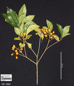
LE 01061039
Pittosporum glabratum Lindl. det. Averyanov, Leonid Vladimirovich at 10.12.2019
Collectors: Averyanov, Leonid Vladimirovich; Khang Sinh Nguyen; Maisak, Tatiana Viktorovna Field collecting number: VR1492. Collection date: 09.10.2019. Administrative regions: VN - Tinh Ha Giang. Groups of specimens: L. V. Averyanov specimens; L. V. Averyanov photosOriginal label text:FLORA OF VIETNAM
Coordinates (geographic position): 23° 2′ 6.47″ N, 104° 52′ 12.58″ E ±1000 mComment: Pittosporaceae
Pittosporum glabratum Lindl.
Ha Giang Prov., Quan Ba Distr., Ta Van Commune, Can Ho Village, around point 23.03513ºN 104.87016ºE, steep rocky mountain slopes composed of eroded limestone at elevation 1100–1250 m a.s.l. near mountain top. Secondary evergreen broad-leaved humid forest. Shrub 2 m tall in open rocky place. Fruits dull yellowish, seeds red. Common. 9 October 2019, L. Averyanov, Nguyen Sinh Khang, T. Maisak, VR 1492.
All photos © L. Averyanov & K.S. Nguyen
Record creation: 2020-01-02, Аверьянов Леонид ВладимировичCitation: Specimen LE 01061039 // Virtual herbarium of Komarov Botanical Institute RAS — http://re.herbariumle.ru/01061039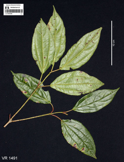
LE 01061040
Viburnum sp. det. Averyanov, Leonid Vladimirovich, Khang Sinh Nguyen at 10.12.2019
Collectors: Averyanov, Leonid Vladimirovich; Khang Sinh Nguyen; Maisak, Tatiana Viktorovna Field collecting number: VR1491. Collection date: 09.10.2019. Administrative regions: VN - Tinh Ha Giang. Groups of specimens: L. V. Averyanov specimens; L. V. Averyanov photosOriginal label text:FLORA OF VIETNAM
Coordinates (geographic position): 23° 2′ 6.47″ N, 104° 52′ 12.58″ E ±1000 mComment: Caprifoliaceae
Viburnum sp.
Ha Giang Prov., Quan Ba Distr., Ta Van Commune, Can Ho Village, around point 23.03513ºN 104.87016ºE, steep rocky mountain slopes composed of eroded limestone at elevation 1100–1250 m a.s.l. near mountain top. Secondary evergreen broad-leaved humid forest. Tree 5-7 m tall and 5-7 cm in diameter with very hard timber locally used for handicrafts. Very common. 9 October 2019, L. Averyanov, Nguyen Sinh Khang, T. Maisak, VR 1491.
All photos © L. Averyanov & K.S. Nguyen
Record creation: 2020-01-02, Аверьянов Леонид ВладимировичCitation: Specimen LE 01061040 // Virtual herbarium of Komarov Botanical Institute RAS — http://re.herbariumle.ru/01061040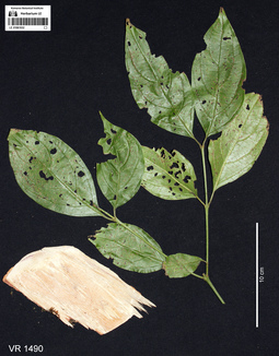
LE 01061032
Cornus sp. ⟮prelim. ID⟯ det. Averyanov, Leonid Vladimirovich at 10.12.2019
Collectors: Averyanov, Leonid Vladimirovich; Khang Sinh Nguyen; Maisak, Tatiana Viktorovna Field collecting number: VR1490. Collection date: 09.10.2019. Administrative regions: VN - Tinh Ha Giang. Groups of specimens: L. V. Averyanov specimens; L. V. Averyanov photosOriginal label text:FLORA OF VIETNAM
Coordinates (geographic position): 23° 2′ 6.47″ N, 104° 52′ 12.58″ E ±1000 mComment: Cornaceae
Cornus sp.
Ha Giang Prov., Quan Ba Distr., Ta Van Commune, Can Ho Village, around point 23.03513ºN 104.87016ºE, steep rocky mountain slopes composed of eroded limestone at elevation 1100–1250 m a.s.l. near mountain top. Secondary evergreen broad-leaved humid forest. Tree to 15 m tall and 20 cm in diam. Timber very hard with black nuclear timber. Common. 9 October 2019, L. Averyanov, Nguyen Sinh Khang, T. Maisak, VR 1490.
All photos © L. Averyanov & K.S. Nguyen
Record creation: 2020-01-02, Аверьянов Леонид ВладимировичCitation: Specimen LE 01061032 // Virtual herbarium of Komarov Botanical Institute RAS — http://re.herbariumle.ru/01061032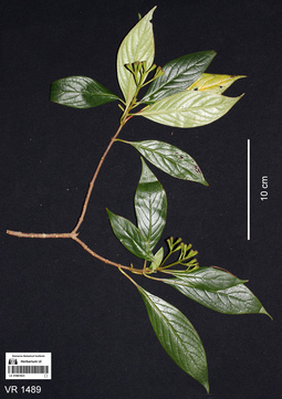
LE 01061023
Mussaenda sp. det. Averyanov, Leonid Vladimirovich at 08.12.2020
Additional identifications: Psychotria sp. det. Averyanov, Leonid Vladimirovich, Khang Sinh Nguyen at 09.10.2019 Collectors: Averyanov, Leonid Vladimirovich; Khang Sinh Nguyen; Maisak, Tatiana Viktorovna Field collecting number: VR1489. Collection date: 09.10.2019. Administrative regions: VN - Tinh Ha Giang. Groups of specimens: L. V. Averyanov specimens; L. V. Averyanov photosOriginal label text:FLORA OF VIETNAM
Coordinates (geographic position): 23° 2′ 6.47″ N, 104° 52′ 12.58″ E ±1000 mComment: Rubiaceae
Psychotria sp.?
Ha Giang Prov., Quan Ba Distr., Ta Van Commune, Can Ho Village, around point 23.03513ºN 104.87016ºE, steep rocky mountain slopes composed of eroded limestone at elevation 1100–1250 m a.s.l. near mountain top. Secondary evergreen broad-leaved humid forest. Shrub 2-3 m tall in open rocky place. Common. 9 October 2019, L. Averyanov, Nguyen Sinh Khang, T. Maisak, VR 1489.
All photos © L. Averyanov & K.S. Nguyen
Record creation: 2020-01-02, Аверьянов Леонид ВладимировичCitation: Specimen LE 01061023 // Virtual herbarium of Komarov Botanical Institute RAS — http://re.herbariumle.ru/01061023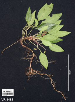
LE 01061024
Viola annamensis Baker f. det. Averyanov, Leonid Vladimirovich at 09.10.2019
Collectors: Averyanov, Leonid Vladimirovich; Khang Sinh Nguyen; Maisak, Tatiana Viktorovna Field collecting number: VR1488. Collection date: 09.10.2019. Administrative regions: VN - Tinh Ha Giang. Groups of specimens: L. V. Averyanov specimens; L. V. Averyanov photosOriginal label text:FLORA OF VIETNAM
Coordinates (geographic position): 23° 2′ 6.47″ N, 104° 52′ 12.58″ E ±1000 mComment: Violaceae
Viola annamensis Baker f.
Ha Giang Prov., Quan Ba Distr., Ta Van Commune, Can Ho Village, around point 23.03513ºN 104.87016ºE, steep rocky mountain slopes composed of eroded limestone at elevation 1100–1250 m a.s.l. near mountain top. Secondary evergreen broad-leaved humid forest. Terrestrial herb in open rocky place. Common. 9 October 2019, L. Averyanov, Nguyen Sinh Khang, T. Maisak, VR 1488.
All photos © L. Averyanov & K.S. Nguyen
Record creation: 2020-01-02, Аверьянов Леонид ВладимировичCitation: Specimen LE 01061024 // Virtual herbarium of Komarov Botanical Institute RAS — http://re.herbariumle.ru/01061024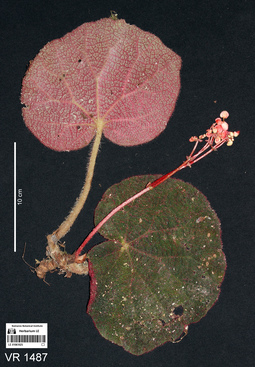
LE 01061025
Begonia rhytidophylla Y.M.Shui & W.H.Chen det. Yu-Min Shui at 20.12.2019
Collectors: Averyanov, Leonid Vladimirovich; Khang Sinh Nguyen; Maisak, Tatiana Viktorovna Field collecting number: VR1487. Collection date: 09.10.2019. Administrative regions: VN - Tinh Ha Giang. Groups of specimens: L. V. Averyanov specimens; L. V. Averyanov photosOriginal label text:FLORA OF VIETNAM
Coordinates (geographic position): 23° 2′ 6.47″ N, 104° 52′ 12.58″ E ±1000 mComment: Begoniaceae
Begonia rhytidophylla Y.M. Shui & W.H. Chen
Ha Giang Prov., Quan Ba Distr., Ta Van Commune, Can Ho Village, around point 23.03513ºN 104.87016ºE, steep rocky mountain slopes composed of eroded limestone at elevation 1100–1250 m a.s.l. near mountain top. Secondary evergreen broad-leaved humid forest. Lithophytic rosulate herb on vertical cliffs. Leaves dark purple on both sides. Locally common. 9 October 2019, L. Averyanov, Nguyen Sinh Khang, T. Maisak, VR 1487. Det.: Yu-Min Shui 20.12.2019
All photos © L. Averyanov & K.S. Nguyen
Record creation: 2020-01-02, Аверьянов Леонид ВладимировичCitation: Specimen LE 01061025 // Virtual herbarium of Komarov Botanical Institute RAS — http://re.herbariumle.ru/01061025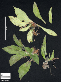
LE 01061026
Chirita sp. det. Averyanov, Leonid Vladimirovich at 09.10.2019
Collectors: Averyanov, Leonid Vladimirovich; Khang Sinh Nguyen; Maisak, Tatiana Viktorovna Field collecting number: VR1486. Collection date: 09.10.2019. Administrative regions: VN - Tinh Ha Giang. Groups of specimens: L. V. Averyanov specimens; L. V. Averyanov photosOriginal label text:FLORA OF VIETNAM
Coordinates (geographic position): 23° 2′ 6.47″ N, 104° 52′ 12.58″ E ±1000 mComment: Gesneriaceae
Chirita sp.
Ha Giang Prov., Quan Ba Distr., Ta Van Commune, Can Ho Village, around point 23.03513ºN 104.87016ºE, steep rocky mountain slopes composed of eroded limestone at elevation 1100–1250 m a.s.l. near mountain top. Secondary evergreen broad-leaved humid forest. Lithophytic rosulate herb on vertical cliffs. Locally common. 9 October 2019, L. Averyanov, Nguyen Sinh Khang, T. Maisak, VR 1486.
All photos © L. Averyanov & K.S. Nguyen
Record creation: 2020-01-02, Аверьянов Леонид ВладимировичCitation: Specimen LE 01061026 // Virtual herbarium of Komarov Botanical Institute RAS — http://re.herbariumle.ru/01061026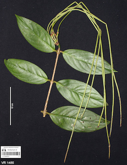
LE 01061027
Aeschynanthus superbus C.B.Clarke det. Averyanov, Leonid Vladimirovich at 09.10.2019
Collectors: Averyanov, Leonid Vladimirovich; Khang Sinh Nguyen; Maisak, Tatiana Viktorovna Field collecting number: VR1485. Collection date: 09.10.2019. Administrative regions: VN - Tinh Ha Giang. Groups of specimens: L. V. Averyanov specimens; L. V. Averyanov photosOriginal label text:FLORA OF VIETNAM
Coordinates (geographic position): 23° 2′ 6.47″ N, 104° 52′ 12.58″ E ±1000 mComment: Gesneriaceae
Aeschynanthus superbus C.B. Clarke
Ha Giang Prov., Quan Ba Distr., Ta Van Commune, Can Ho Village, around point 23.03513ºN 104.87016ºE, steep rocky mountain slopes composed of eroded limestone at elevation 1100–1250 m a.s.l. near mountain top. Secondary evergreen broad-leaved humid forest. Epiphytic scandent undershrub on old mossy tree. Fruits green. Occasional. 9 October 2019, L. Averyanov, Nguyen Sinh Khang, T. Maisak, VR 1485.
All photos © L. Averyanov & K.S. Nguyen
Record creation: 2020-01-02, Аверьянов Леонид ВладимировичCitation: Specimen LE 01061027 // Virtual herbarium of Komarov Botanical Institute RAS — http://re.herbariumle.ru/01061027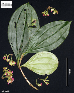
LE 01061028
Medinilla petelotii Merr. det. Averyanov, Leonid Vladimirovich at 10.12.2019
Collectors: Averyanov, Leonid Vladimirovich; Khang Sinh Nguyen; Maisak, Tatiana Viktorovna Field collecting number: VR1484. Collection date: 09.10.2019. Administrative regions: VN - Tinh Ha Giang. Groups of specimens: L. V. Averyanov specimens; L. V. Averyanov photosOriginal label text:FLORA OF VIETNAM
Coordinates (geographic position): 23° 2′ 6.47″ N, 104° 52′ 12.58″ E ±1000 mComment: Melastomataceae
Medinilla petelotii Merr.
Ha Giang Prov., Quan Ba Distr., Ta Van Commune, Can Ho Village, around point 23.03513ºN 104.87016ºE, steep rocky mountain slopes composed of eroded limestone at elevation 1100–1250 m a.s.l. near mountain top. Secondary evergreen broad-leaved humid forest. Epiphytic scandent undershrub on old mossy tree. Flowers pink to pink-purple. Common. 9 October 2019, L. Averyanov, Nguyen Sinh Khang, T. Maisak, VR 1484.
All photos © L. Averyanov & K.S. Nguyen
Record creation: 2020-01-02, Аверьянов Леонид ВладимировичCitation: Specimen LE 01061028 // Virtual herbarium of Komarov Botanical Institute RAS — http://re.herbariumle.ru/01061028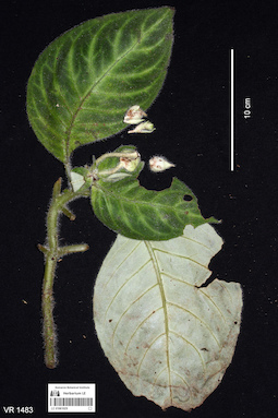
LE 01061029
Hemiboea ovalifolia (W.T.Wang) A.Weber & Mich.Möller det. Averyanov, Leonid Vladimirovich at 10.12.2019
Collectors: Averyanov, Leonid Vladimirovich; Khang Sinh Nguyen; Maisak, Tatiana Viktorovna Field collecting number: VR1483. Collection date: 09.10.2019. Administrative regions: VN - Tinh Ha Giang. Groups of specimens: L. V. Averyanov specimens; L. V. Averyanov photosOriginal label text:FLORA OF VIETNAM
Coordinates (geographic position): 23° 2′ 6.47″ N, 104° 52′ 12.58″ E ±1000 mComment: Gesneriaceae
Hemiboea ovalifolia (W.T. Wang) A. Weber & Mich. Möller
Ha Giang Prov., Quan Ba Distr., Ta Van Commune, Can Ho Village, around point 23.03513ºN 104.87016ºE, steep rocky mountain slopes composed of eroded limestone at elevation 1100–1250 m a.s.l. near mountain top. Secondary evergreen broad-leaved humid forest. Terrestrial herb among mossy rocks. Leaves dark green, pale green below. Very common. 9 October 2019, L. Averyanov, Nguyen Sinh Khang, T. Maisak, VR 1483.
All photos © L. Averyanov & K.S. Nguyen
Record creation: 2020-01-02, Аверьянов Леонид ВладимировичCitation: Specimen LE 01061029 // Virtual herbarium of Komarov Botanical Institute RAS — http://re.herbariumle.ru/01061029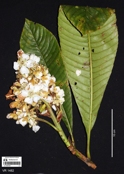
LE 01061030
Eriobotrya elliptica Lindl. det. Averyanov, Leonid Vladimirovich at 10.12.2019
Collectors: Averyanov, Leonid Vladimirovich; Khang Sinh Nguyen; Maisak, Tatiana Viktorovna Field collecting number: VR1482. Collection date: 09.10.2019. Administrative regions: VN - Tinh Ha Giang. Groups of specimens: L. V. Averyanov specimens; L. V. Averyanov photosOriginal label text:FLORA OF VIETNAM
Coordinates (geographic position): 23° 2′ 6.47″ N, 104° 52′ 12.58″ E ±1000 mComment: Rosaceae
Eriobotrya elliptica Lindl.
Ha Giang Prov., Quan Ba Distr., Ta Van Commune, Can Ho Village, around point 23.03513ºN 104.87016ºE, steep rocky mountain slopes composed of eroded limestone at elevation 1100–1250 m a.s.l. near mountain top. Secondary evergreen broad-leaved humid forest. Tree to 20 m tall and to 20 cm in diameter. Flowers pure white, very fragrant. Very common. Timber of good quality. 9 October 2019, L. Averyanov, Nguyen Sinh Khang, T. Maisak, VR 1482.
All photos © L. Averyanov & K.S. Nguyen
Record creation: 2020-01-02, Аверьянов Леонид ВладимировичCitation: Specimen LE 01061030 // Virtual herbarium of Komarov Botanical Institute RAS — http://re.herbariumle.ru/01061030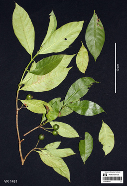
LE 01061031
Aidia pycnantha (Drake) Tirveng. det. Averyanov, Leonid Vladimirovich at 08.12.2020
Additional identifications: Aidia sp. det. Averyanov, Leonid Vladimirovich, Khang Sinh Nguyen at 09.10.2019 Collectors: Averyanov, Leonid Vladimirovich; Khang Sinh Nguyen; Maisak, Tatiana Viktorovna Field collecting number: VR1481. Collection date: 09.10.2019. Administrative regions: VN - Tinh Ha Giang. Groups of specimens: L. V. Averyanov specimens; L. V. Averyanov photosOriginal label text:FLORA OF VIETNAM
Coordinates (geographic position): 23° 2′ 6.47″ N, 104° 52′ 12.58″ E ±1000 mComment: Rubiaceae
Aidia sp.?
Ha Giang Prov., Quan Ba Distr., Ta Van Commune, Can Ho Village, around point 23.03513ºN 104.87016ºE, steep rocky mountain slopes composed of eroded limestone at elevation 1100–1250 m a.s.l. near mountain top. Secondary evergreen broad-leaved humid forest. Shrub about 3 m tall in open place. Fruits dark green. Common. 9 October 2019, L. Averyanov, Nguyen Sinh Khang, T. Maisak, VR 1481.
All photos © L. Averyanov & K.S. Nguyen
Record creation: 2020-01-02, Аверьянов Леонид ВладимировичCitation: Specimen LE 01061031 // Virtual herbarium of Komarov Botanical Institute RAS — http://re.herbariumle.ru/01061031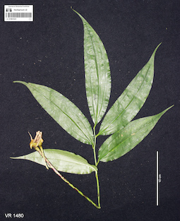
LE 01061022
Disporopsis longifolia Craib det. Averyanov, Leonid Vladimirovich at 09.10.2019
Collectors: Averyanov, Leonid Vladimirovich; Khang Sinh Nguyen; Maisak, Tatiana Viktorovna Field collecting number: VR1480. Collection date: 09.10.2019. Administrative regions: VN - Tinh Ha Giang. Groups of specimens: L. V. Averyanov specimens; L. V. Averyanov photosOriginal label text:FLORA OF VIETNAM
Coordinates (geographic position): 23° 2′ 6.47″ N, 104° 52′ 12.58″ E ±1000 mComment: Convallariaceae
Disporopsis longifolia Craib
Ha Giang Prov., Quan Ba Distr., Ta Van Commune, Can Ho Village, around point 23.03513ºN 104.87016ºE, steep rocky mountain slopes composed of eroded limestone at elevation 1100–1250 m a.s.l. near mountain top. Secondary evergreen broad-leaved humid forest. Terrestrial and lithophytic creeping herb. Petiole with dirty purple punctuation. Not common. Widely collected as medicinal plant. 9 October 2019, L. Averyanov, Nguyen Sinh Khang, T. Maisak, VR 1480.
All photos © L. Averyanov & K.S. Nguyen
Record creation: 2020-01-02, Аверьянов Леонид ВладимировичCitation: Specimen LE 01061022 // Virtual herbarium of Komarov Botanical Institute RAS — http://re.herbariumle.ru/01061022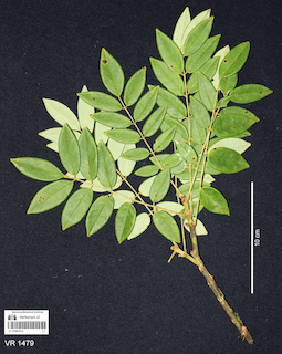
LE 01061013
Ormosia sp. det. Sawai Mattapha at 29.11.2019
Collectors: Averyanov, Leonid Vladimirovich; Khang Sinh Nguyen; Maisak, Tatiana Viktorovna Field collecting number: VR1479. Collection date: 09.10.2019. Administrative regions: VN - Tinh Ha Giang. Groups of specimens: L. V. Averyanov specimens; L. V. Averyanov photosOriginal label text:FLORA OF VIETNAM
Coordinates (geographic position): 23° 2′ 6.47″ N, 104° 52′ 12.58″ E ±1000 mComment: Fabaceae
Ormosia sp.
Ha Giang Prov., Quan Ba Distr., Ta Van Commune, Can Ho Village, around point 23.03513ºN 104.87016ºE, steep rocky mountain slopes composed of eroded limestone at elevation 1100–1250 m a.s.l. near mountain top. Secondary evergreen broad-leaved humid forest. Shrub or small tree 5-7 m tall and 7 cm in diameter. Timber is very hard. Common, but widely logged for the timber sale (very expensive). 9 October 2019, L. Averyanov, Nguyen Sinh Khang, T. Maisak, VR 1479. Det.: Sawai Mattapha 29.11.2019
All photos © L. Averyanov & K.S. Nguyen
Record creation: 2020-01-02, Аверьянов Леонид ВладимировичCitation: Specimen LE 01061013 // Virtual herbarium of Komarov Botanical Institute RAS — http://re.herbariumle.ru/01061013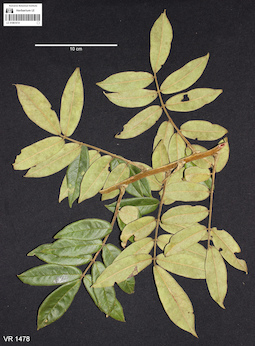
LE 01061014
Callerya dasyphylla (Miq.) Schot det. Sawai Mattapha at 29.11.2019
Additional identifications: Padbruggea dasyphylla Miq. det. Sawai Mattapha at 29.11.2019 Collectors: Averyanov, Leonid Vladimirovich; Khang Sinh Nguyen; Maisak, Tatiana Viktorovna Field collecting number: VR1478. Collection date: 09.10.2019. Administrative regions: VN - Tinh Ha Giang. Groups of specimens: L. V. Averyanov specimens; L. V. Averyanov photosOriginal label text:FLORA OF VIETNAM
Coordinates (geographic position): 23° 2′ 6.47″ N, 104° 52′ 12.58″ E ±1000 mComment: Fabaceae
Padbruggea dasyphylla Miq. ( = Callerya dasyphylla (Miq.) Schot)
Ha Giang Prov., Quan Ba Distr., Ta Van Commune, Can Ho Village, around point 23.03513ºN 104.87016ºE, steep rocky mountain slopes composed of eroded limestone at elevation 1100–1250 m a.s.l. near mountain top. Secondary evergreen broad-leaved humid forest. Woody vine to 15 m long and 7 cm in diameter, timber and bark with red juice. Fruits velvety hairy, yellow-greenish. Locally used as medicinal plant (with alcohol). Common. 9 October 2019, L. Averyanov, Nguyen Sinh Khang, T. Maisak, VR 1478. Det.: Sawai Mattapha 29.11.2019
All photos © L. Averyanov & K.S. Nguyen
Record creation: 2020-01-02, Аверьянов Леонид ВладимировичCitation: Specimen LE 01061014 // Virtual herbarium of Komarov Botanical Institute RAS — http://re.herbariumle.ru/01061014