View
Add
Copy
Edit
Delete
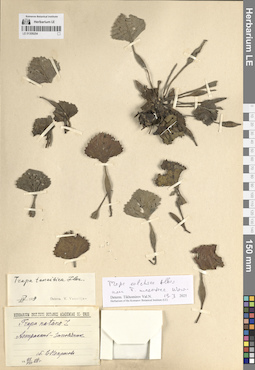
LE 01309254
Trapa natans L. det. Nekrasova, Vera Leontievna at 23.08.1928
Additional identifications: Trapa tanaitica Flerow det. Vassiljev, Viktor Nikolayevich at 04.1959; Trapa colchica Albov det. Tikhomirov, Valery Nikolaevich at 19.03.2025; Trapa maeotica Woronow det. Tikhomirov, Valery Nikolaevich at 19.03.2025 Collectors: Nekrasova, Vera Leontievna Collection date: 23.08.1928. Administrative regions: RU - Astrakhanskaya Oblast' - Kamyzyakskiy Rayon. Subregion: Образцово-Травинский сельсовет. Топоним: Волжский заповедник (Астраханский биосферный заповедник). Place of collection: дельта реки Волга.Groups of specimens: Образцы сектора Восточной Европы; Herbarium Instituti Botanici Academiae Sc. URSSLife form: hydrophyteOriginal label text:Астрахань - заповедник
Landscape in location of collection: степиHabitat / plant community in location of collecting: прибрежная зона рекиSubstrate in collecting location: siltCoordinates (geographic position): 45° 47′ 44.74″ N, 47° 53′ 31.4″ ERecord creation: 2025-06-03, Denis Melnikov, PhotoScan D2Citation: Specimen LE 01309254 // Virtual herbarium of Komarov Botanical Institute RAS — http://re.herbariumle.ru/01309254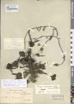
LE 01309253
Trapa tanaitica Flerow det. Vassiljev, Viktor Nikolayevich at 04.1959
Additional identifications: Trapa astrachanica (Flerow) N.A. Winter det. Tzvelev, Nikolai Nikolaievich at 1990; Trapa colchica Albov det. Tikhomirov, Valery Nikolaevich at 19.03.2025; Trapa maeotica Woronow det. Tikhomirov, Valery Nikolaevich at 19.03.2025 Collectors: Korshinsky, Sergei Ivanovitsch Administrative regions: RU - Astrakhanskaya Oblast' - Kamyzyakskiy Rayon. Subregion: Николо-Комаровский сельсовет. Топоним: река Чилимная, Камызякский район, Астраханская область. Place of collection: дельта реки Волга.Groups of specimens: Образцы сектора Восточной Европы; Herbarium Academiae Scientiarum Petropol.; Флора дельты реки Волги; Herbarium of the Komarov Botanical Institute (LE)Life form: hydrophyteOriginal label text:На реке Чилимной.
Landscape in location of collection: степиHabitat / plant community in location of collecting: прибрежная зона рекиSubstrate in collecting location: siltCoordinates (geographic position): 46° 8′ 47.93″ N, 47° 51′ 38.07″ ERecord creation: 2025-06-03, Denis Melnikov, PhotoScan D2Citation: Specimen LE 01309253 // Virtual herbarium of Komarov Botanical Institute RAS — http://re.herbariumle.ru/01309253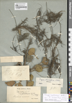
LE 01309252
Trapa natans L. det. Korshinsky, Sergei Ivanovitsch
Additional identifications: Trapa tanaitica Flerow det. Vassiljev, Viktor Nikolayevich at 1947; Trapa colchica Albov det. Tikhomirov, Valery Nikolaevich at 19.03.2025; Trapa maeotica Woronow det. Tikhomirov, Valery Nikolaevich at 19.03.2025 Collectors: Korshinsky, Sergei Ivanovitsch Administrative regions: RU - Astrakhanskaya Oblast' - Kamyzyakskiy Rayon. Subregion: Караулинский сельсовет. Топоним: остров (ильмень) Кабаний, Астраханская область. Place of collection: дельта реки Волга.Groups of specimens: Образцы сектора Восточной Европы; Флора дельты реки Волги; Herbarium of the Komarov Botanical Institute (LE)Life form: hydrophyteOriginal label text:Кабаний ильмень.
Landscape in location of collection: степиHabitat / plant community in location of collecting: в воде ильменяSubstrate in collecting location: siltCoordinates (geographic position): 45° 51′ 23.02″ N, 48° 13′ 1.25″ ERecord creation: 2025-06-03, Denis Melnikov, PhotoScan D2Citation: Specimen LE 01309252 // Virtual herbarium of Komarov Botanical Institute RAS — http://re.herbariumle.ru/01309252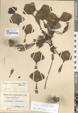
LE 01309251
Trapa natans L. det. Nekrasova, Vera Leontievna at 28.08.1928
Additional identifications: Trapa astrachanica (Flerow) N.A. Winter det. Vassiljev, Viktor Nikolayevich at 04.1959; Trapa colchica Albov det. Tikhomirov, Valery Nikolaevich at 19.03.2025 Collectors: Nekrasova, Vera Leontievna Collection date: 28.08.1928. Administrative regions: RU - Astrakhanskaya Oblast' - Kamyzyakskiy Rayon. Subregion: Образцово-Травинский сельсовет. Топоним: Волжский заповедник (Астраханский биосферный заповедник). Place of collection: дельта реки Волга.Groups of specimens: Образцы сектора Восточной Европы; Herbarium Instituti Botanici Academiae Sc. URSS; Herbarium of the Komarov Botanical Institute (LE)Life form: hydrophyteOriginal label text:Астрахань, заповедник
Landscape in location of collection: степиHabitat / plant community in location of collecting: в прибрежной зоне рекиSubstrate in collecting location: siltCoordinates (geographic position): 45° 47′ 44.74″ N, 47° 53′ 31.4″ ERecord creation: 2025-06-03, Denis Melnikov, PhotoScan D2Citation: Specimen LE 01309251 // Virtual herbarium of Komarov Botanical Institute RAS — http://re.herbariumle.ru/01309251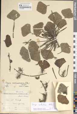
LE 01309250
Trapa astrachanica (Flerow) N.A. Winter det. Vassiljev, Viktor Nikolayevich at 1947
Additional identifications: Trapa colchica Albov det. Tikhomirov, Valery Nikolaevich at 19.03.2025 Collectors: Fischer von Waldheim, (Johann) Gotthelf Administrative regions: KZ - Atyrau Oblysy. Subregion: город Атырау. Топоним: город Атырау, Казахстан. Place of collection: устье реки Урал.Groups of specimens: Образцы сектора Восточной Европы; Herbarium Instituti Botanici Academiae Sc. URSS; Herbarium of the Komarov Botanical Institute (LE); Herb. FischerLife form: hydrophyteOriginal label text:Ins. ad Gurief. Устье Урала
Landscape in location of collection: степиHabitat / plant community in location of collecting: в прибрежной зоне рекиSubstrate in collecting location: siltCoordinates (geographic position): 47° 6′ 27.45″ N, 51° 54′ 58.88″ ERecord creation: 2025-06-03, Denis Melnikov, PhotoScan D2Citation: Specimen LE 01309250 // Virtual herbarium of Komarov Botanical Institute RAS — http://re.herbariumle.ru/01309250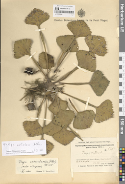
LE 01309249
Trapa natans L. det. Kosinskiy (Kossinski), Konstantin Konstantinovich at 20.07.1915
Additional identifications: Trapa astrachanica (Flerow) N.A. Winter det. Vassiljev, Viktor Nikolayevich at 05.1960; Trapa colchica Albov det. Tikhomirov, Valery Nikolaevich at 19.03.2025 Collectors: Kosinskiy (Kossinski), Konstantin Konstantinovich Field collecting number: 565. Collection date: 20.07.1915. Administrative regions: RU - Astrakhanskaya Oblast' - Kamyzyakskiy Rayon. Subregion: Самосдельский сельсовет. Топоним: ильмень Дангар, Астраханская область. Place of collection: дельта реки Волга.Expedition: Научно-промысловая экспедиция по исследованию дельты Волги (1914 -1915)Groups of specimens: Образцы сектора Восточной Европы; Hortus Botanicus Imperialis Petri Magni.; Herbarium Horti botanici Imperialis Petri Magni; C. Kossinski. Plantae ad ostia Volgae lectae 1915.; Herbarium of the Komarov Botanical Institute (LE)Life form: hydrophyteObject features: плоды недозрелыеOriginal label text:Астраханская губерния, дельта Волги, ильмень Дангар
Landscape in location of collection: степиHabitat / plant community in location of collecting: в воде ильменяSubstrate in collecting location: siltCoordinates (geographic position): 45° 56′ 34.07″ N, 47° 51′ 15.05″ ERecord creation: 2025-06-03, Denis Melnikov, PhotoScan D2Citation: Specimen LE 01309249 // Virtual herbarium of Komarov Botanical Institute RAS — http://re.herbariumle.ru/01309249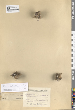
LE 01309248
Trapa astrachanica (Flerow) N.A. Winter det. Vassiljev, Viktor Nikolayevich at 1946
Additional identifications: Trapa colchica Albov det. Tikhomirov, Valery Nikolaevich at 19.03.2025 Collectors: Sprygin, Ivan Ivanovich Administrative regions: RU - Astrakhanskaya Oblast' - Kamyzyakskiy Rayon. Subregion: Образцово-Травинский сельсовет. Топоним: река Волга, низовья. Place of collection: дельта реки Волга, Астраханский заповедник.Groups of specimens: Образцы сектора Восточной Европы; Herbarium Instituti Botanici Academiae Sc. URSS; Herbarium of the Komarov Botanical Institute (LE)Life form: hydrophyteObject features: орехи с сильно развитым дискомOriginal label text:Астраханский заповедник в дельте Волги.
Landscape in location of collection: степиHabitat / plant community in location of collecting: в прибрежной зоне рекиSubstrate in collecting location: siltCoordinates (geographic position): 45° 47′ 37.08″ N, 47° 53′ 28.38″ ERecord creation: 2025-06-03, Denis Melnikov, PhotoScan D2Citation: Specimen LE 01309248 // Virtual herbarium of Komarov Botanical Institute RAS — http://re.herbariumle.ru/01309248
LE 01309247
Trapa astrachanica (Flerow) N.A. Winter det. Vassiljev, Viktor Nikolayevich at 1946
Additional identifications: Trapa colchica Albov det. Tikhomirov, Valery Nikolaevich at 19.03.2025 Collectors: Sprygin, Ivan Ivanovich Administrative regions: RU - Astrakhanskaya Oblast' - Volodarskiy Rayon. Subregion: Калининский сельсовет. Топоним: култук Гранушин, Астраханская область (ильмень култук Григорша). Place of collection: дельта реки Волга, Астраханский заповедник.Groups of specimens: Образцы сектора Восточной Европы; Herbarium Instituti Botanici Academiae Sc. URSS; Herbarium of the Komarov Botanical Institute (LE)Life form: hydrophyteObject features: образования типа ... в первичной ... в виде пятнышек и крохотных бугорковOriginal label text:Дельта Волги култук Гранушина. "Астраханский заповедник".
Landscape in location of collection: степиHabitat / plant community in location of collecting: в воде ильменяSubstrate in collecting location: siltCoordinates (geographic position): 46° 24′ 35.1″ N, 48° 59′ 8.45″ ERecord creation: 2025-06-03, Denis Melnikov, PhotoScan D2Citation: Specimen LE 01309247 // Virtual herbarium of Komarov Botanical Institute RAS — http://re.herbariumle.ru/01309247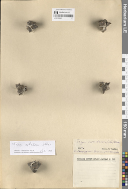
LE 01309246
Trapa astrachanica (Flerow) N.A. Winter det. Vassiljev, Viktor Nikolayevich at 1947
Additional identifications: Trapa colchica Albov det. Tikhomirov, Valery Nikolaevich at 19.03.2025 Collectors: Komarov, Vladimir Leontjevich Collection date: 1904. Administrative regions: RU - Astrakhanskaya Oblast' - Gorod Astrakhan'. Топоним: Astrachan (г. Астрахань). Place of collection: Астрахань.Groups of specimens: Образцы сектора Восточной Европы; Herbarium Instituti Botanici Academiae Sc. URSS; Herbarium of the Komarov Botanical Institute (LE)Life form: hydrophyteOriginal label text:Из Астрахани.
Landscape in location of collection: степиHabitat / plant community in location of collecting: в прибрежной зоне рекиSubstrate in collecting location: siltCoordinates (geographic position): 46° 20′ 51.41″ N, 48° 1′ 48.64″ EComment: Получено от В. Л. Комарова
Record creation: 2025-06-03, Denis Melnikov, PhotoScan D2Citation: Specimen LE 01309246 // Virtual herbarium of Komarov Botanical Institute RAS — http://re.herbariumle.ru/01309246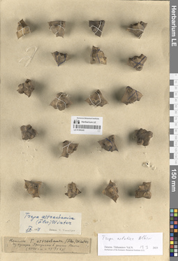
LE 01309245
Trapa astrachanica (Flerow) N.A. Winter det. Vassiljev, Viktor Nikolayevich at 09.1958
Additional identifications: Trapa colchica Albov det. Tikhomirov, Valery Nikolaevich at 19.03.2025 Collectors: Sprygin, Ivan Ivanovich Administrative regions: RU - Astrakhanskaya Oblast' - Volodarskiy Rayon. Subregion: Калининский сельсовет. Топоним: култук Гранушин, Астраханская область (ильмень култук Григорша). Place of collection: дельта реки Волга.Groups of specimens: Образцы сектора Восточной Европы; Herbarium of the Komarov Botanical Institute (LE)Life form: hydrophyteObject features: комплексOriginal label text:Из култука Гранушкина в дельте Волги (45°50' северной широты и 47°53' восточной долготы)
Landscape in location of collection: степиHabitat / plant community in location of collecting: в воде ильменяSubstrate in collecting location: siltCoordinates (geographic position): 46° 24′ 35.1″ N, 48° 59′ 8.45″ ERecord creation: 2025-06-03, Denis Melnikov, PhotoScan D2Citation: Specimen LE 01309245 // Virtual herbarium of Komarov Botanical Institute RAS — http://re.herbariumle.ru/01309245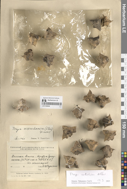
LE 01309244
Trapa astrachanica (Flerow) N.A. Winter det. Vassiljev, Viktor Nikolayevich at 05.1960
Additional identifications: Trapa colchica Albov det. Tikhomirov, Valery Nikolaevich at 19.03.2025 Collectors: Sprygin, Ivan Ivanovich Administrative regions: RU - Astrakhanskaya Oblast' - Volodarskiy Rayon. Subregion: Калининский сельсовет. Топоним: култук Гранушин, Астраханская область (ильмень култук Григорша). Place of collection: дельта реки Волга.Groups of specimens: Образцы сектора Восточной Европы; Гербарий Ботанического Института Академии наук СССР; Herbarium Instituti Botanici Academiae Sc. URSS; Herbarium of the Komarov Botanical Institute (LE)Life form: hydrophyteOriginal label text:Дельта Волги. Култук Гранушкина (45°50' северной широты и 47°53' восточной долготы)
Landscape in location of collection: степиHabitat / plant community in location of collecting: в воде ильменяSubstrate in collecting location: siltCoordinates (geographic position): 46° 24′ 35.1″ N, 48° 59′ 8.45″ ERecord creation: 2025-06-03, Denis Melnikov, PhotoScan D2Citation: Specimen LE 01309244 // Virtual herbarium of Komarov Botanical Institute RAS — http://re.herbariumle.ru/01309244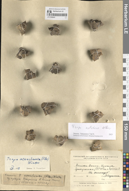
LE 01309243
Trapa astrachanica (Flerow) N.A. Winter det. Sprygin, Ivan Ivanovich
Additional identifications: Trapa astrachanica (Flerow) N.A. Winter det. Vassiljev, Viktor Nikolayevich at 09.1958; Trapa colchica Albov det. Tikhomirov, Valery Nikolaevich at 2025 Collectors: Sprygin, Ivan Ivanovich Administrative regions: RU - Astrakhanskaya Oblast' - Volodarskiy Rayon. Subregion: Калининский сельсовет. Топоним: култук Гранушин, Астраханская область (ильмень култук Григорша). Place of collection: дельта реки Волга.Groups of specimens: Образцы сектора Восточной Европы; Гербарий Ботанического Института Академии наук СССР; Herbarium Instituti Botanici Academiae Sc. URSS; Herbarium of the Komarov Botanical Institute (LE)Life form: hydrophyteObject features: комплексOriginal label text:Дельта Волги. Култук Гранушкина (45°50' северной широты и 47°53' восточной долготы)
Landscape in location of collection: степиHabitat / plant community in location of collecting: в воде ильменяSubstrate in collecting location: siltCoordinates (geographic position): 46° 24′ 35.1″ N, 48° 59′ 8.45″ ERecord creation: 2025-06-03, Denis Melnikov, PhotoScan D2Citation: Specimen LE 01309243 // Virtual herbarium of Komarov Botanical Institute RAS — http://re.herbariumle.ru/01309243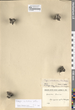
LE 01309242
Trapa astrachanica (Flerow) N.A. Winter det. Vassiljev, Viktor Nikolayevich at 1947
Additional identifications: Trapa colchica Albov det. Tikhomirov, Valery Nikolaevich at 19.03.2025 Collectors: Komarov, Vladimir Leontjevich Collection date: 1907. Administrative regions: RU - Astrakhanskaya Oblast'; KZ - Atyrau Oblysy. Топоним: река Волга, низовья. Place of collection: дельта реки Волга.Groups of specimens: Образцы сектора Восточной Европы; Herbarium Instituti Botanici Academiae Sc. URSS; Herbarium of the Komarov Botanical Institute (LE)Life form: hydrophyteOriginal label text:Дельта Волги.
Landscape in location of collection: степиHabitat / plant community in location of collecting: в прибрежной зоне водоемаSubstrate in collecting location: siltComment: Получено от В. Л. Комарова
Record creation: 2025-06-03, Denis Melnikov, PhotoScan D2Citation: Specimen LE 01309242 // Virtual herbarium of Komarov Botanical Institute RAS — http://re.herbariumle.ru/01309242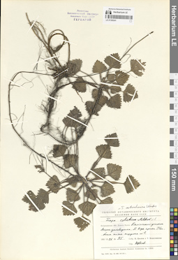
LE 01309241
Trapa astrachanica (Flerow) N.A. Winter det. Tzvelev, Nikolai Nikolaievich at 26.07.1965
Collectors: Tzvelev, Nikolai Nikolaievich; Kolesnikova, Tatiana Field collecting number: 95. Collection date: 26.07.1965. Administrative regions: RU - Astrakhanskaya Oblast' - Kamyzyakskiy Rayon. Subregion: Образцово-Травинский сельсовет. Топоним: ерик Колбин, Астраханская область. Place of collection: дельта реки Волга, Дамчикский участок Астраханского заповедника, ниже кордона №1.Groups of specimens: Образцы сектора Восточной Европы; Гербарий Ботанического Института Академии наук СССР; Herbarium Instituti Botanici Academiae Sc. URSS; Ленинград. Ботанический институт Академии Наук СССР. Гербарий.Life form: hydrophyteOriginal label text:Астраханская область Дельта Волги. Дамчикский участок Астраханского заповедника. В воде ерика Колбина ниже кордона №1.
Landscape in location of collection: степиHabitat / plant community in location of collecting: в воде ерикаSubstrate in collecting location: siltCoordinates (geographic position): 45° 50′ 17.97″ N, 47° 53′ 9.99″ ERecord creation: 2025-06-03, Denis Melnikov, PhotoScan D2Citation: Specimen LE 01309241 // Virtual herbarium of Komarov Botanical Institute RAS — http://re.herbariumle.ru/01309241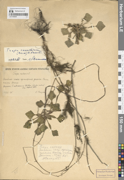
LE 01309240
Trapa natans L. det. Sakharova, N. at 14.07.1925
Additional identifications: Trapa carinthiaca (Beck) V.N. Vassil. det. Vassiljev, Viktor Nikolayevich at 20.07.1959; Trapa astrachanica (Flerow) N.A. Winter ⟮prelim. ID⟯ det. Tzvelev, Nikolai Nikolaievich at 1990 Collectors: Sakharova, N. Collection date: 14.07.1925. Administrative regions: RU - Astrakhanskaya Oblast' - Kamyzyakskiy Rayon. Subregion: Образцово-Травинский сельсовет. Топоним: ильмень Дамчик, Астраханская область. Place of collection: западная часть приморской дельты реки Волга.Groups of specimens: Образцы сектора Восточной Европы; Herbarium Academiae Scientiarum Petropol.; Museum Botanicum Academiae Scientiarum PetropolitanaeLife form: hydrophyteOriginal label text:Западная часть приморской дельты Волги. Ильмень Дамчик
Landscape in location of collection: степиHabitat / plant community in location of collecting: в воде ильменяSubstrate in collecting location: siltCoordinates (geographic position): 45° 47′ 27.51″ N, 47° 53′ 39.1″ ERecord creation: 2025-06-03, Denis Melnikov, PhotoScan D2Citation: Specimen LE 01309240 // Virtual herbarium of Komarov Botanical Institute RAS — http://re.herbariumle.ru/01309240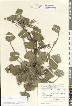
LE 01309239
Trapa colchica Albov ⟮s. l.⟯ det. Tzvelev, Nikolai Nikolaievich at 11.08.1965
Collectors: Tzvelev, Nikolai Nikolaievich; Kolesnikova, Tatiana Field collecting number: 265. Collection date: 11.08.1965. Administrative regions: RU - Astrakhanskaya Oblast' - Ikryaninskiy Rayon. Subregion: Икрянинский сельсовет. Топоним: система ериков реки Хурдун, Астраханская область. Place of collection: дельта реки Волга, в 2-3 километрах к северо-западу от поселка Икряное.Groups of specimens: Образцы сектора Восточной Европы; Ленинград. Ботанический институт Академии Наук СССР. Гербарий.; Гербарий Ботанического Института Академии наук СССР; Herbarium Instituti Botanici Academiae Sc. URSSLife form: hydrophyteOriginal label text:Астраханская область Дельта Волги. В ерике системы реки Хурдун километрах в 2-3 к северо=западу от поселка Икряное.
Landscape in location of collection: степиHabitat / plant community in location of collecting: в воде ерикаSubstrate in collecting location: siltCoordinates (geographic position): 46° 5′ 14.73″ N, 47° 41′ 6.55″ ERecord creation: 2025-06-03, Denis Melnikov, PhotoScan D2Citation: Specimen LE 01309239 // Virtual herbarium of Komarov Botanical Institute RAS — http://re.herbariumle.ru/01309239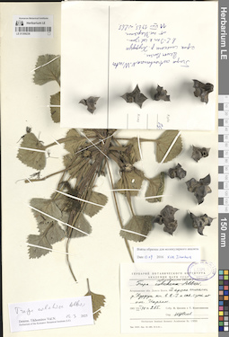
LE 01309238
Trapa astrachanica (Flerow) N.A. Winter det. Tzvelev, Nikolai Nikolaievich at 11.08.1965
Collectors: Tzvelev, Nikolai Nikolaievich; Kolesnikova, Tatiana Field collecting number: 265. Collection date: 11.08.1965. Administrative regions: RU - Astrakhanskaya Oblast' - Ikryaninskiy Rayon. Subregion: Икрянинский сельсовет. Топоним: система ериков реки Хурдун, Астраханская область. Place of collection: дельта реки Волга, в 2-3 километрах к северо-западу от поселка Икряное.Groups of specimens: Образцы сектора Восточной Европы; Гербарий Ботанического Института Академии наук СССР; Ex Herb. Inst. Bot. Ac. Sc. URSS Leningrad; Herbarium Instituti Botanici Academiae Sc. URSSLife form: hydrophyteOriginal label text:Астраханская область Дельта Волги. В ерике системы реки Хурдун километрах в 2-3 к северо=западу от поселка Икряное.
Landscape in location of collection: степиHabitat / plant community in location of collecting: в воде ерикаSubstrate in collecting location: siltCoordinates (geographic position): 46° 5′ 14.73″ N, 47° 41′ 6.55″ ERecord creation: 2025-06-03, Denis Melnikov, PhotoScan D2Citation: Specimen LE 01309238 // Virtual herbarium of Komarov Botanical Institute RAS — http://re.herbariumle.ru/01309238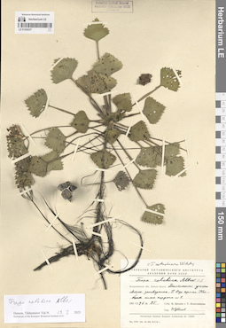
LE 01309237
Trapa colchica Albov ⟮s. l.⟯ det. Tzvelev, Nikolai Nikolaievich at 26.07.1965
Additional identifications: Trapa colchica Albov det. Tikhomirov, Valery Nikolaevich at 19.03.2025 Collectors: Tzvelev, Nikolai Nikolaievich; Kolesnikova, Tatiana Field collecting number: 95. Collection date: 26.07.1965. Administrative regions: RU - Astrakhanskaya Oblast' - Kamyzyakskiy Rayon. Subregion: Образцово-Травинский сельсовет. Топоним: ерик Колбин, Астраханская область. Place of collection: дельта реки Волга, Дамчикский участок Астраханского заповедника, ниже кордона №1.Groups of specimens: Образцы сектора Восточной Европы; Гербарий Ботанического Института Академии наук СССР; Herbarium Instituti Botanici Academiae Sc. URSS; Herbarium of the Komarov Botanical Institute (LE); Herbarium Instituti Botanici Academiae Scientiarum URSS. Leningrad.Life form: hydrophyteOriginal label text:Астраханская область Дельта Волги. Дамчикский участок Астраханского заповедника. В воде ерика Колбина ниже кордона №1.
Landscape in location of collection: степиHabitat / plant community in location of collecting: в воде ерикаSubstrate in collecting location: siltCoordinates (geographic position): 45° 50′ 17.97″ N, 47° 53′ 9.99″ ERecord creation: 2025-06-03, Denis Melnikov, PhotoScan D2Citation: Specimen LE 01309237 // Virtual herbarium of Komarov Botanical Institute RAS — http://re.herbariumle.ru/01309237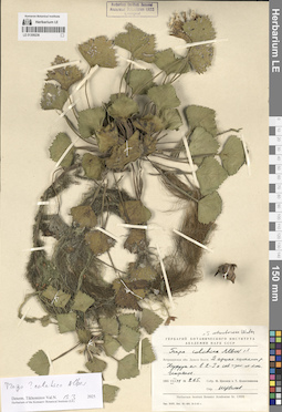
LE 01309236
Trapa colchica Albov ⟮s. l.⟯ det. Tzvelev, Nikolai Nikolaievich at 11.08.1965
Additional identifications: Trapa colchica Albov ⟮prelim. ID⟯ det. Tikhomirov, Valery Nikolaevich at 19.03.2025 Collectors: Tzvelev, Nikolai Nikolaievich; Kolesnikova, Tatiana Field collecting number: 265. Collection date: 11.08.1965. Administrative regions: RU - Astrakhanskaya Oblast' - Ikryaninskiy Rayon. Subregion: Икрянинский сельсовет. Топоним: система ериков реки Хурдун, Астраханская область. Place of collection: дельта реки Волга, в 2-3 километрах к северо-западу от поселка Икряное.Groups of specimens: Образцы сектора Восточной Европы; Гербарий Ботанического Института Академии наук СССР; Herbarium Instituti Botanici Academiae Sc. URSS; Herbarium of the Komarov Botanical Institute (LE); Herbarium Instituti Botanici Academiae Scientiarum URSS. Leningrad.Life form: hydrophyteOriginal label text:Астраханская область Дельта Волги. В ерике системы реки Хурдун километрах в 2-3 к северо=западу от поселка Икряное.
Landscape in location of collection: степиHabitat / plant community in location of collecting: в воде ерикаSubstrate in collecting location: siltCoordinates (geographic position): 46° 5′ 14.73″ N, 47° 41′ 6.55″ ERecord creation: 2025-06-03, Denis Melnikov, PhotoScan D2Citation: Specimen LE 01309236 // Virtual herbarium of Komarov Botanical Institute RAS — http://re.herbariumle.ru/01309236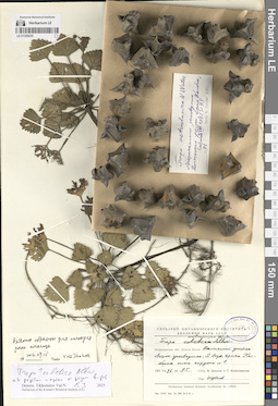
LE 01309235
Trapa astrachanica (Flerow) N.A. Winter det. Tzvelev, Nikolai Nikolaievich at 1991
Additional identifications: Trapa colchica Albov ⟮prelim. ID⟯ ⟨м. б. розетки и орехи от разных видов⟩ det. Tikhomirov, Valery Nikolaevich at 19.03.2025 Collectors: Tzvelev, Nikolai Nikolaievich; Kolesnikova, Tatiana Field collecting number: 95. Collection date: 26.07.1965. Administrative regions: RU - Astrakhanskaya Oblast' - Kamyzyakskiy Rayon. Subregion: Образцово-Травинский сельсовет. Топоним: ерик Колбин, Астраханская область. Place of collection: дельта реки Волга, Дамчикский участок Астраханского заповедника, ниже кордона №1.Groups of specimens: Образцы сектора Восточной Европы; Herb. Inst. Bot. Ac. Sc. URSS Leningrad; Гербарий Ботанического Института Академии наук СССР; Herbarium Instituti Botanici Academiae Sc. URSSLife form: hydrophyteOriginal label text:Астраханская область Дельта Волги. Дамчикский участок Астраханского заповедника. В воде ерика Колбина ниже кордона №1.
Landscape in location of collection: степиHabitat / plant community in location of collecting: в воде ерикаSubstrate in collecting location: siltCoordinates (geographic position): 45° 50′ 17.97″ N, 47° 53′ 9.99″ EComment: Взяты образцы для молекулярного анализа 2016.09.15 Xue Jianhua
Record creation: 2025-06-03, Denis Melnikov, PhotoScan D2Citation: Specimen LE 01309235 // Virtual herbarium of Komarov Botanical Institute RAS — http://re.herbariumle.ru/01309235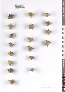
LE 01309234
Trapa sp.
Groups of specimens: Образцы сектора Восточной ЕвропыObject features: Плоды, выпавшие из гербарных образцов. Плоды пронумерованыRecord creation: 2025-06-03, Denis Melnikov, PhotoScan D2Citation: Specimen LE 01309234 // Virtual herbarium of Komarov Botanical Institute RAS — http://re.herbariumle.ru/01309234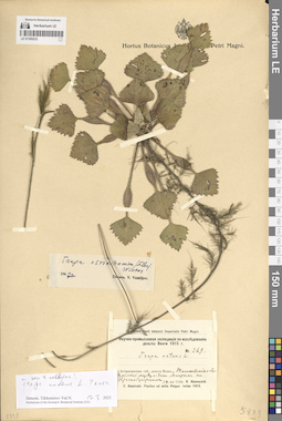
LE 01309233
Trapa natans L. det. Kosinskiy (Kossinski), Konstantin Konstantinovich at 19.06.1915
Additional identifications: Trapa astrachanica (Flerow) N.A. Winter det. Vassiljev, Viktor Nikolayevich at 1947; Trapa natans L. ⟮s. str.⟯ det. Tikhomirov, Valery Nikolaevich at 19.03.2025 Collectors: Kosinskiy (Kossinski), Konstantin Konstantinovich Field collecting number: 269. Collection date: 19.06.1915. Administrative regions: RU - Astrakhanskaya Oblast' - Volodarskiy Rayon. Subregion: Маковский сельсовет. Топоним: Тишковские острова, Астраханская область (Вшивые острова). Place of collection: ильмень между островами Мокрый и Краснобугорский.Expedition: Научно-промысловая экспедиция по исследованию дельты Волги (1914 -1915)Groups of specimens: Образцы сектора Восточной Европы; Herbarium Horti botanici Imperialis Petri Magni; C. Kossinski. Plantae ad ostia Volgae lectae 1915.; Herbarium of the Komarov Botanical Institute (LE)Life form: hydrophyteOriginal label text:Астраханская губерния, дельта Волги Тишковские острова: ильмень между островами Мокрым и Краснобугорским.
Landscape in location of collection: степиHabitat / plant community in location of collecting: прибрежная зона рекиSubstrate in collecting location: siltCoordinates (geographic position): 45° 56′ 41.53″ N, 48° 49′ 2.28″ ERecord creation: 2025-06-03, Denis Melnikov, PhotoScan D2Citation: Specimen LE 01309233 // Virtual herbarium of Komarov Botanical Institute RAS — http://re.herbariumle.ru/01309233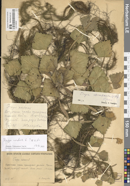
LE 01309232
Trapa natans L. det. Sakharova, N. at 08.07.1925
Additional identifications: Trapa astrachanica (Flerow) N.A. Winter det. Vassiljev, Viktor Nikolayevich at 1946; Trapa natans L. ⟮s. str.⟯ det. Tikhomirov, Valery Nikolaevich at 19.03.2025 Collectors: Sakharova, N. Collection date: 08.07.1925. Administrative regions: RU - Astrakhanskaya Oblast'; KZ - Atyrau Oblysy. Топоним: залив (культук) Прямой, дельта реки Волга. Place of collection: восточная часть приморской дельты реки Волга.Groups of specimens: Образцы сектора Восточной Европы; Museum Botanicum Academiae Scientiarum Petropolitanae; Herbarium of the Komarov Botanical Institute (LE)Life form: hydrophyteObject features: Длина растения = 3 метраOriginal label text:Восточная часть приморской дельты Волги. Залив (культук) прямой. Длина растения = 3 метра
Landscape in location of collection: степиHabitat / plant community in location of collecting: прибрежная зона рекиSubstrate in collecting location: siltRecord creation: 2025-06-03, Denis Melnikov, PhotoScan D2Citation: Specimen LE 01309232 // Virtual herbarium of Komarov Botanical Institute RAS — http://re.herbariumle.ru/01309232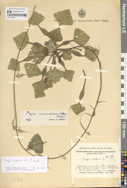
LE 01309231
Trapa natans L. det. Kosinskiy (Kossinski), Konstantin Konstantinovich at 19.06.1915
Additional identifications: Trapa astrachanica (Flerow) N.A. Winter det. Vassiljev, Viktor Nikolayevich at 1947; Trapa natans L. ⟮s. str.⟯ det. Tikhomirov, Valery Nikolaevich at 19.03.2025 Collectors: Kosinskiy (Kossinski), Konstantin Konstantinovich Field collecting number: 269. Collection date: 19.06.1915. Administrative regions: RU - Astrakhanskaya Oblast' - Volodarskiy Rayon. Subregion: Маковский сельсовет. Топоним: Тишковские острова, Астраханская область (Вшивые острова). Place of collection: ильмень между островами Мокрый и Краснобугорский.Expedition: Научно-промысловая экспедиция по исследованию дельты Волги (1914 -1915)Groups of specimens: Образцы сектора Восточной Европы; Hortus Botanicus Imperialis Petri Magni.; Herbarium Horti botanici Imperialis Petri Magni; C. Kossinski. Plantae ad ostia Volgae lectae 1915.Life form: hydrophyteOriginal label text:Астраханская губерния, дельта Волги Тишковские острова: ильмень между островами Мокрым и Краснобугорским
Landscape in location of collection: степиHabitat / plant community in location of collecting: прибрежная зона рекиSubstrate in collecting location: siltCoordinates (geographic position): 45° 56′ 41.53″ N, 48° 49′ 2.28″ ERecord creation: 2025-06-03, Denis Melnikov, PhotoScan D2Citation: Specimen LE 01309231 // Virtual herbarium of Komarov Botanical Institute RAS — http://re.herbariumle.ru/01309231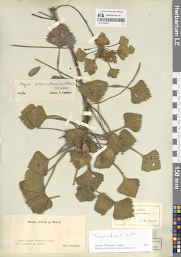
LE 01309230
Trapa caucasica auct. det. Flerow, Alexandr Fedorovich at 03.1914
Additional identifications: Trapa natans L. ⟮s. str.⟯ det. Tikhomirov, Valery Nikolaevich at 19.03.2025 Collectors: Korshinsky, Sergei Ivanovitsch Administrative regions: KZ - Atyrau Oblysy. Subregion: Курмангазинский район, Морской (Теңіз) сельский округ. Топоним: залив Синее Морцо, Казахстан. Place of collection: между заливом Синее Морцо и Кабаньим ильменем, взморье.Groups of specimens: Образцы сектора Восточной Европы; Herbarium Academiae Scientiarum Petropol.; Флора дельты реки Волги; Herbarium of the Komarov Botanical Institute (LE)Life form: hydrophyteOriginal label text:Между Синим Морцом и Кабаньим ильменем на взморьи.
Landscape in location of collection: степиHabitat / plant community in location of collecting: прибрежная зона рекиSubstrate in collecting location: siltCoordinates (geographic position): 46° 21′ 13.87″ N, 49° 23′ 46.96″ ERecord creation: 2025-06-03, Denis Melnikov, PhotoScan D2Citation: Specimen LE 01309230 // Virtual herbarium of Komarov Botanical Institute RAS — http://re.herbariumle.ru/01309230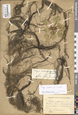
LE 01309229
Trapa natans L. det. Krymskaya, M. at 27.07.1936
Additional identifications: Trapa astrachanica (Flerow) N.A. Winter det. Vassiljev, Viktor Nikolayevich at 04.1959; Trapa natans L. ⟮s. str.⟯ det. Tikhomirov, Valery Nikolaevich at 19.03.2025 Collectors: Krymskaya, M. Collection date: 27.07.1936. Administrative regions: RU - Astrakhanskaya Oblast' - Volodarskiy Rayon. Subregion: Калининский сельсовет. Топоним: Обжоровская коса, Астраханская область. Place of collection: дельта реки Волга, Астраханский государственный заповедник.Groups of specimens: Образцы сектора Восточной Европы; Herbarium Universitatis saratoviensis; Herbarium of the Komarov Botanical Institute (LE)Life form: hydrophyteOriginal label text:Дельта Волги. Астраханский государственный заповедник. Обжоровская коса
Landscape in location of collection: степиHabitat / plant community in location of collecting: прибрежная зона рекиSubstrate in collecting location: siltCoordinates (geographic position): 46° 18′ 16.6″ N, 49° 1′ 51.92″ ERecord creation: 2025-06-03, Denis Melnikov, PhotoScan D2Citation: Specimen LE 01309229 // Virtual herbarium of Komarov Botanical Institute RAS — http://re.herbariumle.ru/01309229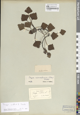
LE 01309228
Trapa natans L.
Additional identifications: Trapa natans L. ⟮prelim. ID⟯ det. Flerow, Alexandr Fedorovich at 03.03.1914; Trapa astrachanica (Flerow) N.A. Winter det. Vassiljev, Viktor Nikolayevich at 1947; Trapa natans L. ⟮s. str.⟯ det. Tikhomirov, Valery Nikolaevich at 19.03.2025 Administrative regions: RU - Astrakhanskaya Oblast' - Gorod Astrakhan'. Топоним: Astrachan (г. Астрахань). Place of collection: Астрахань.Groups of specimens: Образцы сектора Восточной Европы; Herbarium Academiae Scientiarum Petropol.; Herbarium of the Komarov Botanical Institute (LE)Life form: hydrophyteOriginal label text:Astrachan
Landscape in location of collection: степиHabitat / plant community in location of collecting: прибрежная зона рекиSubstrate in collecting location: siltCoordinates (geographic position): 46° 20′ 51.41″ N, 48° 1′ 48.64″ ERecord creation: 2025-06-03, Denis Melnikov, PhotoScan D2Citation: Specimen LE 01309228 // Virtual herbarium of Komarov Botanical Institute RAS — http://re.herbariumle.ru/01309228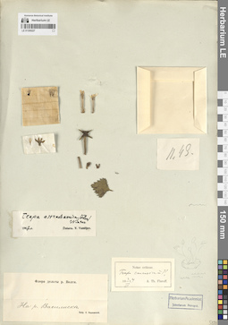
LE 01309227
Trapa caucasica auct. det. Flerow, Alexandr Fedorovich at 03.03.1914
Additional identifications: Trapa astrachanica (Flerow) N.A. Winter det. Vassiljev, Viktor Nikolayevich at 1947 Collectors: Korshinsky, Sergei Ivanovitsch Administrative regions: RU - Astrakhanskaya Oblast' - Volodarskiy Rayon. Subregion: Мултановский сельсовет. Топоним: река Василиска (река Васильевская, Астраханская область). Place of collection: дельта реки Волга, река Васильевская.Groups of specimens: Образцы сектора Восточной Европы; Herbarium Academiae Scientiarum Petropol.; Флора дельты реки ВолгиLife form: hydrophyteOriginal label text:На реке Василиске.
Landscape in location of collection: степиHabitat / plant community in location of collecting: прибрежная зона рекиSubstrate in collecting location: siltCoordinates (geographic position): 46° 16′ 7.26″ N, 48° 49′ 35.2″ ERecord creation: 2025-06-03, Denis Melnikov, PhotoScan D2Citation: Specimen LE 01309227 // Virtual herbarium of Komarov Botanical Institute RAS — http://re.herbariumle.ru/01309227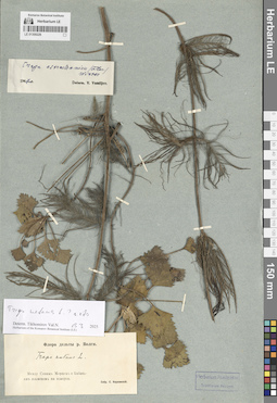
LE 01309226
Trapa natans L. det. Korshinsky, Sergei Ivanovitsch
Additional identifications: Trapa astrachanica (Flerow) N.A. Winter det. Vassiljev, Viktor Nikolayevich at 1947; Trapa natans L. ⟮s. str.⟯ det. Tikhomirov, Valery Nikolaevich at 19.03.2025 Collectors: Korshinsky, Sergei Ivanovitsch Administrative regions: KZ - Atyrau Oblysy. Subregion: Курмангазинский район, Морской (Теңіз) сельский округ. Топоним: залив Синее Морцо, Казахстан. Place of collection: между заливом Синее Морцо и Кабаньим ильменем, взморье.Groups of specimens: Образцы сектора Восточной Европы; Herbarium Academiae Scientiarum Petropol.; Флора дельты реки Волги; Herbarium of the Komarov Botanical Institute (LE)Life form: hydrophyteOriginal label text:Между Синим Морцом и Кабаньим ильменем на взморьи.
Landscape in location of collection: степиHabitat / plant community in location of collecting: прибрежная зона заливаSubstrate in collecting location: siltCoordinates (geographic position): 46° 21′ 13.87″ N, 49° 23′ 46.96″ ERecord creation: 2025-06-03, Denis Melnikov, PhotoScan D2Citation: Specimen LE 01309226 // Virtual herbarium of Komarov Botanical Institute RAS — http://re.herbariumle.ru/01309226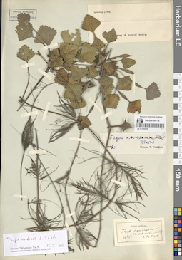
LE 01309225
Trapa caucasica auct. det. Flerow, Alexandr Fedorovich at 02.03.1914
Additional identifications: Trapa astrachanica (Flerow) N.A. Winter det. Vassiljev, Viktor Nikolayevich at 1947; Trapa natans L. ⟮s. str.⟯ det. Tikhomirov, Valery Nikolaevich at 19.03.2025 Collectors: Korshinsky, Sergei Ivanovitsch Administrative regions: RU - Astrakhanskaya Oblast'; KZ - Atyrau Oblysy. Place of collection: дельта реки Волга.Groups of specimens: Образцы сектора Восточной Европы; Herbarium Academiae Scientiarum Petropol.; Флора дельты реки Волги; Herbarium of the Komarov Botanical Institute (LE)Life form: hydrophyteLandscape in location of collection: степиHabitat / plant community in location of collecting: прибрежная зона водоемаSubstrate in collecting location: siltRecord creation: 2025-06-03, Denis Melnikov, PhotoScan D2Citation: Specimen LE 01309225 // Virtual herbarium of Komarov Botanical Institute RAS — http://re.herbariumle.ru/01309225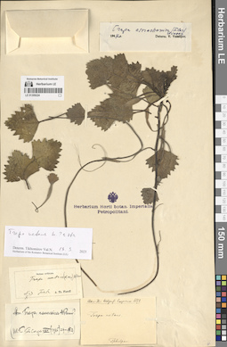
LE 01309224
Trapa natans L. det. Claus, Karl Ernst at 1852
Additional identifications: Trapa natans L. det. Flerow, Alexandr Fedorovich at 05.10.1913; Trapa caucasica auct.; Trapa natans L. ⟮s. str.⟯ det. Tikhomirov, Valery Nikolaevich at 19.03.2025 Collectors: Claus, Karl Ernst Collection date: 1852. Administrative regions: RU - Astrakhanskaya Oblast' - Ikryaninskiy Rayon. Subregion: Чулпанский сельсовет. Топоним: деревня Чулпан, Астраханская область (село Чулпан, с тат. яз. - Венера). Place of collection: село Чулпан.Expedition: Claus. Iter Wolgensi Caspicum. 1852 ()Groups of specimens: Образцы сектора Восточной Европы; Herbarium of the Komarov Botanical Institute (LE)Life form: hydrophyteOriginal label text:Tschulpan.
Landscape in location of collection: степиHabitat / plant community in location of collecting: прибрежная зона рекиSubstrate in collecting location: siltCoordinates (geographic position): 45° 53′ 34.42″ N, 47° 42′ 39.79″ ERecord creation: 2025-06-03, Denis Melnikov, PhotoScan D2Citation: Specimen LE 01309224 // Virtual herbarium of Komarov Botanical Institute RAS — http://re.herbariumle.ru/01309224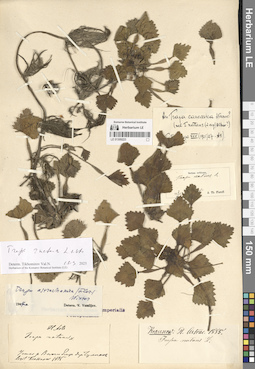
LE 01309223
Trapa natans L. det. Krasnov (Krassnov), Andrej Nikovaevich at 1885
Additional identifications: Trapa astrachanica (Flerow) N.A. Winter det. Vassiljev, Viktor Nikolayevich at 1947; Trapa natans L. ⟮s. str.⟯ det. Tikhomirov, Valery Nikolaevich at 19.03.2025 Collectors: Krasnov (Krassnov), Andrej Nikovaevich Collection date: 1885. Administrative regions: RU - Astrakhanskaya Oblast' - Ikryaninskiy Rayon. Subregion: Чулпанский сельсовет. Топоним: деревня Чулпан, Астраханская область (село Чулпан, с тат. яз. - Венера). Place of collection: устье реки Волга, близ села Чулпан.Groups of specimens: Образцы сектора Восточной Европы; Herbarium Horti botan. Imperialis Petropolitani; Herbarium of the Komarov Botanical Institute (LE)Life form: hydrophyteOriginal label text:Устье реки Волги близ деревни Чулпан
Landscape in location of collection: степиHabitat / plant community in location of collecting: прибрежная зона рекиSubstrate in collecting location: siltCoordinates (geographic position): 45° 53′ 34.42″ N, 47° 42′ 39.79″ ERecord creation: 2025-06-03, Denis Melnikov, PhotoScan D2Citation: Specimen LE 01309223 // Virtual herbarium of Komarov Botanical Institute RAS — http://re.herbariumle.ru/01309223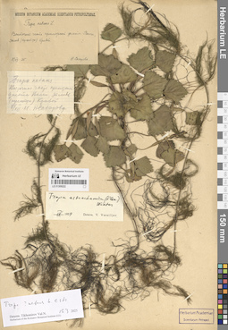
LE 01309222
Trapa natans L. det. Sakharova, N. at 08.07.1925
Additional identifications: Trapa astrachanica (Flerow) N.A. Winter det. Vassiljev, Viktor Nikolayevich at 04.1959; Trapa natans L. ⟮s. str.⟯ det. Tikhomirov, Valery Nikolaevich at 19.03.2025 Collectors: Sakharova, N. Collection date: 08.07.1925. Administrative regions: RU - Astrakhanskaya Oblast'; KZ - Atyrau Oblysy. Топоним: залив (культук) Кривой, дельта реки Волга. Place of collection: восточная часть приморской дельты реки Волга.Groups of specimens: Образцы сектора Восточной Европы; Herbarium Academiae Scientiarum Petropol.; Museum Botanicum Academiae Scientiarum Petropolitanae; Herbarium of the Komarov Botanical Institute (LE)Life form: hydrophyteOriginal label text:Восточная часть приморской дельты Волги, залив (культук) Кривой.
Landscape in location of collection: степиHabitat / plant community in location of collecting: прибрежная зона заливаSubstrate in collecting location: siltRecord creation: 2025-06-03, Denis Melnikov, PhotoScan D2Citation: Specimen LE 01309222 // Virtual herbarium of Komarov Botanical Institute RAS — http://re.herbariumle.ru/01309222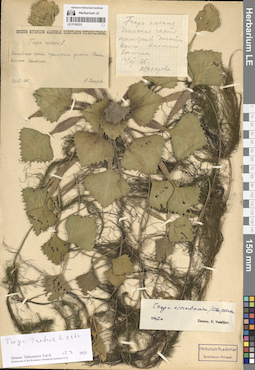
LE 01309221
Trapa natans L. det. Sakharova, N. at 17.07.1925
Additional identifications: Trapa astrachanica (Flerow) N.A. Winter det. Vassiljev, Viktor Nikolayevich at 1947; Trapa natans L. ⟮s. str.⟯ det. Tikhomirov, Valery Nikolaevich at 19.03.2025 Collectors: Sakharova, N. Collection date: 17.07.1925. Administrative regions: RU - Astrakhanskaya Oblast' - Kamyzyakskiy Rayon. Subregion: Образцово-Травинский сельсовет. Топоним: ильмень Дамчик, Астраханская область. Place of collection: западная часть приморской дельты реки Волга.Groups of specimens: Образцы сектора Восточной Европы; Herbarium Academiae Scientiarum Petropol.; Museum Botanicum Academiae Scientiarum PetropolitanaeLife form: hydrophyteOriginal label text:Западная часть приморской дельты Волги. Ильмень Дамчик.
Landscape in location of collection: степиHabitat / plant community in location of collecting: прибрежная зона ильменяSubstrate in collecting location: siltCoordinates (geographic position): 45° 47′ 27.38″ N, 47° 53′ 37.56″ ERecord creation: 2025-06-03, Denis Melnikov, PhotoScan D2Citation: Specimen LE 01309221 // Virtual herbarium of Komarov Botanical Institute RAS — http://re.herbariumle.ru/01309221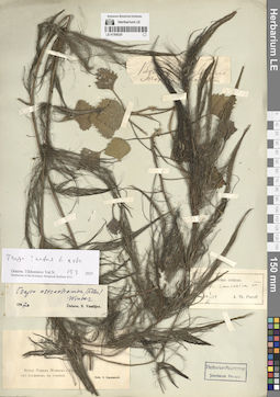
LE 01309220
Additional identifications: Trapa caucasica auct. det. Flerow, Alexandr Fedorovich at 03.03.1914; Trapa astrachanica (Flerow) N.A. Winter det. Vassiljev, Viktor Nikolayevich at 1947; Trapa natans L. ⟮s. str.⟯ det. Tikhomirov, Valery Nikolaevich at 19.03.2025 Collectors: Korshinsky, Sergei Ivanovitsch Administrative regions: KZ - Atyrau Oblysy. Subregion: Курмангазинский район, Морской (Теңіз) сельский округ. Топоним: залив Синее Морцо, Казахстан. Place of collection: между заливом Синее Морцо и Кабаньим ильменем, взморье.Groups of specimens: Образцы сектора Восточной Европы; Herbarium Academiae Scientiarum Petropol.; Флора дельты реки Волги; Herbarium of the Komarov Botanical Institute (LE)Life form: hydrophyteOriginal label text:
Между Синим Морцом и Кабаньим ильменем на взморьи.
Landscape in location of collection: степиHabitat / plant community in location of collecting: прибрежная зона заливаSubstrate in collecting location: siltCoordinates (geographic position): 46° 21′ 13.87″ N, 49° 23′ 46.96″ ERecord creation: 2025-06-03, Denis Melnikov, PhotoScan D2Citation: Specimen LE 01309220 // Virtual herbarium of Komarov Botanical Institute RAS — http://re.herbariumle.ru/01309220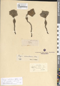
LE 01309219
Trapa colchica Albov det. Flerow, Alexandr Fedorovich at 06.10.1913
Additional identifications: Trapa astrachanica (Flerow) N.A. Winter det. Vassiljev, Viktor Nikolayevich at 1947; Trapa colchica Albov det. Tikhomirov, Valery Nikolaevich at 19.03.2025; Trapa maeotica Woronow det. Tikhomirov, Valery Nikolaevich at 19.03.2025 Collectors: Pallas, Peter (Pyotr) Simon von Administrative regions: RU - Russian Federation. Groups of specimens: Образцы сектора Восточной Европы; Herbarium Horti botan. Imperialis Petropolitani; Herb. FischerLife form: hydrophyteHabitat / plant community in location of collecting: прибрежная зона водоемаSubstrate in collecting location: siltRecord creation: 2025-06-03, Denis Melnikov, PhotoScan D2Citation: Specimen LE 01309219 // Virtual herbarium of Komarov Botanical Institute RAS — http://re.herbariumle.ru/01309219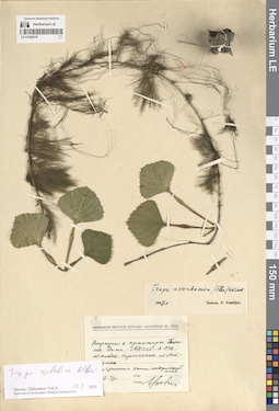
LE 01309218
Trapa astrachanica (Flerow) N.A. Winter det. Vassiljev, Viktor Nikolayevich at 1947
Additional identifications: Trapa colchica Albov det. Tikhomirov, Valery Nikolaevich at 19.03.2025 Collection date: 11.10.1947. Administrative regions: RU - Astrakhanskaya Oblast' - Gorod Astrakhan'. Топоним: Astrachan (г. Астрахань). Place of collection: Астрахань.Groups of specimens: Образцы сектора Восточной Европы; Herbarium Instituti Botanici Academiae Sc. URSS; Herbarium of the Komarov Botanical Institute (LE)Life form: hydrophyteObject features: с растением материнский плодOriginal label text:Выращено в оранжерее Ботанического Института АН СССР в 1947 из плодов, присланных из Астрахани.
Landscape in location of collection: степи (материнский плод)Habitat / plant community in location of collecting: прибрежная зона реки (материнский плод)Substrate in collecting location: siltCoordinates (geographic position): 46° 20′ 54.04″ N, 48° 1′ 42.7″ ERecord creation: 2025-06-03, Denis Melnikov, PhotoScan D2Citation: Specimen LE 01309218 // Virtual herbarium of Komarov Botanical Institute RAS — http://re.herbariumle.ru/01309218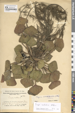
LE 01309217
Trapa natans L. det. Kosinskiy (Kossinski), Konstantin Konstantinovich at 18.08.1915
Additional identifications: Trapa astrachanica (Flerow) N.A. Winter det. Vassiljev, Viktor Nikolayevich at 1946; Trapa colchica Albov det. Tikhomirov, Valery Nikolaevich at 19.03.2025 Collectors: Kosinskiy (Kossinski), Konstantin Konstantinovich Field collecting number: 984. Collection date: 18.08.1915. Administrative regions: RU - Astrakhanskaya Oblast' - Kamyzyakskiy Rayon. Subregion: Образцово-Травинский сельсовет. Топоним: ильмень Дамчик, Астраханская область. Place of collection: дельта реки Волга.Expedition: Научно-промысловая экспедиция по исследованию дельты Волги (1914 -1915)Groups of specimens: Образцы сектора Восточной Европы; Herbarium Horti botanici Imperialis Petri Magni; C. Kossinski. Plantae ad ostia Volgae lectae 1915.; Herbarium of the Komarov Botanical Institute (LE)Life form: hydrophyteOriginal label text:Астраханская губерния, дельта Волги, ильмень Дамчик, на одном из островков, в западине с водой.
Landscape in location of collection: степиHabitat / plant community in location of collecting: на одном из островков ильменя, в западине с водойSubstrate in collecting location: siltCoordinates (geographic position): 45° 47′ 43.94″ N, 47° 53′ 47.29″ ERecord creation: 2025-06-03, Denis Melnikov, PhotoScan D2Citation: Specimen LE 01309217 // Virtual herbarium of Komarov Botanical Institute RAS — http://re.herbariumle.ru/01309217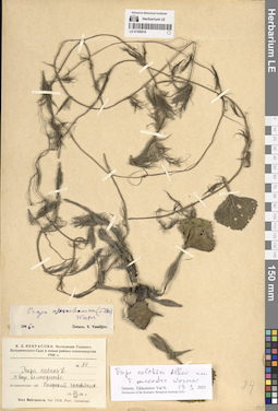
LE 01309216
Trapa natans L. det. Nekrasova, Vera Leontievna at 23.08.1928
Additional identifications: Trapa astrachanica (Flerow) N.A. Winter det. Vassiljev, Viktor Nikolayevich at 1946; Trapa colchica Albov det. Tikhomirov, Valery Nikolaevich at 19.03.2025; Trapa maeotica Woronow det. Tikhomirov, Valery Nikolaevich at 19.03.2025 Collectors: Nekrasova, Vera Leontievna Field collecting number: 84. Collection date: 23.08.1928. Administrative regions: RU - Astrakhanskaya Oblast' - Kamyzyakskiy Rayon. Subregion: Образцово-Травинский сельсовет. Топоним: Волжский заповедник (Астраханский биосферный заповедник). Place of collection: дельта реки Волга.Expedition: В. Л. Некрасова: Экспедиция Главного Ботанического Сада в новые районы хлопководства 1928 г. ()Groups of specimens: Образцы сектора Восточной Европы; Herbarium of the Komarov Botanical Institute (LE)Life form: hydrophyteObject features: в воде, во множествеOriginal label text:Астраханская губерния Волжский заповедник
Landscape in location of collection: степиHabitat / plant community in location of collecting: прибрежная зона рекиSubstrate in collecting location: siltCoordinates (geographic position): 45° 47′ 44.74″ N, 47° 53′ 31.4″ ERecord creation: 2025-06-03, Denis Melnikov, PhotoScan D2Citation: Specimen LE 01309216 // Virtual herbarium of Komarov Botanical Institute RAS — http://re.herbariumle.ru/01309216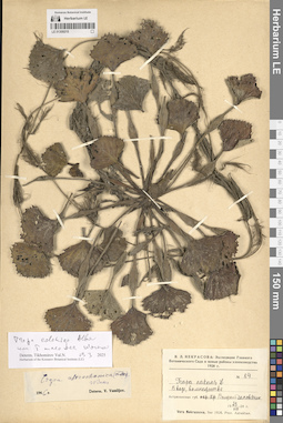
LE 01309215
Trapa natans L. det. Nekrasova, Vera Leontievna at 23.08.1928
Additional identifications: Trapa astrachanica (Flerow) N.A. Winter det. Vassiljev, Viktor Nikolayevich at 1946; Trapa colchica Albov det. Tikhomirov, Valery Nikolaevich at 19.03.2025; Trapa maeotica Woronow det. Tikhomirov, Valery Nikolaevich at 19.03.2025 Collectors: Nekrasova, Vera Leontievna Field collecting number: 84. Collection date: 23.08.1928. Administrative regions: RU - Astrakhanskaya Oblast' - Kamyzyakskiy Rayon. Subregion: Образцово-Травинский сельсовет. Топоним: Волжский заповедник (Астраханский биосферный заповедник). Place of collection: дельта реки Волга.Expedition: В. Л. Некрасова: Экспедиция Главного Ботанического Сада в новые районы хлопководства 1928 г. ()Groups of specimens: Образцы сектора Восточной Европы; Herbarium of the Komarov Botanical Institute (LE)Life form: hydrophyteObject features: в воде, во множествеOriginal label text:Астраханская губерния Волжский заповедник
Landscape in location of collection: степиHabitat / plant community in location of collecting: прибрежная зона рекиSubstrate in collecting location: siltCoordinates (geographic position): 45° 47′ 44.74″ N, 47° 53′ 31.4″ ERecord creation: 2025-06-03, Denis Melnikov, PhotoScan D2Citation: Specimen LE 01309215 // Virtual herbarium of Komarov Botanical Institute RAS — http://re.herbariumle.ru/01309215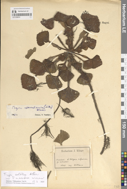
LE 01309214
Trapa colchica Albov det. Tikhomirov, Valery Nikolaevich at 19.03.2025
Additional identifications: Trapa maeotica Woronow det. Tikhomirov, Valery Nikolaevich at 19.03.2025 Collectors: Claus, Karl Ernst Collection date: 1848. Administrative regions: RU - Astrakhanskaya Oblast' - Gorod Astrakhan'. Топоним: Astrachan (г. Астрахань). Place of collection: низовья реки Волга, возле Астрахани.Groups of specimens: Образцы сектора Восточной Европы; Herbarium J. Klinge; Herbarium of the Komarov Botanical Institute (LE)Life form: hydrophyteOriginal label text:Fundort: ad Wolgam inferiorem prope Astrachan
Landscape in location of collection: степиHabitat / plant community in location of collecting: прибрежная зона рекиSubstrate in collecting location: siltCoordinates (geographic position): 46° 20′ 51.41″ N, 48° 1′ 48.64″ ERecord creation: 2025-06-03, Denis Melnikov, PhotoScan D2Citation: Specimen LE 01309214 // Virtual herbarium of Komarov Botanical Institute RAS — http://re.herbariumle.ru/01309214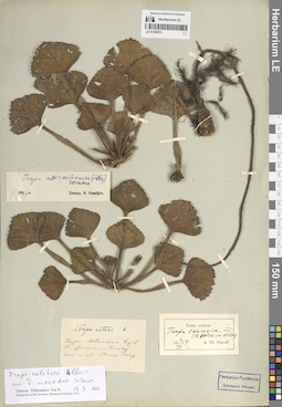
LE 01309213
Trapa natans L. det. illegible at 1849
Additional identifications: Trapa caucasica auct. det. Flerow, Alexandr Fedorovich at 02.03.1914; Trapa colchica Albov det. Tikhomirov, Valery Nikolaevich at 19.03.2025; Trapa maeotica Woronow det. Tikhomirov, Valery Nikolaevich at 19.03.2025 Collectors: illegible Field collecting number: 4. Collection date: 1849. Administrative regions: RU - Astrakhanskaya Oblast' - Gorod Astrakhan'. Топоним: Astrachan (г. Астрахань). Place of collection: возле Астрахани.Groups of specimens: Образцы сектора Восточной Европы; Herbarium Academiae Scientiarum Petropol.; Herbarium of the Komarov Botanical Institute (LE)Life form: hydrophyteOriginal label text:Prope Astrachan
Landscape in location of collection: степиHabitat / plant community in location of collecting: прибрежная зона рекиSubstrate in collecting location: siltCoordinates (geographic position): 46° 20′ 51.41″ N, 48° 1′ 48.64″ ERecord creation: 2025-06-03, Denis Melnikov, PhotoScan D2Citation: Specimen LE 01309213 // Virtual herbarium of Komarov Botanical Institute RAS — http://re.herbariumle.ru/01309213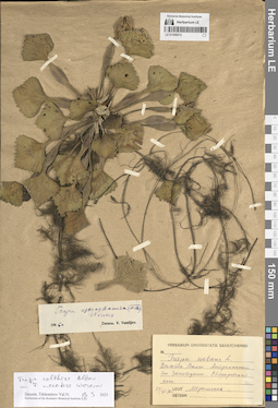
LE 01309212
Trapa natans L. det. Krymskaya, M. at 24.07.1936
Additional identifications: Trapa astrachanica (Flerow) N.A. Winter det. Vassiljev, Viktor Nikolayevich at 1946; Trapa colchica Albov det. Tikhomirov, Valery Nikolaevich at 19.03.2025; Trapa maeotica Woronow det. Tikhomirov, Valery Nikolaevich at 19.03.2025 Collectors: Krymskaya, M. Collection date: 24.07.1936. Administrative regions: RU - Astrakhanskaya Oblast' - Volodarskiy Rayon. Subregion: Калининский сельсовет. Топоним: Обжоровская коса, Астраханская область. Place of collection: дельта реки Волга, Астраханский государственный заповедник.Groups of specimens: Образцы сектора Восточной Европы; Herbarium Universitatis saratoviensis; Herbarium of the Komarov Botanical Institute (LE)Life form: hydrophyteOriginal label text:Дельта Волги. Астраханский государственный заповедник. Обжоровская коса
Landscape in location of collection: степиHabitat / plant community in location of collecting: прибрежная зона рекиSubstrate in collecting location: siltCoordinates (geographic position): 46° 18′ 16.6″ N, 49° 1′ 51.92″ ERecord creation: 2025-06-03, Denis Melnikov, PhotoScan D2Citation: Specimen LE 01309212 // Virtual herbarium of Komarov Botanical Institute RAS — http://re.herbariumle.ru/01309212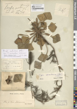
LE 01309211
Trapa caucasica auct. det. Flerow, Alexandr Fedorovich at 03.03.1914
Additional identifications: Trapa astrachanica (Flerow) N.A. Winter det. Vassiljev, Viktor Nikolayevich at 1946; Trapa colchica Albov det. Tikhomirov, Valery Nikolaevich at 19.03.2025 Collectors: Korshinsky, Sergei Ivanovitsch Administrative regions: RU - Astrakhanskaya Oblast' - Narimanovskiy Rayon. Subregion: Старокучергановский сельсовет. Топоним: река Большая Яблонка, Астраханская область (река Яблонька). Place of collection: дельта реки Волга.Groups of specimens: Образцы сектора Восточной Европы; Herbarium Academiae Scientiarum Petropol.; Флора дельты реки Волги; Herbarium of the Komarov Botanical Institute (LE)Life form: hydrophyteOriginal label text:На реке Большой Яблонке.
Landscape in location of collection: степиHabitat / plant community in location of collecting: прибрежная зона рекиSubstrate in collecting location: siltCoordinates (geographic position): 46° 15′ 51.83″ N, 47° 51′ 57.22″ ERecord creation: 2025-06-03, Denis Melnikov, PhotoScan D2Citation: Specimen LE 01309211 // Virtual herbarium of Komarov Botanical Institute RAS — http://re.herbariumle.ru/01309211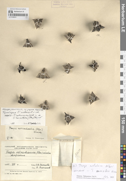
LE 01309210
Trapa astrachanica (Flerow) N.A. Winter det. Vassiljev, Viktor Nikolayevich at 08.1964
Additional identifications: Trapa astrachanica (Flerow) N.A. Winter det. Vassiljev, Viktor Nikolayevich at 05.1971; Trapa colchica Albov det. Tikhomirov, Valery Nikolaevich at 19.03.2025; Trapa maeotica Woronow det. Tikhomirov, Valery Nikolaevich at 19.03.2025 Collectors: Valjtsova, O. V. Collection date: 08.1964. Administrative regions: RU - Astrakhanskaya Oblast' - Gorod Astrakhan'. Топоним: Astrachan (г. Астрахань). Place of collection: Астрахань.Groups of specimens: Образцы сектора Восточной Европы; Гербарий Ботанического Института Академии наук СССР; Herbarium Instituti Botanici Academiae Sc. URSS; Herbarium of the Komarov Botanical Institute (LE)Life form: hydrophyteOriginal label text:Астрахань
Landscape in location of collection: степиHabitat / plant community in location of collecting: прибрежная зона рекиSubstrate in collecting location: siltRecord creation: 2025-06-03, Denis Melnikov, PhotoScan D2Citation: Specimen LE 01309210 // Virtual herbarium of Komarov Botanical Institute RAS — http://re.herbariumle.ru/01309210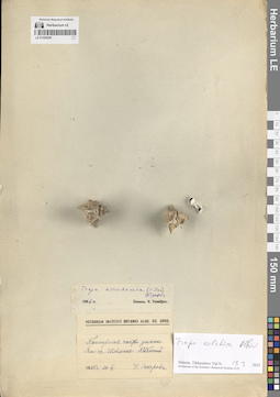
LE 01309209
Trapa astrachanica (Flerow) N.A. Winter det. Vassiljev, Viktor Nikolayevich at 1946
Additional identifications: Trapa colchica Albov det. Tikhomirov, Valery Nikolaevich at 19.03.2025 Collectors: Sakharova, N. Collection date: 30.09.1925. Administrative regions: RU - Astrakhanskaya Oblast' - Kamyzyakskiy Rayon. Subregion: Караулинский сельсовет. Топоним: остров (ильмень) Кабаний, Астраханская область. Place of collection: приморская часть дельты реки Волга.Groups of specimens: Образцы сектора Восточной Европы; Herbarium Instituti Botanici Acad. Sc. URSS; Herbarium of the Komarov Botanical Institute (LE)Life form: hydrophyteOriginal label text:Приморская часть дельты Волги. Ильмень Кабаний
Landscape in location of collection: степиHabitat / plant community in location of collecting: прибрежная зона рекиSubstrate in collecting location: siltCoordinates (geographic position): 45° 51′ 19″ N, 48° 13′ 32.32″ ERecord creation: 2025-06-03, Denis Melnikov, PhotoScan D2Citation: Specimen LE 01309209 // Virtual herbarium of Komarov Botanical Institute RAS — http://re.herbariumle.ru/01309209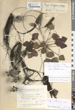
LE 01309208
Trapa alatyrica Sprygin ex V.N. Vassil. det. Czkalov, Andrey Vjacheslavovich at 2024
Additional identifications: Trapa borysthenica V.N. Vassil. det. Czkalov, Andrey Vjacheslavovich at 2024; Trapa natans L. ⟮s. str.⟯ det. Tikhomirov, Valery Nikolaevich at 19.03.2025 Collectors: Kucherova, E. Collection date: 21.08.1955. Administrative regions: RU - Bashkortostan - Buzdyakskiy Rayon. Subregion: Канлы-Туркеевский сельсовет. Топоним: озеро Улканлы-Куль (озеро Канлы-Куль). Place of collection: озеро Канлы-Куль.Groups of specimens: Образцы сектора Восточной Европы; Гербарий Ботанического Института Академии наук СССР; Herbarium Instituti Botanici Academiae Sc. URSS; Herbarium of the Komarov Botanical Institute (LE)Life form: hydrophyteOriginal label text:Башкирская АССР Нуримановский район, озеро Улканлы-куль.
Landscape in location of collection: лесостепиHabitat / plant community in location of collecting: прибрежная зона озераSubstrate in collecting location: siltCoordinates (geographic position): 54° 23′ 58.97″ N, 54° 24′ 37.67″ EComment: Взяты образцы для молекулярного анализа. 15.09.2016 / Xue Jianhua
Record creation: 2025-06-03, Denis Melnikov, PhotoScan D2Citation: Specimen LE 01309208 // Virtual herbarium of Komarov Botanical Institute RAS — http://re.herbariumle.ru/01309208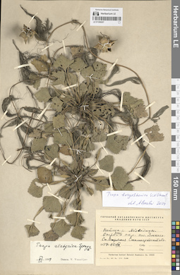
LE 01309207
Trapa alatyrica Sprygin ex V.N. Vassil. det. Vassiljev, Viktor Nikolayevich at 06.1959
Additional identifications: Trapa borysthenica V.N. Vassil. det. Czkalov, Andrey Vjacheslavovich at 2024 Collection date: 22.08.1957. Administrative regions: RU - Volgogradskaya Oblast' - Danilovskiy Rayon. Subregion: Островское сельское поселение. Топоним: озеро Ямное, Волгоградская область. Place of collection: пойма реки Медведица, в окрестностях станицы Островская.Groups of specimens: Образцы сектора Восточной Европы; Гербарий Ботанического Института Академии наук СССР; Herbarium Instituti Botanici Academiae Sc. URSSLife form: hydrophyteOriginal label text:Пойма реки Медведицы. Озеро Ямное в окрестностях поселка Ямного Станица Островская Сталинградской области
Landscape in location of collection: степиHabitat / plant community in location of collecting: прибрежная зона озераSubstrate in collecting location: siltCoordinates (geographic position): 50° 26′ 56.89″ N, 44° 24′ 7.54″ ERecord creation: 2025-06-03, Denis Melnikov, PhotoScan D2Citation: Specimen LE 01309207 // Virtual herbarium of Komarov Botanical Institute RAS — http://re.herbariumle.ru/01309207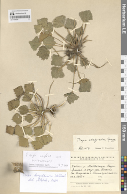
LE 01309206
Trapa alatyrica Sprygin ex V.N. Vassil. det. Vassiljev, Viktor Nikolayevich at 08.1959
Additional identifications: Trapa borysthenica V.N. Vassil. det. Czkalov, Andrey Vjacheslavovich at 2024; Trapa natans L. ⟮s. l.⟯ det. Tikhomirov, Valery Nikolaevich at 19.03.2025 Collection date: 22.08.1957. Administrative regions: RU - Volgogradskaya Oblast' - Danilovskiy Rayon. Subregion: Островское сельское поселение. Топоним: озеро Ямное, Волгоградская область. Place of collection: пойма реки Медведица, в окрестностях станицы Островская.Groups of specimens: Образцы сектора Восточной Европы; Гербарий Ботанического Института Академии наук СССР; Herbarium Instituti Botanici Academiae Sc. URSS; Herbarium of the Komarov Botanical Institute (LE)Life form: hydrophyteOriginal label text:Пойма реки Медведицы. Озеро Ямное в окрестностях поселка Ямного Станица Островская Сталинградской области
Landscape in location of collection: степиHabitat / plant community in location of collecting: прибрежная зона озераSubstrate in collecting location: siltCoordinates (geographic position): 50° 26′ 56.89″ N, 44° 24′ 7.54″ ERecord creation: 2025-06-03, Denis Melnikov, PhotoScan D2Citation: Specimen LE 01309206 // Virtual herbarium of Komarov Botanical Institute RAS — http://re.herbariumle.ru/01309206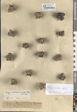
LE 01309205
Trapa astrachanica (Flerow) N.A. Winter
Additional identifications: Trapa astrachanica (Flerow) N.A. Winter det. Vassiljev, Viktor Nikolayevich at 09.1958; Trapa colchica Albov det. Tikhomirov, Valery Nikolaevich at 19.03.2025 Administrative regions: RU - Astrakhanskaya Oblast' - Volodarskiy Rayon. Subregion: Калининский сельсовет. Топоним: култук Гранушин, Астраханская область (ильмень култук Григорша). Place of collection: дельта реки Волга.Groups of specimens: Образцы сектора Восточной Европы; Herbarium of the Komarov Botanical Institute (LE)Life form: hydrophyteObject features: комплексOriginal label text:Из култука Гранушина в дельте Волги (45°50' северной широты и 47°53' восточной долготы)
Landscape in location of collection: степиHabitat / plant community in location of collecting: прибрежная зона рекиSubstrate in collecting location: siltCoordinates (geographic position): 46° 24′ 35.1″ N, 48° 59′ 8.45″ ERecord creation: 2025-06-03, Denis Melnikov, PhotoScan D2Citation: Specimen LE 01309205 // Virtual herbarium of Komarov Botanical Institute RAS — http://re.herbariumle.ru/01309205