View
Add
Copy
Edit
Delete
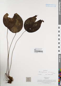
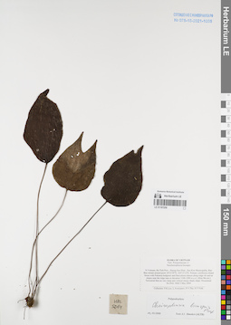
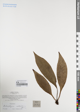
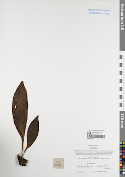
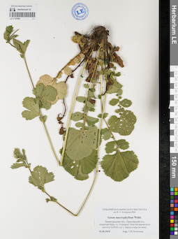
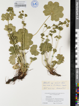
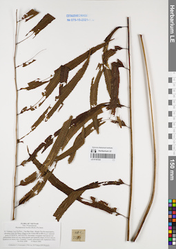
LE 01167262
Cheiropleuria bicuspis (Blume) C.Presl det. Shmakov, Aleksandr Ivanovich at 02.01.2008
Collectors: Averyanov, Leonid Vladimirovich; Phan Ke Loc; et al. Field collecting number: HLF7087. Collection date: 25.03.2007. Administrative regions: VN - Tinh Nghe An. Groups of specimens: L. V. Averyanov specimens; L. V. Averyanov herbarium; Соглашение Минобрнауки №075-15-2021-1056Original label text:FLORA OF VIETNAM
Polypodiaceae s.l.
Aneupleura bicuspis
Vietnam, Nghe An Prov., Tuong Duong Distr., Tam Hop Municipality, Pa Lom village, around point 19°05′07″N 104°20′55″E at elevation 1450-1550 m a.s.l. Submontane primary evergreen closed forest on very steep mountain slopes composed with stratified solid shale. Terrestrial fern on very steep slopes along tops of ridge and on very steep rocky shady mountain slopes. Not common. HLF 7087 25 March 2007.
Coll. Averyanov L., P.K.Loc, N.V.Trai, N.T.Vinh, N.D.Phuong, Averyanova A.
Grant from Henry Luce Foundation.
Coordinates (geographic position): 19° 5′ 7″ N, 104° 20′ 55″ E ±1000 mRecord creation: 2022-01-18, Galina Savich, PhotoScan D2. Processing status: work_status_1Citation: Specimen LE 01167262 // Virtual herbarium of Komarov Botanical Institute RAS — http://re.herbariumle.ru/01167262Polypodiaceae s.l.
Aneupleura bicuspis
Vietnam, Nghe An Prov., Tuong Duong Distr., Tam Hop Municipality, Pa Lom village, around point 19°05′07″N 104°20′55″E at elevation 1450-1550 m a.s.l. Submontane primary evergreen closed forest on very steep mountain slopes composed with stratified solid shale. Terrestrial fern on very steep slopes along tops of ridge and on very steep rocky shady mountain slopes. Not common. HLF 7087 25 March 2007.
Coll. Averyanov L., P.K.Loc, N.V.Trai, N.T.Vinh, N.D.Phuong, Averyanova A.
Grant from Henry Luce Foundation.
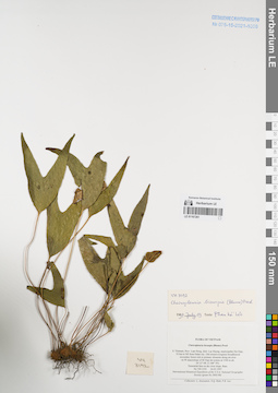
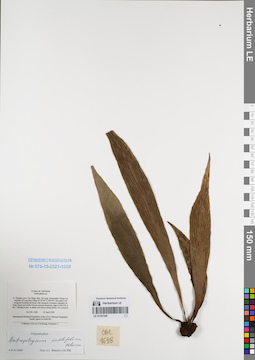
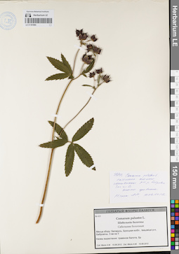
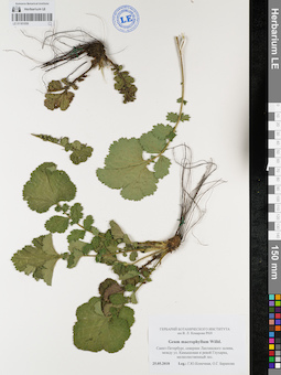
LE 01167261
Cheiropleuria bicuspis (Blume) C.Presl det. Phan Ke Loc at 19.07.1997
Collectors: Averyanov, Leonid Vladimirovich; et al. Field collecting number: VH3192. Collection date: 26.03.1997. Administrative regions: VN - Tinh Lam GJong. Groups of specimens: L. V. Averyanov specimens; L. V. Averyanov herbarium; Соглашение Минобрнауки №075-15-2021-1056Original label text:FLORA OF VIETNAM
Cheiropleuria bicuspis (Blume) Presl
S. Vietnam, Prov. Lam Dong, distr. Lac Duong, municipalite Da Chay,
35 km to NE from Dalat city. Old closed evergreen broadleaved secondary forest rich in primary elements along mt river on W macroslope of Bi Dup mt system at 1500 m alt. (N 12° 08′, E 108° 39′).
Terrestrial fern on dry river slope. Rare. VH 3192 26.03.1997
International Botanical Expedition of the U.S.A. National Geographic
Society (grant No 5803-96)
Collectors: L. Averyanov, N.Q. Binh, P.K. Loc
Coordinates (geographic position): 12° 8′ N, 108° 39′ E ±1000 mRecord creation: 2022-01-18, Galina Savich, PhotoScan D2. Processing status: work_status_1Citation: Specimen LE 01167261 // Virtual herbarium of Komarov Botanical Institute RAS — http://re.herbariumle.ru/01167261Cheiropleuria bicuspis (Blume) Presl
S. Vietnam, Prov. Lam Dong, distr. Lac Duong, municipalite Da Chay,
35 km to NE from Dalat city. Old closed evergreen broadleaved secondary forest rich in primary elements along mt river on W macroslope of Bi Dup mt system at 1500 m alt. (N 12° 08′, E 108° 39′).
Terrestrial fern on dry river slope. Rare. VH 3192 26.03.1997
International Botanical Expedition of the U.S.A. National Geographic
Society (grant No 5803-96)
Collectors: L. Averyanov, N.Q. Binh, P.K. Loc
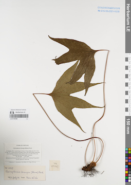
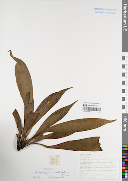
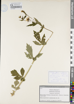
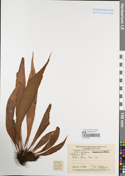
LE 01167260
Cheiropleuria bicuspis (Blume) C.Presl det. Phan Ke Loc at 19.07.1997
Collectors: Averyanov, Leonid Vladimirovich; et al. Field collecting number: VH2587. Collection date: 13.03.1997. Administrative regions: VN - Tinh Lam GJong. Groups of specimens: L. V. Averyanov specimens; L. V. Averyanov herbarium; Соглашение Минобрнауки №075-15-2021-1056Original label text:FLORA OF VIETNAM
Cheiropleuria bicuspis (Blume) Presl
S. Vietnam, Prov. Lam Dong, 8.5 km to S from Dalat city (N 11° 54′,
E 108° 27′). Closed mixed secondary forest with Dacrycarpus imbricatus
rich in primary elements along stream canyon at 1300-1400 m alt.
Terrestrial fern on steep slopes. Common. VH 2587 13.03.1997
International Botanical Expedition of the U.S.A. National Geographic
Society (grant No 5803-96)
Collectors: L. Averyanov, N.Q. Binh, N.V. Duy, P.K. Loc
Coordinates (geographic position): 11° 54′ N, 108° 27′ E ±1000 mRecord creation: 2022-01-18, Galina Savich, PhotoScan D2. Processing status: work_status_1Citation: Specimen LE 01167260 // Virtual herbarium of Komarov Botanical Institute RAS — http://re.herbariumle.ru/01167260Cheiropleuria bicuspis (Blume) Presl
S. Vietnam, Prov. Lam Dong, 8.5 km to S from Dalat city (N 11° 54′,
E 108° 27′). Closed mixed secondary forest with Dacrycarpus imbricatus
rich in primary elements along stream canyon at 1300-1400 m alt.
Terrestrial fern on steep slopes. Common. VH 2587 13.03.1997
International Botanical Expedition of the U.S.A. National Geographic
Society (grant No 5803-96)
Collectors: L. Averyanov, N.Q. Binh, N.V. Duy, P.K. Loc
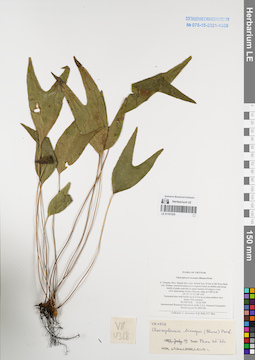
LE 01167259
Cheiropleuria bicuspis (Blume) C.Presl det. Phan Ke Loc at 19.07.1997
Collectors: Averyanov, Leonid Vladimirovich; et al. Field collecting number: VH4328. Collection date: 25.04.1997. Administrative regions: VN - Tinh Khanh Hoa. Groups of specimens: L. V. Averyanov specimens; L. V. Averyanov herbarium; Соглашение Минобрнауки №075-15-2021-1056Original label text:FLORA OF VIETNAM
Cheiropleuria bicuspis (Blume) Presl
S. Vietnam, Prov. Khanh Hoa, distr. Khanh Son, 42 km to NE from Dalat
city. Primary closed broadleaved evergreen forest on shelfes and along
bluffs of giant waterfall in upper reaches of Lieng Ly river
on E macroslope of Hon Giao mt. ridge at 1300 m alt.
(N 12° 12′, E 108° 44′).
Terrestrial fern with fronds up to 0.4 m lg on steep shadow river
slopes. Not common.VH 4328 25.04.1997
International Botanical Expedition of the U.S.A. National Geographic
Society (grant No 5803-96)
Collectors: L. Averyanov, N.Q. Binh, N.T. Hiep
Coordinates (geographic position): 12° 12′ N, 108° 44′ E ±1000 mRecord creation: 2022-01-18, Galina Savich, PhotoScan D2. Processing status: work_status_1Citation: Specimen LE 01167259 // Virtual herbarium of Komarov Botanical Institute RAS — http://re.herbariumle.ru/01167259Cheiropleuria bicuspis (Blume) Presl
S. Vietnam, Prov. Khanh Hoa, distr. Khanh Son, 42 km to NE from Dalat
city. Primary closed broadleaved evergreen forest on shelfes and along
bluffs of giant waterfall in upper reaches of Lieng Ly river
on E macroslope of Hon Giao mt. ridge at 1300 m alt.
(N 12° 12′, E 108° 44′).
Terrestrial fern with fronds up to 0.4 m lg on steep shadow river
slopes. Not common.VH 4328 25.04.1997
International Botanical Expedition of the U.S.A. National Geographic
Society (grant No 5803-96)
Collectors: L. Averyanov, N.Q. Binh, N.T. Hiep
LE 01167258
Cheiropleuria bicuspis (Blume) C.Presl det. Shmakov, Aleksandr Ivanovich at 02.01.2008
Collectors: Phan Ke Loc; Averyanov, Leonid Vladimirovich; et al. Field collecting number: HAL5064. Collection date: 03.05.2004. Administrative regions: VN - Tinh Ha Tinh. Groups of specimens: L. V. Averyanov specimens; L. V. Averyanov herbarium; Соглашение Минобрнауки №075-15-2021-1056Original label text:FLORA OF VIETNAM
Polypodiaceae s.l.
Neocheiropleuria bicuspis
N.Vietnam, Ha Tinh Prov., Huong Son Distr., Son Kim Municipality, Rao
Bun stream around point 18°23′39′'N, 105°15′12′'E. Primary coniferous
closed forest with Fokienia hodginsii and Dacrydium elatum along ridge
rib and on slopes near the ridge tops at elevation 1100-1200 m a.s.l.
(Kho Mu mt.).
Terrestrial fern on very steep and vertical mossy shady slope.
Occasional. HAL 5064 3 May 2004
Collectors: P.K.Loc, L.Averyanov, P.V.The, N.T.Vinh.
Coordinates (geographic position): 18° 23′ 39″ N, 105° 15′ 12″ E ±1000 mRecord creation: 2022-01-18, Galina Savich, PhotoScan D2. Processing status: work_status_1Citation: Specimen LE 01167258 // Virtual herbarium of Komarov Botanical Institute RAS — http://re.herbariumle.ru/01167258Polypodiaceae s.l.
Neocheiropleuria bicuspis
N.Vietnam, Ha Tinh Prov., Huong Son Distr., Son Kim Municipality, Rao
Bun stream around point 18°23′39′'N, 105°15′12′'E. Primary coniferous
closed forest with Fokienia hodginsii and Dacrydium elatum along ridge
rib and on slopes near the ridge tops at elevation 1100-1200 m a.s.l.
(Kho Mu mt.).
Terrestrial fern on very steep and vertical mossy shady slope.
Occasional. HAL 5064 3 May 2004
Collectors: P.K.Loc, L.Averyanov, P.V.The, N.T.Vinh.
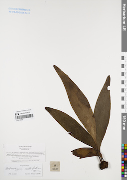
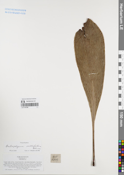
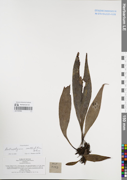
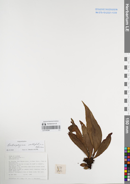
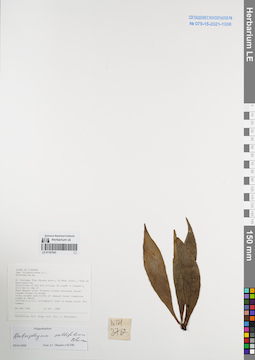
LE 01167257
Antrophyum callifolium Blume det. Shmakov, Aleksandr Ivanovich at 02.01.2008
Collectors: Averyanov, Leonid Vladimirovich; et al. Field collecting number: HAL5189. Collection date: 08.05.2004. Administrative regions: VN - Tinh Ha Tinh. Groups of specimens: L. V. Averyanov specimens; L. V. Averyanov herbarium; Соглашение Минобрнауки №075-15-2021-1056Original label text:FLORA OF VIETNAM
Polypodiaceae s.l.
Antrophyum sp.
N.Vietnam, Ha Tinh Prov., Huong Son Distr., Son Hong Municipality,
around point 18°34′06′'N, 105°11′40′'E. Primary broad-leaved evergreen
forest on steep mt slopes composed with granite along Khe Van stream
at elev 350-450 m a.s.l. Epiphyte in shady stream canyon. Occasional.
HAL 5189 8 May 2004
Collectors: P.K.Loc, L.Averyanov, P.V.The, N.T.Vinh.
Coordinates (geographic position): 18° 34′ 6″ N, 105° 11′ 40″ E ±1000 mRecord creation: 2022-01-18, Galina Savich, PhotoScan D2. Processing status: work_status_1Citation: Specimen LE 01167257 // Virtual herbarium of Komarov Botanical Institute RAS — http://re.herbariumle.ru/01167257Polypodiaceae s.l.
Antrophyum sp.
N.Vietnam, Ha Tinh Prov., Huong Son Distr., Son Hong Municipality,
around point 18°34′06′'N, 105°11′40′'E. Primary broad-leaved evergreen
forest on steep mt slopes composed with granite along Khe Van stream
at elev 350-450 m a.s.l. Epiphyte in shady stream canyon. Occasional.
HAL 5189 8 May 2004
Collectors: P.K.Loc, L.Averyanov, P.V.The, N.T.Vinh.
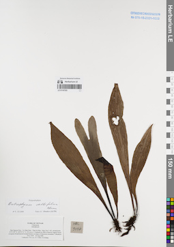
LE 01167256
Antrophyum callifolium Blume det. Shmakov, Aleksandr Ivanovich at 02.01.2008
Collectors: Averyanov, Leonid Vladimirovich; et al. Field collecting number: HLF6619. Collection date: 17.03.2007. Administrative regions: VN - Tinh Nghe An. Groups of specimens: L. V. Averyanov specimens; L. V. Averyanov herbarium; Соглашение Минобрнауки №075-15-2021-1056Original label text:FLORA OF VIETNAM
Polypodiaceae s.l.
Anthrophium sp.
Vietnam, Nghe An Prov., Tuong Duong Distr., Tam Quang Municipality, Tung Huong village, along Khe Mat stream around point 19°03′07″N 104°36′57″E at elevation about 355 m a.s.l.
Lowland closed secondary old evergreen forest on steep slopes along rocky stream valley composed with stratified solid shale and sandstone. Epiphyte on mossy old trees along rocky shady stream valley. Not common.
HLF 6619 17 March 2007.
Coll. Averyanov L., P.K.Loc, N.V.Trai, N.T.Vinh, N.D.Phuong, Averyanova A.
Grant from Henry Luce Foundation.
Coordinates (geographic position): 19° 3′ 7″ N, 104° 36′ 57″ E ±1000 mRecord creation: 2022-01-18, Galina Savich, PhotoScan D2. Processing status: work_status_1Citation: Specimen LE 01167256 // Virtual herbarium of Komarov Botanical Institute RAS — http://re.herbariumle.ru/01167256Polypodiaceae s.l.
Anthrophium sp.
Vietnam, Nghe An Prov., Tuong Duong Distr., Tam Quang Municipality, Tung Huong village, along Khe Mat stream around point 19°03′07″N 104°36′57″E at elevation about 355 m a.s.l.
Lowland closed secondary old evergreen forest on steep slopes along rocky stream valley composed with stratified solid shale and sandstone. Epiphyte on mossy old trees along rocky shady stream valley. Not common.
HLF 6619 17 March 2007.
Coll. Averyanov L., P.K.Loc, N.V.Trai, N.T.Vinh, N.D.Phuong, Averyanova A.
Grant from Henry Luce Foundation.
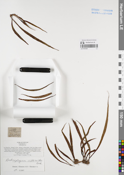
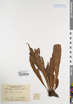
LE 01167255
Antrophyum vittarioides Baker det. Shmakov, Aleksandr Ivanovich at 29.12.2007
Collectors: Tien Hiep Nguyen; Averyanov, Leonid Vladimirovich; The Van Pham Field collecting number: HAL10104. Collection date: 23.11.2006. Administrative regions: VN - Tinh Lai Chau. Groups of specimens: L. V. Averyanov specimens; L. V. Averyanov herbarium; Соглашение Минобрнауки №075-15-2021-1056Original label text:FLORA OF VIETNAM
Polypodiaceae s.l.
Anthrophium sp.
Lai Chau Prov., Muong Te Distr., Muong Te Municipality, Nam Cum village, around point 22°32′06″N 102°32′29″E. Secondary evergreen forest with bamboo on very steep slopes of remnant bluffly mountain composed with slid gray highly eroded limestone along Song Da River canyon at elev. 300-600 m a.s.l.
Epiphyte on mossy trees along river. Locally common. HAL 10104 23 Nov. 2006
Coll.: Nguyen Tien Hiep, L.Averyanov, Pham Van The.
Coordinates (geographic position): 22° 32′ 6″ N, 102° 32′ 29″ E ±1000 mRecord creation: 2022-01-18, Galina Savich, PhotoScan D2. Processing status: work_status_1Citation: Specimen LE 01167255 // Virtual herbarium of Komarov Botanical Institute RAS — http://re.herbariumle.ru/01167255Polypodiaceae s.l.
Anthrophium sp.
Lai Chau Prov., Muong Te Distr., Muong Te Municipality, Nam Cum village, around point 22°32′06″N 102°32′29″E. Secondary evergreen forest with bamboo on very steep slopes of remnant bluffly mountain composed with slid gray highly eroded limestone along Song Da River canyon at elev. 300-600 m a.s.l.
Epiphyte on mossy trees along river. Locally common. HAL 10104 23 Nov. 2006
Coll.: Nguyen Tien Hiep, L.Averyanov, Pham Van The.
LE 01167254
Antrophyum callifolium Blume det. Shmakov, Aleksandr Ivanovich at 02.01.2008
Collectors: Phan Ke Loc; et al. Field collecting number: HLF5782. Collection date: 23.03.2006. Administrative regions: VN - Tinh Quang Tri. Groups of specimens: L. V. Averyanov specimens; L. V. Averyanov herbarium; Соглашение Минобрнауки №075-15-2021-1056Original label text:FLORA OF VIETNAM
Plants of the Da Krong Nature Reserve
Vittariaceae
Antrophyum annamensis
Vietnam, Quang Tri Prov., Da Krong Distr., Huc Nghi Municipality, La To Vill., along La Sam stream, around point 16°29′00″ N, 107°00′40″ E, 432 m a.s.l., shaly mt. Epiphyte and lithophyte. In secondary closed evergreen broad-leaved mixte with bamboo forest; rare. HLF 5782 23 Mar 2006.
Coll.: P.K. Loc. N.V. Huy, H.T. Phuong, D.C. Tri, T.T. Tu.
Grant from Henry Luce Foundation.
Record creation: 2022-01-18, Galina Savich, PhotoScan D2. Processing status: work_status_1Citation: Specimen LE 01167254 // Virtual herbarium of Komarov Botanical Institute RAS — http://re.herbariumle.ru/01167254Plants of the Da Krong Nature Reserve
Vittariaceae
Antrophyum annamensis
Vietnam, Quang Tri Prov., Da Krong Distr., Huc Nghi Municipality, La To Vill., along La Sam stream, around point 16°29′00″ N, 107°00′40″ E, 432 m a.s.l., shaly mt. Epiphyte and lithophyte. In secondary closed evergreen broad-leaved mixte with bamboo forest; rare. HLF 5782 23 Mar 2006.
Coll.: P.K. Loc. N.V. Huy, H.T. Phuong, D.C. Tri, T.T. Tu.
Grant from Henry Luce Foundation.
LE 01167253
Antrophyum callifolium Blume det. Shmakov, Aleksandr Ivanovich at 02.01.2008
Collectors: Phan Ke Loc; et al. Field collecting number: HAL9194. Collection date: 30.08.2006. Administrative regions: VN - Tinh Thai Nguyen. Groups of specimens: L. V. Averyanov specimens; L. V. Averyanov herbarium; Соглашение Минобрнауки №075-15-2021-1056Original label text:FLORA OF VIETNAM
Vittariaceae
Antrophyum
Record creation: 2022-01-18, Galina Savich, PhotoScan D2. Processing status: work_status_1Citation: Specimen LE 01167253 // Virtual herbarium of Komarov Botanical Institute RAS — http://re.herbariumle.ru/01167253Vittariaceae
Antrophyum
Thai Nguyen Prov., Vo Nhai Distr., Than Sa Mun., Ngoc Son 2 vill., around point 21?51′09″ N, 105?53′51″ E, 253 m a.s.l. Clustered on cliffs of heavily logged closed evergreen broad-leaved lowland forests on slopes of limestone mountains. Lithophyte. HAL 9194 30 Aug 2006 Id. by Phan Ke Loc
Collectors: Phan Ke Loc, Nguyen Tien Vinh and Nguyen Sinh Khang
Collected with the financial support from NYBG, U.S.A.
Collectors: Phan Ke Loc, Nguyen Tien Vinh and Nguyen Sinh Khang
Collected with the financial support from NYBG, U.S.A.
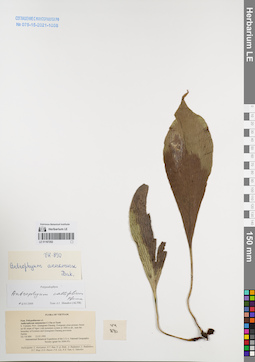
LE 01167252
Antrophyum callifolium Blume det. Shmakov, Aleksandr Ivanovich at 02.01.2008
Collectors: Averyanov, Leonid Vladimirovich; et al. Field collecting number: VH890. Collection date: 23.03.1995. Administrative regions: VN - Tinh Quang Nam. Groups of specimens: L. V. Averyanov specimens; L. V. Averyanov herbarium; Соглашение Минобрнауки №075-15-2021-1056Original label text:FLORA OF VIETNAM
Polypodiaceae s.l.
Anthrophyum annamense C.Chr.et Tard.
S. Vietnam, Prov. Quangnam-Danang. Evergreen close primary forest
on SE slope of Ngoc Linh mountain system at 1800 m alt., near the
boundary of Kontum and Quangnam-Danang provinces.
Epilite. VH 890 23.03.1995
International Botanical Expedition of the U.S.A. National Geographic
Society (grant No 5094-93)
Participants: L. Averyanov, N.T. Ban, N. Q. Binh, A. Budantzev, L. Budantzev, N.T. Hiep, D.D. Huyen, P.K. Loc, N.X. Tam, G. Yakovlev
Record creation: 2022-01-18, Galina Savich, PhotoScan D2. Processing status: work_status_1Citation: Specimen LE 01167252 // Virtual herbarium of Komarov Botanical Institute RAS — http://re.herbariumle.ru/01167252Polypodiaceae s.l.
Anthrophyum annamense C.Chr.et Tard.
S. Vietnam, Prov. Quangnam-Danang. Evergreen close primary forest
on SE slope of Ngoc Linh mountain system at 1800 m alt., near the
boundary of Kontum and Quangnam-Danang provinces.
Epilite. VH 890 23.03.1995
International Botanical Expedition of the U.S.A. National Geographic
Society (grant No 5094-93)
Participants: L. Averyanov, N.T. Ban, N. Q. Binh, A. Budantzev, L. Budantzev, N.T. Hiep, D.D. Huyen, P.K. Loc, N.X. Tam, G. Yakovlev
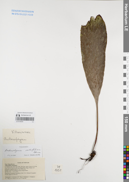
LE 01167251
Antrophyum callifolium Blume det. Shmakov, Aleksandr Ivanovich at 02.01.2008
Collectors: Averyanov, Leonid Vladimirovich; et al. Field collecting number: VH1751. Collection date: 17.11.1995. Administrative regions: VN - Kon Tum. Groups of specimens: L. V. Averyanov specimens; L. V. Averyanov herbarium; Соглашение Минобрнауки №075-15-2021-1056Original label text:FLORA OF VIETNAM
Polypodiaceae
Anthrophium annamense
S. Vietnam, Prov. Kon Tum, Distr. Dak Gley, about 12 km to N of Dak
Gley town (24 km by road), near Mang Khen village. Primary wet
mountain evergreen forest at 1100-1200 m alt.
Epiphite. Rare, in wet shadow places along streams.
VH 1751 17.11.1995
International Botanical Expedition of the U.S.A. National Geographic
Society (grant No 5094-93)
Participants: L. Averyanov, N.T. Ban, A. Budantzev, L. Budantzev,
N.T. Hiep, D.D. Huyen, P.K. Loc, G. Yakovlev
Record creation: 2022-01-18, Galina Savich, PhotoScan D2. Processing status: work_status_1Citation: Specimen LE 01167251 // Virtual herbarium of Komarov Botanical Institute RAS — http://re.herbariumle.ru/01167251Polypodiaceae
Anthrophium annamense
S. Vietnam, Prov. Kon Tum, Distr. Dak Gley, about 12 km to N of Dak
Gley town (24 km by road), near Mang Khen village. Primary wet
mountain evergreen forest at 1100-1200 m alt.
Epiphite. Rare, in wet shadow places along streams.
VH 1751 17.11.1995
International Botanical Expedition of the U.S.A. National Geographic
Society (grant No 5094-93)
Participants: L. Averyanov, N.T. Ban, A. Budantzev, L. Budantzev,
N.T. Hiep, D.D. Huyen, P.K. Loc, G. Yakovlev
LE 01167250
Antrophyum callifolium Blume det. Shmakov, Aleksandr Ivanovich at 02.01.2008
Collectors: Averyanov, Leonid Vladimirovich; Phan Ke Loc; et al. Field collecting number: HLF5973. Collection date: 31.03.2006. Administrative regions: VN - Tinh Quang Tri. Groups of specimens: L. V. Averyanov specimens; L. V. Averyanov herbarium; Соглашение Минобрнауки №075-15-2021-1056Original label text:FLORA OF VIETNAM
Polypodiaceae s.l. (Vittariaceae)
Antrophyum sp.
Vietnam, Quang Tri Prov., Huong Hoa Distr., Huong Viet Municipality, to N of Sa Mui pass, around point 16°51′14″N 106°34′13″E at elevation 550-650 m a.s.l.
Remnants of primary broad-leaved evergreen lowland forest on rocky remnant highly eroded solid marble-like limestone hills and low mountains with very steep slopes and vertical cliffs. Terrestrial fern on shady slope. Common. HLF 5973 31 March 2006.
Coll. N.T.Hiep, L.Averyanov, P.K.Loc, P.V.The, N.S.Khang, P.H.Duc, L.T.Son, S.Bounphanmy, T.K.Ratana, O.Sonliya, T.Q.Dang, N.V.Hien, H.T.N.Trang, L.T.Chau.
Grant from Henry Luce Foundation.
Coordinates (geographic position): 16° 51′ 14″ N, 106° 34′ 13″ E ±1000 mRecord creation: 2022-01-18, Galina Savich, PhotoScan D2. Processing status: work_status_1Citation: Specimen LE 01167250 // Virtual herbarium of Komarov Botanical Institute RAS — http://re.herbariumle.ru/01167250Polypodiaceae s.l. (Vittariaceae)
Antrophyum sp.
Vietnam, Quang Tri Prov., Huong Hoa Distr., Huong Viet Municipality, to N of Sa Mui pass, around point 16°51′14″N 106°34′13″E at elevation 550-650 m a.s.l.
Remnants of primary broad-leaved evergreen lowland forest on rocky remnant highly eroded solid marble-like limestone hills and low mountains with very steep slopes and vertical cliffs. Terrestrial fern on shady slope. Common. HLF 5973 31 March 2006.
Coll. N.T.Hiep, L.Averyanov, P.K.Loc, P.V.The, N.S.Khang, P.H.Duc, L.T.Son, S.Bounphanmy, T.K.Ratana, O.Sonliya, T.Q.Dang, N.V.Hien, H.T.N.Trang, L.T.Chau.
Grant from Henry Luce Foundation.
LE 01167249
Antrophyum callifolium Blume det. Shmakov, Aleksandr Ivanovich at 02.01.2008
Collectors: Phan Ke Loc; P.H. Hoang; Averyanov, Leonid Vladimirovich Field collecting number: CBL1638. Collection date: 23.04.1999. Administrative regions: VN - Tinh Cao Bang. Groups of specimens: L. V. Averyanov specimens; L. V. Averyanov herbarium; Соглашение Минобрнауки №075-15-2021-1056Original label text:FLORA OF VIETNAM
Anthrophium sp.
N. Vietnam, prov. Cao Bang, distr. Ha Lang, municipality Thang Loi,
vicinities of Lung Sam village (N 22°45′ E 106°42′). Secondary wet
evergreen broadleaved forest with remnants of primary elements on
steep slopes and bluffs of karst remnant limestone ridge at 500-550 m
elev. Lithophyte fern in shady wet canyon along stream. Not common.
CBL 1638 23 April 1999
International Botanical Expedition of the U.S.A. National Geographic
Society (grant No 6300-98)
Collectors: P.K.Loc, P.H.Hoang, Averyanov L.
Coordinates (geographic position): 22° 45′ N, 106° 42′ E ±1000 mRecord creation: 2022-01-18, Galina Savich, PhotoScan D2. Processing status: work_status_1Citation: Specimen LE 01167249 // Virtual herbarium of Komarov Botanical Institute RAS — http://re.herbariumle.ru/01167249Anthrophium sp.
N. Vietnam, prov. Cao Bang, distr. Ha Lang, municipality Thang Loi,
vicinities of Lung Sam village (N 22°45′ E 106°42′). Secondary wet
evergreen broadleaved forest with remnants of primary elements on
steep slopes and bluffs of karst remnant limestone ridge at 500-550 m
elev. Lithophyte fern in shady wet canyon along stream. Not common.
CBL 1638 23 April 1999
International Botanical Expedition of the U.S.A. National Geographic
Society (grant No 6300-98)
Collectors: P.K.Loc, P.H.Hoang, Averyanov L.
LE 01167248
Antrophyum callifolium Blume det. Shmakov, Aleksandr Ivanovich at 02.01.2008
Collectors: Tien Hiep Nguyen; Phan Ke Loc; Averyanov, Leonid Vladimirovich Field collecting number: NTH3887. Collection date: 24.10.1999. Administrative regions: VN - Tinh Thai Nguyen. Groups of specimens: L. V. Averyanov specimens; L. V. Averyanov herbarium; Соглашение Минобрнауки №075-15-2021-1056Original label text:FLORA OF VIETNAM
Polypodiaceae s.l.
Anthrophium sp.
N. Vietnam, Thai Nguyen prov., Vo Nhai distr., Than Sa municipality,
vicinities of Kim Son village (N 21°48′ E 105°54′), 23.3 km to 18° of
Thai Nguyen city. Primary dry broadleaved evergreen forest on very
steep rocky slopes of remnant karst limestone ridge at elev. about 300
m a.s.l. Epiphyte on mossy trees in shady places. Not rare.
NTH 3887 24 Oct. 1999
Collectors: N.T. Hiep, P.K. Loc, L. Averyanov.
Coordinates (geographic position): 21° 48′ N, 105° 54′ E ±1000 mRecord creation: 2022-01-18, Galina Savich, PhotoScan D2. Processing status: work_status_1Citation: Specimen LE 01167248 // Virtual herbarium of Komarov Botanical Institute RAS — http://re.herbariumle.ru/01167248Polypodiaceae s.l.
Anthrophium sp.
N. Vietnam, Thai Nguyen prov., Vo Nhai distr., Than Sa municipality,
vicinities of Kim Son village (N 21°48′ E 105°54′), 23.3 km to 18° of
Thai Nguyen city. Primary dry broadleaved evergreen forest on very
steep rocky slopes of remnant karst limestone ridge at elev. about 300
m a.s.l. Epiphyte on mossy trees in shady places. Not rare.
NTH 3887 24 Oct. 1999
Collectors: N.T. Hiep, P.K. Loc, L. Averyanov.
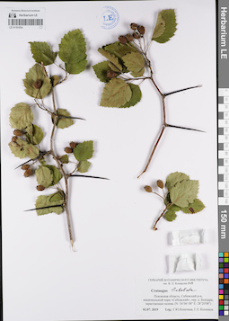
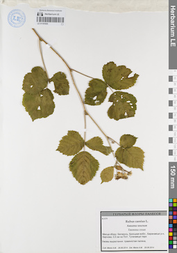
LE 01181065
Groups of specimens: Образцы сектора Восточной Европы; Соглашение Минобрнауки №075-15-2021-1056Record creation: 2022-01-18, Larisa Orlova, PhotoScan D2Citation: Specimen LE 01181065 // Virtual herbarium of Komarov Botanical Institute RAS — http://re.herbariumle.ru/01181065
LE 01167247
Antrophyum callifolium Blume det. Shmakov, Aleksandr Ivanovich at 02.01.2008
Collectors: Averyanov, Leonid Vladimirovich; et al. Field collecting number: HAL10892. Collection date: 05.04.2007. Administrative regions: VN - Tinh Thua Thien-Hue. Groups of specimens: L. V. Averyanov specimens; L. V. Averyanov herbarium; Соглашение Минобрнауки №075-15-2021-1056Original label text:FLORA OF VIETNAM
Polypodiaceae s.l.
Antrophium sp.
Thua Thien – Hue Prov., Nam Dong Distr., Thuong Lo Municipality, along Cha Mang stream, around point 16°07′46″N 107°44′24″E. nants of primary evergreen broad-leaved lowland forest on very steep hill slopes composed with stratified shale and sandstone at elev. about 250-300 m a.s.l. Lithophyte along shady rocky stream. Common. HAL 10892 5 Apr. 2007.
Coll.: L.Averyanov, Phan Ke Loc, A.Averyanova, N.D.Phuong, L.V.Hung.
Coordinates (geographic position): 16° 7′ 46″ N, 107° 44′ 24″ E ±1000 mRecord creation: 2022-01-18, Galina Savich, PhotoScan D2. Processing status: work_status_1Citation: Specimen LE 01167247 // Virtual herbarium of Komarov Botanical Institute RAS — http://re.herbariumle.ru/01167247Polypodiaceae s.l.
Antrophium sp.
Thua Thien – Hue Prov., Nam Dong Distr., Thuong Lo Municipality, along Cha Mang stream, around point 16°07′46″N 107°44′24″E. nants of primary evergreen broad-leaved lowland forest on very steep hill slopes composed with stratified shale and sandstone at elev. about 250-300 m a.s.l. Lithophyte along shady rocky stream. Common. HAL 10892 5 Apr. 2007.
Coll.: L.Averyanov, Phan Ke Loc, A.Averyanova, N.D.Phuong, L.V.Hung.
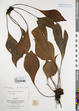
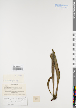
LE 01181064
Groups of specimens: Образцы сектора Восточной Европы; Соглашение Минобрнауки №075-15-2021-1056Record creation: 2022-01-18, Larisa Orlova, PhotoScan D2Citation: Specimen LE 01181064 // Virtual herbarium of Komarov Botanical Institute RAS — http://re.herbariumle.ru/01181064
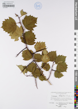
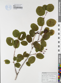
LE 01181063
Groups of specimens: Образцы сектора Восточной Европы; Соглашение Минобрнауки №075-15-2021-1056Record creation: 2022-01-18, Larisa Orlova, PhotoScan D2Citation: Specimen LE 01181063 // Virtual herbarium of Komarov Botanical Institute RAS — http://re.herbariumle.ru/01181063
LE 01167246
Antrophyum callifolium Blume det. Shmakov, Aleksandr Ivanovich at 02.01.2008
Collectors: Tien Hiep Nguyen; Phan Ke Loc; Averyanov, Leonid Vladimirovich Field collecting number: NTH3864. Collection date: 24.10.1999. Administrative regions: VN - Tinh Thai Nguyen. Groups of specimens: L. V. Averyanov specimens; L. V. Averyanov herbarium; Соглашение Минобрнауки №075-15-2021-1056Original label text:FLORA OF VIETNAM
Polypodiaceae s.l.
Anthrophium sp.
N. Vietnam, Thai Nguyen prov., Vo Nhai distr., Than Sa municipality,
vicinities of Kim Son village (N 21°48′ E 105°54′), 23.3 km to 18° of
Thai Nguyen city. Secondary open broadleaved forest and shrubs on very
steep rocky slopes of remnant karst limestone ridge at elev. about 100
m a.s.l. Lithophytic fern on shady rocks. Not rare. NTH 3864 24 Oct. 1999
Collectors: N.T. Hiep, P.K. Loc, L. Averyanov.
Coordinates (geographic position): 21° 48′ N, 105° 54′ E ±1000 mRecord creation: 2022-01-18, Galina Savich, PhotoScan D2. Processing status: work_status_1Citation: Specimen LE 01167246 // Virtual herbarium of Komarov Botanical Institute RAS — http://re.herbariumle.ru/01167246Polypodiaceae s.l.
Anthrophium sp.
N. Vietnam, Thai Nguyen prov., Vo Nhai distr., Than Sa municipality,
vicinities of Kim Son village (N 21°48′ E 105°54′), 23.3 km to 18° of
Thai Nguyen city. Secondary open broadleaved forest and shrubs on very
steep rocky slopes of remnant karst limestone ridge at elev. about 100
m a.s.l. Lithophytic fern on shady rocks. Not rare. NTH 3864 24 Oct. 1999
Collectors: N.T. Hiep, P.K. Loc, L. Averyanov.
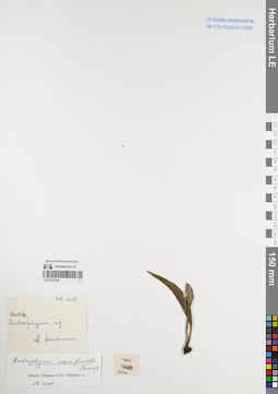
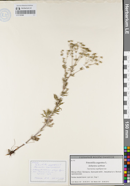
LE 01181062
Groups of specimens: Образцы сектора Восточной Европы; Соглашение Минобрнауки №075-15-2021-1056Record creation: 2022-01-18, Larisa Orlova, PhotoScan D2Citation: Specimen LE 01181062 // Virtual herbarium of Komarov Botanical Institute RAS — http://re.herbariumle.ru/01181062
LE 01167245
Antrophyum callifolium Blume det. Shmakov, Aleksandr Ivanovich at 02.01.2008
Collectors: Tien Hiep Nguyen; Phan Ke Loc; Averyanov, Leonid Vladimirovich Field collecting number: NTH3819. Collection date: 23.10.1999. Administrative regions: VN - Tinh Thai Nguyen. Groups of specimens: L. V. Averyanov specimens; L. V. Averyanov herbarium; Соглашение Минобрнауки №075-15-2021-1056Original label text:FLORA OF VIETNAM
Polypodiaceae s.l.
Anthrophium sp.
N. Vietnam, Thai Nguyen prov., Vo Nhai distr., Than Sa municipality,
vicinities of Kim Son village (N 21°48′ E 105°54′), 23.3 km to 18° of
Thai Nguyen city. Primary broadleaved evergreen dry forest on very
steep rocky slopes of karst remnant limestone ridge at elev. 300-450 m
a.s.l. Epiphyte on mossy trees in shady place. Not rare.
NTH 3819 23 Oct. 1999
Collectors: N.T. Hiep, P.K. Loc, L. Averyanov.
Coordinates (geographic position): 21° 48′ N, 105° 54′ E ±1000 mRecord creation: 2022-01-18, Galina Savich, PhotoScan D2. Processing status: work_status_1Citation: Specimen LE 01167245 // Virtual herbarium of Komarov Botanical Institute RAS — http://re.herbariumle.ru/01167245Polypodiaceae s.l.
Anthrophium sp.
N. Vietnam, Thai Nguyen prov., Vo Nhai distr., Than Sa municipality,
vicinities of Kim Son village (N 21°48′ E 105°54′), 23.3 km to 18° of
Thai Nguyen city. Primary broadleaved evergreen dry forest on very
steep rocky slopes of karst remnant limestone ridge at elev. 300-450 m
a.s.l. Epiphyte on mossy trees in shady place. Not rare.
NTH 3819 23 Oct. 1999
Collectors: N.T. Hiep, P.K. Loc, L. Averyanov.
LE 01181061
Groups of specimens: Образцы сектора Восточной Европы; Соглашение Минобрнауки №075-15-2021-1056Record creation: 2022-01-18, Larisa Orlova, PhotoScan D2Citation: Specimen LE 01181061 // Virtual herbarium of Komarov Botanical Institute RAS — http://re.herbariumle.ru/01181061
LE 01167244
Antrophyum callifolium Blume det. Shmakov, Aleksandr Ivanovich at 02.01.2008
Collectors: Averyanov, Leonid Vladimirovich; N.Q. Binh; Nguyen Xuan Tam Field collecting number: CBL952. Collection date: 06.12.1998. Administrative regions: VN - Tinh Cao Bang. Groups of specimens: L. V. Averyanov specimens; L. V. Averyanov herbarium; Соглашение Минобрнауки №075-15-2021-1056Original label text:FLORA OF VIETNAM
Polypodiaceae s.l.
Anthrophium sp. ?
N. Vietnam, prov. Cao Bang, distr. Thach An, about 28 km to SE from
Cao Bang town (N 22°29′ E 106°28). Primary evergreen broadleaved
closed wet forest along deep shadow canyon of remnant limestone ridge
at 300-400 m alt. Epilite fern on shadow waterfall cliffs. Rare.
CBL 952 06 Dec. 1998
International Botanical Expedition of the U.S.A. National Geographic
Society (grant No 6300-98)
Collectors: Averyanov L., N.Q.Binh, N.X.Tam.
Coordinates (geographic position): 22° 29′ N, 106° 28′ E ±1000 mRecord creation: 2022-01-18, Galina Savich, PhotoScan D2. Processing status: work_status_1Citation: Specimen LE 01167244 // Virtual herbarium of Komarov Botanical Institute RAS — http://re.herbariumle.ru/01167244Polypodiaceae s.l.
Anthrophium sp. ?
N. Vietnam, prov. Cao Bang, distr. Thach An, about 28 km to SE from
Cao Bang town (N 22°29′ E 106°28). Primary evergreen broadleaved
closed wet forest along deep shadow canyon of remnant limestone ridge
at 300-400 m alt. Epilite fern on shadow waterfall cliffs. Rare.
CBL 952 06 Dec. 1998
International Botanical Expedition of the U.S.A. National Geographic
Society (grant No 6300-98)
Collectors: Averyanov L., N.Q.Binh, N.X.Tam.
LE 01181060
Groups of specimens: Образцы сектора Восточной Европы; Соглашение Минобрнауки №075-15-2021-1056Record creation: 2022-01-18, Larisa Orlova, PhotoScan D2Citation: Specimen LE 01181060 // Virtual herbarium of Komarov Botanical Institute RAS — http://re.herbariumle.ru/01181060
LE 01167243
Antrophyum callifolium Blume det. Shmakov, Aleksandr Ivanovich at 02.01.2008
Collectors: Tien Hiep Nguyen; Phan Ke Loc; Averyanov, Leonid Vladimirovich Field collecting number: NTH3762. Collection date: 22.10.1999. Administrative regions: VN - Tinh Thai Nguyen. Groups of specimens: L. V. Averyanov specimens; L. V. Averyanov herbarium; Соглашение Минобрнауки №075-15-2021-1056Original label text:FLORA OF VIETNAM
Polypodiaceae s.l.
Anthrophium sp.
N. Vietnam, Thai Nguyen prov., Vo Nhai distr., Than Sa municipality,
vicinities of Kim Son village (N 21°48′ E 105°54′), 23.3 km to 18° of
Thai Nguyen city. Primary closed evergreen broadleaved forest on steep
rocky slopes and cliffs of remnant karst limestone ridge at about
100-200 m a.s.l. Lithophytic fern in shady place. Not common.
NTH 3762 22 Oct. 1999
Collectors: N.T. Hiep, P.K. Loc, L. Averyanov.
Coordinates (geographic position): 21° 48′ N, 105° 54′ E ±1000 mRecord creation: 2022-01-18, Galina Savich, PhotoScan D2. Processing status: work_status_1Citation: Specimen LE 01167243 // Virtual herbarium of Komarov Botanical Institute RAS — http://re.herbariumle.ru/01167243Polypodiaceae s.l.
Anthrophium sp.
N. Vietnam, Thai Nguyen prov., Vo Nhai distr., Than Sa municipality,
vicinities of Kim Son village (N 21°48′ E 105°54′), 23.3 km to 18° of
Thai Nguyen city. Primary closed evergreen broadleaved forest on steep
rocky slopes and cliffs of remnant karst limestone ridge at about
100-200 m a.s.l. Lithophytic fern in shady place. Not common.
NTH 3762 22 Oct. 1999
Collectors: N.T. Hiep, P.K. Loc, L. Averyanov.
LE 01181059
Groups of specimens: Образцы сектора Восточной Европы; Соглашение Минобрнауки №075-15-2021-1056Record creation: 2022-01-18, Larisa Orlova, PhotoScan D2Citation: Specimen LE 01181059 // Virtual herbarium of Komarov Botanical Institute RAS — http://re.herbariumle.ru/01181059
LE 01167242
Antrophyum callifolium Blume det. Takhtajan, Armen Leonovich. at 21.01.1975
Collectors: Takhtajan, Armen Leonovich. Field collecting number: Takhtajan 8492. Collection date: 21.01.1975. Administrative regions: VN - Tinh Lao Cai. Groups of specimens: L. V. Averyanov specimens; L. V. Averyanov herbarium; Соглашение Минобрнауки №075-15-2021-1056Original label text:FLORA OF VIETNAM
Antrophyum callifolium Blume.
Record creation: 2022-01-18, Galina Savich, PhotoScan D2Citation: Specimen LE 01167242 // Virtual herbarium of Komarov Botanical Institute RAS — http://re.herbariumle.ru/01167242Antrophyum callifolium Blume.
Lao Cai Prov.
Takhtajan 8492, 21.01.1975
LE 01181058
Groups of specimens: Образцы сектора Восточной Европы; Соглашение Минобрнауки №075-15-2021-1056Record creation: 2022-01-18, Larisa Orlova, PhotoScan D2Citation: Specimen LE 01181058 // Virtual herbarium of Komarov Botanical Institute RAS — http://re.herbariumle.ru/01181058
LE 01167241
Antrophyum callifolium Blume det. Takhtajan, Armen Leonovich. at 21.01.1975
Collectors: Takhtajan, Armen Leonovich. Field collecting number: Takhtajan 8492. Collection date: 21.01.1975. Administrative regions: VN - Tinh Lao Cai. Groups of specimens: L. V. Averyanov specimens; L. V. Averyanov herbarium; Соглашение Минобрнауки №075-15-2021-1056Original label text:FLORA OF VIETNAM
Record creation: 2022-01-18, Galina Savich, PhotoScan D2Citation: Specimen LE 01167241 // Virtual herbarium of Komarov Botanical Institute RAS — http://re.herbariumle.ru/01167241Antrophyum callifolium Blume
Lao Cai Prov., Takhtajan 8492.
21.01.1975
LE 01181057
Groups of specimens: Образцы сектора Восточной Европы; Соглашение Минобрнауки №075-15-2021-1056Record creation: 2022-01-18, Larisa Orlova, PhotoScan D2Citation: Specimen LE 01181057 // Virtual herbarium of Komarov Botanical Institute RAS — http://re.herbariumle.ru/01181057
LE 01167240
Antrophyum callifolium Blume det. Takhtajan, Armen Leonovich. at 30.01.1975
Collectors: Takhtajan, Armen Leonovich. Field collecting number: Takhtajan 8645. Collection date: 30.01.1975. Administrative regions: VN - Vietnam. Groups of specimens: L. V. Averyanov specimens; L. V. Averyanov herbarium; Соглашение Минобрнауки №075-15-2021-1056Original label text:FLORA OF VIETNAM
Antrophyum callifolium Blume.
Record creation: 2022-01-18, Galina Savich, PhotoScan D2Citation: Specimen LE 01167240 // Virtual herbarium of Komarov Botanical Institute RAS — http://re.herbariumle.ru/01167240Antrophyum callifolium Blume.
Takhtajan 8645, 30.01.1975
LE 01181056
Groups of specimens: Образцы сектора Восточной Европы; Соглашение Минобрнауки №075-15-2021-1056Record creation: 2022-01-18, Larisa Orlova, PhotoScan D2Citation: Specimen LE 01181056 // Virtual herbarium of Komarov Botanical Institute RAS — http://re.herbariumle.ru/01181056
LE 01167239
Antrophyum parvulum Blume det. Shmakov, Aleksandr Ivanovich at 29.12.2007
Collectors: Tien Hiep Nguyen; N.Q. Binh; Averyanov, Leonid Vladimirovich; P. Cribb Field collecting number: NTH3530. Collection date: 10.10.1999. Administrative regions: VN - Tinh Ha Giang. Groups of specimens: L. V. Averyanov specimens; L. V. Averyanov herbarium; Соглашение Минобрнауки №075-15-2021-1056Original label text:FLORA OF VIETNAM
Polypodiaceae s.l.
Coordinates (geographic position): 23° 5′ N, 105° 15′ E ±1000 mRecord creation: 2022-01-18, Galina Savich, PhotoScan D2Citation: Specimen LE 01167239 // Virtual herbarium of Komarov Botanical Institute RAS — http://re.herbariumle.ru/01167239Polypodiaceae s.l.
Anthrophium sp.
N. Vietnam, Ha Giang prov., Dong Van distr., Tu Tinh municipality (N
23°05′ E 105°15′), 40.7 km to 43° of Ha Giang city. Remnants of dry
broadleaved evergreen forest on steep slopes and cliffs near the top
of karst limestone isolated mesae at elev. 600-750 m a.s.l. Lithophyte
on mossy crevices of shady cliff. Rare.
NTH 3530 10 Oct. 1999
Collectors: N.T. Hiep, N.Q. Binh, L. Averyanov, P. Cribb.
LE 01181055
Groups of specimens: Образцы сектора Восточной Европы; Соглашение Минобрнауки №075-15-2021-1056Record creation: 2022-01-18, Larisa Orlova, PhotoScan D2Citation: Specimen LE 01181055 // Virtual herbarium of Komarov Botanical Institute RAS — http://re.herbariumle.ru/01181055
LE 01167238
Antrophyum obovatum Baker det. Averyanov, Leonid Vladimirovich at 12.12.2006
Collectors: Tien Hiep Nguyen; Averyanov, Leonid Vladimirovich; Phan Ke Loc; et al. Field collecting number: HAL10622. Collection date: 12.12.2006. Administrative regions: VN - Tinh Lai Chau. Groups of specimens: L. V. Averyanov specimens; L. V. Averyanov herbarium; Соглашение Минобрнауки №075-15-2021-1056Original label text:FLORA OF VIETNAM
Polypodiaceae s.l.
Anthrophium obovatum
Lai Chau Prov., Phong Tho Distr., Sin Suoi Ho Municipality, Sa Ma Pho village, around point 22°32′20″N 103°33′31″E.
Secondary open evergreen broad-leaved forest and secondary woodlands on very steep mountain slopes and cliffs composed predominantly with weathered granite at elev. about 1700-1900 m a.s.l.
Lithophytic fern on shady steep rocky slopes and shady cliffs. Rare.
HAL 10622 12 Dec. 2006
Coll.: Nguyen Tien Hiep, L.Averyanov, Phan Ke Loc, Pham Van The, N.T.Vinh.
Coordinates (geographic position): 22° 32′ 20″ N, 103° 33′ 31″ E ±1000 mRecord creation: 2022-01-18, Galina Savich, PhotoScan D2Citation: Specimen LE 01167238 // Virtual herbarium of Komarov Botanical Institute RAS — http://re.herbariumle.ru/01167238Polypodiaceae s.l.
Anthrophium obovatum
Lai Chau Prov., Phong Tho Distr., Sin Suoi Ho Municipality, Sa Ma Pho village, around point 22°32′20″N 103°33′31″E.
Secondary open evergreen broad-leaved forest and secondary woodlands on very steep mountain slopes and cliffs composed predominantly with weathered granite at elev. about 1700-1900 m a.s.l.
Lithophytic fern on shady steep rocky slopes and shady cliffs. Rare.
HAL 10622 12 Dec. 2006
Coll.: Nguyen Tien Hiep, L.Averyanov, Phan Ke Loc, Pham Van The, N.T.Vinh.
LE 01181054
Groups of specimens: Образцы сектора Восточной Европы; Соглашение Минобрнауки №075-15-2021-1056Record creation: 2022-01-18, Larisa Orlova, PhotoScan D2Citation: Specimen LE 01181054 // Virtual herbarium of Komarov Botanical Institute RAS — http://re.herbariumle.ru/01181054
LE 01167237
Antrophyum obovatum Baker det. Shmakov, Aleksandr Ivanovich at 03.05.1999
Collectors: Phan Ke Loc; P.H. Hoang; Averyanov, Leonid Vladimirovich Field collecting number: CBL2096. Collection date: 03.05.1999. Administrative regions: VN - Hau Giang. Groups of specimens: L. V. Averyanov specimens; L. V. Averyanov herbarium; Соглашение Минобрнауки №075-15-2021-1056Original label text:FLORA OF VIETNAM
Anthrophium sp.
N. Vietnam, prov. Ha Giang, distr. Yen Minh, municipality Du Gia, E
slopes of Phu Tha Ca mountain system at 1100-1200 m elev. (N 23°56′ E
105°13′). Primary evergreen broadleaved very wet mountain forest on
shale very steep slopes. Lithophyte fern on shady vertical
shale-quartzite cliff. Not common.
CBL 2096 03 May 1999
International Botanical Expedition of the U.S.A. National Geographic
Society (grant No 6300-98)
Collectors: P.K.Loc, P.H.Hoang, Averyanov L.
Coordinates (geographic position): 23° 56′ N, 105° 13′ E ±1000 mRecord creation: 2022-01-18, Galina Savich, PhotoScan D2Citation: Specimen LE 01167237 // Virtual herbarium of Komarov Botanical Institute RAS — http://re.herbariumle.ru/01167237Anthrophium sp.
N. Vietnam, prov. Ha Giang, distr. Yen Minh, municipality Du Gia, E
slopes of Phu Tha Ca mountain system at 1100-1200 m elev. (N 23°56′ E
105°13′). Primary evergreen broadleaved very wet mountain forest on
shale very steep slopes. Lithophyte fern on shady vertical
shale-quartzite cliff. Not common.
CBL 2096 03 May 1999
International Botanical Expedition of the U.S.A. National Geographic
Society (grant No 6300-98)
Collectors: P.K.Loc, P.H.Hoang, Averyanov L.
LE 01181053
Groups of specimens: Образцы сектора Восточной Европы; Соглашение Минобрнауки №075-15-2021-1056Record creation: 2022-01-18, Larisa Orlova, PhotoScan D2Citation: Specimen LE 01181053 // Virtual herbarium of Komarov Botanical Institute RAS — http://re.herbariumle.ru/01181053
LE 01167236
Antrophyum superficiale Christ det. Shmakov, Aleksandr Ivanovich at 29.12.2007
Collectors: Busch Field collecting number: VH1110. Collection date: 29.12.2007. Administrative regions: VN - Vietnam. Groups of specimens: L. V. Averyanov specimens; L. V. Averyanov herbarium; Соглашение Минобрнауки №075-15-2021-1056Original label text:FLORA OF VIETNAM
Record creation: 2022-01-18, Galina Savich, PhotoScan D2Citation: Specimen LE 01167236 // Virtual herbarium of Komarov Botanical Institute RAS — http://re.herbariumle.ru/01167236Antrophyum superficiale Christ
VH 1110
det. Shmakov, Aleksandr Ivanovich, 29.12.2007
LE 01181052
Groups of specimens: Образцы сектора Восточной Европы; Соглашение Минобрнауки №075-15-2021-1056Record creation: 2022-01-18, Larisa Orlova, PhotoScan D2Citation: Specimen LE 01181052 // Virtual herbarium of Komarov Botanical Institute RAS — http://re.herbariumle.ru/01181052
LE 01167235
Antrophyum superficiale Christ det. Shmakov, Aleksandr Ivanovich at 29.12.2007
Collectors: Averyanov, Leonid Vladimirovich; Nguyen Tien Ban; N.Q. Binh; et al. Field collecting number: VH1252. Collection date: 09.04.1995. Administrative regions: VN - Kon Tum. Groups of specimens: L. V. Averyanov specimens; L. V. Averyanov herbarium; Соглашение Минобрнауки №075-15-2021-1056Original label text:FLORA OF VIETNAM
Polypodiaceae s.l.
Arthrophium sp.
S. Vietnam, Prov. Kontum. Evergreen primary forest at 1800-1900 m
alt. on NW slope of Ngoc Linh mountain system on elevation to Ngoc Gua
peak.
Epiphyte. Rare.
VH 1252 09.04.1995
International Botanical Expedition of the U.S.A. National Geographic
Society (grant No 5094-93)
Participants: L. Averyanov, N.T. Ban, N. Q. Binh, A. Budantzev, L. Budantzev, N.T. Hiep, D.D. Huyen, P.K. Loc, N.X. Tam, G. Yakovlev
Record creation: 2022-01-18, Galina Savich, PhotoScan D2Citation: Specimen LE 01167235 // Virtual herbarium of Komarov Botanical Institute RAS — http://re.herbariumle.ru/01167235Polypodiaceae s.l.
Arthrophium sp.
S. Vietnam, Prov. Kontum. Evergreen primary forest at 1800-1900 m
alt. on NW slope of Ngoc Linh mountain system on elevation to Ngoc Gua
peak.
Epiphyte. Rare.
VH 1252 09.04.1995
International Botanical Expedition of the U.S.A. National Geographic
Society (grant No 5094-93)
Participants: L. Averyanov, N.T. Ban, N. Q. Binh, A. Budantzev, L. Budantzev, N.T. Hiep, D.D. Huyen, P.K. Loc, N.X. Tam, G. Yakovlev
LE 01181051
Groups of specimens: Образцы сектора Восточной Европы; Соглашение Минобрнауки №075-15-2021-1056Record creation: 2022-01-18, Larisa Orlova, PhotoScan D2Citation: Specimen LE 01181051 // Virtual herbarium of Komarov Botanical Institute RAS — http://re.herbariumle.ru/01181051
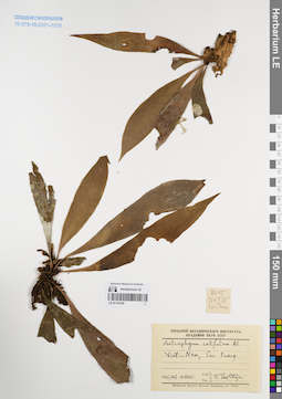
LE 01167234
Antrophyum vittarioides Baker det. Shmakov, Aleksandr Ivanovich at 29.12.2007
Collectors: Tien Hiep Nguyen; Averyanov, Leonid Vladimirovich; The Van Pham Field collecting number: HAL10119. Collection date: 24.11.2006. Administrative regions: VN - Tinh Lai Chau. Groups of specimens: L. V. Averyanov specimens; L. V. Averyanov herbarium; Соглашение Минобрнауки №075-15-2021-1056Original label text:FLORA OF VIETNAM
Poilypodiaceae s.l.
Anthrophium sp.
Lai Chau Prov., Muong Te Distr., Muong Te Municipality, Nam Cum village, around point 22°32′06″N 102°32′29″E.
Epiphytic and lithophytic fern in shady places along water line of the river. Locally common.
HAL 10119 24 Nov. 2006
Coll.: Nguyen Tien Hiep, L.Averyanov, Pham Van The.
Record creation: 2022-01-18, Galina Savich, PhotoScan D2Citation: Specimen LE 01167234 // Virtual herbarium of Komarov Botanical Institute RAS — http://re.herbariumle.ru/01167234Poilypodiaceae s.l.
Anthrophium sp.
Lai Chau Prov., Muong Te Distr., Muong Te Municipality, Nam Cum village, around point 22°32′06″N 102°32′29″E.
Epiphytic and lithophytic fern in shady places along water line of the river. Locally common.
HAL 10119 24 Nov. 2006
Coll.: Nguyen Tien Hiep, L.Averyanov, Pham Van The.
LE 01181050
Groups of specimens: Образцы сектора Восточной Европы; Соглашение Минобрнауки №075-15-2021-1056Record creation: 2022-01-18, Larisa Orlova, PhotoScan D2Citation: Specimen LE 01181050 // Virtual herbarium of Komarov Botanical Institute RAS — http://re.herbariumle.ru/01181050
LE 01167233
Antrophyum superficiale Christ det. Shmakov, Aleksandr Ivanovich at 29.12.2007
Collectors: Averyanov, Leonid Vladimirovich; Nguyen Tien Ban; N.Q. Binh; et al. Field collecting number: VH1356. Collection date: 14.04.1995. Administrative regions: VN - Kon Tum. Groups of specimens: L. V. Averyanov specimens; L. V. Averyanov herbarium; Соглашение Минобрнауки №075-15-2021-1056Original label text:FLORA OF VIETNAM
Polypodiaceae s.l.
Anthrophium sp.
S. Vietnam, Prov. Kontum. Evergreen primary forest along stream
(Dak Mek river system) at 850-900 m alt. on W slope of Ngoc Linh
mountain system abowe Muong Hoong village.
Epiphyte in very shadov place.
VH 1356 14.04.1995
International Botanical Expedition of the U.S.A. National Geographic
Society (grant No 5094-93)
Participants: L. Averyanov, N.T. Ban, N. Q. Binh, A. Budantzev, L. Budantzev, N.T. Hiep, D.D. Huyen, P.K. Loc, N.X. Tam, G. Yakovlev
Record creation: 2022-01-18, Galina Savich, PhotoScan D2Citation: Specimen LE 01167233 // Virtual herbarium of Komarov Botanical Institute RAS — http://re.herbariumle.ru/01167233Polypodiaceae s.l.
Anthrophium sp.
S. Vietnam, Prov. Kontum. Evergreen primary forest along stream
(Dak Mek river system) at 850-900 m alt. on W slope of Ngoc Linh
mountain system abowe Muong Hoong village.
Epiphyte in very shadov place.
VH 1356 14.04.1995
International Botanical Expedition of the U.S.A. National Geographic
Society (grant No 5094-93)
Participants: L. Averyanov, N.T. Ban, N. Q. Binh, A. Budantzev, L. Budantzev, N.T. Hiep, D.D. Huyen, P.K. Loc, N.X. Tam, G. Yakovlev
LE 01181049
Groups of specimens: Образцы сектора Восточной Европы; Соглашение Минобрнауки №075-15-2021-1056Record creation: 2022-01-18, Larisa Orlova, PhotoScan D2Citation: Specimen LE 01181049 // Virtual herbarium of Komarov Botanical Institute RAS — http://re.herbariumle.ru/01181049
LE 01181048
Groups of specimens: Образцы сектора Восточной Европы; Соглашение Минобрнауки №075-15-2021-1056Record creation: 2022-01-18, Larisa Orlova, PhotoScan D2Citation: Specimen LE 01181048 // Virtual herbarium of Komarov Botanical Institute RAS — http://re.herbariumle.ru/01181048
LE 01167232
Phymatosorus lucidus (Roxb.) Pic.Serm. det. Averyanov, Leonid Vladimirovich at 14.03.2002
Collectors: Averyanov, Leonid Vladimirovich; Phan Ke Loc; D.T. Doan Field collecting number: HAL2289. Collection date: 14.03.2002. Administrative regions: VN - Tinh Lao Cai. Groups of specimens: L. V. Averyanov specimens; L. V. Averyanov herbarium; Соглашение Минобрнауки №075-15-2021-1056Original label text:FLORA OF VIETNAM
Polypodiaceae
Phymatosorus lucidus (Roxb.) Pic.Serm.
Northern Vietnam, Lao Cai Prov., Van Ban Distr., Khanh Yen Ha
municipality, elevation from Na Nheo village to the S from 680 to
880 m a.s.l. (around point 21°59′24′'N, 104°16′23′'E). Secondary evergreen broad-leaved wet submontane forest on very steep granite
and quartzite slopes of river canyon. Epiphyte on mossy tree.
Common. Usually associated with Asplenium nidus.
HAL 2289 14 March 2002
Collectors: L.Averyanov, P.K.Loc, D.T.Doan (FFI Project).
Coordinates (geographic position): 21° 59′ 24″ N, 104° 16′ 23″ E ±1000 mRecord creation: 2022-01-18, Galina Savich, PhotoScan D2Citation: Specimen LE 01167232 // Virtual herbarium of Komarov Botanical Institute RAS — http://re.herbariumle.ru/01167232Polypodiaceae
Phymatosorus lucidus (Roxb.) Pic.Serm.
Northern Vietnam, Lao Cai Prov., Van Ban Distr., Khanh Yen Ha
municipality, elevation from Na Nheo village to the S from 680 to
880 m a.s.l. (around point 21°59′24′'N, 104°16′23′'E). Secondary evergreen broad-leaved wet submontane forest on very steep granite
and quartzite slopes of river canyon. Epiphyte on mossy tree.
Common. Usually associated with Asplenium nidus.
HAL 2289 14 March 2002
Collectors: L.Averyanov, P.K.Loc, D.T.Doan (FFI Project).
LE 01181047
Groups of specimens: Образцы сектора Восточной Европы; Соглашение Минобрнауки №075-15-2021-1056Record creation: 2022-01-18, Larisa Orlova, PhotoScan D2Citation: Specimen LE 01181047 // Virtual herbarium of Komarov Botanical Institute RAS — http://re.herbariumle.ru/01181047