View
Add
Copy
Edit
Delete
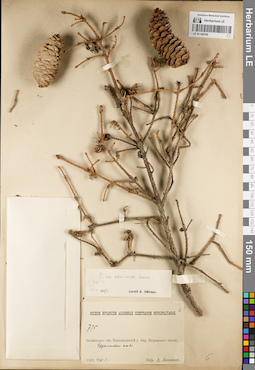
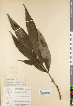
LE 01148769
Picea obovata Ledeb. det. Smirnov, Leonid A. at 14.05.1922
Collectors: Litvinov, Dimitri Ivanovich Field collecting number: 735. Collection date: 01.08.1903. Administrative regions: RU - Zabaykal'skiy Kray. Place of collection: окрестности г. Петровск-Забайкальский (Петровский Завод), Черемховая падь.Groups of specimens: Образцы сектора Сибири и Дальнего Востока России; Соглашение Минобрнауки №075-15-2021-1056Original label text:Museum Botanicum Academiae Scientiarum Petropolitanae. 735. Забайкальск. обл. Верхнеудинский у. Окр. Петровского завода. Черемховая падь. 1903.VIII.1. Собр. Д. Литвинов
Coordinates (geographic position): 51° 16′ 34.87″ N, 108° 51′ 12.88″ E ±60000 mRecord creation: 2022-04-28, Larisa Orlova, PhotoScan D2Citation: Specimen LE 01148769 // Virtual herbarium of Komarov Botanical Institute RAS — http://re.herbariumle.ru/01148769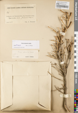
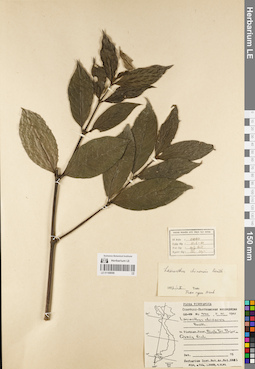
LE 01148768
Picea obovata Ledeb. det. Orlova, Larisa Vladimirovna at 27.04.2022
Additional identifications: Picea obovata Ledeb. det. Smirnov, Leonid A. at 14.05.1922 Collectors: Litvinov, Dimitri Ivanovich Field collecting number: 207. Collection date: 04.06.1903. Administrative regions: RU - Zabaykal'skiy Kray - Petrovsk-Zabaykal'skiy Rayon. Place of collection: окрестности г. Петровск-Забайкальский, Черемховая падь, Умоцкой.Groups of specimens: Образцы сектора Сибири и Дальнего Востока России; Соглашение Минобрнауки №075-15-2021-1056Original label text:Museum Botanicum Academiae Scientiarum Petropolitanae. 207. Забайкальск. обл. Верхнеудинский у. Окр. Петровского завода. Черемховая падь. Умоцкой к[...]. 1903.VI.4. Собр. Д. Литвинов
Coordinates (geographic position): 51° 17′ 14.76″ N, 108° 51′ 39.78″ E ±30000 mRecord creation: 2022-04-28, Larisa Orlova, PhotoScan D2Citation: Specimen LE 01148768 // Virtual herbarium of Komarov Botanical Institute RAS — http://re.herbariumle.ru/01148768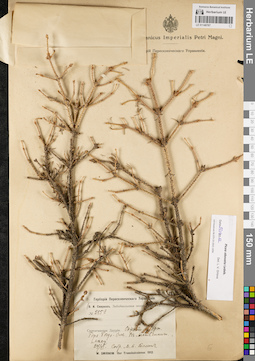
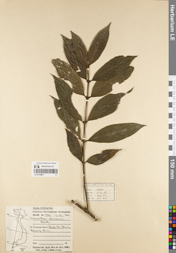
LE 01148767
Picea obovata Ledeb. det. Orlova, Larisa Vladimirovna at 27.04.2022
Collectors: Tomin, Mikhail Petrovich Field collecting number: 255а. Collection date: 24.06.1912. Administrative regions: RU - Respublika Altay - Kosh-Agachskiy Rayon. Place of collection: окрестности р. Урги, гора Таван-Богдо-Ула, лиственничный лес.Expedition: В.И. Смирнов. Забайкальская экспедиция. 1912 (1912)Groups of specimens: Образцы сектора Сибири и Дальнего Востока России; Соглашение Минобрнауки №075-15-2021-1056; Гербарий Переселенческого УправленияOriginal label text:Гербарий Переселенческого Управления. (В.И. Смирнов. Забайкальская экспедиция. 1912.) № 255а. Селенгинская Даурия. Окрест. р. Урги. Гора Богдо-Ола. В лиственничн. лесу. 24/VI. Собр. М.И. Томин. W. Smirnow. Iter Transbaicalense. 1912
Landscape in location of collection: склон горыHabitat / plant community in location of collecting: лиственничный лесCoordinates (geographic position): 49° 10′ 13.73″ N, 87° 48′ 52.09″ E ±10000 mRecord creation: 2022-04-28, Larisa Orlova, PhotoScan D2Citation: Specimen LE 01148767 // Virtual herbarium of Komarov Botanical Institute RAS — http://re.herbariumle.ru/01148767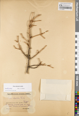
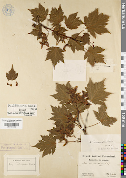
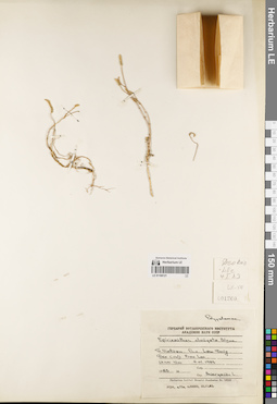
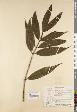
LE 01148766
Picea obovata Ledeb. det. Orlova, Larisa Vladimirovna at 27.04.2022
Additional identifications: Picea obovata Ledeb. det. Kurskiy, P.I. at 1934 Collectors: Kurskiy, P.I. Collection date: 20.08.1934. Administrative regions: RU - Respublika Buryatiya - Zakamenskiy Rayon. Place of collection: бассейн р. Джиды, по обрыву к самой реке от пади Хамней вверх по течению р. Джида.Expedition: Бурято-Монгольская экспедиция ЛОВИУА (1934)Groups of specimens: Образцы сектора Сибири и Дальнего Востока России; Соглашение Минобрнауки №075-15-2021-1056Original label text:Бурято-Монгольская экспедиция ЛОВИУА. Picea obovata Link. Бурято-Монгольская АССР. Бассейн р. Джиды. По обрыву к самой реке от пади Хамней вверх по течению р. Джиды. 20 VIII 1934 г. П.И. Курский
Landscape in location of collection: обрыв к рекеCoordinates (geographic position): 50° 24′ 37.4″ N, 103° 50′ 28.27″ E ±20000 mRecord creation: 2022-04-28, Larisa Orlova, PhotoScan D2Citation: Specimen LE 01148766 // Virtual herbarium of Komarov Botanical Institute RAS — http://re.herbariumle.ru/01148766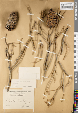
LE 01148765
Picea obovata Ledeb. det. Smirnov, Leonid A. at 13.05.1922
Additional identifications: Picea obovata Ledeb. det. Kryukov, Innokentij Fedorovitch at 1905 Collectors: Kryukov, Innokentij Fedorovitch Field collecting number: 1646. Collection date: 07.08.1905. Administrative regions: RU - Respublika Buryatiya - Barguzinskiy Rayon. Place of collection: берег р. Корча близ Подъикатского зимовья.Expedition: И.Ф. Крюков: Флора Баргузинской тайги Забайкальской области (1905)Groups of specimens: Образцы сектора Сибири и Дальнего Востока России; Соглашение Минобрнауки №075-15-2021-1056Original label text:И. Ф. Крюков: Флора Баргузинской тайги Забайкальской области. Picea obovata. На бер. р. Корчи близ Подъикатского зимовья. 1646. 7.VIII.1905 г.
Landscape in location of collection: берег рекиCoordinates (geographic position): 53° 39′ 49.46″ N, 109° 33′ 21.24″ E ±100000 mRecord creation: 2022-04-28, Larisa Orlova, PhotoScan D2Citation: Specimen LE 01148765 // Virtual herbarium of Komarov Botanical Institute RAS — http://re.herbariumle.ru/01148765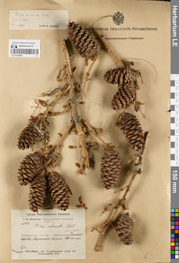
LE 01148764
Picea obovata Ledeb. det. Smirnov, Leonid A. at 13.05.1922
Additional identifications: Picea obovata Ledeb. det. Sukaczev, Vladimir Nikolajevich Collectors: Poplavskaya (Poplawska), Henrietta Ippolitovna Field collecting number: 1808. Collection date: 13.07.1913. Administrative regions: RU - Respublika Buryatiya - Zaigrayevskiy Rayon. Place of collection: Ацагатский Дацан, северо-восточный склон.Expedition: Г.И. Поплавская. Верхнеудинская экспедиция (1913)Groups of specimens: Образцы сектора Сибири и Дальнего Востока России; Соглашение Минобрнауки №075-15-2021-1056; Гербарий Переселенческого УправленияOriginal label text:Museum Botanicum Academiae Scientiarum Petropolitanae. Из гербария Переселенческого Управления. Верхне-Удинская экспедиция Г.И. Поплавской. 1808. Picea obovata Ledb. Teste W. Sukaczew. Забайкальск. обл. Окр. г. Верхнеудинска. Читинский тракт. Ацагатский Дацан. СВ склон. VII.13. H. Poplawska. Iter Transbaicalense prope urb. Verchneudinsk. 1913
Landscape in location of collection: северо-восточный склонCoordinates (geographic position): 52° 1′ 12.27″ N, 108° 16′ 54.71″ E ±5000 mRecord creation: 2022-04-28, Larisa Orlova, PhotoScan D2Citation: Specimen LE 01148764 // Virtual herbarium of Komarov Botanical Institute RAS — http://re.herbariumle.ru/01148764
LE 01148763
Picea obovata Ledeb. det. Ikonnikov-Galitzky, Nikolai Petrovic at 07.06.1940
Collectors: Sukaczev, Vladimir Nikolajevich; Rassadina, Ksenia Alexandrovna; Bryzzhev, Nikolay Alexandrovich Field collecting number: 1671. Collection date: 01.08.1928. Administrative regions: RU - Respublika Buryatiya - Barguzinskiy Rayon. Place of collection: Чивиркуйские гольцы, верховья р. Хырапый.Groups of specimens: Образцы сектора Сибири и Дальнего Востока России; Соглашение Минобрнауки №075-15-2021-1056Original label text:Museum Botanicum Academiae Scientiarum Petropolitanae. 1671. Оз. Байкал. Восточное побережье между 53° и 55° с.ш. Чивиркуйские гольцы. Верховья р. Хырапый.1928.VIII.1. Собр. В.Н. Сукачев, К.А. Рассадина и Н.А. Брызжев
Landscape in location of collection: верховья рекиCoordinates (geographic position): 53° 49′ 23.42″ N, 109° 13′ 26.92″ E ±50000 mRecord creation: 2022-04-28, Larisa Orlova, PhotoScan D2Citation: Specimen LE 01148763 // Virtual herbarium of Komarov Botanical Institute RAS — http://re.herbariumle.ru/01148763
LE 01148762
Picea obovata Ledeb. det. Smirnov, Leonid A. at 14.05.1922
Additional identifications: Picea obovata Ledeb. det. Sukaczev, Vladimir Nikolajevich Collectors: Poplavskaya (Poplawska), Henrietta Ippolitovna; Poplavsky, M. I.; Ditmer, Erna E. Field collecting number: 2578. Collection date: 14.08.1913. Administrative regions: RU - Zabaykal'skiy Kray - Borzinskiy Rayon. Place of collection: окрестности почновой станции Золотухино, пос. Тасырхой, щебенчатый степной склон.Expedition: Г.И. Поплавская. Верхнеудинская экспедиция (1913)Groups of specimens: Образцы сектора Сибири и Дальнего Востока России; Соглашение Минобрнауки №075-15-2021-1056; Гербарий Переселенческого УправленияOriginal label text:Museum Botanicum Academiae Scientiarum Petropolitanae. Из гербария Переселенческого Управления. Верхне-Удинская экспедиция Г.И. Поплавской. 2578. Picea obovata Ldb. Teste W. Sukaszew. Забайкальск. обл. Верхнеудин. у. Читинский тракт. Окр. почт. ст. Золотухино. Падь Тасархой. Шусывей, щебенчатый, степной склон. 1913.VIII.14. Г. Поплавская, М. Поплавский и Э. Дитмер
Landscape in location of collection: щебенчатый степной склонCoordinates (geographic position): 50° 24′ 19.75″ N, 116° 6′ 26.04″ E ±5000 mRecord creation: 2022-04-28, Larisa Orlova, PhotoScan D2Citation: Specimen LE 01148762 // Virtual herbarium of Komarov Botanical Institute RAS — http://re.herbariumle.ru/01148762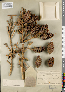
LE 01148761
Picea obovata Ledeb. det. Smirnov, Leonid A. at 14.05.1922
Additional identifications: Picea obovata Ledeb. det. Sukaczev, Vladimir Nikolajevich Collectors: Poplavskaya (Poplawska), Henrietta Ippolitovna; Poplavsky, M. I.; Ditmer, Erna E. Field collecting number: 1808. Collection date: 13.07.1913. Administrative regions: RU - Respublika Buryatiya - Zaigrayevskiy Rayon. Place of collection: Ацагатский Дацан, северный склон.Expedition: Г.И. Поплавская. Верхнеудинская экспедиция (1913)Groups of specimens: Образцы сектора Сибири и Дальнего Востока России; Соглашение Минобрнауки №075-15-2021-1056; Гербарий Переселенческого УправленияOriginal label text:Museum Botanicum Academiae Scientiarum Petropolitanae. Из гербария Переселенческого Управления. Верхне-Удинская экспедиция Г.И. Поплавской. 1808. Picea obovata Ledb. Teste W. Sukaczew. Забайкальск. обл. Читинский тракт. Ацагатский Дацан. Сев. склон. 1913.VII.13. Г. Поплавская, М. Поплавский и Э. Дитмер
Landscape in location of collection: северный склонCoordinates (geographic position): 52° 1′ 1.1″ N, 108° 15′ 43.66″ E ±5000 mRecord creation: 2022-04-28, Larisa Orlova, PhotoScan D2Citation: Specimen LE 01148761 // Virtual herbarium of Komarov Botanical Institute RAS — http://re.herbariumle.ru/01148761
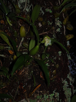
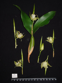
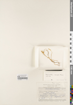
LE 01168126
Cymbidium erythrostylum Rolfe det. Averyanov, Leonid Vladimirovich at 14.04.2022
Collectors: Dobrydneva, Anastasia; Maisak, Tatiana Viktorovna; Averyanov, Leonid Vladimirovich Field collecting number: Averyanov s.n.. Collection date: 14.04.2022. Administrative regions: VN - Vietnam. Groups of specimens: L. V. Averyanov specimens; L. V. Averyanov herbariumOriginal label text:FLORA OF VIETNAM
Record creation: 2022-04-28, Tatiana Maisak, PhotoScan D2. Processing status: work_status_1Citation: Specimen LE 01168126 // Virtual herbarium of Komarov Botanical Institute RAS — http://re.herbariumle.ru/01168126Orchidaceae
Cymbidium erythrostylum Rolfe
Southern Vietnam, sine loc., sine date, sine coll., wild collected cultivated plant, herbarium prepared in 14.04.2022, A. Dobrydneva, T. Maisak, L. Averyanov s.n.
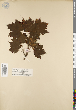
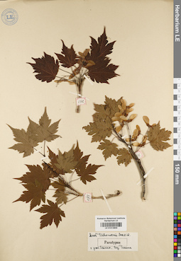
LE 01168125
Isotype of Impatiens namdongensis C.H.Nguyen & Aver. det. Cuong, Huu Nguyen at 29.06.2019
Collectors: N.H. Cuong; N.V. Ly; L.V. Luc Field collecting number: CLL 490. Collection date: 29.06.2019. Administrative regions: VN - Tinh Thanh Hoa. Groups of specimens: L. V. Averyanov specimens; L. V. Averyanov herbarium; Соглашение Минобрнауки №075-15-2021-1056Original label text:FLORA OF VIETNAM
Record creation: 2022-04-28, Tatiana Maisak, PhotoScan D2. Processing status: work_status_1Citation: Specimen LE 01168125 // Virtual herbarium of Komarov Botanical Institute RAS — http://re.herbariumle.ru/01168125Balsaminaceae
Impatiens namdongensis C.H.Nguyen & Aver.
Thanh Hoa Province, Quan Hoa Distr.
29 June 2019, N.H.Cuong et al., CLL 490

LE 01058763
Anisopappus chinensis (L.) Hook. & Arn. det. Sennikov, Alexander Nikolaevitsch at 08.05.2022
Additional identifications: Anthemis sp. ⟮prelim. ID⟯ det. Averyanov, Leonid Vladimirovich at 29.10.2019 Collectors: Averyanov, Leonid Vladimirovich; Nguyen Van Canh; Maisak, Tatiana Viktorovna Field collecting number: AL1226. Collection date: 29.10.2019. Administrative regions: VN - Tinh Lam GJong; VN - Tinh Khanh Hoa. Groups of specimens: L. V. Averyanov specimens; L. V. Averyanov herbarium; Соглашение Минобрнауки №075-15-2021-1056Original label text:FLORA OF VIETNAM
Record creation: 2022-04-28, Tatiana Maisak, PhotoScan D2. Processing status: work_status_1Citation: Specimen LE 01058763 // Virtual herbarium of Komarov Botanical Institute RAS — http://re.herbariumle.ru/01058763Asteraceae
Anthemis sp.?
The border of Lam Dong and Khanh Hoa Provinces, Khanh Le Pass (Hon Giao Pass) area, open secondary grassy coniferous forest and woodlands (with Pinus kesiya) on granite hills at elev. 1400-1500 m a.s.l. Erect terrestrial herb to 0.5 m tall in open places. Flowers bright yellow. Common. 29 October 2019, L. Averyanov, Nguyen Van Canh, T. Maisak, AL 1226.
LE 01123085
Cymbidium nanulum Y.S.Wu & S.C.Chen det. Averyanov, Leonid Vladimirovich at 26.04.2022
Collectors: Averyanov, Leonid Vladimirovich; Maisak, Tatiana Viktorovna Field collecting number: Nguyen Hoang Tuan s.n.. Collection date: 26.04.2022. Administrative regions: VN - Tinh GJak Lak. Groups of specimens: L. V. Averyanov specimens; L. V. Averyanov photos; Orchids of Vietnam, Laos and CambodiaOriginal label text:FLORA OF VIETNAM
Orchidaceae
Cymbidium nanulum Y.S.Wu & S.C.Chen
Dak Lak province, Ea H'leo district and Dak Nong province, Dak Mil district, lip oblong-ovate, not fused to basal margins of column, obscurely 3-lobed. In the midst of the evergreen forest, along the stream in Dipterocarp forests. Flowering in May–June. 1 May 2018, Nguyen Hoang Tuan, Nguyen Van Canh, s.n.
Herbarium and photos prepared in 26 April 2022, L. Averyanov, T. Maisak
All photos © - L. Averyanov
LE 01123086
Eparmatostigma dives (Rchb.f.) Garay det. Averyanov, Leonid Vladimirovich at 26.04.2022
Collectors: Averyanov, Leonid Vladimirovich; Maisak, Tatiana Viktorovna Field collecting number: K-224. Collection date: 26.04.2022. Administrative regions: LA - Khammouan. Groups of specimens: L. V. Averyanov specimens; L. V. Averyanov photos; Orchids of Vietnam, Laos and CambodiaOriginal label text:FLORA OF LAOS
Coordinates (geographic position): 18° 13′ 1.62″ N, 104° 56′ 33.06″ E ±1000 mComment: Orchidaceae
Eparmatostigma dives (Rchb.f.) Garay
Laos, Khammouane prov., Laksao. Северо-восточный склон известнякового останца. 637 м над ур. м., 18°13.027N 104°56.551E. Е.Константинов K 224. Гербарный сбор/фото 31.10.2013.
Herbarium prepared in 26.04.2022, flowers odorless, white to very light yellowish. L. Averyanov K-224.
All photos © - L. Averyanov
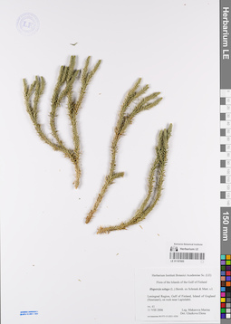
LE 01187805
Huperzia selago (L.) Bernh. ex Schrank & Mart. det. Glazkova, Elena Aleksandrovna at 2022
Collectors: Smirnova (Makarova), Marina Alexeevna Collection date: 11.08.2006. Administrative regions: RU - Leningradskaya Oblast' - Kingiseppskiy Rayon. Groups of specimens: Образцы сектора Восточной Европы; Соглашение Минобрнауки №075-15-2021-1056Original label text:Leningrad Region, gulf of Finland, island of Gogland (Suursaari), on rock near Lapinlahti
Record creation: 2022-04-27, Marina Yarichina, PhotoScan D2Citation: Specimen LE 01187805 // Virtual herbarium of Komarov Botanical Institute RAS — http://re.herbariumle.ru/01187805
LE 01187804
Huperzia selago (L.) Bernh. ex Schrank & Mart. det. Glazkova, Elena Aleksandrovna at 2022
Collectors: Smirnova (Makarova), Marina Alexeevna Collection date: 07.08.2006. Administrative regions: RU - Leningradskaya Oblast' - Kingiseppskiy Rayon. Groups of specimens: Образцы сектора Восточной Европы; Соглашение Минобрнауки №075-15-2021-1056Original label text:Leningrad Region, gulf of Finland, island of Gogland (Suursaari), in gorge between rocks
Record creation: 2022-04-27, Marina Yarichina, PhotoScan D2Citation: Specimen LE 01187804 // Virtual herbarium of Komarov Botanical Institute RAS — http://re.herbariumle.ru/01187804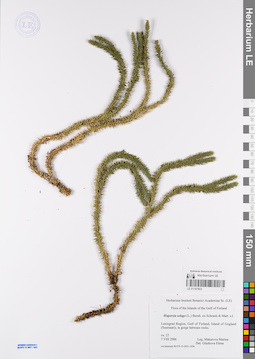
LE 01187803
Huperzia selago (L.) Bernh. ex Schrank & Mart. det. Glazkova, Elena Aleksandrovna at 2022
Collectors: Smirnova (Makarova), Marina Alexeevna Collection date: 07.08.2006. Administrative regions: RU - Leningradskaya Oblast' - Kingiseppskiy Rayon. Groups of specimens: Образцы сектора Восточной Европы; Соглашение Минобрнауки №075-15-2021-1056Original label text:Leningrad Region, gulf of Finland, island of Gogland (Suursaari), on gorge berween rocks.
Record creation: 2022-04-27, Marina Yarichina, PhotoScan D2Citation: Specimen LE 01187803 // Virtual herbarium of Komarov Botanical Institute RAS — http://re.herbariumle.ru/01187803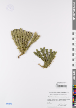
LE 01187802
Huperzia selago (L.) Bernh. ex Schrank & Mart. det. Glazkova, Elena Aleksandrovna at 2022
Collectors: Smirnova (Makarova), Marina Alexeevna Collection date: 07.08.2006. Administrative regions: RU - Leningradskaya Oblast' - Kingiseppskiy Rayon. Groups of specimens: Образцы сектора Восточной Европы; Соглашение Минобрнауки №075-15-2021-1056Original label text:Leningrad Region, gulf of Finland, island of Gogland (Suursaari), on rock near a path to Lettolahti.
Record creation: 2022-04-27, Marina Yarichina, PhotoScan D2Citation: Specimen LE 01187802 // Virtual herbarium of Komarov Botanical Institute RAS — http://re.herbariumle.ru/01187802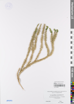
LE 01187800
Lycopodium annotinum L. det. Zueva A. S.
Collectors: Zueva A. S. Collection date: 25.06.2020. Administrative regions: RU - Leningradskaya Oblast' - Kingiseppskiy Rayon. Groups of specimens: Образцы сектора Восточной Европы; Соглашение Минобрнауки №075-15-2021-1056Original label text:Ленинградская область, о. Гогланд, г. Notkonkallio
Record creation: 2022-04-27, Marina Yarichina, PhotoScan D2Citation: Specimen LE 01187800 // Virtual herbarium of Komarov Botanical Institute RAS — http://re.herbariumle.ru/01187800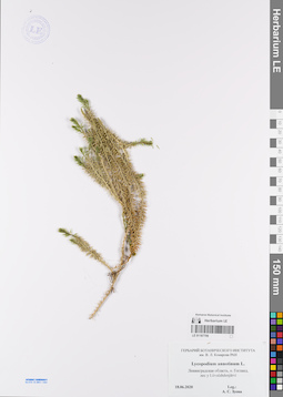
LE 01187799
Lycopodium annotinum L. det. Zueva A. S.
Collectors: Zueva A. S. Collection date: 18.06.2020. Administrative regions: RU - Leningradskaya Oblast' - Kingiseppskiy Rayon. Groups of specimens: Образцы сектора Восточной Европы; Соглашение Минобрнауки №075-15-2021-1056Original label text:Ленинградская область, о. Гогланд, лес у Liivalahdenjärvi
Record creation: 2022-04-27, Marina Yarichina, PhotoScan D2Citation: Specimen LE 01187799 // Virtual herbarium of Komarov Botanical Institute RAS — http://re.herbariumle.ru/01187799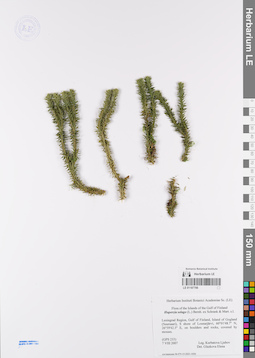
LE 01187798
Huperzia selago (L.) Bernh. ex Schrank & Mart. det. Glazkova, Elena Aleksandrovna at 2022
Collectors: Kurbatova, L. E. Collection date: 07.08.2007. Administrative regions: RU - Leningradskaya Oblast' - Kingiseppskiy Rayon. Groups of specimens: Образцы сектора Восточной Европы; Соглашение Минобрнауки №075-15-2021-1056Original label text:Leningrad Region, gulf of Finland, island of Gogland (Suursaari), S shore of Lounarjärvi, 60°01'48.7" N, 26°59'42.5" E, on boulders and rocks, covered by mosses.
Coordinates (geographic position): 60° 1′ 48.7″ N, 26° 59′ 42.5″ ERecord creation: 2022-04-27, Marina Yarichina, PhotoScan D2Citation: Specimen LE 01187798 // Virtual herbarium of Komarov Botanical Institute RAS — http://re.herbariumle.ru/01187798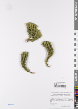
LE 01187797
Huperzia selago (L.) Bernh. ex Schrank & Mart. det. Glazkova, Elena Aleksandrovna at 2022
Collectors: Kurbatova, L. E. Collection date: 11.08.2007. Administrative regions: RU - Leningradskaya Oblast' - Kingiseppskiy Rayon. Groups of specimens: Образцы сектора Восточной Европы; Соглашение Минобрнауки №075-15-2021-1056Original label text:Leningrad Region, gulf of Finland, island of Gogland (Suursaari), Ruokolahdenjärvi (оз. Купальное), 60°02'37.5" N, 26°59'24.2" E, rock on SW shore of the lake.
Coordinates (geographic position): 60° 2′ 37.5″ N, 26° 59′ 24.2″ ERecord creation: 2022-04-27, Marina Yarichina, PhotoScan D2Citation: Specimen LE 01187797 // Virtual herbarium of Komarov Botanical Institute RAS — http://re.herbariumle.ru/01187797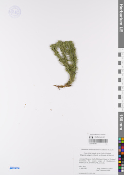
LE 01187796
Huperzia selago (L.) Bernh. ex Schrank & Mart. det. Glazkova, Elena Aleksandrovna at 2022
Collectors: Kurbatova, L. E. Collection date: 18.08.2007. Administrative regions: RU - Leningradskaya Oblast' - Kingiseppskiy Rayon. Groups of specimens: Образцы сектора Восточной Европы; Соглашение Минобрнауки №075-15-2021-1056Original label text:Leningrad Region, gulf of Finland, island of Gogland (Suursaari), the eastern slope of Haukkavuori, 60°04'12.5" N, 26°58'39.2" E, on rocks.
Coordinates (geographic position): 60° 4′ 12.5″ N, 26° 58′ 39.2″ ERecord creation: 2022-04-27, Marina Yarichina, PhotoScan D2Citation: Specimen LE 01187796 // Virtual herbarium of Komarov Botanical Institute RAS — http://re.herbariumle.ru/01187796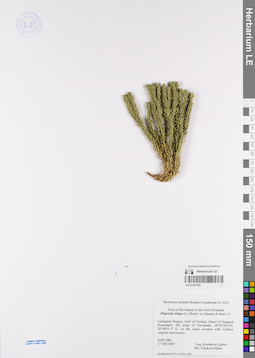
LE 01187795
Huperzia selago (L.) Bernh. ex Schrank & Mart. det. Glazkova, Elena Aleksandrovna at 2022
Collectors: Kurbatova, L. E. Collection date: 17.08.2007. Administrative regions: RU - Leningradskaya Oblast' - Kingiseppskiy Rayon. Groups of specimens: Образцы сектора Восточной Европы; Соглашение Минобрнауки №075-15-2021-1056Original label text:Leningrad Region, gulf of Finland, island of Gogland (Suursaari), NE slope of Tervämäki, 60°03'38.5" N, 26°58'55.5" E, on the rocks covered with Colluna vulgaris ans mosses.
Coordinates (geographic position): 60° 3′ 38.5″ N, 26° 58′ 55.5″ ERecord creation: 2022-04-27, Marina Yarichina, PhotoScan D2Citation: Specimen LE 01187795 // Virtual herbarium of Komarov Botanical Institute RAS — http://re.herbariumle.ru/01187795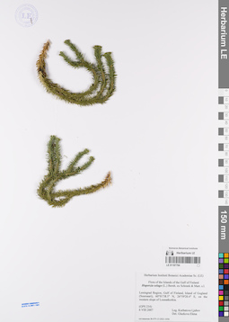
LE 01187794
Huperzia selago (L.) Bernh. ex Schrank & Mart. det. Glazkova, Elena Aleksandrovna at 2022
Collectors: Kurbatova, L. E. Collection date: 06.08.2007. Administrative regions: RU - Leningradskaya Oblast' - Kingiseppskiy Rayon. Groups of specimens: Образцы сектора Восточной Европы; Соглашение Минобрнауки №075-15-2021-1056Original label text:Leningrad Region, gulf of Finland, island of Gogland (Suursaari), a small gorge on the NE slope of Tervämäki, 60°01'38.5" N, 26°59'20.4" E, on the western slope of Lounatkorkia.
Coordinates (geographic position): 60° 1′ 38.5″ N, 26° 59′ 20.4″ ERecord creation: 2022-04-27, Marina Yarichina, PhotoScan D2Citation: Specimen LE 01187794 // Virtual herbarium of Komarov Botanical Institute RAS — http://re.herbariumle.ru/01187794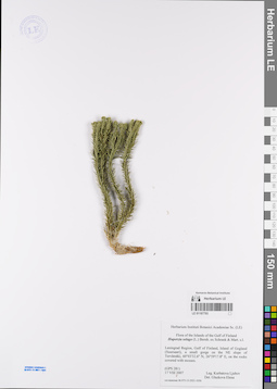
LE 01187793
Huperzia selago (L.) Bernh. ex Schrank & Mart. det. Glazkova, Elena Aleksandrovna at 2022
Collectors: Kurbatova, L. E. Collection date: 17.08.2007. Administrative regions: RU - Leningradskaya Oblast' - Kingiseppskiy Rayon. Groups of specimens: Образцы сектора Восточной Европы; Соглашение Минобрнауки №075-15-2021-1056Original label text:Leningrad Region, gulf of Finland, island of Gogland (Suursaari), a small gorge on the NE slope of Tervämäki, 60°03'32.6" N, 26°59'17.8" E, on the rocks covered with moss.
Coordinates (geographic position): 60° 3′ 32.6″ N, 26° 59′ 17.8″ ERecord creation: 2022-04-27, Marina Yarichina, PhotoScan D2Citation: Specimen LE 01187793 // Virtual herbarium of Komarov Botanical Institute RAS — http://re.herbariumle.ru/01187793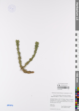
LE 01187792
Huperzia selago (L.) Bernh. ex Schrank & Mart. det. Glazkova, Elena Aleksandrovna at 2022
Collectors: Kurbatova, L. E. Collection date: 06.08.2007. Administrative regions: RU - Leningradskaya Oblast' - Kingiseppskiy Rayon. Groups of specimens: Образцы сектора Восточной Европы; Соглашение Минобрнауки №075-15-2021-1056Original label text:Leningrad Region, gulf of Finland, island of Gogland (Suursaari), in vacinity of Lounarjarvi, 60°01'51.8" N, 26°59'27.4" E, in pine-spruce-birch forest of Vaccinium myrtillus-green moss type.
Coordinates (geographic position): 60° 1′ 51.8″ N, 26° 59′ 27.4″ ERecord creation: 2022-04-27, Marina Yarichina, PhotoScan D2Citation: Specimen LE 01187792 // Virtual herbarium of Komarov Botanical Institute RAS — http://re.herbariumle.ru/01187792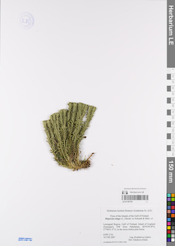
LE 01187791
Huperzia selago (L.) Bernh. ex Schrank & Mart. det. Glazkova, Elena Aleksandrovna at 2022
Collectors: Kurbatova, L. E. Collection date: 16.08.2007. Administrative regions: RU - Leningradskaya Oblast' - Kingiseppskiy Rayon. Groups of specimens: Образцы сектора Восточной Европы; Соглашение Минобрнауки №075-15-2021-1056Original label text:Leningrad Region, gulf of Finland, island of Gogland (Suursaari), NW from Pahalampi, 60°02'05.8" N, 27° 00'21.4" E, in moss-lichen pine forest
Coordinates (geographic position): 60° 2′ 5.8″ N, 27° 0′ 21.4″ ERecord creation: 2022-04-27, Marina Yarichina, PhotoScan D2Citation: Specimen LE 01187791 // Virtual herbarium of Komarov Botanical Institute RAS — http://re.herbariumle.ru/01187791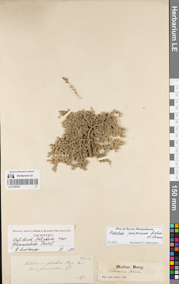
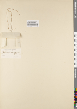
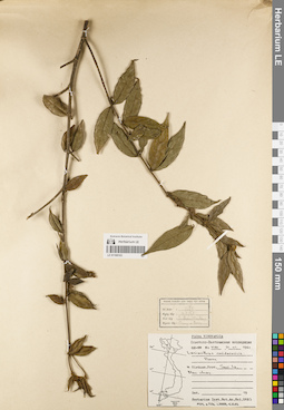
LE 01082540
Salicornia foliata Pall.
Collectors: Bunge, Alexander Andrejewitsch von Collection date: 1839. Administrative regions: RU - Altayskiy Kray. Groups of specimens: Типовые образцы сектора Сибири и Дальнего Востока РоссииOriginal label text:Flor. orient. altaica
Record creation: 2022-04-26, Марина Витальевна ЯричинаCitation: Specimen LE 01082540 // Virtual herbarium of Komarov Botanical Institute RAS — http://re.herbariumle.ru/01082540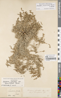
LE 01082539
Salicornia foliata Pall. det. Ledebour, Carl (Karl) Friedrich von [Ledebour]
Collectors: Ledebour, Carl (Karl) Friedrich von [Ledebour] Collection date: 1826. Administrative regions: RU - Altayskiy Kray. Groups of specimens: Типовые образцы сектора Сибири и Дальнего Востока РоссииOriginal label text:Altai
Record creation: 2022-04-26, Марина Витальевна ЯричинаCitation: Specimen LE 01082539 // Virtual herbarium of Komarov Botanical Institute RAS — http://re.herbariumle.ru/01082539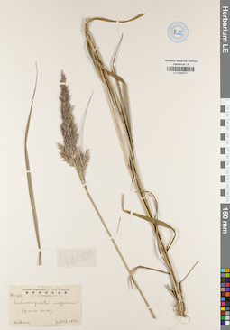
LE 01042711
Record creation: 2022-04-25, Daria Yudova, PhotoScan D2Citation: Specimen LE 01042711 // Virtual herbarium of Komarov Botanical Institute RAS — http://re.herbariumle.ru/01042711
LE 01013901
Record creation: 2022-04-25, Daria Yudova, PhotoScan D2Citation: Specimen LE 01013901 // Virtual herbarium of Komarov Botanical Institute RAS — http://re.herbariumle.ru/01013901
LE 01013800
Record creation: 2022-04-25, Daria Yudova, PhotoScan D2Citation: Specimen LE 01013800 // Virtual herbarium of Komarov Botanical Institute RAS — http://re.herbariumle.ru/01013800
LE 01013799
Record creation: 2022-04-25, Daria Yudova, PhotoScan D2Citation: Specimen LE 01013799 // Virtual herbarium of Komarov Botanical Institute RAS — http://re.herbariumle.ru/01013799
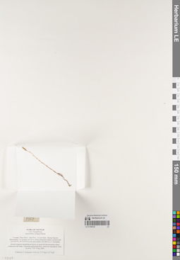
LE 01168124
Epirixanthes elongata Blume det. Korthals Pieter Willem
Collectors: Korthals Pieter Willem Field collecting number: Korthals s.n.. Administrative regions: ID - Provinsi Sumatera Barat. Groups of specimens: L. V. Averyanov specimens; L. V. Averyanov herbarium; Соглашение Минобрнауки №075-15-2021-1056Original label text:Communicat. ex Herbario Lugduno-Batavo.
Record creation: 2022-04-22, Galina Savich, PhotoScan D2. Processing status: work_status_1Citation: Specimen LE 01168124 // Virtual herbarium of Komarov Botanical Institute RAS — http://re.herbariumle.ru/01168124Epirixanthes elongata Bl.
Sumatra.
Legit Korthals.
LE 01168123
Epirixanthes elongata Blume det. Averyanov, Leonid Vladimirovich at 1991
Collectors: Averyanov, Leonid Vladimirovich; et al. Field collecting number: LX-VN 1719. Collection date: 18.04.1984. Administrative regions: VN - Tinh Lam GJong. Groups of specimens: L. V. Averyanov specimens; L. V. Averyanov herbarium; Соглашение Минобрнауки №075-15-2021-1056Original label text:FLORA OF VIETNAM
Record creation: 2022-04-22, Galina Savich, PhotoScan D2. Processing status: work_status_1Citation: Specimen LE 01168123 // Virtual herbarium of Komarov Botanical Institute RAS — http://re.herbariumle.ru/01168123Russian - Vietnamese Expedition
Polygalaceae
Epirixanthes elongata Blume
Lam Dong, Blao, Bao Loc. Forest. Tepals white. 18 April 1984. LX-VN 1719. L. Averyanov et al.
LE 01168122
Epirixanthes elongata Blume det. Averyanov, Leonid Vladimirovich at 03.05.2005
Collectors: Averyanov, Leonid Vladimirovich; et al. Field collecting number: HAL7757. Collection date: 03.05.2005. Administrative regions: VN - Tinh Thua Thien-Hue. Groups of specimens: L. V. Averyanov specimens; L. V. Averyanov herbarium; Соглашение Минобрнауки №075-15-2021-1056Original label text:FLORA OF VIETNAM
Fam. Polygalaceae
Epirixanthes elongata Blume
Vietnam, Thua Thien – Hue Prov., A Luoi Distr., Huong Nguyen Municipality, in vicinities of Tra Ve forest protection station, around point 16°13'47''N, 107°27'47''E at elevation about 120-300 m a.s.l. Secondary closed evergreen broad-leaved forest on steep hill and mountain slopes composed with shale. Terrestrial achlorophyllous yellowish saprophyte. Rare.
No HAL 7757 3 May 2005.
Collectors: L.Averyanov, P.K.Loc, T.V.Thao, N.T.Vinh.
LE 01168121
Epirixanthes elongata Blume det. Averyanov, Leonid Vladimirovich at 04.01.1983
Collectors: Yakovlev, Gennady Pavlovich; et al. Field collecting number: LX-VN 1200. Collection date: 04.01.1983. Administrative regions: VN - Tinh Lam GJong. Groups of specimens: L. V. Averyanov specimens; L. V. Averyanov herbarium; Соглашение Минобрнауки №075-15-2021-1056Original label text:FLORA OF VIETNAM
Record creation: 2022-04-22, Galina Savich, PhotoScan D2. Processing status: work_status_1Citation: Specimen LE 01168121 // Virtual herbarium of Komarov Botanical Institute RAS — http://re.herbariumle.ru/01168121Russian - Vietnamese Expedition
Polygalaceae
Epirixanthes elongata Blume
S Vietnam, Prov. Lam Dong, Deo (col) Bao Loc. LX-VN 1200 4.01.1983. G. Yakovlev et al.
Det. Averyanov L. 1983
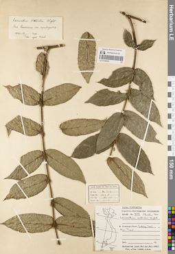
LE 01168107
Lasianthus condorensis Picrre det. Busch at 21.01.1961
Collectors: Busch Field collecting number: 1581. Collection date: 21.01.1961. Administrative regions: VN - Tinh Son La. Groups of specimens: L. V. Averyanov specimens; L. V. Averyanov herbarium; Соглашение Минобрнауки №075-15-2021-1056Original label text:FLORA OF VIETNAM
Rubiaceae
Lasianthus condorensis Picrre
N Vietnam, Son La, Moc Chau
21.01.1961 № 1581
LE 01168106
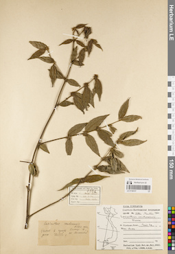
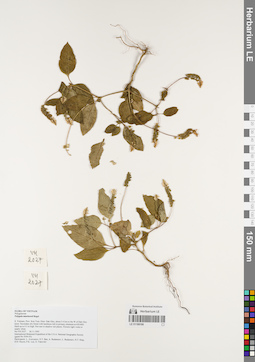
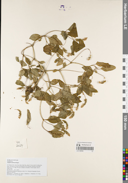
Polygala umbonata Craib ⟨Fl. CLV 2014⟩ det. Colin Pendry
Additional identifications: Polygala tatarinowii Regel det. Averyanov, Leonid Vladimirovich at 26.11.1995 Collectors: Averyanov, Leonid Vladimirovich; et al. Field collecting number: VH2027. Collection date: 26.11.1995. Administrative regions: VN - Kon Tum. Groups of specimens: L. V. Averyanov specimens; L. V. Averyanov herbarium; Соглашение Минобрнауки №075-15-2021-1056Original label text:FLORA OF VIETNAM
Fam. Polygalaceae
Polygala sp.
S. Vietnam, Prov. Kon Tum, Distr. Dak Gley, about 3-4 km to the W of Dak Gley town. Secondary dry forest with bamboos rich in primary elements at 650-800. Herb up to 0.3 m high. Not rare in shadow wet places. Flowers light violet or nearly white.
No VH 2027 26.11.1995
International Botanical Expedition of the U.S.A. National Geographic Society (grant No 5094-93)
Participants: L. Averyanov, N.T. Ban, A. Budantzev, L. Budantzev, N.T. Hiep, D.D. Huyen, P.K. Loc, G. Yakovlev
LE 01168105
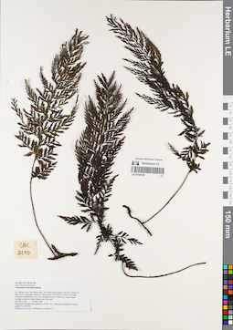
Trichomanes maximum Blume det. Averyanov, Leonid Vladimirovich at 03.05.1999
Collectors: Phan Ke Loc; P.H. Hoang; Averyanov, Leonid Vladimirovich Field collecting number: CBL2100. Collection date: 03.05.1999. Administrative regions: VN - Tinh Ha Giang. Groups of specimens: L. V. Averyanov specimens; L. V. Averyanov herbarium; Соглашение Минобрнауки №075-15-2021-1056Original label text:FLORA OF VIETNAM
Fam. Hymenophyllaceae
Trichomanes sp.
N. Vietnam, prov. Ha Giang, distr. Yen Minh, municipality Du Gia, E slopes of Phu Tha Ca mountain system at 1500 m elev. (N 23ш56' E 105ш13'). Primary evergreen broadleaved very wet mountain forest on shale very steep slopes. Lithophyte fern on shady shale rocks. Not rare.
No CBL 2100 03 May 1999
International Botanical Expedition of the U.S.A. National Geographic Society (grant No 6300-98)
Collectors: P.K.Loc, P.H.Hoang, Averyanov L.
LE 01168104
Polygala umbonata Craib ⟨Fl. CLV 2014⟩ det. Colin Pendry
Additional identifications: Polygala tatarinowii Regel det. Averyanov, Leonid Vladimirovich at 26.11.1995 Collectors: Averyanov, Leonid Vladimirovich; et al. Field collecting number: VH2027. Collection date: 26.11.1995. Administrative regions: VN - Kon Tum. Groups of specimens: L. V. Averyanov specimens; L. V. Averyanov herbarium; Соглашение Минобрнауки №075-15-2021-1056Original label text:FLORA OF VIETNAM
Fam. Polygalaceae
Polygala sp.
S. Vietnam, Prov. Kon Tum, Distr. Dak Gley, about 3-4 km to the W of Dak Gley town. Secondary dry forest with bamboos rich in primary elements at 650-800. Herb up to 0.3 m high. Not rare in shadow wet places. Flowers light violet or nearly white.
No VH 2027 26.11.1995
International Botanical Expedition of the U.S.A. National Geographic Society (grant No 5094-93)
Participants: L. Averyanov, N.T. Ban, A. Budantzev, L. Budantzev, N.T. Hiep, D.D. Huyen, P.K. Loc, G. Yakovlev
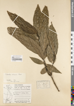
LE 01168103
Lasianthus condorensis Picrre det. Busch at 21.01.1961
Collectors: Busch Field collecting number: 1581. Collection date: 21.01.1961. Administrative regions: VN - Tinh Son La. Groups of specimens: L. V. Averyanov specimens; L. V. Averyanov herbarium; Соглашение Минобрнауки №075-15-2021-1056Original label text:FLORA OF VIETNAM
Rubiaceae
Lasianthus condorensis Picrre
N Vietnam, Son La, Moc Chau.
21.01.1961 № 1581
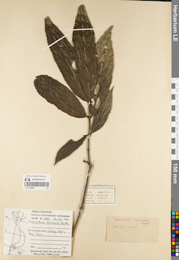
LE 01168102
Lasianthus wallichii Wight det. Busch at 28.04.1961
Collectors: Busch Field collecting number: 1479. Collection date: 28.04.1961. Administrative regions: VN - Tinh Lang Son. Groups of specimens: L. V. Averyanov specimens; L. V. Averyanov herbarium; Соглашение Минобрнауки №075-15-2021-1056Original label text:FLORA OF VIETNAM
Rubiaceae
Lasianthus wallichii Wight
N Vietnam, Lang Son, Nui Tieu
28.04.1961 № 1479
LE 01168101
Lasianthus chinensis Benth. det. Busch at 28.04.1961
Collectors: Busch Field collecting number: 1489. Collection date: 28.04.1961. Administrative regions: VN - Tinh Lang Son. Groups of specimens: L. V. Averyanov specimens; L. V. Averyanov herbarium; Соглашение Минобрнауки №075-15-2021-1056Original label text:FLORA OF VIETNAM
Rubiaceae
Lasianthus chinensis Benth
N Vietnam, Lang Son, Nui Tieu
28.04.1961 № 1489
LE 01168100
Lasianthus chinensis Benth. det. Busch at 28.04.1961
Collectors: Busch Field collecting number: 1489. Collection date: 28.04.1961. Administrative regions: VN - Tinh Lang Son. Groups of specimens: L. V. Averyanov specimens; L. V. Averyanov herbarium; Соглашение Минобрнауки №075-15-2021-1056Original label text:FLORA OF VIETNAM
Rubiaceae
Lasianthus chinensis Benth
N Vietnam, Lang Son, Nui Tieu
28.04.1961 № 1489
LE 01168099
Lasianthus chinensis Benth. det. Busch at 27.10.1960
Collectors: Takhtajan, Armen Leonovich Field collecting number: 609. Collection date: 27.10.1960. Administrative regions: VN - Vietnam. Groups of specimens: L. V. Averyanov specimens; L. V. Averyanov herbarium; Соглашение Минобрнауки №075-15-2021-1056Original label text:FLORA OF VIETNAM
Rubiaceae
Lasianthus chinensis Benth
N Vietnam, Prov. ...
27.10.1960 № 609
LE 01168098
Lasianthus chinensis Benth. det. Busch at 11.01.1961
Collectors: Busch Field collecting number: 990. Collection date: 11.01.1961. Administrative regions: VN - Tinh Quang Binh. Groups of specimens: L. V. Averyanov specimens; L. V. Averyanov herbarium; Соглашение Минобрнауки №075-15-2021-1056Original label text:FLORA OF VIETNAM
Rubiaceae
Lasianthus chinensis Benth
N Vietnam, Binh Tri Thien, Quang Binh
11.01.1961 № 990
LE 01168097
Lasianthus chinensis Benth. det. Busch at 11.01.1961
Collectors: Busch Field collecting number: 990. Collection date: 11.01.1961. Administrative regions: VN - Tinh Quang Binh. Groups of specimens: L. V. Averyanov specimens; L. V. Averyanov herbarium; Соглашение Минобрнауки №075-15-2021-1056Original label text:FLORA OF VIETNAM
Rubiaceae
Lasianthus chinensis Benth
N Vietnam, Binh Tri Thien, Quang Binh.
11.01.1961 № 990
LE 01168096
Lasianthus chinensis Benth. det. Busch at 27.10.1960
Collectors: Takhtajan, Armen Leonovich Field collecting number: 609. Collection date: 27.10.1960. Administrative regions: VN - Vietnam. Groups of specimens: L. V. Averyanov specimens; L. V. Averyanov herbarium; Соглашение Минобрнауки №075-15-2021-1056Original label text:FLORA OF VIETNAM
Rubiaceae
Lasianthus chinensis Benth
N Vietnam
27.10.1960 № 609