View
Add
Copy
Edit
Delete
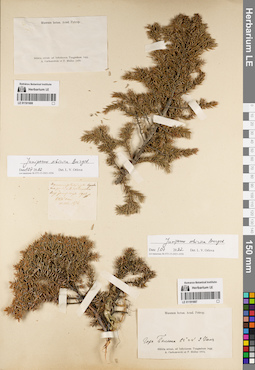
LE 01191687
Juniperus sibirica Burgsd. det. Orlova, Larisa Vladimirovna at 01.07.2022
Collectors: Czekanowski, Alexander Piotr; Müller (Mueller), Ferdinand Ferdinandovich Collection date: 02.06.1873. Administrative regions: RU - Irkutskaya Oblast' - Katangskiy Rayon. Place of collection: р. Нижняя Тунгуска, г. Талюна.Groups of specimens: Образцы сектора Сибири и Дальнего Востока России; Соглашение Минобрнауки №075-15-2021-1056; Museum botan. Acad. Petrop.Original label text:Museum botan. Acad. Petrop. Гора Талюна 62°44' 2 Июня. Siberia orient. ad Inferiorem Tunguskam legg. A. Czekanowski et F. Müller 1873
Landscape in location of collection: склон горыCoordinates (geographic position): 62° 43′ 59.99″ N, 108° 0′ 0″ E ±200000 mRecord creation: 2022-07-01, Larisa Orlova, PhotoScan D2. Part 1.Citation: Specimen LE 01191687 // Virtual herbarium of Komarov Botanical Institute RAS — http://re.herbariumle.ru/01191687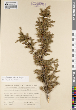
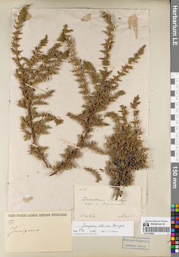
LE 01191686
Juniperus sibirica Burgsd. det. Orlova, Larisa Vladimirovna at 01.07.2022
Additional identifications: Juniperus communis L. det. Katenin, Adrian Evgenevich at 27.01.1956; Juniperus sibirica Burgsd. det. Busch Collectors: Katenin, Adrian Evgenevich Collection date: 25.08.1955. Administrative regions: RU - Yamalo-Nenetskiy Avtonomnyy Okrug - Nadymskiy Rayon. Place of collection: среднее течение р. Ныда выше пос. Хусь-Яга, левый берег, пойменное лиственнично-еловое редколесье на песке.Groups of specimens: Образцы сектора Сибири и Дальнего Востока России; Соглашение Минобрнауки №075-15-2021-1056Original label text:Ботанический институт им. В.Л. Комарова АН СССР. Instituti Botanici nomine V.L. Komarovii Academiae Sc. URSS. Juniperus [communis L. - crossed out] sibirica. Полуостров М. Ямал (Обско-Тазовский) ср. течение р. Ныды выше пос. Хусь-Яга. левый берег. В пойменном лиственнично-еловом редколесье на песке. 1955 25/VIII. собр. Катенин. 1956 27/I. Опр. Катенин
Landscape in location of collection: берег рекиHabitat / plant community in location of collecting: пойменное лиственнично-еловое редколесьеSubstrate in collecting location: песокCoordinates (geographic position): 66° 31′ 26.88″ N, 73° 31′ 20.65″ E ±10000 mRecord creation: 2022-07-01, Larisa Orlova, PhotoScan D2. Part 1.Citation: Specimen LE 01191686 // Virtual herbarium of Komarov Botanical Institute RAS — http://re.herbariumle.ru/01191686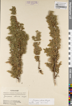
LE 01191685
Juniperus sibirica Burgsd. det. Orlova, Larisa Vladimirovna at 01.07.2022
Additional identifications: Juniperus sibirica Burgsd. det. Krasnoborov, Ivan Moiseevich at 1961 Collectors: Krasnoborov, Ivan Moiseevich Collection date: 10.08.1961. Administrative regions: RU - Krasnoyarskiy Kray - Sayanskiy Rayon. Place of collection: хр. Идарское Белогорье, кедрово-берёзовое редколесье у границы леса.Groups of specimens: Образцы сектора Сибири и Дальнего Востока России; Соглашение Минобрнауки №075-15-2021-1056; Гербарий Сибирского отделения Академии наук СССРOriginal label text:Гербарий Сибирского отделения Академии наук СССР. Juniperus sibirica Burgsd. Красноярский край. Ирбейский район. Идарское белогорье. Кедрово-берёзовое редколесье у границы леса. 10-VIII-1961г. И. Красноборов
Landscape in location of collection: склон горного хребтаHabitat / plant community in location of collecting: кедрово-берёзовое редколесье у границы лесаCoordinates (geographic position): 54° 46′ 19.92″ N, 95° 37′ 5.16″ E ±40000 mRecord creation: 2022-07-01, Larisa Orlova, PhotoScan D2. Part 1.Citation: Specimen LE 01191685 // Virtual herbarium of Komarov Botanical Institute RAS — http://re.herbariumle.ru/01191685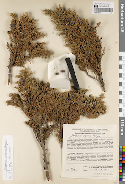
LE 01191684
Juniperus sibirica Burgsd. det. Orlova, Larisa Vladimirovna at 01.07.2022
Additional identifications: Juniperus sibirica Burgsd. det. Fedorov, Alexander Alexandrovich, Fedorov, Andrey Aleksandrovich at 1949 Collectors: Fedorov, Alexander Alexandrovich; Fedorov, Andrey Aleksandrovich; Nikitin, A.A.; Krasilnikov, Pavel Konstantinovich Collection date: 05.09.1949. Administrative regions: RU - Krasnoyarskiy Kray - Sayanskiy Rayon. Place of collection: долина р. Тукши, таежный пояс, каменники.Expedition: Центрально-Саянская экспедиция 1949 (1949)Groups of specimens: Образцы сектора Сибири и Дальнего Востока России; Соглашение Минобрнауки №075-15-2021-1056Original label text:Гербарий Ботанического института Академии наук СССР. Центрально-Саянская экспедиция 1949. Juniperus sibirica Burgsd. Долина реки Тукши. Таежный пояс. Каменники. Собр.: Ал.А. Федоров, Ан.А. Федоров, А.А. Никитин, П.К. Красильников. 1949 5 IX. Опред.: А. и А. Ф[едоровы]
Landscape in location of collection: каменникиHabitat / plant community in location of collecting: таежный поясCoordinates (geographic position): 54° 38′ 12.9″ N, 95° 43′ 12.27″ E ±10000 mRecord creation: 2022-07-01, Larisa Orlova, PhotoScan D2. Part 1.Citation: Specimen LE 01191684 // Virtual herbarium of Komarov Botanical Institute RAS — http://re.herbariumle.ru/01191684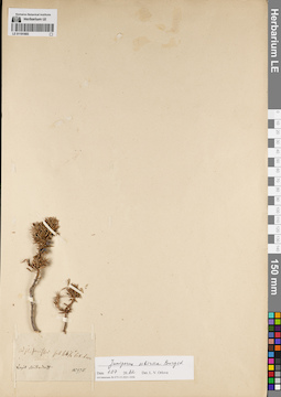
LE 01191683
Groups of specimens: Образцы сектора Сибири и Дальнего Востока России; Соглашение Минобрнауки №075-15-2021-1056Record creation: 2022-07-01, Larisa Orlova, PhotoScan D2. Part 1.Citation: Specimen LE 01191683 // Virtual herbarium of Komarov Botanical Institute RAS — http://re.herbariumle.ru/01191683
LE 01191682
Juniperus sibirica Burgsd. det. Orlova, Larisa Vladimirovna at 01.07.2022
Additional identifications: Juniperus sp. det. Noryin Collectors: Yuriev, A. Collection date: 04.06.1910. Administrative regions: RU - Irkutskaya Oblast' - Bratskiy Rayon. Place of collection: окрестности пос. Кежемский.Groups of specimens: Образцы сектора Сибири и Дальнего Востока России; Соглашение Минобрнауки №075-15-2021-1056Original label text:N 77. Енисейская г. и уезд. окр. с. Кежемского. 1910.4.VI. А. Юрьев.
Coordinates (geographic position): 56° 33′ 12.59″ N, 102° 26′ 48.56″ E ±10000 mRecord creation: 2022-07-01, Larisa Orlova, PhotoScan D2. Part 1.Citation: Specimen LE 01191682 // Virtual herbarium of Komarov Botanical Institute RAS — http://re.herbariumle.ru/01191682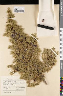
LE 01191681
Juniperus sibirica Burgsd. det. Mironenko, O. at 1966
Collectors: Mironenko, O. Collection date: 23.08.1966. Administrative regions: RU - Krasnoyarskiy Kray - Evenkiyskiy District. Place of collection: берег р. Вилюй возле пос. Эконда.Groups of specimens: Образцы сектора Сибири и Дальнего Востока России; Соглашение Минобрнауки №075-15-2021-1056Original label text:Гербарий Ботанического института Академии наук СССР. Juniperus sibirica. Красноярский кр. Берег р. Вилюя возле ф. Эконда. 1966-23/VIII. Собр. О. Мироненко
Landscape in location of collection: берег рекиCoordinates (geographic position): 65° 45′ 19.14″ N, 105° 20′ 35.24″ E ±2000 mRecord creation: 2022-07-01, Larisa Orlova, PhotoScan D2. Part 1.Citation: Specimen LE 01191681 // Virtual herbarium of Komarov Botanical Institute RAS — http://re.herbariumle.ru/01191681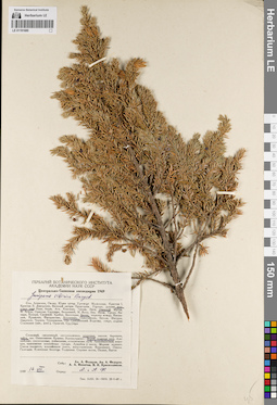
LE 01191680
Juniperus sibirica Burgsd. det. Fedorov, Alexander Alexandrovich, Fedorov, Andrey Aleksandrovich at 1949
Collectors: Fedorov, Alexander Alexandrovich; Fedorov, Andrey Aleksandrovich; Nikitin, A.A.; Krasilnikov, Pavel Konstantinovich Collection date: 16.08.1949. Administrative regions: RU - Irkutskaya Oblast' - Nizhneudinskiy Rayon. Place of collection: верховье р. Озерная, белки Агульские, кедровая тайга, верхняя граница леса.Expedition: Центрально-Саянская экспедиция 1949 (1949)Groups of specimens: Образцы сектора Сибири и Дальнего Востока России; Соглашение Минобрнауки №075-15-2021-1056Original label text:Гербарий Ботанического института Академии наук СССР. Центрально-Саянская экспедиция 1949. Juniperus sibirica Burgsd. Верховье реки Озерной. Белки Агульские. Кедровая тайга. Верхн. граница леса. Собр.: Ал.А. Федоров, Ан.А. Федоров, В.А. Никитин, П.К. Красильников. 1949 16 VIIi. Опред.: А. и А. Ф[едоровы]
Landscape in location of collection: склон белкаHabitat / plant community in location of collecting: кедровая тайгаCoordinates (geographic position): 54° 15′ 48.05″ N, 95° 49′ 18.35″ E ±10000 mRecord creation: 2022-07-01, Larisa Orlova, PhotoScan D2. Part 1.Citation: Specimen LE 01191680 // Virtual herbarium of Komarov Botanical Institute RAS — http://re.herbariumle.ru/01191680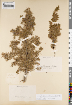
LE 01191679
Juniperus niemannii E.L. Wolf det. Orlova, Larisa Vladimirovna at 30.06.2022
Collectors: Czekanowski, Alexander Piotr; Müller (Mueller), Ferdinand Ferdinandovich Collection date: 31.05.1873. Administrative regions: RU - Irkutskaya Oblast' - Katangskiy Rayon. Place of collection: р. Нижняя Тунгуска, с. Непа.Groups of specimens: Образцы сектора Сибири и Дальнего Востока России; Соглашение Минобрнауки №075-15-2021-1056; Museum botan. Acad. Petrop.Original label text:[1]С. Непа. 31 Мая 1873 [2] Museum botan. Acad. Petrop. Устье р. Ильгишной. 23 Июня. Siberia orient. ad Inferiorem Tunguskam legg. A. Czekanowski et F. Muller 1873
Coordinates (geographic position): 59° 14′ 34.85″ N, 108° 13′ 53.74″ E ±1000 mRecord creation: 2022-07-01, Larisa Orlova, PhotoScan D2. Part 1.. Processing status: sample requires separationCitation: Specimen LE 01191679 // Virtual herbarium of Komarov Botanical Institute RAS — http://re.herbariumle.ru/01191679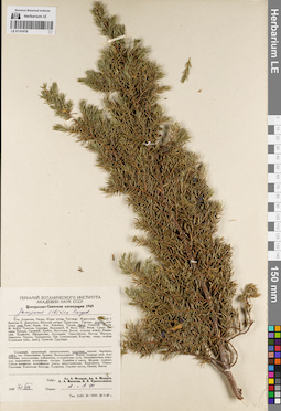
LE 01191678
Juniperus sibirica Burgsd. det. Fedorov, Alexander Alexandrovich, Fedorov, Andrey Aleksandrovich at 1949
Collectors: Fedorov, Alexander Alexandrovich; Fedorov, Andrey Aleksandrovich; Nikitin, A.A.; Krasilnikov, Pavel Konstantinovich Collection date: 31.07.1949. Administrative regions: RU - Krasnoyarskiy Kray - Sayanskiy Rayon. Place of collection: долина р. Янга, кедровая тайга.Expedition: Центрально-Саянская экспедиция 1949 (1949)Groups of specimens: Образцы сектора Сибири и Дальнего Востока России; Соглашение Минобрнауки №075-15-2021-1056Original label text:Гербарий Ботанического института Академии наук СССР. Центрально-Саянская экспедиция 1949. Juniperus sibirica Burgsd. Долина реки Янги. Кедровая тайга. Собр.: Ал.А. Федоров, Ан.А. Федоров, В.А. Никитин, П.К. Красильников. 1949 31 VII. Опред.: А. и А. Ф[едоровы]
Landscape in location of collection: долина рекиHabitat / plant community in location of collecting: кедровая тайгаCoordinates (geographic position): 54° 27′ 7.95″ N, 95° 39′ 31.26″ E ±10000 mRecord creation: 2022-07-01, Larisa Orlova, PhotoScan D2. Part 1.Citation: Specimen LE 01191678 // Virtual herbarium of Komarov Botanical Institute RAS — http://re.herbariumle.ru/01191678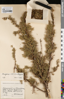
LE 01191677
Juniperus sibirica Burgsd. det. Vassiljev, Viktor Nikolayevich at 1949
Collectors: Sokolov, Ph.V. Collection date: 09.1947. Administrative regions: RU - Krasnoyarskiy Kray - Turukhanskiy Rayon. Place of collection: возле дер. Старотуруханск, возле разреза NN. 10, 12 и 13., в лесу.Groups of specimens: Образцы сектора Сибири и Дальнего Востока России; Соглашение Минобрнауки №075-15-2021-1056Original label text:Herbarium Instituti Botanici Academiae Sc. URSS. Туруханский р-н. Красноярского края. Возле Старо-Туруханска. Возле разреза NN. - 10, 12 и 13. в лесу. 1947 IX. Собр. Ф.В. Соколов
Habitat / plant community in location of collecting: лесCoordinates (geographic position): 65° 54′ 53.29″ N, 87° 34′ 32.67″ E ±5000 mRecord creation: 2022-07-01, Larisa Orlova, PhotoScan D2. Part 1.Citation: Specimen LE 01191677 // Virtual herbarium of Komarov Botanical Institute RAS — http://re.herbariumle.ru/01191677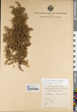
LE 01191676
Juniperus sibirica Burgsd. det. Orlova, Larisa Vladimirovna at 30.06.2022
Additional identifications: Juniperus nana Willd. det. Borovikov, Georgy Andrejevich at 1910 Collectors: Borovikov, Georgy Andrejevich Collection date: 26.07.1910. Administrative regions: RU - Krasnoyarskiy Kray. Place of collection: р. Засеря, бор.Expedition: Западное Заангарье Енисейской губернии. Г. А. Боровиков (1909 -1910)Groups of specimens: Образцы сектора Сибири и Дальнего Востока России; Соглашение Минобрнауки №075-15-2021-1056; Гербарий Переселенческого УправленияOriginal label text:Гербарий Переселенческого Управления. Западное Заангарье Енисейской губернии. Г.А. Боровиков. Juniperus nana Wild. р. Засеря бор 26/VII. 1910 г.
Landscape in location of collection: берег рекиHabitat / plant community in location of collecting: борCoordinates (geographic position): 58° 53′ 51.54″ N, 93° 12′ 40.53″ E ±200000 mRecord creation: 2022-07-01, Larisa Orlova, PhotoScan D2. Part 1.Citation: Specimen LE 01191676 // Virtual herbarium of Komarov Botanical Institute RAS — http://re.herbariumle.ru/01191676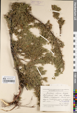
LE 01191675
Juniperus sibirica Burgsd. det. Lovelius, Olga L. at 1967
Collectors: Lovelius, Nikolai Vladimirovich Collection date: 06.08.1967. Administrative regions: RU - Krasnoyarskiy Kray - Evenkiyskiy District. Place of collection: горы Путорана, верховье р. Амнундакта, высота 850 м над ур.м. (наивысший предел распростр. леса), в 15-17 км. от г. Камень.Groups of specimens: Образцы сектора Сибири и Дальнего Востока России; Соглашение Минобрнауки №075-15-2021-1056Original label text:Гербарий Ботанического института Академии наук СССР. Juniperus sibirica Burgsd. Красноярский край, горы Путорана. Верховье р. Амнундакты. Высота 850 м над ур.м. (наивысший предел распростр. леса). В 15-17 км. от г. Камень. 1967 6.VIII. Собр. Н. Ловелиус. Опр. О. Ловелиус. Herbarium Instituti Botanici Academiae Sc. URSS, Leningrad
Landscape in location of collection: горный склонCoordinates (geographic position): 64° 10′ 44.04″ N, 103° 42′ 33.91″ E ±10000 m, 850 m a.s.l.Record creation: 2022-07-01, Larisa Orlova, PhotoScan D2. Part 1.Citation: Specimen LE 01191675 // Virtual herbarium of Komarov Botanical Institute RAS — http://re.herbariumle.ru/01191675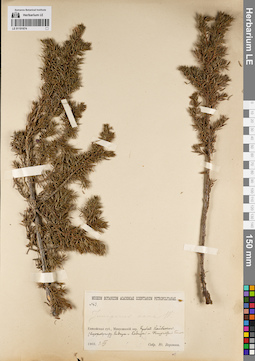
LE 01191674
Juniperus nana Willd. det. Woronov, Jurij (Georg) Nikolaewich at 1903
Collectors: Woronov, Jurij (Georg) Nikolaewich Field collecting number: 43. Collection date: 02.07.1903. Administrative regions: RU - Krasnoyarskiy Kray - Kuraginskiy Rayon. Place of collection: хребет Кайбахчил (водораздел р. Кизыр и р. Казыр), Фигурчатый белок.Groups of specimens: Образцы сектора Сибири и Дальнего Востока России; Соглашение Минобрнауки №075-15-2021-1056Original label text:Museum Botanicum Academiae Scientiarum Petropolitanae. no. 43. Juniperus nana W. Енисейская губ., Минусинский окр. Хребет Кайбахчил. (водораздел рр. Кизыра и Казыра). - Фигурчатый белок. 1903.1.VII Собр. Ю. Воронов
Landscape in location of collection: склон белкаCoordinates (geographic position): 53° 54′ 36.84″ N, 94° 36′ 56.24″ E ±100000 mRecord creation: 2022-07-01, Larisa Orlova, PhotoScan D2. Part 1.Citation: Specimen LE 01191674 // Virtual herbarium of Komarov Botanical Institute RAS — http://re.herbariumle.ru/01191674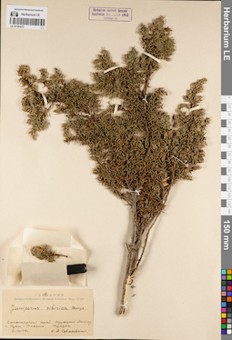
LE 01191673
Juniperus sibirica Burgsd. det. Sobolevskaja, Kira Arkadyevna at 1944
Collectors: Sobolevskaja, Kira Arkadyevna Collection date: 02.08.1944. Administrative regions: RU - Kemerovskaya Oblast'. Place of collection: Кузнецкий Алатау, г. Изык-Таскыл, тундра.Groups of specimens: Образцы сектора Сибири и Дальнего Востока России; Соглашение Минобрнауки №075-15-2021-1056; Гербарий Западно-Сибирского филиала Академии Наук СССРOriginal label text:Гербарий Западно-Сибирского филиала Академии Наук СССР. Juniperus sibirica Burgs. Красноярский край. Кузнецкий Алатау. г. Изык-Таскыл. Тундра. 2-VIII-44. К.А. Соболевская
Landscape in location of collection: склон горыHabitat / plant community in location of collecting: тундраCoordinates (geographic position): 54° 19′ 1.2″ N, 88° 54′ 3.6″ E ±100000 mRecord creation: 2022-07-01, Larisa Orlova, PhotoScan D2. Part 1.Citation: Specimen LE 01191673 // Virtual herbarium of Komarov Botanical Institute RAS — http://re.herbariumle.ru/01191673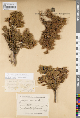
LE 01191672
Juniperus sibirica Burgsd. det. Orlova, Larisa Vladimirovna at 30.06.2022
Additional identifications: Juniperus nana Willd. det. Tugarinov, Arkadiy Yakovlevich at 1912 Collectors: Tugarinov, Arkadiy Yakovlevich Collection date: 30.05.1912. Administrative regions: RU - Krasnoyarskiy Kray - Partizanskiy Rayon. Place of collection: хр. Кутурчинское Белогорье, граница леса.Expedition: А.Я. Тугаринов: Растения Саянских гор (1912)Groups of specimens: Образцы сектора Сибири и Дальнего Востока России; Соглашение Минобрнауки №075-15-2021-1056Original label text:[1]Можжевельник. Н. Хмпетру. граница леса Хребет Кутурчина 30/V 1912 [2] А.Я. Тугаринов: Растения Саянских гор. Juniperus nana Willd. Енисейская губ. Красн. уезд: граница леса, хребет Кутурчина. 1912 30/V. A.I. Tugarinow: Plantae montium Sajanensium
Landscape in location of collection: склон горного хребтаHabitat / plant community in location of collecting: граница лесаCoordinates (geographic position): 54° 58′ 25.32″ N, 94° 3′ 58.3″ E ±10000 mRecord creation: 2022-07-01, Larisa Orlova, PhotoScan D2. Part 1.Citation: Specimen LE 01191672 // Virtual herbarium of Komarov Botanical Institute RAS — http://re.herbariumle.ru/01191672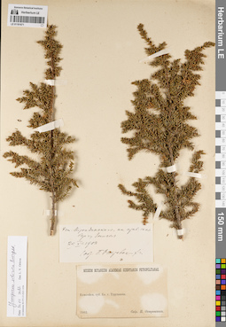
LE 01191671
Juniperus sibirica Burgsd. det. Orlova, Larisa Vladimirovna at 30.06.2022
Collectors: Ostrovskikh, Pyotr Yevgenievich Collection date: 29.06.1902. Administrative regions: RU - Krasnoyarskiy Kray - Turukhanskiy Rayon. Place of collection: близ с. Туруханск, ст. Мирондинский, правый скалистый берег р. Енисей.Groups of specimens: Образцы сектора Сибири и Дальнего Востока России; Соглашение Минобрнауки №075-15-2021-1056Original label text:[1]У ст. Мирондинского, на прав. скал. берегу Енисея. 29.VI.1902. Собр. П. Островских [2] Museum Botanicum Academiae Scientiarum Petropolitanae. Енисейск. губ. Бл. г. Туруханска. 1902. Собр. П. Островских
Landscape in location of collection: правый скалистый берег крупной рекиCoordinates (geographic position): 65° 50′ 30.49″ N, 87° 50′ 55.27″ E ±10000 mRecord creation: 2022-07-01, Larisa Orlova, PhotoScan D2. Part 1.Citation: Specimen LE 01191671 // Virtual herbarium of Komarov Botanical Institute RAS — http://re.herbariumle.ru/01191671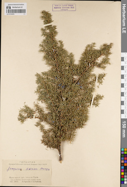
LE 01191670
Juniperus sibirica Burgsd. det. Koroleva, Anna Sergeyevna, Minaeva, V.G. at 1946
Collectors: Koroleva, Anna Sergeyevna; Minaeva, V.G. Collection date: 08.1946. Administrative regions: RU - Krasnoyarskiy Kray - Yermakovskiy Rayon. Place of collection: Западные Саяны, окрестности ст. Буйба, скалистый лесной склон.Groups of specimens: Образцы сектора Сибири и Дальнего Востока России; Соглашение Минобрнауки №075-15-2021-1056; Гербарий Западно-Сибирского филиала Академии Наук СССРOriginal label text:Гербарий Западно-Сибирского филиала Академии Наук СССР. Juniperus sibirica Burgs. Красноярский край. Западные Саяны. Окр. ст. Буйба. Скалистый лесной склон. VIII-1946г. А. Королева и В. Минаева
Landscape in location of collection: скалистый лесной склонHabitat / plant community in location of collecting: лесCoordinates (geographic position): 52° 50′ 4.26″ N, 93° 20′ 19.39″ E ±2000 mRecord creation: 2022-07-01, Larisa Orlova, PhotoScan D2. Part 1.Citation: Specimen LE 01191670 // Virtual herbarium of Komarov Botanical Institute RAS — http://re.herbariumle.ru/01191670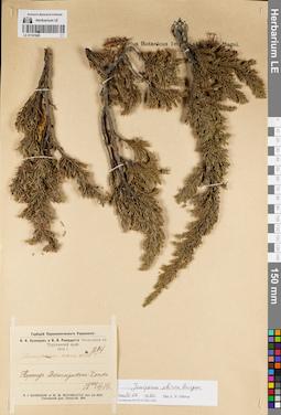
LE 01191669
Juniperus sibirica Burgsd. det. Orlova, Larisa Vladimirovna at 30.06.2022
Additional identifications: Juniperus nana Willd. det. Kusnezow, Nicolai Ivanovitch, Reverdatto, Viktor Vladimirovich at 1914 Collectors: Kusnezow, Nicolai Ivanovitch; Reverdatto, Viktor Vladimirovich Field collecting number: 1294. Collection date: 22.07.1914. Administrative regions: RU - Krasnoyarskiy Kray - Evenkiyskiy District. Place of collection: переход р. Дагыльдыкан - р. Чопко.Expedition: Н.И. Кузнецов и В.В. Ревердатто. Экспедиция в Туруханский край. 1914 г. (1914)Groups of specimens: Образцы сектора Сибири и Дальнего Востока России; Соглашение Минобрнауки №075-15-2021-1056; Гербарий Переселенческого УправленияOriginal label text:Гербарий Переселенческого Управления. Н.И. Кузнецов и В.В. Ревердатто Экспедиция в Туруханский край. 1914 г. № 1294. Juniperus nana Willd. Переход Дагыльдыкан-Чопко. 22/VII 1914. N.I. Kuznezow et W.W. Reverdatto. Iter ad distr. Turuchank gub. Enisseisk. 1914
Coordinates (geographic position): 61° 59′ 21.74″ N, 104° 41′ 15.43″ E ±40000 mRecord creation: 2022-07-01, Larisa Orlova, PhotoScan D2. Part 1.Citation: Specimen LE 01191669 // Virtual herbarium of Komarov Botanical Institute RAS — http://re.herbariumle.ru/01191669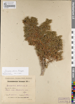
LE 01191668
Juniperus sibirica Burgsd. det. Orlova, Larisa Vladimirovna at 30.06.2022
Additional identifications: Juniperus communis L. det. Avrorin, Nikolay Alexandrovich at 1929 Collectors: Leptan, A. Collection date: 14.07.1929. Administrative regions: RU - Respublika Altay - Ulaganskiy Rayon. Place of collection: берег оз. Балыкту-кёль.Expedition: Лесоэкономическая Экспедиция 1929 г. (1929)Groups of specimens: Образцы сектора Сибири и Дальнего Востока России; Соглашение Минобрнауки №075-15-2021-1056Original label text:Управление Лесами НКЗ. РСФСР. Лесоэкономическая Экспедиция 1929 г. Juniperus communis L. Ойротская Авт. Область. Берега озера Балыкты-коль. 14 VII 1929 г. Собрал А. Лептан. Определил Н. Аврорин
Landscape in location of collection: берег озераCoordinates (geographic position): 50° 32′ 5.72″ N, 87° 41′ 54.23″ E ±5000 mRecord creation: 2022-07-01, Larisa Orlova, PhotoScan D2. Part 1.Citation: Specimen LE 01191668 // Virtual herbarium of Komarov Botanical Institute RAS — http://re.herbariumle.ru/01191668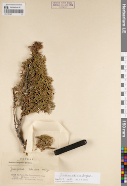
LE 01191667
Juniperus sibirica Burgsd. det. Orlova, Larisa Vladimirovna at 30.06.2022
Additional identifications: Juniperus sibirica Burgsd. det. Kuminova, Alexandra Vladimirovna, Pavlova, G. at 1947 Collectors: Kuminova, Alexandra Vladimirovna; Pavlova, G. Collection date: 18.07.1947. Administrative regions: RU - Respublika Altay - Chemal'skiy Rayon. Place of collection: Алтай, хр. Иолго, окрестности Каракольского озера, скалы.Groups of specimens: Образцы сектора Сибири и Дальнего Востока России; Соглашение Минобрнауки №075-15-2021-1056; Гербарий Западно-Сибирского филиала Академии Наук СССРOriginal label text:Гербарий Западно-Сибирского филиала Академии Наук СССР. Juniperus sibirica Burgs. Алтай. Хр. Иолго. Окр. Каракольского озера. Скалы. Высота 2000 м. 18-29-VII-1947г. А.В. Куминова. Г. Павлова
Landscape in location of collection: скалы на берегу озераCoordinates (geographic position): 51° 29′ 32.13″ N, 86° 22′ 26.81″ E ±2000 m, 2000 m a.s.l.Record creation: 2022-07-01, Larisa Orlova, PhotoScan D2. Part 1.Citation: Specimen LE 01191667 // Virtual herbarium of Komarov Botanical Institute RAS — http://re.herbariumle.ru/01191667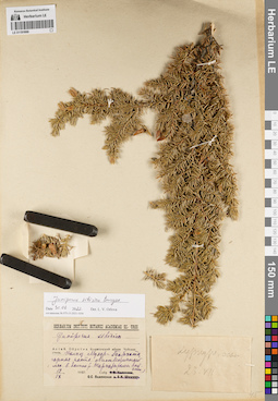
LE 01191666
Juniperus sibirica Burgsd. det. Orlova, Larisa Vladimirovna at 30.06.2022
Additional identifications: Juniperus sibirica Burgsd. det. Polyanskaya, O. S. at 1937 Collectors: Polyanskaya, O. S. Collection date: 19.09.1937. Administrative regions: RU - Respublika Altay - Kosh-Agachskiy Rayon. Place of collection: с. Мухор-Тархата, колхоз Мухор-Тархата, горная часть, лиственничный лес в долине р. Тархата, склон восточной экспозиции.Groups of specimens: Образцы сектора Сибири и Дальнего Востока России; Соглашение Минобрнауки №075-15-2021-1056Original label text:[1]Куркуре, осып. 23.VII [2]Herbarium Instituti Botanici Academiae Sc. URSS. Juniperus sibirica. Алтай. Ойротия. Кошагачский аймак. Чуйская степь. Колхоз Мухар-Тархата, горная часть. Лиственичный лес в долине р. Тархаты (склон вост. эксп.). 19 IX 1937. Собр. О.С. Полянская
Landscape in location of collection: склон восточной экспозиции в долине рекиHabitat / plant community in location of collecting: лиственничный лесCoordinates (geographic position): 49° 54′ 34.02″ N, 88° 38′ 19.54″ E ±10000 mRecord creation: 2022-07-01, Larisa Orlova, PhotoScan D2. Part 1.Citation: Specimen LE 01191666 // Virtual herbarium of Komarov Botanical Institute RAS — http://re.herbariumle.ru/01191666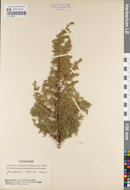
LE 01191665
Juniperus sibirica Burgsd. det. Krasnoborov, Ivan Moiseevich at 1961
Collectors: Krasnoborov, Ivan Moiseevich Collection date: 13.08.1961. Administrative regions: RU - Krasnoyarskiy Kray - Irbeyskiy Rayon. Place of collection: хр. Идарское Белогорье, окрестности оз. Кускунак, тундра.Groups of specimens: Образцы сектора Сибири и Дальнего Востока России; Соглашение Минобрнауки №075-15-2021-1056; Гербарий Сибирского отделения Академии наук СССРOriginal label text:Гербарий Сибирского отделения Академии наук СССР. Juniperus sibirica Burgsd. Красноярский край. Ирбейский район. Идарское белогорье. Окр. оз. Кускунак. Тундра. 13-VIII-1961г. И. Красноборов
Habitat / plant community in location of collecting: тундраCoordinates (geographic position): 54° 49′ 29.69″ N, 95° 34′ 42.87″ E ±1000 mRecord creation: 2022-07-01, Larisa Orlova, PhotoScan D2. Part 1.Citation: Specimen LE 01191665 // Virtual herbarium of Komarov Botanical Institute RAS — http://re.herbariumle.ru/01191665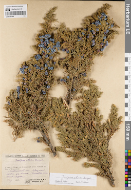
LE 01191664
Juniperus sibirica Burgsd. det. Knorring, I. G., Schtakelberg, B.A. at 1937
Additional identifications: Juniperus sibirica Burgsd. det. Orlova, Larisa Vladimirovna at 30.06.2022 Collectors: Knorring, I. G.; Schtakelberg, B.A. Collection date: 15.08.1937. Administrative regions: RU - Respublika Altay - Kosh-Agachskiy Rayon. Place of collection: Чуйский хр., ущелье р. Чаганузун, северный склон ущелья Джело, верховья р. Чаганузун, лиственничный лес.Groups of specimens: Образцы сектора Сибири и Дальнего Востока России; Соглашение Минобрнауки №075-15-2021-1056Original label text:Herbarium Instituti Botanici Academiae Sc. URSS. Juniperus sibirica Burgsd. Алтай. Ойротия, Кошагачский аймак. Чуйский хр. Ущ. р. Чеган-узуна. Лиственичный лес. Северный склон ущ. Джело /верховья реки Чеган-Узуна/. 15/VIII 1937. собр. Опр. Штакельберг Б.А. и Кнорринг И.Г.
Landscape in location of collection: северный склон ущельяHabitat / plant community in location of collecting: лиственничный лесCoordinates (geographic position): 49° 58′ 57.53″ N, 88° 10′ 14.37″ E ±50000 mRecord creation: 2022-07-01, Larisa Orlova, PhotoScan D2. Part 1.Citation: Specimen LE 01191664 // Virtual herbarium of Komarov Botanical Institute RAS — http://re.herbariumle.ru/01191664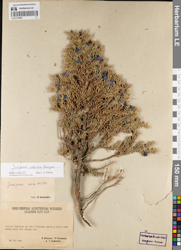
LE 01191663
Juniperus sibirica Burgsd. det. Orlova, Larisa Vladimirovna at 30.06.2022
Additional identifications: Juniperus nana Willd. det. Schischkin, Boris Konstantinovich Collectors: Chilikina, L. N.; Sumnevich, Georgy Prokopyevich; Schischkin, Boris Konstantinovich Collection date: 23.07.1931. Administrative regions: RU - Respublika Altay - Kosh-Agachskiy Rayon. Place of collection: Алтай, р. Куркуре (приток р. Аргут), каменистая осыпь близ границы леса.Expedition: Южно-Сибирская флористическая экспедиция Академии Наук СССР (1931)Groups of specimens: Образцы сектора Сибири и Дальнего Востока России; Соглашение Минобрнауки №075-15-2021-1056Original label text:Южно-Сибирская флористическая экспедиция Академии Наук СССР. Алтай. Ойротская авт. обл. Р. Куркуре, приток р. Аргута, каменистая осыпь близ границы леса. 23.VII.1931. Б. Шишкин, Л. Чиликина и Г. Сумневич
Landscape in location of collection: каменистая осыпь близ границы лесаHabitat / plant community in location of collecting: граница лесаCoordinates (geographic position): 49° 50′ 55.67″ N, 87° 1′ 5.3″ E ±10000 mRecord creation: 2022-07-01, Larisa Orlova, PhotoScan D2. Part 1.Citation: Specimen LE 01191663 // Virtual herbarium of Komarov Botanical Institute RAS — http://re.herbariumle.ru/01191663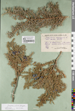
LE 01191662
Juniperus sibirica Burgsd. det. Orlova, Larisa Vladimirovna at 30.06.2022
Additional identifications: Juniperus communis var. nana Willd. det. Kalinina, A.V., Sokolova, Lidiya Alexeevna, Schischkin, Boris Konstantinovich at 1936 Collectors: Kalinina, A.V.; Sokolova, Lidiya Alexeevna; Schischkin, Boris Konstantinovich Collection date: 19.09.1936. Administrative regions: RU - Respublika Altay - Kosh-Agachskiy Rayon. Place of collection: долина р. Карагем, левый коренной берег р. Карагем, елово-лиственничный лес.Groups of specimens: Образцы сектора Сибири и Дальнего Востока России; Соглашение Минобрнауки №075-15-2021-1056Original label text:Herbarium Instituti Botanici Academiae Sc. URSS. Juniperus communis L. var. nana Willd. Алтай, Ойротия, Кошагачский аймак. Дол. р. Карагема. Лев. корен. берег. Елово-лиственничный лес. 19/IX 1936. Собр. А.В. Калинина, Л.А. Соколова и Б.К. Шишкин
Landscape in location of collection: левый коренной берег рекиHabitat / plant community in location of collecting: елово-лиственничный лесCoordinates (geographic position): 49° 54′ 52.6″ N, 87° 23′ 19.98″ E ±20000 mRecord creation: 2022-07-01, Larisa Orlova, PhotoScan D2. Part 1.Citation: Specimen LE 01191662 // Virtual herbarium of Komarov Botanical Institute RAS — http://re.herbariumle.ru/01191662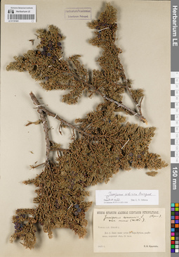
LE 01191661
Juniperus sibirica Burgsd. det. Orlova, Larisa Vladimirovna at 30.06.2022
Additional identifications: Juniperus communis var. nana Willd. det. Krylov, Porphyriy Nikitich at 1915 Collectors: Krylov, Porphyriy Nikitich Collection date: 24.07.1915. Administrative regions: RU - Altayskiy Kray. Place of collection: долина р. Лажа выше устья р. Кара-Ирбак, разреженный кедровый лес.Groups of specimens: Образцы сектора Сибири и Дальнего Востока России; Соглашение Минобрнауки №075-15-2021-1056Original label text:Museum Botanicum Academiae Scientiarum Petropolitanae. Juniperus communis L. var. nana (Willd.) (Крыл.) Томск. губ. Бийский у. Дол. р. Лажи выше устья р. Кара-Ирбака, разреженн. кедровый лес. 24 июля. 1915 г. П.Н. Крылов
Landscape in location of collection: берег рекиHabitat / plant community in location of collecting: разреженный кедровый лесCoordinates (geographic position): 52° 35′ 46.43″ N, 85° 34′ 53.46″ E ±300000 mRecord creation: 2022-07-01, Larisa Orlova, PhotoScan D2. Part 1.Citation: Specimen LE 01191661 // Virtual herbarium of Komarov Botanical Institute RAS — http://re.herbariumle.ru/01191661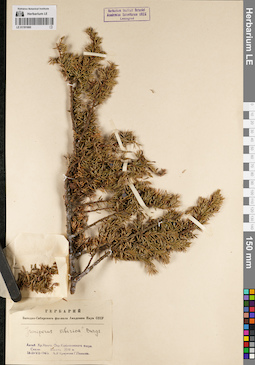
LE 01191660
Juniperus sibirica Burgsd. det. Kuminova, Alexandra Vladimirovna, Pavlova, G. at 1947
Collectors: Kuminova, Alexandra Vladimirovna; Pavlova, G. Collection date: 18.07.1947. Administrative regions: RU - Respublika Altay - Chemal'skiy Rayon. Place of collection: Алтай, хр. Иолго, окрестности оз. Каракольское, скалы.Groups of specimens: Образцы сектора Сибири и Дальнего Востока России; Соглашение Минобрнауки №075-15-2021-1056; Гербарий Западно-Сибирского филиала Академии Наук СССРOriginal label text:Гербарий Западно-Сибирского филиала Академии Наук СССР. Juniperus sibirica Burgs. Алтай. Хр. Иолго. Окр. Каракольского озера. Скалы. Высота 2000 м. 18-29-VII-1947г. А.В. Куминова Г.Павлова
Landscape in location of collection: скалы на склоне горного хребтаCoordinates (geographic position): 51° 29′ 39.17″ N, 86° 22′ 48.11″ E ±2000 m, 2000 m a.s.l.Record creation: 2022-07-01, Larisa Orlova, PhotoScan D2. Part 1.Citation: Specimen LE 01191660 // Virtual herbarium of Komarov Botanical Institute RAS — http://re.herbariumle.ru/01191660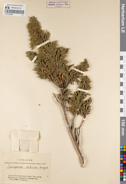
LE 01191659
Juniperus sibirica Burgsd. det. Listova, N. at 1953
Collectors: Listova, N. Collection date: 06.07.1953. Administrative regions: RU - Respublika Altay - Ust'-Koksinskiy Rayon. Place of collection: окрестности с. Абай, верховья кл. Таралонкин (Тарланова), кедровый лес.Groups of specimens: Образцы сектора Сибири и Дальнего Востока России; Соглашение Минобрнауки №075-15-2021-1056; Гербарий Западно-Сибирского филиала Академии Наук СССРOriginal label text:Гербарий Западно-Сибирского филиала Академии Наук СССР. Juniperus sibirica Burgsd. Алтай. Усть-Коксинский аймак. Окр. с. Абай. Верховья кл. Тарланова. Кедровый лес. 6-VII-1953г. Н. Листова
Landscape in location of collection: берег рекиHabitat / plant community in location of collecting: кедровый лесCoordinates (geographic position): 50° 29′ 31.03″ N, 85° 11′ 36.29″ E ±10000 mRecord creation: 2022-07-01, Larisa Orlova, PhotoScan D2. Part 1.Citation: Specimen LE 01191659 // Virtual herbarium of Komarov Botanical Institute RAS — http://re.herbariumle.ru/01191659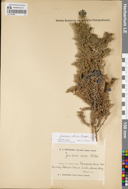
LE 01191658
Juniperus sibirica Burgsd. det. Orlova, Larisa Vladimirovna at 30.06.2022
Additional identifications: Juniperus nana Willd. det. Nekrasova, Vera Leontievna at 1911 Collectors: Nekrasova, Vera Leontievna Collection date: 22.07.1911. Administrative regions: RU - Respublika Altay - Kosh-Agachskiy Rayon. Place of collection: Катунские белки, верхняя долина р. Иедыгем, скалы близ ледника Менсу.Expedition: В.Л. Некрасова: Растения Горного Алтая (1911)Groups of specimens: Образцы сектора Сибири и Дальнего Востока России; Соглашение Минобрнауки №075-15-2021-1056Original label text:В.Л. Некрасова: Растения Горного Алтая. Juniperus nana Willd. Томская губ. Бийский уезд: Катунские белки. Верхн. долина р. Иедыгема. Скалы близ ледника Мёнсу. 22 июля 1911. W.L. Nekrassowa: Plantae Altaicae montanae
Landscape in location of collection: скалы в долине реки близ ледникаCoordinates (geographic position): 49° 51′ 20.2″ N, 86° 40′ 53.1″ E ±5000 mRecord creation: 2022-07-01, Larisa Orlova, PhotoScan D2. Part 1.Citation: Specimen LE 01191658 // Virtual herbarium of Komarov Botanical Institute RAS — http://re.herbariumle.ru/01191658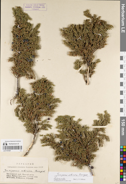
LE 01191657
Juniperus sibirica Burgsd. det. Ershova, E., Vassiljev, Yu. at 1962
Additional identifications: Juniperus sibirica Burgsd. det. Orlova, Larisa Vladimirovna at 30.06.2022 Collectors: Ershova, E.; Vassiljev, Yu. Collection date: 22.06.1962. Administrative regions: RU - Krasnoyarskiy Kray - Manskiy Rayon. Place of collection: окрестности дер. Жайма, г. Арыгджек, граница леса.Groups of specimens: Образцы сектора Сибири и Дальнего Востока России; Соглашение Минобрнауки №075-15-2021-1056; Гербарий Сибирского отделения Академии наук СССРOriginal label text:Гербарий Сибирского отделения Академии наук СССР. Juniperus sibirica Burgsd. Красноярский край. Манский район. Окр. д. Жайма. г. Арыгджек. Граница леса. 22-VI-1962г. Ю. Васильев, Э. Ершова
Landscape in location of collection: склон горыHabitat / plant community in location of collecting: граница лесаCoordinates (geographic position): 54° 53′ 47.37″ N, 93° 40′ 48.4″ E ±2000 mRecord creation: 2022-07-01, Larisa Orlova, PhotoScan D2. Part 1.Citation: Specimen LE 01191657 // Virtual herbarium of Komarov Botanical Institute RAS — http://re.herbariumle.ru/01191657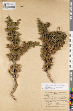
LE 01191656
Juniperus sibirica Burgsd. det. Orlova, Larisa Vladimirovna at 30.06.2022
Additional identifications: Juniperus nana Willd. det. Pobedimova, Evgeniia Georgievna at 1929 Collectors: Pobedimova, Evgeniia Georgievna Field collecting number: 584. Collection date: 06.08.1929. Administrative regions: RU - Respublika Altay - Ust'-Kanskiy Rayon. Place of collection: район с. Черный Ануй, Талицкие белки, близ р. Талицы, кедровый лес на камнях.Expedition: Е.Г. Победимова: Растения Горного Алтая (1928 -1929)Groups of specimens: Образцы сектора Сибири и Дальнего Востока России; Соглашение Минобрнауки №075-15-2021-1056Original label text:Е.Г. Победимова: Растения Горного Алтая. N 584. Juniperus nana Willd. Бийский округ, район Черного Ануя. Талицкие белки. Близ р. Талицы. В кедровом лесу, на камнях. 6 VIII 1929 г. Собр. Опр. Е.Г. Победимова. E. Pobedimova. Plantae Altaicae montanae
Landscape in location of collection: на камняхHabitat / plant community in location of collecting: кедровый лесCoordinates (geographic position): 51° 10′ 29.1″ N, 84° 26′ 39.84″ E ±20000 mRecord creation: 2022-07-01, Larisa Orlova, PhotoScan D2. Part 1.Citation: Specimen LE 01191656 // Virtual herbarium of Komarov Botanical Institute RAS — http://re.herbariumle.ru/01191656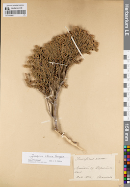
LE 01191655
Juniperus sibirica Burgsd. det. Orlova, Larisa Vladimirovna at 30.06.2022
Additional identifications: Juniperus nana Willd. det. Ignatov, Pavel Grigor'evich at 1901 Collectors: Ignatov, Pavel Grigor'evich Collection date: 12.08.1901. Administrative regions: RU - Respublika Altay - Turochakskiy Rayon. Place of collection: Алтай, оз. Джюйлю-коль.Groups of specimens: Образцы сектора Сибири и Дальнего Востока России; Соглашение Минобрнауки №075-15-2021-1056Original label text:Juniperus nana. Алтай. оз. Джюйлю-коль. 12 авг. 1901 г. Игнатов
Landscape in location of collection: берег озераCoordinates (geographic position): 51° 33′ 31.48″ N, 87° 37′ 36.83″ E ±30000 mRecord creation: 2022-07-01, Larisa Orlova, PhotoScan D2. Part 1.Citation: Specimen LE 01191655 // Virtual herbarium of Komarov Botanical Institute RAS — http://re.herbariumle.ru/01191655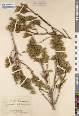
LE 01191654
Juniperus sibirica Burgsd. det. Pestunova, L., Bogushevskaya, N. at 1931
Collectors: Pestunova, L.; Bogushevskaya, N. Collection date: 24.07.1931. Administrative regions: RU - Respublika Altay - Ust'-Koksinskiy Rayon. Place of collection: окрестности с. Сугаш, смешанный лес.Groups of specimens: Образцы сектора Сибири и Дальнего Востока России; Соглашение Минобрнауки №075-15-2021-1056; Гербарий Западно-Сибирского филиала Академии Наук СССРOriginal label text:Гербарий Западно-Сибирского филиала Академии Наук СССР. Juniperus sibirica Burgs. Алтай. Усть-Канский аймак. Окр. с. Су[г]аш. Смешанный лес. 24-VII-19[3]1 г. Л. Пестунова Н. Богушевская
Habitat / plant community in location of collecting: смешанный лесCoordinates (geographic position): 50° 33′ 58.97″ N, 84° 57′ 35.87″ E ±10000 mRecord creation: 2022-07-01, Larisa Orlova, PhotoScan D2. Part 1.Citation: Specimen LE 01191654 // Virtual herbarium of Komarov Botanical Institute RAS — http://re.herbariumle.ru/01191654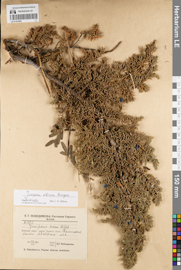
LE 01191653
Juniperus sibirica Burgsd. det. Orlova, Larisa Vladimirovna at 30.06.2022
Additional identifications: Juniperus nana Willd. det. Pobedimova, Evgeniia Georgievna at 1928 Collectors: Pobedimova, Evgeniia Georgievna Field collecting number: 107в. Collection date: 16.07.1928. Administrative regions: RU - Respublika Altay - Ust'-Kanskiy Rayon. Place of collection: район с. Черный Ануй, Талицкие белки, хвойный лес.Expedition: Е.Г. Победимова: Растения Горного Алтая (1928 -1929)Groups of specimens: Образцы сектора Сибири и Дальнего Востока России; Соглашение Минобрнауки №075-15-2021-1056Original label text:Е.Г. Победимова: Растения Горного Алтая. N 107в. Juniperus nana Willd. Бийский округ, район Черного Ануя. Талицкие белки. Хвойный лес. 16 / VII 1928 г. Собр. Опр. Е.Г. Победимова. E. Pobedimova. Plantae Altaicae montanae
Landscape in location of collection: склон белкаHabitat / plant community in location of collecting: хвойный лесCoordinates (geographic position): 51° 21′ 23.89″ N, 84° 43′ 36.31″ E ±50000 mRecord creation: 2022-07-01, Larisa Orlova, PhotoScan D2. Part 1.Citation: Specimen LE 01191653 // Virtual herbarium of Komarov Botanical Institute RAS — http://re.herbariumle.ru/01191653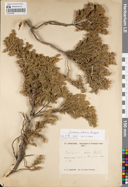
LE 01191652
Juniperus sibirica Burgsd. det. Orlova, Larisa Vladimirovna at 30.06.2022
Additional identifications: Juniperus nana Willd. det. Ignatov, Pavel Grigor'evich at 1901 Collectors: Ignatov, Pavel Grigor'evich Collection date: 12.08.1901. Administrative regions: RU - Respublika Altay - Turochakskiy Rayon. Place of collection: берег оз. Джейлю-Кель.Expedition: П.Г. Игнатов: Экспедиция на Телецкое озеро 1901 г. (1901)Groups of specimens: Образцы сектора Сибири и Дальнего Востока России; Соглашение Минобрнауки №075-15-2021-1056Original label text:П.Г. Игнатов: Экспедиция на Телецкое озеро 1901 г. Juniperus nana Willd. Восточн. Алтай: берега оз. Джейлю-кель. 12.VIII P.G. Ignatow: Iter ad lacum Telezkoje
Landscape in location of collection: берег озераCoordinates (geographic position): 51° 33′ 31.48″ N, 87° 37′ 36.83″ E ±30000 mRecord creation: 2022-07-01, Larisa Orlova, PhotoScan D2. Part 1.Citation: Specimen LE 01191652 // Virtual herbarium of Komarov Botanical Institute RAS — http://re.herbariumle.ru/01191652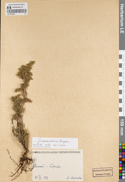
LE 01191651
Juniperus sibirica Burgsd. det. Orlova, Larisa Vladimirovna at 30.06.2022
Collectors: Morozova, M. Collection date: 20.07.1927. Administrative regions: RU - Altayskiy Kray - Soloneshenskiy Rayon. Place of collection: Алтай, г. Каракол.Groups of specimens: Образцы сектора Сибири и Дальнего Востока России; Соглашение Минобрнауки №075-15-2021-1056Original label text:Museum Botanicum Academiae Scientiarum Petropolitanae. Алтай. г. Каракол. 20.VII.1927. М. Морозова
Landscape in location of collection: склон горыCoordinates (geographic position): 51° 23′ 10.32″ N, 84° 39′ 50.15″ E ±2000 mRecord creation: 2022-07-01, Larisa Orlova, PhotoScan D2. Part 1.Citation: Specimen LE 01191651 // Virtual herbarium of Komarov Botanical Institute RAS — http://re.herbariumle.ru/01191651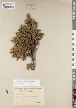
LE 01191650
Juniperus sibirica Burgsd. det. Orlova, Larisa Vladimirovna at 30.06.2022
Additional identifications: Juniperus communis var. nana Willd. det. Krylov, Porphyriy Nikitich Collectors: Krylov, Porphyriy Nikitich Collection date: 21.07.1915. Administrative regions: RU - Respublika Altay - Chemal'skiy Rayon. Place of collection: верховья р. Аккая (Ак-Кая, приток р. Куба), южные скалистые склоны.Groups of specimens: Образцы сектора Сибири и Дальнего Востока России; Соглашение Минобрнауки №075-15-2021-1056Original label text:Museum Botanicum Academiae Scientiarum Petropolitanae. Juniperus communis L. var. nana (Willd.) (Крыл.) Томск. губ. Бийский у. Верховья р. Ак-кая (прит. Кубы), южные скалистые склоны. 21 июля. 1915 г. П.Н. Крылов
Landscape in location of collection: южные скалистые склоныCoordinates (geographic position): 51° 22′ 27.99″ N, 86° 34′ 5.14″ E ±5000 mRecord creation: 2022-07-01, Larisa Orlova, PhotoScan D2. Part 1.Citation: Specimen LE 01191650 // Virtual herbarium of Komarov Botanical Institute RAS — http://re.herbariumle.ru/01191650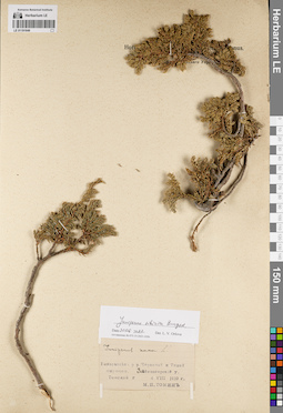
LE 01191649
Juniperus sibirica Burgsd. det. Orlova, Larisa Vladimirovna at 30.06.2022
Additional identifications: Juniperus nana Willd. det. Tomin, Mikhail Petrovich at 1910 Collectors: Tomin, Mikhail Petrovich Collection date: 04.08.1910. Administrative regions: KZ - East Kazakhstan. Subregion: Алтайский район. Place of collection: водораздел р. Черневая и р. Тихая Бирюкса.Groups of specimens: Образцы сектора Сибири и Дальнего Востока России; Соглашение Минобрнауки №075-15-2021-1056Original label text:Juniperus nana L. Водораздел р.р. Черновой и Тихой Бирюксы. Змеиногорский у. Томской г. 4 VIII 1910 г. М.П. Томин
Landscape in location of collection: водораздел двух рекCoordinates (geographic position): 50° 0′ 24.36″ N, 85° 0′ 3.65″ E ±5000 mRecord creation: 2022-07-01, Larisa Orlova, PhotoScan D2. Part 1.Citation: Specimen LE 01191649 // Virtual herbarium of Komarov Botanical Institute RAS — http://re.herbariumle.ru/01191649
LE 01191648
Juniperus sabina L. det. Kolesnikova, N., Danilov, M. at 1981
Collectors: Kolesnikova, N.; Danilov, M. Collection date: 28.07.1981. Administrative regions: RU - Respublika Altay - Ulaganskiy Rayon. Place of collection: южный склон хр. Курайский по правому борту долина р. Мена, выс. 1600м.Groups of specimens: Образцы сектора Сибири и Дальнего Востока России; Соглашение Минобрнауки №075-15-2021-1056; Гербарий Центрального Сибирского ботанического сада СО АН СССРOriginal label text:Гербарий Центрального Сибирского ботанического сада СО АН СССР. Juniperus sabina L. Горно-Алтайская авт.обл., Улаганский р-н, окр. п. Акташ. 50° 10' с.ш. 87° 30' в.д. Южный склон Курайского хребта по правому борту долина р. Мена, выс. 1600м. Галечниковая осыпь террасы. 28.7.1981г. М. Данилов, Н. Колесникова
Landscape in location of collection: галечниковая осыпь террасы горной рекиCoordinates (geographic position): 50° 22′ 10.44″ N, 87° 59′ 57.51″ E ±30000 m, 1600 m a.s.l.Record creation: 2022-07-01, Larisa Orlova, PhotoScan D2. Part 1.Citation: Specimen LE 01191648 // Virtual herbarium of Komarov Botanical Institute RAS — http://re.herbariumle.ru/01191648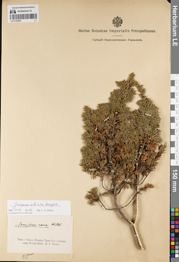
LE 01191647
Juniperus sibirica Burgsd. det. Orlova, Larisa Vladimirovna at 30.06.2022
Additional identifications: Juniperus nana Willd. det. Titov, V. S. at 1910 Collectors: Titov, V. S. Collection date: 24.06.1910. Administrative regions: RU - Kemerovskaya Oblast' - Novokuznetskiy Rayon. Place of collection: истоки р. Средняя Терсь, берег нижнего озера.Groups of specimens: Образцы сектора Сибири и Дальнего Востока России; Соглашение Минобрнауки №075-15-2021-1056Original label text:Juniperus nana Willd. Томск.г. Кузн. у. Истоки р. Терси. Берега нижнего озера. 24 июня 1910 г. В.С. Титов
Landscape in location of collection: берег озераCoordinates (geographic position): 54° 23′ 22.85″ N, 88° 21′ 51.9″ E ±5000 mRecord creation: 2022-07-01, Larisa Orlova, PhotoScan D2. Part 1.Citation: Specimen LE 01191647 // Virtual herbarium of Komarov Botanical Institute RAS — http://re.herbariumle.ru/01191647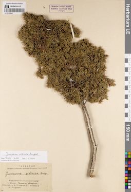
LE 01191646
Juniperus sibirica Burgsd. det. Kuminova, Alexandra Vladimirovna, Minaeva, V.G., Reverdatto, M. at 1945
Additional identifications: Juniperus sibirica Burgsd. det. Orlova, Larisa Vladimirovna at 30.06.2022 Collectors: Kuminova, Alexandra Vladimirovna; Minaeva, V.G.; Reverdatto, M. Collection date: 07.08.1945. Administrative regions: RU - Kemerovskaya Oblast' - Tashtagol'skiy Rayon. Place of collection: г. Мустаг, россыпи вершины.Groups of specimens: Образцы сектора Сибири и Дальнего Востока России; Соглашение Минобрнауки №075-15-2021-1056; Гербарий Западно-Сибирского филиала Академии Наук СССРOriginal label text:Гербарий Западно-Сибирского филиала Академии Наук СССР. Juniperus sibirica Burgs. Кемеровская обл. Кузнецкий Алатау г. Мустаг. Россыпи вершины. 7-VIII-1945. А.В. Куминова, В.Г. Минаева, и М. Ревердатто
Landscape in location of collection: россыпи вершины горыCoordinates (geographic position): 53° 0′ 32.75″ N, 87° 57′ 44.75″ E ±3000 mRecord creation: 2022-07-01, Larisa Orlova, PhotoScan D2. Part 1.Citation: Specimen LE 01191646 // Virtual herbarium of Komarov Botanical Institute RAS — http://re.herbariumle.ru/01191646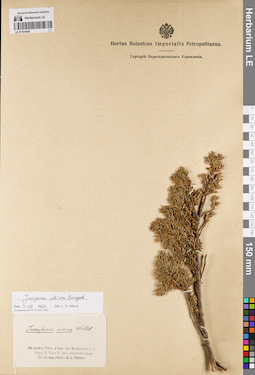
LE 01191645
Juniperus sibirica Burgsd. det. Orlova, Larisa Vladimirovna at 30.06.2022
Additional identifications: Juniperus nana Willd. det. Titov, V. S. at 1910 Collectors: Titov, V. S. Collection date: 23.06.1910. Administrative regions: RU - Kemerovskaya Oblast' - Novokuznetskiy Rayon. Place of collection: водораздел р. Средняя Терсь, р. Большая Уса и р. Черный Июс, альпийсквя тундра.Groups of specimens: Образцы сектора Сибири и Дальнего Востока России; Соглашение Минобрнауки №075-15-2021-1056Original label text:Juniperus nana Willd. На границе Томск. и Енис. губ. Водораздел р. р. Терси, Б. Усы и Ч. Июса. Алпийская тундра. 23-24 июня 1910 г. В. С. Титов
Landscape in location of collection: водораздел трех рекHabitat / plant community in location of collecting: альпийсквя тундраCoordinates (geographic position): 54° 24′ 11.47″ N, 88° 22′ 50.96″ E ±20000 mRecord creation: 2022-07-01, Larisa Orlova, PhotoScan D2. Part 1.Citation: Specimen LE 01191645 // Virtual herbarium of Komarov Botanical Institute RAS — http://re.herbariumle.ru/01191645
LE 01191644
Juniperus sibirica Burgsd. det. Busch
Collectors: Sukaczev, Vladimir Nikolajevich Field collecting number: 618. Collection date: 17.07.1909. Administrative regions: RU - Yamalo-Nenetskiy Avtonomnyy Okrug - Priural'skiy Rayon. Place of collection: Карская тундра, устье р. Брусь-яха, скалистый берег р. Кара.Groups of specimens: Образцы сектора Сибири и Дальнего Востока России; Соглашение Минобрнауки №075-15-2021-1056Object features: 32 стоянкаOriginal label text:Museum Botanicum Academiae Scientiarum Petropolitanae. 618. Juniperus sibirica. Тобольск. г. Березовск. у. Карская тундра. Устье р. Брус-яга. Скалистый берег р. Кары. 32я стоянка. 1909.VII.17. Собр. В. Сукачев
Landscape in location of collection: скалистый берег рекиCoordinates (geographic position): 68° 48′ 48.16″ N, 65° 19′ 59.52″ E ±1000 mRecord creation: 2022-07-01, Larisa Orlova, PhotoScan D2. Part 1.Citation: Specimen LE 01191644 // Virtual herbarium of Komarov Botanical Institute RAS — http://re.herbariumle.ru/01191644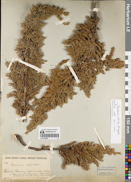
LE 01191643
Juniperus sibirica Burgsd. det. Orlova, Larisa Vladimirovna at 30.06.2022
Additional identifications: Juniperus sibirica Burgsd. det. Busch Collectors: Sukaczev, Vladimir Nikolajevich Field collecting number: 789. Collection date: 14.08.1909. Administrative regions: RU - Yamalo-Nenetskiy Avtonomnyy Okrug - Priural'skiy Rayon. Place of collection: Карская тундра, между р. Нензояха и р. Пензинго-Яха, г. Ярношань, на южном склоне скал.Groups of specimens: Образцы сектора Сибири и Дальнего Востока России; Соглашение Минобрнауки №075-15-2021-1056Original label text:Museum Botanicum Academiae Scientiarum Petropolitanae. 789. Juniperus sibirica. Тобольск. г. Березовск. у. Карская тундра. Между р. Нензи-Яга и р. Пензинго у г. Ярношань. На южном склоне скал. Между 52° и 53°. 1909.VIII.14. В. Сукачев
Landscape in location of collection: южный склон горыHabitat / plant community in location of collecting: тундраCoordinates (geographic position): 68° 17′ 40.05″ N, 67° 57′ 20.51″ E ±50000 mRecord creation: 2022-07-01, Larisa Orlova, PhotoScan D2. Part 1.Citation: Specimen LE 01191643 // Virtual herbarium of Komarov Botanical Institute RAS — http://re.herbariumle.ru/01191643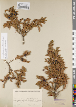
LE 01191642
Juniperus sibirica Burgsd. det. Orlova, Larisa Vladimirovna at 30.06.2022
Collectors: Pohle, Christian Nikolai Richard; Rozhdestvenskij, A. Collection date: 30.06.1913. Administrative regions: RU - Yamalo-Nenetskiy Avtonomnyy Okrug. Place of collection: г. Салехард (с. Обдорское), островок Betula tortuosa с лишайниковым покровом на материке.Groups of specimens: Образцы сектора Сибири и Дальнего Востока России; Соглашение Минобрнауки №075-15-2021-1056Original label text:Museum Botanicum Academiae Scientiarum Petropolitanae. Тобольск. губ. Березовск. у. С. Обдорское. Островок Betula tortuosa с лишайников. покровом на материке. 1913.VI.30. Р. Поле и А. Рождественский
Habitat / plant community in location of collecting: островок Betula tortuosa с лишайниковым покровомCoordinates (geographic position): 66° 31′ 47.52″ N, 66° 36′ 52.23″ E ±20000 mRecord creation: 2022-07-01, Larisa Orlova, PhotoScan D2. Part 1.Citation: Specimen LE 01191642 // Virtual herbarium of Komarov Botanical Institute RAS — http://re.herbariumle.ru/01191642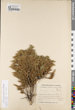
LE 01191641
Juniperus sibirica Burgsd. det. Orlova, Larisa Vladimirovna at 30.06.2022
Additional identifications: Juniperus nana Willd. det. Klopotov, Boris Nikolaevich at 1909 Collectors: Klopotov, Boris Nikolaevich Collection date: 26.06.1909. Administrative regions: RU - Kemerovskaya Oblast'. Subregion: Междуреченский городской округ. Place of collection: вершина горы Топхан-тайга (Тохпан-тайга).Expedition: Б.Н. Клопотов. Экспедиция в Томскую губернию (1909)Groups of specimens: Образцы сектора Сибири и Дальнего Востока России; Соглашение Минобрнауки №075-15-2021-1056; Гербарий Переселенческого УправленияOriginal label text:Гербарий Переселенческого Управления. Б.Н. Клопотов. Экспедиция в Томскую губернию. Juniperus nana WIlld. Кузнецкий Алатау. Бассейн р. Томи. Небольшие приземистые заросли пихты на вершине г. Тохпан-тайга. 1909 26/VI. B. Klopotov. Kuznezky Alatau: reg. flum. Tom.
Landscape in location of collection: вершина горыHabitat / plant community in location of collecting: небольшие приземистые зарослиCoordinates (geographic position): 53° 51′ 35″ N, 88° 32′ 29″ E ±2000 mRecord creation: 2022-07-01, Larisa Orlova, PhotoScan D2. Part 1.Citation: Specimen LE 01191641 // Virtual herbarium of Komarov Botanical Institute RAS — http://re.herbariumle.ru/01191641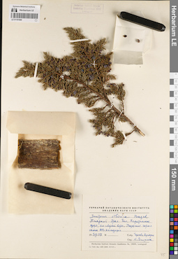
LE 01191640
Juniperus sibirica Burgsd. det. Igoschina, Kapitolina Nikolaevna at 1957
Collectors: Gorelov R. A.; Kuindzhi Collection date: 01.08.1957. Administrative regions: RU - Yamalo-Nenetskiy Avtonomnyy Okrug - Priural'skiy Rayon. Place of collection: Полярный Урал, оз. Большой Хадатаёнганлор (Большое Хадатинское), северный берег, подножие горного склона юго-восточной экспозиции.Groups of specimens: Образцы сектора Сибири и Дальнего Востока России; Соглашение Минобрнауки №075-15-2021-1056Original label text:Гербарий Ботанического института Академии наук СССР. Juniperus sibirica Burgsd. Полярный Урал. Бол. Хадатинское озеро, его северный берег. Подножие горного склона ЮВ экспозиции. 1 VIII 1957. Собр. Горлов и Куинджи. Опр. К. Игошина
Landscape in location of collection: подножие горного склона юго-восточной экспозицииCoordinates (geographic position): 67° 36′ 29.45″ N, 66° 3′ 28.66″ E ±1000 mRecord creation: 2022-07-01, Larisa Orlova, PhotoScan D2. Part 1.Citation: Specimen LE 01191640 // Virtual herbarium of Komarov Botanical Institute RAS — http://re.herbariumle.ru/01191640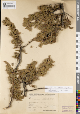
LE 01191639
Juniperus sibirica Burgsd. det. Orlova, Larisa Vladimirovna at 30.06.2022
Additional identifications: Juniperus communis L. det. Sochava, Viktor Borisovich at 1926; Juniperus sibirica Burgsd. det. Busch Collectors: Sochava, Viktor Borisovich Field collecting number: 254. Collection date: 07.08.1926. Administrative regions: RU - Yamalo-Nenetskiy Avtonomnyy Okrug - Priural'skiy Rayon. Place of collection: верховья р. Хайма [?] и р. Нырдвоменшор (Нырдомен), верхняя часть склона перидотитовой горы, выше границы леса.Expedition: Северо-Уральская экспедиция Академии Наук и Уралплана (1926 -1928)Groups of specimens: Образцы сектора Сибири и Дальнего Востока России; Соглашение Минобрнауки №075-15-2021-1056Original label text:Museum Botanicum Academiae Scientiarum Petropolitanae. Северо-Уральская экспедиция Академии Наук и Уралплана. № 254. Juniperus sibirica Burkh. [communis L. - crossed out] Полярный Урал. Басс. р. Сыни. Верховья р. Хайма и р. Нырдомен. Верхн. часть склона перидотитовой горы. Выше границы леса. 1926.VIIi.7. В.Б. Сочава
Landscape in location of collection: верхняя часть склона перидотитовой горыHabitat / plant community in location of collecting: выше границы лесаCoordinates (geographic position): 67° 1′ 7.95″ N, 65° 27′ 29.25″ E ±200000 mRecord creation: 2022-07-01, Larisa Orlova, PhotoScan D2. Part 1.Citation: Specimen LE 01191639 // Virtual herbarium of Komarov Botanical Institute RAS — http://re.herbariumle.ru/01191639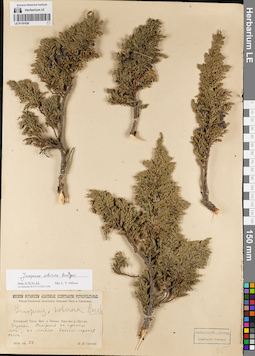
LE 01191638
Juniperus sibirica Burgsd. det. Orlova, Larisa Vladimirovna at 30.06.2022
Additional identifications: Juniperus sibirica Burgsd. det. Busch Collectors: Sochava, Viktor Borisovich Collection date: 22.07.1928. Administrative regions: RU - Komi - Ust'-Tsilemskiy Rayon. Place of collection: бассейн р. Печора, верховья р. Щугор, заросли Juniperus на границе леса, на местах долгого лежания снега.Expedition: Северо-Уральская экспедиция Академии Наук и Уралплана (1926 -1928)Groups of specimens: Образцы сектора Сибири и Дальнего Востока России; Соглашение Минобрнауки №075-15-2021-1056Original label text:Museum Botanicum Academiae Scientiarum Petropolitanae. Северо-Уральская экспедиция Академии Наук и Уралплана. Juniperus sibirica Burkh. Северный Урал. Басс. р. Печеры. Верховья р. Щугора. Заросли Juniperus на границе леса, на местах долгого лежания снега. 1928.VII.22. В.Б. Сочава
Habitat / plant community in location of collecting: заросли Juniperus на границе леса, на местах долгого лежания снегаCoordinates (geographic position): 64° 26′ 12.87″ N, 51° 5′ 0.87″ E ±10000 mRecord creation: 2022-07-01, Larisa Orlova, PhotoScan D2. Part 1.Citation: Specimen LE 01191638 // Virtual herbarium of Komarov Botanical Institute RAS — http://re.herbariumle.ru/01191638