View
Add
Copy
Edit
Delete
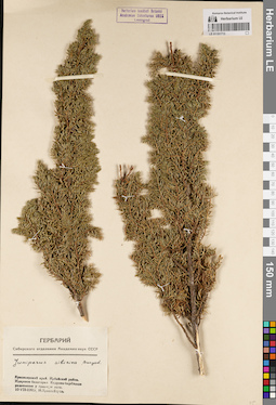
LE 01191737
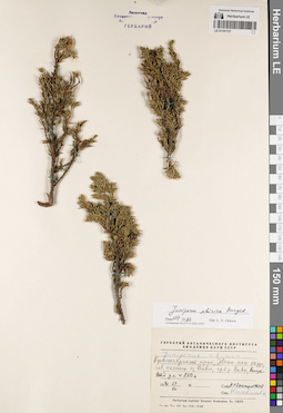
Juniperus sibirica Burgsd. det. Orlova, Larisa Vladimirovna at 01.07.2022
Additional identifications: Juniperus sibirica Burgsd. det. Kozhevnikov, Yury Pavlovich Collectors: Snigirevskaya, Natalya Sergeevna Collection date: 23.07.1970. Administrative regions: RU - Krasnoyarskiy Kray - Evenkiyskiy District. Place of collection: северная оконечность оз. Виви, правый берег р. Вивихорон (Виви).Groups of specimens: Образцы сектора Сибири и Дальнего Востока России; Соглашение Минобрнауки №075-15-2021-1056Original label text:Гербарий Ботанического института Академии наук СССР. Juniperus sibirica. Красноярский край, Эвенк. нац. округ, сев. оконечн. оз. Виви, пр. б. р. Виви, высота над ул. ок. 850 м. 1970.23.VII. Собр. Н.С. Снигиревская. Опр. Кожевников Ю.
Landscape in location of collection: берег рекиCoordinates (geographic position): 67° 7′ 46.46″ N, 93° 56′ 58.79″ E ±5000 m, 850 m a.s.l.Record creation: 2022-07-01, Larisa Orlova, PhotoScan D2. Part 1.Citation: Specimen LE 01191737 // Virtual herbarium of Komarov Botanical Institute RAS — http://re.herbariumle.ru/01191737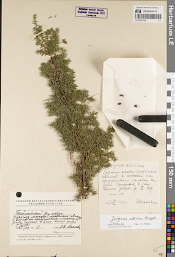
LE 01191736
Juniperus sibirica Burgsd. det. Orlova, Larisa Vladimirovna at 01.07.2022
Additional identifications: Juniperus sibirica Burgsd. det. Makhaeva L.V. at 1959 Collectors: Makhaeva L.V. Field collecting number: 11. Collection date: 12.08.1959. Administrative regions: RU - Krasnoyarskiy Kray - Taymyrsky Dolgano-Nenetsky District. Place of collection: заросли мохово-травяных ивняков с ольхой на прирусловом склоне к р. Соленая в 1 км выше устья р. Большой Яр.Groups of specimens: Образцы сектора Сибири и Дальнего Востока России; Соглашение Минобрнауки №075-15-2021-1056Original label text:[1]Juniperus sibiricus. Заросли мохово-травяных ивняков с ольхой на прирусловом склоне к реке Соленой в 1 км выше устья р. Б. Яр. опис. N 11. 12/VIII-59 г. Махаева [2] Гербарий Ботанического института Академии наук СССР. Таймырский Нац. округ. Заросли мохово-травяных ивняков с ольхой на прирусловом склоне к реке Соленой в 2 км. выше устья р. Б. Яр. 1959 11/VIII. N 11. Собр. Л.В. Махаева
Landscape in location of collection: прирусловой склон к рекеHabitat / plant community in location of collecting: заросли мохово-травяных ивняков с ольхой на прирусловом склонеCoordinates (geographic position): 68° 14′ 51.07″ N, 85° 8′ 32.85″ E ±1000 mRecord creation: 2022-07-01, Larisa Orlova, PhotoScan D2. Part 1.Citation: Specimen LE 01191736 // Virtual herbarium of Komarov Botanical Institute RAS — http://re.herbariumle.ru/01191736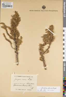
LE 01191735
Juniperus sibirica Burgsd. det. Orlova, Larisa Vladimirovna at 01.07.2022
Additional identifications: Juniperus nana Willd. det. Troizky, W.P. at 1912 Collectors: Troizky, W.P. Collection date: 29.06.1912. Administrative regions: RU - Krasnoyarskiy Kray - Sayanskiy Rayon. Place of collection: долина р. Дикий (Ералашный) Кан (истоки р. Кан до слияния с р. Тихой).Expedition: В.П. Троицкий: Растения Саянских гор (1912 -1913)Groups of specimens: Образцы сектора Сибири и Дальнего Востока России; Соглашение Минобрнауки №075-15-2021-1056Original label text:В.П. Троицкий: Растения Саянских гор. Juniperus nana Willd. Енисейская губ. Канский уезд: Дол. реки Ералашного (Дикого) Кана. 1912 29 VI. W.P. Troizky: Plantae montes Sajanensium
Landscape in location of collection: долина рекиCoordinates (geographic position): 54° 19′ 37.61″ N, 95° 34′ 11.68″ E ±10000 mRecord creation: 2022-07-01, Larisa Orlova, PhotoScan D2. Part 1.Citation: Specimen LE 01191735 // Virtual herbarium of Komarov Botanical Institute RAS — http://re.herbariumle.ru/01191735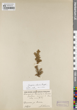
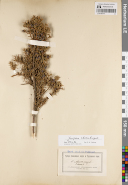
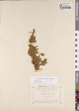
LE 01191734
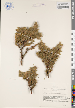
Juniperus sibirica Burgsd. det. Orlova, Larisa Vladimirovna at 01.07.2022
Additional identifications: Juniperus communis ssp. nana (Willd.) Syme det. Krylov, Porphyriy Nikitich Collectors: Totto, A. Collection date: 24.08.1914. Administrative regions: RU - Krasnoyarskiy Kray - Sayanskiy Rayon. Place of collection: Саяны, долина р. Кан.Groups of specimens: Образцы сектора Сибири и Дальнего Востока России; Соглашение Минобрнауки №075-15-2021-1056Original label text:Museum Botanicum Academiae Scientiarum Petropolitanae. Канский у. Енисейск. г. Саяны. Juniperus communis L. subsp. nana (Willd.) (Крыл.) Долина р. Кана. 24 VIII 1914. А. Тотто
Landscape in location of collection: долина горной рекиCoordinates (geographic position): 54° 51′ 28″ N, 95° 11′ 58.46″ E ±40000 mRecord creation: 2022-07-01, Larisa Orlova, PhotoScan D2. Part 1.Citation: Specimen LE 01191734 // Virtual herbarium of Komarov Botanical Institute RAS — http://re.herbariumle.ru/01191734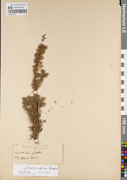
LE 01191733
Juniperus sibirica Burgsd. det. Orlova, Larisa Vladimirovna at 01.07.2022
Additional identifications: Juniperus communis var. nana Willd. det. Fuss, Victor Collectors: Fuss, Victor Collection date: 09.09.1881. Administrative regions: RU - Khanty-Mansiyskiy Avtonomnyy Okrug-Yugra - Beryozovsky Rayon. Place of collection: у р. Обь, возле пос. Березово.Groups of specimens: Образцы сектора Сибири и Дальнего Востока России; Соглашение Минобрнауки №075-15-2021-1056Original label text:Juniperus communis L. var. nana W. Leg. Victor Fuss. 9 Sept 1881. Ad fl. Ob, prope Beresowo
Landscape in location of collection: берег крупной рекиCoordinates (geographic position): 63° 56′ 8.73″ N, 65° 25′ 8.45″ E ±3000 mRecord creation: 2022-07-01, Larisa Orlova, PhotoScan D2. Part 1.Citation: Specimen LE 01191733 // Virtual herbarium of Komarov Botanical Institute RAS — http://re.herbariumle.ru/01191733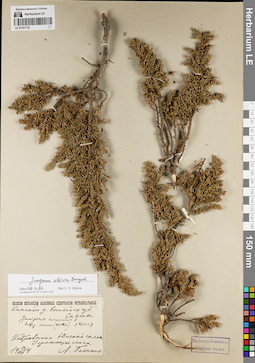
LE 01191732
Juniperus sibirica Burgsd. det. Orlova, Larisa Vladimirovna at 01.07.2022
Additional identifications: Juniperus communis ssp. nana (Willd.) Syme det. Krylov, Porphyriy Nikitich Collectors: Totto, A. Collection date: 19.07.1914. Administrative regions: RU - Respublika Tyva; RU - Krasnoyarskiy Kray - Sayanskiy Rayon. Place of collection: хр. Саяны, южный склон, кедровники, у границы леса.Groups of specimens: Образцы сектора Сибири и Дальнего Востока России; Соглашение Минобрнауки №075-15-2021-1056Original label text:Museum Botanicum Academiae Scientiarum Petropolitanae. Канский у. Енисейск. губ. Саяны. Juniperus communis L. subsp. nana (Willd.) (Крыл.) Кедровники. Южный склон. У границы леса. 19 VII 1914. А. Тотто
Landscape in location of collection: южный склон горного хребтаHabitat / plant community in location of collecting: кедровникCoordinates (geographic position): 53° 13′ 25.64″ N, 95° 14′ 8.42″ E ±200000 mRecord creation: 2022-07-01, Larisa Orlova, PhotoScan D2. Part 1.Citation: Specimen LE 01191732 // Virtual herbarium of Komarov Botanical Institute RAS — http://re.herbariumle.ru/01191732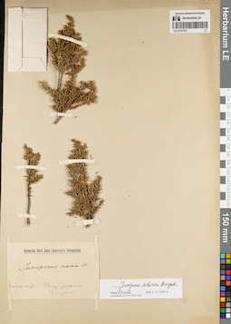
LE 01191731
Collectors: Ulrich Groups of specimens: Образцы сектора Сибири и Дальнего Востока России; Соглашение Минобрнауки №075-15-2021-1056Record creation: 2022-07-01, Larisa Orlova, PhotoScan D2. Part 1.Citation: Specimen LE 01191731 // Virtual herbarium of Komarov Botanical Institute RAS — http://re.herbariumle.ru/01191731
LE 01191730
Juniperus sibirica Burgsd. det. Krasnikov, A., Schein, V., Maneev, A.G. at 1980
Collectors: Krasnikov, A.; Maneev, A.G.; Schein, V. Collection date: 16.07.1980. Administrative regions: RU - Respublika Tyva - Mongun-Tayginskiy Rayon. Subregion: Монгун-Тайгинский кожуун. Place of collection: хр. Чихачева, долина р. Чеди-тей (Джеты-Тей) в среднем течении, крупнокаменистая зарастающая осыпь.Groups of specimens: Образцы сектора Сибири и Дальнего Востока России; Соглашение Минобрнауки №075-15-2021-1056; Гербарий Центрального Сибирского ботанического сада СО АН СССРOriginal label text:Гербарий Центрального Сибирского ботанического сада СО АН СССР. Juniperus sibirica Burgsd. Тувинская АССР, Монгун-Тайгинский р-н., хр. Чихачева. Долина р. Джеты-тей в среднем течении. Крупнокаменистая зарастающая осыпь. 16.7.1980г. А. Красников, А. Манеев, В. Шеин
Landscape in location of collection: крупнокаменистая зарастающая осыпь в долине рекиCoordinates (geographic position): 50° 13′ 36.85″ N, 89° 30′ 51.84″ E ±2000 mRecord creation: 2022-07-01, Larisa Orlova, PhotoScan D2. Part 1.Citation: Specimen LE 01191730 // Virtual herbarium of Komarov Botanical Institute RAS — http://re.herbariumle.ru/01191730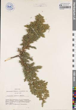
LE 01191729
Juniperus sibirica Burgsd. det. Maneev, A.G., Sidorenko, N. at 1981
Collectors: Maneev, A.G.; Sidorenko, N. Collection date: 26.07.1981. Administrative regions: RU - Respublika Altay - Kosh-Agachskiy Rayon. Place of collection: хр. Чихачева, долина р. Текелю (левый приток р. Бугузун), выс. 2300 м, правый берег ручья.Groups of specimens: Образцы сектора Сибири и Дальнего Востока России; Соглашение Минобрнауки №075-15-2021-1056; Гербарий Центрального Сибирского ботанического сада СО АН СССРOriginal label text:Гербарий Центрального Сибирского ботанического сада СО АН СССР. Juniperus sibirica Burgds. Алтай, Кош-Агачский р-н, хр. Чихачева, дол. р. Текелю (левый приток р. Бугузун). 50° 5' c.ш. 89° 25' в.д. Выс. 2300м. Правый берег ручья. 26.7.1981г. А. Манеев, Н. Сидоренко
Landscape in location of collection: правый берег ручьяCoordinates (geographic position): 50° 0′ 4.78″ N, 89° 24′ 26.54″ E ±10000 m, 2300 m a.s.l.Record creation: 2022-07-01, Larisa Orlova, PhotoScan D2. Part 1.Citation: Specimen LE 01191729 // Virtual herbarium of Komarov Botanical Institute RAS — http://re.herbariumle.ru/01191729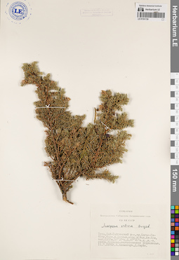
LE 01191728
Juniperus sibirica Burgsd. det. Khanminchun, Valery Mikhailovich, Shaulo Dmitry Nikolaevich at 1976
Collectors: Khanminchun, Valery Mikhailovich; Shaulo Dmitry Nikolaevich Collection date: 11.07.1976. Administrative regions: RU - Respublika Tyva. Subregion: Бай-Тайгинский кожуун. Place of collection: хр. Цаган-Шибету, бассейн р. Барлык, верховья р. Малый Ак-Хем, выс. 2300 м, 50° 30' с.ш. 90° 45' в.д., юго-восточный склон, кедрово-лиственничное редколесье.Groups of specimens: Образцы сектора Сибири и Дальнего Востока России; Соглашение Минобрнауки №075-15-2021-1056; Гербарий Центрального Сибирского ботанического сада СО АН СССРOriginal label text:Гербарий Центрального Сибирского ботанического сада СО АН СССР. Juniperus sibirica Burgsd. Тува, Бай-Тайгинский р-н, хр. Цаган-Шибету, басс. р. Барлык, верх. р. Мал. Ак-Хем, выс. 2300м. 50° 30' с.ш. 90° 45' в.д., ю.-в. склон. Кедрово-лиственничное редколесье. 11.7.1976г. В. Ханминчун, Д. Шауло
Landscape in location of collection: юго-восточный склонHabitat / plant community in location of collecting: кедрово-лиственничное редколесьеCoordinates (geographic position): 50° 38′ 17.21″ N, 90° 21′ 51.42″ E ±4000 mRecord creation: 2022-07-01, Larisa Orlova, PhotoScan D2. Part 1.Citation: Specimen LE 01191728 // Virtual herbarium of Komarov Botanical Institute RAS — http://re.herbariumle.ru/01191728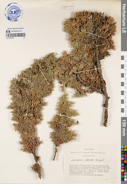
LE 01191727
Juniperus sibirica Burgsd. det. Khanminchun, Valery Mikhailovich, Shaulo Dmitry Nikolaevich at 1976
Collectors: Khanminchun, Valery Mikhailovich; Shaulo Dmitry Nikolaevich Collection date: 11.07.1976. Administrative regions: RU - Respublika Tyva. Subregion: Бай-Тайгинский кожуун. Place of collection: хр. Цаган-Шибету, бассейн р. Барлык, верховья р. Малый Ак-Хем, выс. 2300 м, 50° 30' с.ш. 90° 45' в.д., юго-восточный склон, альпийские лужайки среди крупнокаменистых россыпей.Groups of specimens: Образцы сектора Сибири и Дальнего Востока России; Соглашение Минобрнауки №075-15-2021-1056; Гербарий Центрального Сибирского ботанического сада СО АН СССРOriginal label text:Гербарий Центрального Сибирского ботанического сада СО АН СССР. Juniperus sibirica Burgsd. Тува, Бай-Тайгинский р-н, хр. Цаган-Шибету, басс. р. Барлык, верх. р. Мал. Ак-Хем, выс. 2300м. 50° 30' с.ш. 90° 45' в.д., ю.-в. склон. Альпийские лужайки среди крупнокаменистых россыпей. 11.7.1976г. В. Ханминчун, Д. Шауло
Landscape in location of collection: крупнокаменистые россыпи на юго-восточном склонеHabitat / plant community in location of collecting: альпийские лужайки среди крупнокаменистых россыпейCoordinates (geographic position): 50° 38′ 43.8″ N, 90° 21′ 8.05″ E ±5000 mRecord creation: 2022-07-01, Larisa Orlova, PhotoScan D2. Part 1.Citation: Specimen LE 01191727 // Virtual herbarium of Komarov Botanical Institute RAS — http://re.herbariumle.ru/01191727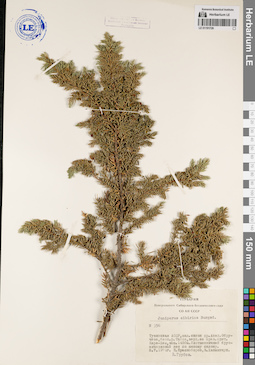
LE 01191726
Juniperus sibirica Burgsd. det. Grubov, Valery Ivanovich at 1974
Collectors: Khanminchun, Valery Mikhailovich; Krasnoborov, Ivan Moiseevich Field collecting number: 356. Collection date: 08.07.1974. Administrative regions: RU - Respublika Tyva. Subregion: Кызылский кожуун. Place of collection: западный склон хр. Акад. Обручева, бассейн р. Тапса, верховья ее правого притока р. Кара-Хем, выс. 1400м, лиственничный брусничниковый лес по южному склону.Groups of specimens: Образцы сектора Сибири и Дальнего Востока России; Соглашение Минобрнауки №075-15-2021-1056; Гербарий Центрального Сибирского ботанического сада СО АН СССРOriginal label text:Гербарий Центрального Сибирского ботанического сада СО АН СССР. Juniperus sibirica Burgsd. N 356. Тувинская АССР, зап. склон хр. Акад. Обручева, басс. р. Тапса, верх. ее прав. прит. Кара-Хем, выс. 1400м. Лиственничный брусничниковый лес по южному склону. 8.7.1974г. И. Красноборов, В. Ханминчун. В. Грубов
Landscape in location of collection: южный склонHabitat / plant community in location of collecting: лиственничный брусничниковый лес по южному склонуCoordinates (geographic position): 51° 58′ 31.14″ N, 95° 18′ 25.21″ E ±2000 mRecord creation: 2022-07-01, Larisa Orlova, PhotoScan D2. Part 1.Citation: Specimen LE 01191726 // Virtual herbarium of Komarov Botanical Institute RAS — http://re.herbariumle.ru/01191726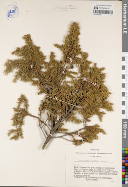
LE 01191725
Juniperus sibirica Burgsd. det. Bel'skaya, I., Khanminchun, Valery Mikhailovich, Rozhitsyna, V. at 1979
Collectors: Rozhitsyna, V.; Khanminchun, Valery Mikhailovich; Bel'skaya, I. Field collecting number: 36. Collection date: 17.08.1979. Administrative regions: RU - Respublika Tyva - Erzinskiy Rayon. Place of collection: нагорье Сангилен, бассейн р. Эрзин, верховья р. Кара-Суг (приток р. Улар), выс. 2280 м, юго-восточный склон (30°), ерники в комплексе со злаками, осочками и разнотравьем.Groups of specimens: Образцы сектора Сибири и Дальнего Востока России; Соглашение Минобрнауки №075-15-2021-1056; Гербарий Центрального Сибирского ботанического сада СО АН СССРOriginal label text:Гербарий Центрального Сибирского ботанического сада СО АН СССР. Juniperus sibirica Burgsd. № 36. Тува, Эрзинский р-н, нагорье Сангилен, басс. р. Эрзин, верх. р. Кара-Суг (прит. р. Улар), выс. 2280 м, юго-вост. склон (30°). Ерники в комплексе со злаками, осочками и разнотравьем. 17.8.1979г. В. Ханминчун, В. Рожицына, И. Бельская
Landscape in location of collection: юго-восточный склон к реке (30°)Habitat / plant community in location of collecting: ерники в комплексе со злаками, осочками и разнотравьемCoordinates (geographic position): 50° 29′ 25.19″ N, 95° 27′ 32.48″ E ±3000 m, 2280 m a.s.l.Record creation: 2022-07-01, Larisa Orlova, PhotoScan D2. Part 1.Citation: Specimen LE 01191725 // Virtual herbarium of Komarov Botanical Institute RAS — http://re.herbariumle.ru/01191725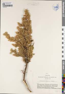
LE 01191724
Juniperus sibirica Burgsd. det. Rozhitsyna, V., Khanminchun, Valery Mikhailovich, Polev, Yu. at 1979
Collectors: Khanminchun, Valery Mikhailovich; Rozhitsyna, V.; Polev, Yu. Field collecting number: 53. Collection date: 10.08.1979. Administrative regions: RU - Respublika Tyva. Subregion: Тес-Хемский кожуун. Place of collection: нагорье Сангилен, хр. Остроконечный Танну-Ола, междуречье верховьев р. Кускунуг-Хем и р. Шурмак, выс. 2020 м, выше границы леса, ерниковая тундра.Groups of specimens: Образцы сектора Сибири и Дальнего Востока России; Соглашение Минобрнауки №075-15-2021-1056; Гербарий Центрального Сибирского ботанического сада СО АН СССРOriginal label text:Гербарий Центрального Сибирского ботанического сада СО АН СССР. Juniperus sibirica Burgsd. № 53. Тува, нагорье Сангилен, хр. Остроконечный Танну-Ола, междуречье верх. р. Кускунуг-Хем и р. Шурмак, выс. 2020м. Выше границы леса. Ерниковая тундра. 10.8.1979г. В. Ханминчун, В. Рожицына, Ю. Полев
Landscape in location of collection: склон горного хребта выше границы лесаHabitat / plant community in location of collecting: ерниковая тундраCoordinates (geographic position): 50° 35′ 37.09″ N, 95° 15′ 38.54″ E ±5000 mRecord creation: 2022-07-01, Larisa Orlova, PhotoScan D2. Part 1.Citation: Specimen LE 01191724 // Virtual herbarium of Komarov Botanical Institute RAS — http://re.herbariumle.ru/01191724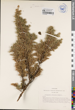
LE 01191723
Juniperus sibirica Burgsd. det. Khanminchun, Valery Mikhailovich, Danilov, M., Kritzin, A. at 1979
Collectors: Khanminchun, Valery Mikhailovich; Danilov, M.; Kritzin, A. Field collecting number: 56. Collection date: 03.08.1979. Administrative regions: RU - Respublika Tyva. Subregion: Тес-Хемский кожуун. Place of collection: нагорье Сангилен, хр. Остроконечный Танну-Ола, среднее течение р. Кускуннуг-Хем (приток р. Шурмак), вершина сопки, выс. 1650 м, голубично-зеленомошная гарь с порослью березы.Groups of specimens: Образцы сектора Сибири и Дальнего Востока России; Соглашение Минобрнауки №075-15-2021-1056; Гербарий Центрального Сибирского ботанического сада СО АН СССРOriginal label text:Гербарий Центрального Сибирского ботанического сада СО АН СССР. Juniperus sibirica Burgsd. № 56. Тува, нагорье Сангилен, хр. остроконечный Танну-Ола, сред. теч. р. Кускуннуг-Хем, (прит. р. Шурмак), вершина сопки, выс. 1650м. Голубично-зеленомошная гарь с порослью березы. 3.8.1979г. В. Ханминчун, М. Данилов, А. Крицын
Landscape in location of collection: вершина сопкиHabitat / plant community in location of collecting: голубично-зеленомошная гарь с порослью березыCoordinates (geographic position): 50° 37′ 26.37″ N, 95° 11′ 12.63″ E ±3000 mRecord creation: 2022-07-01, Larisa Orlova, PhotoScan D2. Part 1.Citation: Specimen LE 01191723 // Virtual herbarium of Komarov Botanical Institute RAS — http://re.herbariumle.ru/01191723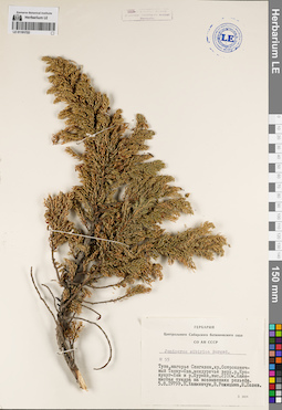
LE 01191722
Juniperus sibirica Burgsd. det. Rozhitsyna, V., Khanminchun, Valery Mikhailovich, Polev, Yu. at 1979
Collectors: Rozhitsyna, V.; Khanminchun, Valery Mikhailovich; Polev, Yu. Field collecting number: 55. Collection date: 05.08.1979. Administrative regions: RU - Respublika Tyva. Subregion: Тес-Хемский кожуун. Place of collection: нагорье Сангилен, хр. Остроконечный Танну-Ола, междуречье верховьев р. Кускунуг-Хем и р. Шурмак, выс. 2100 м, каменистая тундра на возвышениях рельефа.Groups of specimens: Образцы сектора Сибири и Дальнего Востока России; Соглашение Минобрнауки №075-15-2021-1056; Гербарий Центрального Сибирского ботанического сада СО АН СССРOriginal label text:Гербарий Центрального Сибирского ботанического сада СО АН СССР. Juniperus sibirica Burgsd. № 55. Тува, нагорье Сангилен, хр. Остроконечный Танну-Ола, междуречье верх. р. Кускунуг-Хем и р. Шурмак, выс. 2100м. Каменистая тундра на возвышениях рельефа. 5.8.1979г. В. Ханминчун, В. Рожицына, Ю. Полев
Landscape in location of collection: склон горного хребтаHabitat / plant community in location of collecting: каменистая тундра на возвышениях рельефаCoordinates (geographic position): 50° 34′ 12.28″ N, 95° 16′ 14.26″ E ±5000 m, 2100 m a.s.l.Record creation: 2022-07-01, Larisa Orlova, PhotoScan D2. Part 1.Citation: Specimen LE 01191722 // Virtual herbarium of Komarov Botanical Institute RAS — http://re.herbariumle.ru/01191722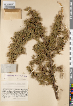
LE 01191721
Juniperus sibirica Burgsd. det. Vassiljev, Viktor Nikolayevich at 1948
Collectors: Sokolov, Ph.V. Field collecting number: 122. Collection date: 09.1947. Administrative regions: RU - Krasnoyarskiy Kray - Turukhanskiy Rayon. Place of collection: окрестности с. Старотуруханск, левобережный останец р. Турухан и р. Енисей несколько ниже устья р. Нижняя Тунгуска, смешанный хвойно-мелко-лиственный лес.Groups of specimens: Образцы сектора Сибири и Дальнего Востока России; Соглашение Минобрнауки №075-15-2021-1056Original label text:Herbarium Instituti Botanici Academiae Sc. URSS. Туруханский р-н. Красноярского края. Возле с. Старо-Туруханск. Левобережный останец р. Турухан и р. Енисей. Несколько ниже устья р. Н. Тунгуски. м. острова Монастырки. Смешанный хвойно-мелко-лиственный лес. 1947 VIII-IX. собр. Ф.В. Соколов
Landscape in location of collection: левобережный останец крупных рекHabitat / plant community in location of collecting: смешанный хвойно-мелко-лиственный лесCoordinates (geographic position): 65° 57′ 19.68″ N, 87° 51′ 14.75″ E ±20000 mRecord creation: 2022-07-01, Larisa Orlova, PhotoScan D2. Part 1.Citation: Specimen LE 01191721 // Virtual herbarium of Komarov Botanical Institute RAS — http://re.herbariumle.ru/01191721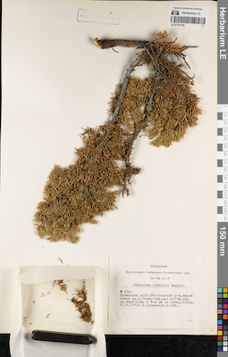
LE 01191720
Juniperus sibirica Burgsd. det. Khanminchun, Valery Mikhailovich, Idt, N. at 1972
Collectors: Khanminchun, Valery Mikhailovich; Idt, N. Field collecting number: 4041. Collection date: 21.07.1972. Administrative regions: RU - Respublika Tyva. Subregion: Тес-Хемский кожуун. Place of collection: южный склон хр. Восточный Танну-Ола, выс. 2010 м, окрестности оз. Кара-Холь, 6 км севернее оз. Кара-Холь, скалы.Groups of specimens: Образцы сектора Сибири и Дальнего Востока России; Соглашение Минобрнауки №075-15-2021-1056; Гербарий Центрального Сибирского ботанического сада СО АН СССРOriginal label text:Гербарий Центрального Сибирского ботанического сада СО АН СССР. Juniperus sibirica Burgsd. № 4041. Тувинская АССР, Тес-Хемский р-н, южный склон хр. В. Танну-Ола, выс. 2010 м, окр. оз. Кара-Холь в 6-и км на север. Скалы. 21.7.1972г. В. Ханминчун, Н. Идт
Landscape in location of collection: скалыCoordinates (geographic position): 50° 58′ 37.42″ N, 94° 19′ 15.91″ E ±200 mRecord creation: 2022-07-01, Larisa Orlova, PhotoScan D2. Part 1.Citation: Specimen LE 01191720 // Virtual herbarium of Komarov Botanical Institute RAS — http://re.herbariumle.ru/01191720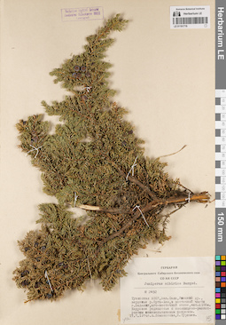
LE 01191719
Juniperus sibirica Burgsd. det. Lomonosova, Maria Nikolaevna, Kurlaev, B. at 1974
Collectors: Lomonosova, Maria Nikolaevna; Kurlaev, B. Field collecting number: 2492. Collection date: 17.07.1974. Administrative regions: RU - Respublika Tyva. Subregion: Улуг-Хемский кожуун. Place of collection: Уюкский хр., верховье р. Ортаа-Хем, восточная часть г. Беделиг, юго-восточный склон, выс. 2100 м, кедровое редколесье с овсяницево-разнотравным можжевельниковым покровом.Groups of specimens: Образцы сектора Сибири и Дальнего Востока России; Соглашение Минобрнауки №075-15-2021-1056; Гербарий Центрального Сибирского ботанического сада СО АН СССРOriginal label text:Гербарий Центрального Сибирского ботанического сада СО АН СССР. Juniperus sibirica Burgsd. № 2492. Тувинская АССР, Зап. Саян, Уюкский хр., верховье р. Орта-Хем, в восточной части г. Беделиг, юго-восточный склон, выс. 2100м. Кедровое редколесье с овсяницево-разнотравным можевельниковым покровом. 17.7.1974г. М. Ломоносова, Б. Курлаев
Landscape in location of collection: юго-восточный склон горыHabitat / plant community in location of collecting: кедровое редколесье с овсяницево-разнотравным можжевельниковым покровомCoordinates (geographic position): 51° 46′ 39.35″ N, 92° 28′ 38.02″ E ±2000 m, 2100 m a.s.l.Record creation: 2022-07-01, Larisa Orlova, PhotoScan D2. Part 1.Citation: Specimen LE 01191719 // Virtual herbarium of Komarov Botanical Institute RAS — http://re.herbariumle.ru/01191719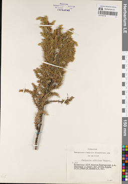
LE 01191718
Juniperus sibirica Burgsd. det. Danilov, M., Ens, P. at 1980
Collectors: Danilov, M.; Ens, P. Field collecting number: 952. Collection date: 10.08.1980. Administrative regions: RU - Respublika Tyva - Mongun-Tayginskiy Rayon. Subregion: Монгун-Тайгинский кожуун. Place of collection: верховье р. Чарыс (Джаарс, Джарс), выс. 2550 м, Курум.Groups of specimens: Образцы сектора Сибири и Дальнего Востока России; Соглашение Минобрнауки №075-15-2021-1056; Гербарий Центрального Сибирского ботанического сада СО АН СССРOriginal label text:Гербарий Центрального Сибирского ботанического сада СО АН СССР. Juniperus sibirica Burgsd. N 952. Тувинская АССР, Монгун-Тайгинский р-н. Верховья р. Джарс, выс. 2550м. Курум. 10.8.1980г. М. Данилов, П. Энс
Landscape in location of collection: берег горной рекиCoordinates (geographic position): 50° 11′ 6.48″ N, 89° 55′ 12.29″ E ±3000 m, 2550 m a.s.l.Record creation: 2022-07-01, Larisa Orlova, PhotoScan D2. Part 1.Citation: Specimen LE 01191718 // Virtual herbarium of Komarov Botanical Institute RAS — http://re.herbariumle.ru/01191718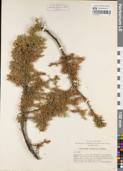
LE 01191717
Juniperus sibirica Burgsd. det. Khanminchun, Valery Mikhailovich, Berezovskij, A. at 1972
Collectors: Khanminchun, Valery Mikhailovich; Berezovskij, A. Field collecting number: 4061. Collection date: 14.07.1972. Administrative regions: RU - Respublika Tyva. Subregion: Тес-Хемский кожуун. Place of collection: южный склон хр. Восточный Танну-Ола, выс. 1940 м, окрестности оз. Кара-Холь в 4 км на юг, кедрово-лиственничный лес на вершине горы.Groups of specimens: Образцы сектора Сибири и Дальнего Востока России; Соглашение Минобрнауки №075-15-2021-1056; Гербарий Центрального Сибирского ботанического сада СО АН СССРOriginal label text:Гербарий Центрального Сибирского ботанического сада СО АН СССР. Juniperus sibirica Burgsd. № 4061. Тувинская АССР, Тес-Хемский р-н, южный склон хр. В. Танну-Ола, выс. 1940м, окр. оз. Кара-Холь в 4км на юг. Кедрово-лиственничный лес на вершине горы. 14.7.1972г. В. Ханминчун, А. Березовский
Landscape in location of collection: вершина горыHabitat / plant community in location of collecting: кедрово-лиственничный лесCoordinates (geographic position): 50° 52′ 39.99″ N, 94° 18′ 26.28″ E ±1000 m, 1940 m a.s.l.Record creation: 2022-07-01, Larisa Orlova, PhotoScan D2. Part 1.Citation: Specimen LE 01191717 // Virtual herbarium of Komarov Botanical Institute RAS — http://re.herbariumle.ru/01191717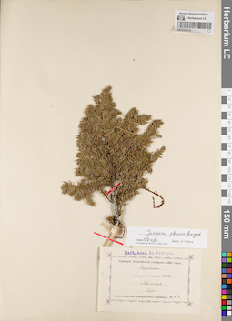
LE 01191716
Juniperus nana Willd. det. Martyanov, Nikolay Mikhailovich at 1891
Additional identifications: Juniperus sibirica Burgsd. det. Orlova, Larisa Vladimirovna at 01.07.2022 Field collecting number: 676. Collection date: 06.1891. Administrative regions: RU - Krasnoyarskiy Kray. Place of collection: Енисейская губерния, горы.Groups of specimens: Образцы сектора Сибири и Дальнего Востока России; Соглашение Минобрнауки №075-15-2021-1056; Гербарий Енисейской губернии. 1891 год. Красноярская учительская семинарияOriginal label text:Herb. Acad. Sc. Petropol. Гербарий Енисейской губернии. 1891 год. Cupressineae. Juniperus nana. Willd. Май и Июнь. Горы. Красноярская учительская семинария. № 676
Landscape in location of collection: горыCoordinates (geographic position): 56° 0′ 38.05″ N, 92° 51′ 9.26″ E ±200000 mRecord creation: 2022-07-01, Larisa Orlova, PhotoScan D2. Part 1.Citation: Specimen LE 01191716 // Virtual herbarium of Komarov Botanical Institute RAS — http://re.herbariumle.ru/01191716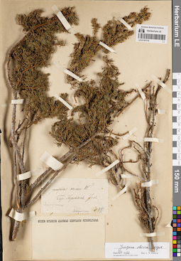
LE 01191715
Groups of specimens: Образцы сектора Сибири и Дальнего Востока России; Соглашение Минобрнауки №075-15-2021-1056Record creation: 2022-07-01, Larisa Orlova, PhotoScan D2. Part 1.Citation: Specimen LE 01191715 // Virtual herbarium of Komarov Botanical Institute RAS — http://re.herbariumle.ru/01191715
LE 01191714
Groups of specimens: Образцы сектора Сибири и Дальнего Востока России; Соглашение Минобрнауки №075-15-2021-1056Record creation: 2022-07-01, Larisa Orlova, PhotoScan D2. Part 1.Citation: Specimen LE 01191714 // Virtual herbarium of Komarov Botanical Institute RAS — http://re.herbariumle.ru/01191714
LE 01191713
Juniperus sibirica Burgsd. det. Krasnoborov, Ivan Moiseevich at 1961
Collectors: Krasnoborov, Ivan Moiseevich Collection date: 10.08.1961. Administrative regions: RU - Krasnoyarskiy Kray - Irbeyskiy Rayon. Place of collection: хр. Идарское белогорье, кедрово-берёзовое редколесье у границы леса.Groups of specimens: Образцы сектора Сибири и Дальнего Востока России; Соглашение Минобрнауки №075-15-2021-1056; Гербарий Сибирского отделения Академии наук СССРOriginal label text:Гербарий Сибирского отделения Академии наук СССР. Juniperus sibirica Burgsd. Красноярский край. Ирбейский район. Идарское белогорье. Кедрово-берёзовое редколесье у границы леса. 10-VIII-1961г. И. Красноборов
Landscape in location of collection: склон горного хребтаHabitat / plant community in location of collecting: кедрово-берёзовое редколесье у границы лесаCoordinates (geographic position): 54° 49′ 10.96″ N, 95° 34′ 10.22″ E ±10000 mRecord creation: 2022-07-01, Larisa Orlova, PhotoScan D2. Part 1.Citation: Specimen LE 01191713 // Virtual herbarium of Komarov Botanical Institute RAS — http://re.herbariumle.ru/01191713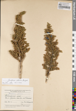
LE 01191712
Juniperus sibirica Burgsd. det. Orlova, Larisa Vladimirovna at 01.07.2022
Additional identifications: Juniperus sibirica Burgsd. det. Busch Collectors: Belorussova, Zh.M. Collection date: 20.07.1962. Administrative regions: RU - Krasnoyarskiy Kray - Turukhanskiy Rayon. Place of collection: бассейн р. Турухан, южный берег оз. Большой Дюгакиш.Groups of specimens: Образцы сектора Сибири и Дальнего Востока России; Соглашение Минобрнауки №075-15-2021-1056Original label text:Гербарий Ботанического института Академии Наук СССР. Juniperus sibirica. Красноярский край. басс. р. Турухан, южн. бер. оз. Б. Дюгакиш. 1962 20 VII. Собр. Ж.М. Белорусова
Landscape in location of collection: берег озераCoordinates (geographic position): 67° 15′ 6.97″ N, 83° 26′ 10″ E ±10000 mRecord creation: 2022-07-01, Larisa Orlova, PhotoScan D2. Part 1.Citation: Specimen LE 01191712 // Virtual herbarium of Komarov Botanical Institute RAS — http://re.herbariumle.ru/01191712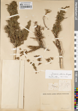
LE 01191711
Groups of specimens: Образцы сектора Сибири и Дальнего Востока России; Соглашение Минобрнауки №075-15-2021-1056Record creation: 2022-07-01, Larisa Orlova, PhotoScan D2. Part 1.Citation: Specimen LE 01191711 // Virtual herbarium of Komarov Botanical Institute RAS — http://re.herbariumle.ru/01191711
LE 01191710
Juniperus sibirica Burgsd. det. Orlova, Larisa Vladimirovna at 01.07.2022
Additional identifications: Juniperus nana Willd. det. Martyanov, Nikolay Mikhailovich at 1891 Field collecting number: 676. Collection date: 06.1891. Administrative regions: RU - Krasnoyarskiy Kray. Place of collection: Енисейская губерния, горы.Groups of specimens: Образцы сектора Сибири и Дальнего Востока России; Соглашение Минобрнауки №075-15-2021-1056; Гербарий Енисейской губернии. 1891 год. Красноярская учительская семинарияOriginal label text:Herb. Acad. Sc. Petropol. Гербарий Енисейской губернии. 1891 год. Cupressineae. Juniperus nana Willd. Май и Июнь. Горы. Красноярская учительская семинария. № 676
Landscape in location of collection: горыCoordinates (geographic position): 56° 0′ 38.05″ N, 92° 51′ 9.26″ E ±500000 mRecord creation: 2022-07-01, Larisa Orlova, PhotoScan D2. Part 1.Citation: Specimen LE 01191710 // Virtual herbarium of Komarov Botanical Institute RAS — http://re.herbariumle.ru/01191710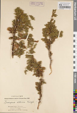
LE 01191709
Juniperus sibirica Burgsd. det. Gluzdakov, S. at 1948
Collectors: Gluzdakov, S. Collection date: 15.07.1948. Administrative regions: RU - Irkutskaya Oblast' - Nizhneudinskiy Rayon. Place of collection: Тофалария, долина р. Кара-Бурень (приток р. Уда), кустарниковая тундра.Groups of specimens: Образцы сектора Сибири и Дальнего Востока России; Соглашение Минобрнауки №075-15-2021-1056; Гербарий Западно-Сибирского филиала Академии Наук СССРOriginal label text:Гербарий Западно-Сибирского филиала Академии Наук СССР. Juniperus sibirica Burgsd. Восточные Саяны. Тофалария. Долина р. Кара-Бурень. (пр. р. Уда). Кустарниковая тундра. 53° 10' с.ш. 98° 26' в.д.15-VII-1948г. С. Глуздаков
Landscape in location of collection: долина рекиHabitat / plant community in location of collecting: кустарниковая тундраCoordinates (geographic position): 53° 8′ 49.75″ N, 98° 24′ 33.12″ E ±50000 mRecord creation: 2022-07-01, Larisa Orlova, PhotoScan D2. Part 1.Citation: Specimen LE 01191709 // Virtual herbarium of Komarov Botanical Institute RAS — http://re.herbariumle.ru/01191709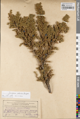
LE 01191708
Juniperus sibirica Burgsd. det. Orlova, Larisa Vladimirovna at 01.07.2022
Additional identifications: Juniperus nana Willd. det. IIjin, Modest Mikhailovich at 1931 Collectors: IIjin, Modest Mikhailovich; Ovchinnikov B. N. Field collecting number: 396. Collection date: 24.08.1931. Administrative regions: RU - Krasnoyarskiy Kray - Shushenskiy Rayon. Place of collection: Западные Саяны, берег высокогорного озера в истоках р. Большой Чисплет (Б. Чисплек, приток р. Кантегир).Expedition: М.М. Ильин, Б.Н. Овчинников и А.Ф. Иванова. Минусинская экспедиция (1931)Groups of specimens: Образцы сектора Сибири и Дальнего Востока России; Соглашение Минобрнауки №075-15-2021-1056; Гербарий Всесоюзного Научно-исследовательского института каучука и гуттаперчиOriginal label text:Гербарий Всесоюзного Научно-Исследовательского Института каучука и гуттаперчи. М.М. Ильин, Б.Н. Овчинников и А.Ф. Иванова. Минусинская экспедиция. Juniperus nana Willd. Минусинский окр. Западные Саяны. Берег высокогорного озера в истоках р. Б. Чисплек /приток р. Кантегирь/ 24 VIII 1931 г. № 396. Leg. М. Ильин и Б. Овч. Det. М. Иль[ин]
Landscape in location of collection: берег высокогорного озераCoordinates (geographic position): 52° 32′ 13.34″ N, 90° 58′ 44.69″ E ±2000 mRecord creation: 2022-07-01, Larisa Orlova, PhotoScan D2. Part 1.Citation: Specimen LE 01191708 // Virtual herbarium of Komarov Botanical Institute RAS — http://re.herbariumle.ru/01191708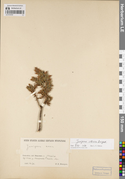
LE 01191707
Juniperus sibirica Burgsd. det. Orlova, Larisa Vladimirovna at 01.07.2022
Additional identifications: Juniperus nana Willd. det. Nesterov, P.V. at 1907 Collectors: Nesterov, P.V. Collection date: 26.06.1907. Administrative regions: RU - Krasnoyarskiy Kray - Yermakovskiy Rayon. Place of collection: среднее течение р. Нижняя Буйба, тайга, луг.Groups of specimens: Образцы сектора Сибири и Дальнего Востока России; Соглашение Минобрнауки №075-15-2021-1056Original label text:Museum Botanicum Academiae Scientiarum Petropolitanae. Juniperus nana. Енисейск. губ. Минусинск. у. Тайга. ср. теч. р. Нижняя Буйба. Луг. 1907.VI.26. П.В. Нестеров
Landscape in location of collection: берег рекиHabitat / plant community in location of collecting: тайга, лугCoordinates (geographic position): 52° 43′ 59.43″ N, 93° 23′ 15.58″ E ±20000 mRecord creation: 2022-07-01, Larisa Orlova, PhotoScan D2. Part 1.Citation: Specimen LE 01191707 // Virtual herbarium of Komarov Botanical Institute RAS — http://re.herbariumle.ru/01191707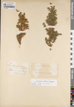
LE 01191706
Groups of specimens: Образцы сектора Сибири и Дальнего Востока России; Соглашение Минобрнауки №075-15-2021-1056Record creation: 2022-07-01, Larisa Orlova, PhotoScan D2. Part 1.Citation: Specimen LE 01191706 // Virtual herbarium of Komarov Botanical Institute RAS — http://re.herbariumle.ru/01191706
LE 01191705
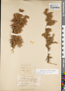
Juniperus sibirica Burgsd. det. Orlova, Larisa Vladimirovna at 01.07.2022
Additional identifications: Juniperus sp. det. Markjelow, J.; Juniperus communis var. alpina Suter det. Glehn, Peter von. Collectors: Markjelow, J. Collection date: 20.05.1866. Administrative regions: RU - Krasnoyarskiy Kray - Severo-Yeniseyskiy Rayon. Place of collection: р. Севагликон.Groups of specimens: Образцы сектора Сибири и Дальнего Востока России; Соглашение Минобрнауки №075-15-2021-1056; Museum botan. Acad. Petrop.Original label text:[1]Juniperus sp. Севагликон. Мая 20. [2]Museum botan. Acad. Petrop. Juniperus communis L. var. alpina Laud. = J. communis L. var. nana Trautv. (teste Glehn) Ssewaglikon 20 May. Regio Jenisseae aurifera inter fl. Pit et Tunguscam mediam 60° leg. J. Markjelow. 1866
Landscape in location of collection: берег рекиCoordinates (geographic position): 59° 10′ 45.29″ N, 94° 0′ 7.6″ E ±10000 mRecord creation: 2022-07-01, Larisa Orlova, PhotoScan D2. Part 1.Citation: Specimen LE 01191705 // Virtual herbarium of Komarov Botanical Institute RAS — http://re.herbariumle.ru/01191705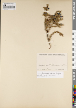
LE 01191704
Collectors: Kytmanov, Alexander Ignatievich Groups of specimens: Образцы сектора Сибири и Дальнего Востока России; Соглашение Минобрнауки №075-15-2021-1056Record creation: 2022-07-01, Larisa Orlova, PhotoScan D2. Part 1.Citation: Specimen LE 01191704 // Virtual herbarium of Komarov Botanical Institute RAS — http://re.herbariumle.ru/01191704
LE 01191703
Juniperus sibirica Burgsd. det. Orlova, Larisa Vladimirovna at 01.07.2022
Additional identifications: Juniperus nana Willd. det. Busch Collectors: Woronov, Jurij (Georg) Nikolaewich Field collecting number: 44. Collection date: 06.06.1903. Administrative regions: RU - Krasnoyarskiy Kray - Manskiy Rayon. Place of collection: система р. Мана, берег р. Мана выше устья р. Курандум.Groups of specimens: Образцы сектора Сибири и Дальнего Востока России; Соглашение Минобрнауки №075-15-2021-1056Original label text:Museum Botanicum Academiae Scientiarum Petropolitanae. no. 44. Juniperus nana W. Енисейская губ., Минусинский окр. Система р. Маны. Берег Маны выше устья Курандум. 1903.6.VI Собр. Ю. Воронов
Landscape in location of collection: берег крупной рекиCoordinates (geographic position): 55° 21′ 52.19″ N, 93° 34′ 5.57″ E ±100000 mRecord creation: 2022-07-01, Larisa Orlova, PhotoScan D2. Part 1.Citation: Specimen LE 01191703 // Virtual herbarium of Komarov Botanical Institute RAS — http://re.herbariumle.ru/01191703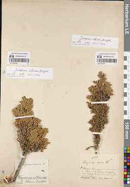
LE 01191702
Juniperus sibirica Burgsd. det. Orlova, Larisa Vladimirovna at 01.07.2022
Additional identifications: Juniperus nana Willd. det. Adrianow, Alexander Vassiliewich, Andreew Collectors: Wenzkowsky, Alexander Ivanovich; Clemenz, Dmitriy Aleksandrowich Collection date: 09.1884. Administrative regions: RU - Respublika Khakasiya. Place of collection: восточная Сибирь [район р. Абакан].Expedition: Wenzkowsky et Clemenz: Pl. Sibriae occidentalis (1883 -1884)Groups of specimens: Образцы сектора Сибири и Дальнего Востока России; Соглашение Минобрнауки №075-15-2021-1056Original label text:Juniperus nana L. Wenzkowsky et Clemenz: Pl. Sibriae occidentalis. V-IX 1884
Coordinates (geographic position): 52° 38′ 22.66″ N, 90° 9′ 19.6″ E ±150000 mRecord creation: 2022-07-01, Larisa Orlova, PhotoScan D2. Part 1.Citation: Specimen LE 01191702 // Virtual herbarium of Komarov Botanical Institute RAS — http://re.herbariumle.ru/01191702
LE 01191701
Juniperus sibirica Burgsd. det. Orlova, Larisa Vladimirovna at 01.07.2022
Additional identifications: Juniperus nana Willd. det. Adrianow, Alexander Vassiliewich at 1883 Collectors: Adrianow, Alexander Vassiliewich Field collecting number: 86. Collection date: 07.08.1883. Administrative regions: RU - Respublika Khakasiya. Subregion: Таштыпский район. Place of collection: гор. Крест-Таскыва (гора между р. Малый Абакан и рр. Большой и Малый Кизас).Expedition: A.V. Adrianow: Altai et Trans Sajan 1883 (1883)Groups of specimens: Образцы сектора Сибири и Дальнего Востока России; Соглашение Минобрнауки №075-15-2021-1056Object features: Кустарник низкорослыйOriginal label text:N 86. Juniperus nana W. 7го августа. Кустарник низкорослый на вершинах Крест-Таскыва (гора между М. Абаканом и Б. и Малым Кызасом. Adrianow: Altai et Trans Sajan 1883
Landscape in location of collection: склон горыCoordinates (geographic position): 52° 13′ 42.31″ N, 89° 4′ 47.87″ E ±10000 mRecord creation: 2022-07-01, Larisa Orlova, PhotoScan D2. Part 1.Citation: Specimen LE 01191701 // Virtual herbarium of Komarov Botanical Institute RAS — http://re.herbariumle.ru/01191701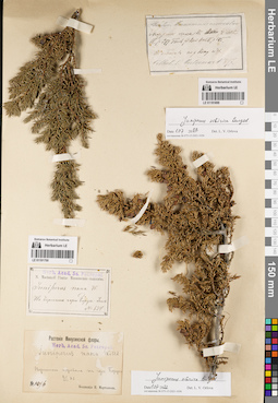
LE 01191699
Juniperus sibirica Burgsd. det. Orlova, Larisa Vladimirovna at 01.07.2022
Additional identifications: Juniperus nana Willd. det. Busch Collectors: Martyanov, Nikolay Mikhailovich Field collecting number: 897. Administrative regions: RU - Krasnoyarskiy Kray. Place of collection: тайга по р. Копь.Expedition: N. Martianoff. Plantae Minusinensis exsiccatae ()Groups of specimens: Образцы сектора Сибири и Дальнего Востока России; Соглашение Минобрнауки №075-15-2021-1056Original label text:Plantae Minusinensis exsiccatae. Juniperus nana W. H. Alh. IV p. 299 Turch Fl.Bai.- Dah. III p. 145. В тайгах по р. Кону и др. Collect. N. Martianow N 897.
Landscape in location of collection: берег рекиHabitat / plant community in location of collecting: тайгаCoordinates (geographic position): 53° 39′ 4.17″ N, 93° 21′ 34.88″ E ±150000 mRecord creation: 2022-07-01, Larisa Orlova, PhotoScan D2. Part 1.Citation: Specimen LE 01191699 // Virtual herbarium of Komarov Botanical Institute RAS — http://re.herbariumle.ru/01191699
LE 01191700
Juniperus nana Willd. det. Martyanov, Nikolay Mikhailovich
Collectors: Martyanov, Nikolay Mikhailovich Field collecting number: 634. Collection date: 07. Administrative regions: RU - Krasnoyarskiy Kray - Shushenskiy Rayon. Place of collection: вершина гор. Борус.Expedition: N. Martianoff. Plantae Minusinensis exsiccatae ()Groups of specimens: Образцы сектора Сибири и Дальнего Востока России; Соглашение Минобрнауки №075-15-2021-1056; Herb. Acad. Sc. Petropol.Original label text:Herb. Acad. Sc. Petropol. N. Martianoff Plantae Minusinensis exsiccatae. Juniperus nana W. На вершине горы Борус.- Июль. № 634
Landscape in location of collection: вершина горыCoordinates (geographic position): 52° 47′ 10.93″ N, 91° 31′ 58.12″ E ±2000 mRecord creation: 2022-07-01, Larisa Orlova, PhotoScan D2. Part 1.Citation: Specimen LE 01191700 // Virtual herbarium of Komarov Botanical Institute RAS — http://re.herbariumle.ru/01191700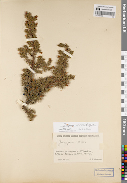
LE 01191698
Juniperus sibirica Burgsd. det. Orlova, Larisa Vladimirovna at 01.07.2022
Additional identifications: Juniperus nana Willd. det. Nesterov, P.V. at 1907 Collectors: Nesterov, P.V. Collection date: 23.06.1907. Administrative regions: RU - Krasnoyarskiy Kray - Yermakovskiy Rayon. Place of collection: гора близ оз. Ойское, высота 2100 м.Groups of specimens: Образцы сектора Сибири и Дальнего Востока России; Соглашение Минобрнауки №075-15-2021-1056Original label text:Museum Botanicum Academiae Scientiarum Petropolitanae. Juniperus nana. Енисейск. губ. Минусинск. у. Тайга. гора бл. Ойского оз. Высота 7000 ф. 1907.VI.23. П.В. Нестеров
Landscape in location of collection: склон горыCoordinates (geographic position): 52° 51′ 16.3″ N, 93° 15′ 26.47″ E ±2000 m, 2133 m a.s.l.Record creation: 2022-07-01, Larisa Orlova, PhotoScan D2. Part 1.Citation: Specimen LE 01191698 // Virtual herbarium of Komarov Botanical Institute RAS — http://re.herbariumle.ru/01191698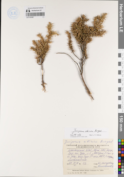
LE 01191697
Juniperus sibirica Burgsd. det. Orlova, Larisa Vladimirovna at 01.07.2022
Additional identifications: Juniperus sibirica Burgsd. det. Kozhevnikov, Yury Pavlovich Collectors: Snigirevskaya, Natalya Sergeevna Field collecting number: 1/2. Collection date: 29.06.1969. Administrative regions: RU - Krasnoyarskiy Kray - Evenkiyskiy District. Place of collection: окрестности пос. Тура, левый берег р. Кочечум, в 1 км от ее устья, близ базы 5й эксп. АГК, 1-2 террасы, лиственничник.Groups of specimens: Образцы сектора Сибири и Дальнего Востока России; Соглашение Минобрнауки №075-15-2021-1056Original label text:juniperus sibirica Burgsd. Гербарий Ботанического института Академии наук СССР. Красноярский край, Эвенк. нац. округ, окр. пос. Тура, л.б. р. Кочечумо, в 1 км от ее устья, близ базы 5й эксп. АГК, 1-2 террасы, лиственничник. 1969 27-29 VI. N 1/2. Собр. Н.С. Снигиревская Опр. Кожевников Ю. Herbarium Instituti Botanici Academiae Sc. URSS
Landscape in location of collection: 1-2 террасы рекиHabitat / plant community in location of collecting: лиственничникCoordinates (geographic position): 64° 17′ 20.86″ N, 100° 12′ 17.02″ E ±1000 mRecord creation: 2022-07-01, Larisa Orlova, PhotoScan D2. Part 1.Citation: Specimen LE 01191697 // Virtual herbarium of Komarov Botanical Institute RAS — http://re.herbariumle.ru/01191697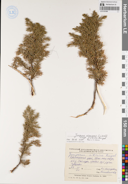
LE 01191696
Juniperus niemannii E.L. Wolf ⟨close to Juniperus sibirica Burgsd.⟩ det. Orlova, Larisa Vladimirovna at 30.06.2022
Additional identifications: Juniperus sibirica Burgsd. det. Kozhevnikov, Yury Pavlovich Collectors: Snigirevskaya, Natalya Sergeevna Collection date: 11.07.1969. Administrative regions: RU - Krasnoyarskiy Kray - Evenkiyskiy District. Place of collection: левый берег р. Таймура, правый борт руч. Чувакан.Groups of specimens: Образцы сектора Сибири и Дальнего Востока России; Соглашение Минобрнауки №075-15-2021-1056Original label text:Гербарий Ботанического института Академии наук СССР. Juniperus sibirica Burgsd. Красноярский край, Эвенк. нац. округ, л.б. р. Таймуры, правый борт ручья Чувакан. 1969 11 VII. Собр. Н.С. Снигиревская. Опр. Кожевников Ю. Herbarium Instituti Botanici Academiae Sc. URSS
Landscape in location of collection: берег ручьяCoordinates (geographic position): 63° 0′ 22.99″ N, 99° 57′ 12.22″ E ±130000 mRecord creation: 2022-07-01, Larisa Orlova, PhotoScan D2. Part 1.Citation: Specimen LE 01191696 // Virtual herbarium of Komarov Botanical Institute RAS — http://re.herbariumle.ru/01191696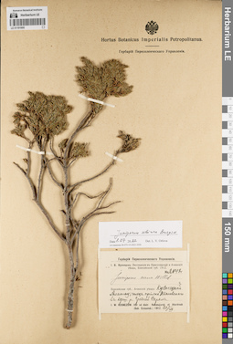
LE 01191695
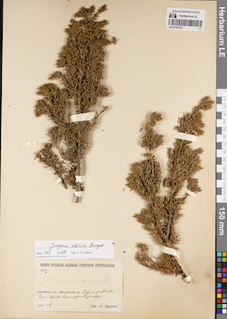
Juniperus sibirica Burgsd. det. Orlova, Larisa Vladimirovna at 01.07.2022
Additional identifications: Juniperus nana Willd. det. Orlova, Larisa Vladimirovna at 1912 Collectors: Kusnezow (Kuznetszov, Kusnezov), Ivan Vasilievich Field collecting number: 2142. Collection date: 20.07.1912. Administrative regions: RU - Respublika Khakasiya - Ordzhonikidzevskiy Rayon. Place of collection: хр. Кузнецкий Алатау, Ивановский голец прииска Ивановского, верховья р. Средняя Сарана.Groups of specimens: Образцы сектора Сибири и Дальнего Востока России; Соглашение Минобрнауки №075-15-2021-1056Original label text:Гербарий Переселенческого Управления. И.В. Кузнецов: Экспедиция в Красноярский и Ачинский уезды, Енисейской губ. 1912. № 2142. Juniperus nana Willd. Енисейская губ., Ачинский уезд: Кузнецкий Алатау; голец прииска Ивановского в верш. р. Средней Саралы. i.W.Kusnezow: Iter ad distr. Krasnojarsk et Atschinsk (Gub. Enisseisk.) 1912.20/VII
Landscape in location of collection: склон гольцаCoordinates (geographic position): 54° 38′ 30.72″ N, 88° 36′ 39.91″ E ±3000 mRecord creation: 2022-07-01, Larisa Orlova, PhotoScan D2. Part 1.Citation: Specimen LE 01191695 // Virtual herbarium of Komarov Botanical Institute RAS — http://re.herbariumle.ru/01191695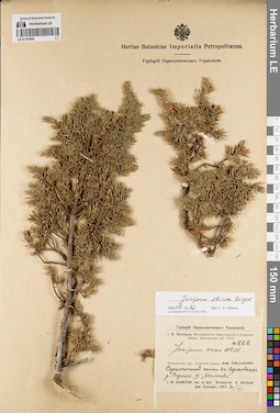
LE 01191694
Juniperus sibirica Burgsd. det. Orlova, Larisa Vladimirovna at 01.07.2022
Additional identifications: Juniperus nana Willd. det. Kusnezow (Kuznetszov, Kusnezov), Ivan Vasilievich at 1912 Collectors: Kusnezow (Kuznetszov, Kusnezov), Ivan Vasilievich Field collecting number: 666. Collection date: 20.07.1912. Administrative regions: RU - Krasnoyarskiy Kray - Berezovskiy rayon; RU - Respublika Khakasiya - Ordzhonikidzevskiy Rayon. Place of collection: склон сопки Саралинская в верховьях р. Сарала, у белков.Expedition: И.В. Кузнецов: Экспедиция в Красноярский и Ачинский уезды, Енисейской губ. 1912 (1912)Groups of specimens: Образцы сектора Сибири и Дальнего Востока России; Соглашение Минобрнауки №075-15-2021-1056; Гербарий Переселенческого УправленияOriginal label text:Гербарий Переселенческого Управления. И.В. Кузнецов: Экспедиция в Красноярский и Ачинский уезды, Енисейской губ. 1912. № 666. Juniperus nana Will. Енисейская губ., Ачинский уезд: на склоне Саралинской сопки в верховьях р. Саралы у "белков". I.W. Kusnezow: Iter ad distr. Krasnojarsk et Atschinsk (Gub. Enisseisk.) 1912.20/VII
Landscape in location of collection: склон сопкиCoordinates (geographic position): 54° 38′ 33.37″ N, 88° 38′ 59.88″ E ±5000 mRecord creation: 2022-07-01, Larisa Orlova, PhotoScan D2. Part 1.Citation: Specimen LE 01191694 // Virtual herbarium of Komarov Botanical Institute RAS — http://re.herbariumle.ru/01191694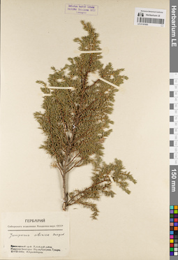
LE 01191693
Juniperus sibirica Burgsd. det. Krasnoborov, Ivan Moiseevich at 1961
Collectors: Krasnoborov, Ivan Moiseevich Collection date: 13.08.1961. Administrative regions: RU - Krasnoyarskiy Kray - Irbeyskiy Rayon. Place of collection: хр. Идарское Белогорье, окрестности оз. Кускунак, тундра.Groups of specimens: Образцы сектора Сибири и Дальнего Востока России; Соглашение Минобрнауки №075-15-2021-1056; Гербарий Сибирского отделения Академии наук СССРOriginal label text:Гербарий Сибирского отделения Академии наук СССР. Juniperus sibirica Burgsd. Красноярский край. Ирбейский район. Идарское белогорье. Окр. оз. Кускунак. Тундра. 13-VIII-1961г. И. Красноборов
Habitat / plant community in location of collecting: тундраCoordinates (geographic position): 54° 49′ 29.15″ N, 95° 34′ 43.77″ E ±1000 mRecord creation: 2022-07-01, Larisa Orlova, PhotoScan D2. Part 1.Citation: Specimen LE 01191693 // Virtual herbarium of Komarov Botanical Institute RAS — http://re.herbariumle.ru/01191693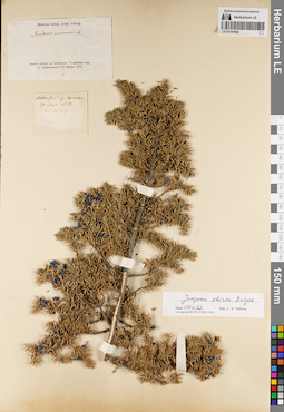
LE 01191692
Juniperus sibirica Burgsd. det. Orlova, Larisa Vladimirovna at 01.07.2022
Additional identifications: Juniperus communis L. Collectors: Czekanowski, Alexander Piotr; Müller (Mueller), Ferdinand Ferdinandovich Collection date: 29.06.1873. Administrative regions: RU - Irkutskaya Oblast' - Katangskiy Rayon. Place of collection: обнажение р. Холак.Groups of specimens: Образцы сектора Сибири и Дальнего Востока России; Соглашение Минобрнауки №075-15-2021-1056Original label text:[1]Museum botan. Acad. Petrop. Sibiria orient. ad Inferiorem Tunguskam legg. A. Czekanowski et F. Müller 1873 [2] Обнажение р. Холака 29 June 1873 62°28' с.ш.
Landscape in location of collection: обнажение по рекеCoordinates (geographic position): 62° 29′ 0″ N, 108° 0′ 0″ E ±200000 mRecord creation: 2022-07-01, Larisa Orlova, PhotoScan D2. Part 1.Citation: Specimen LE 01191692 // Virtual herbarium of Komarov Botanical Institute RAS — http://re.herbariumle.ru/01191692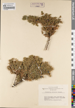
LE 01191691
Juniperus sibirica Burgsd. det. Krasnoborov, Ivan Moiseevich at 1970
Collectors: Krasnoborov, Ivan Moiseevich Collection date: 14.07.1970. Administrative regions: RU - Respublika Tyva. Subregion: Сут-Хольский кожуун. Place of collection: Западный Саян, хр. Саянский, верховья р. Алды-Ишкин, среди гранитных валунов.Groups of specimens: Образцы сектора Сибири и Дальнего Востока России; Соглашение Минобрнауки №075-15-2021-1056; Гербарий Центрального Сибирского ботанического сада СО АН СССРOriginal label text:Гербарий Центрального Сибирского ботанического сада СО АН СССР. Juniperus sibirica Burgsd. Тува, Западный Саян, Саянский хр. Верх. Алды-Ишкина. Среди гранитных валунов. 14.07.1970г. И. Красноборов
Landscape in location of collection: гранитные валуныCoordinates (geographic position): 51° 49′ 25.41″ N, 91° 4′ 6.18″ E ±10000 mRecord creation: 2022-07-01, Larisa Orlova, PhotoScan D2. Part 1.Citation: Specimen LE 01191691 // Virtual herbarium of Komarov Botanical Institute RAS — http://re.herbariumle.ru/01191691
LE 01191690
Juniperus sibirica Burgsd. det. Orlova, Larisa Vladimirovna at 01.07.2022
Collectors: Middendorff, Alexander Fedorovich Collection date: 1844. Administrative regions: RU - Omskaya Oblast' - Nazyvayevskiy Rayon. Place of collection: с. Налимово.Groups of specimens: Образцы сектора Сибири и Дальнего Востока России; Соглашение Минобрнауки №075-15-2021-1056Original label text:Nalimovo Siberiae Middn. 1944
Coordinates (geographic position): 55° 38′ 56.04″ N, 71° 49′ 9.12″ E ±10000 mRecord creation: 2022-07-01, Larisa Orlova, PhotoScan D2. Part 1.Citation: Specimen LE 01191690 // Virtual herbarium of Komarov Botanical Institute RAS — http://re.herbariumle.ru/01191690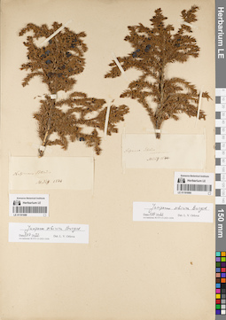
LE 01191689
Juniperus sibirica Burgsd. det. Orlova, Larisa Vladimirovna at 01.07.2022
Collectors: Middendorff, Alexander Fedorovich Collection date: 1844. Administrative regions: RU - Omskaya Oblast' - Nazyvayevskiy Rayon. Place of collection: с. Налимово.Groups of specimens: Образцы сектора Сибири и Дальнего Востока России; Соглашение Минобрнауки №075-15-2021-1056Original label text:Nalimowo Siberiae. Middn. 1844
Coordinates (geographic position): 55° 38′ 56.04″ N, 71° 49′ 9.12″ E ±10000 mRecord creation: 2022-07-01, Larisa Orlova, PhotoScan D2. Part 1.Citation: Specimen LE 01191689 // Virtual herbarium of Komarov Botanical Institute RAS — http://re.herbariumle.ru/01191689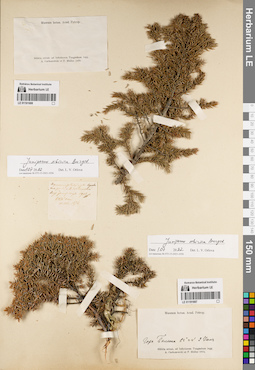
LE 01191688
Collectors: Czekanowski, Alexander Piotr; Müller (Mueller), Ferdinand Ferdinandovich Collection date: 11.08.1873. Administrative regions: RU - Irkutskaya Oblast' - Katangskiy Rayon. Place of collection: р. Нижняя Тунгуска, вершина горы вправо от устья р. В. Габышева.Groups of specimens: Образцы сектора Сибири и Дальнего Востока России; Соглашение Минобрнауки №075-15-2021-1056Original label text:
[1]Museum botan. Acad. Petrop. Sibiria orient. ad Inferiorem Tunguskam legg. A. Czekanowski et F. Müller 1873 [2] Вершина [...] горы вправо от устья р. В. Габышевой. выше [...] Тунг. 1988 ф. 64 1/2° с.ш. 11.Авг. 1873
Landscape in location of collection: вершина горыCoordinates (geographic position): 62° 5′ 0″ N, 108° 0′ 0″ E ±200000 m, 608 m a.s.l.Record creation: 2022-07-01, Larisa Orlova, PhotoScan D2. Part 1.Citation: Specimen LE 01191688 // Virtual herbarium of Komarov Botanical Institute RAS — http://re.herbariumle.ru/01191688